The Wade Roads
The Jacobite Rebellions
In 1688, James VII of Scotland, II of England, lost
his throne to William and Mary. His supporters, the
Jacobites, were mostly Highlanders and Catholic, and
were deeply hostile to the Hanoverian regime and to
its mostly Protestant supporters in the Lowlands. They
carried out a number of uprisings, most notably in 1715
and 1745, in an attempt to restore the House of Stuart.
The government responded by building forts and passing
the Disarming Act after the 1715 rebellion although
this left loyal Highlanders who had surrendered their
arms defenceless against those who had not. The Highlands
were also much troubled by cattle thieving with raids
reaching as far as the Lowlands. This was eventually
controlled by the use of Independent Companies of loyal
Highlanders (the origin of the Black Watch) whose local
knowledge and understanding of Gaelic gave them an advantage
over English soldiers. However, the trouble flared up
again when they themselves became involved in the theft
of cattle; this led to them being disbanded in 1717.
With troubles continuing, Lord Lovat sent a report to
London in 1724 and effectively recommended that he be
put in charge of the region. As he was well known for
his self-serving actions the government sent its own
man, General Wade, to carry out a survey of the effectiveness
of measures taken so far, and to propose any new measures
as necessary.
Wade’s report
George Wade was born in 1673 and had a successful military
career becoming a Major General by 1711 and eventually
a Field Marshal. He was also the MP for Bath. He had
been successful in countering the Jacobite threat in
the south-west of England at the time of the 1715 rising
and this may be the reason the government decided that
he was the best person to report on the situation.
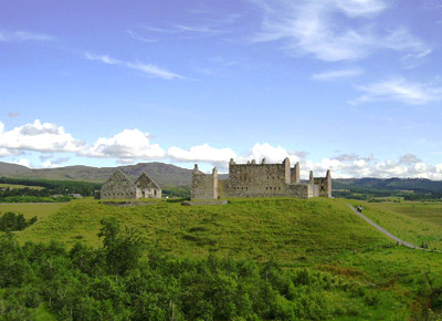 |
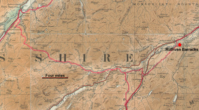
| Ruthven Barracks |
He assessed the number of fighting men that could be mustered
by the clans as about 12,000, potentially a significant
threat. He recommended the building of barracks, improving
local arrangements for the administration of the law,
the passing of further disarming legislation, and forming
additional independent companies. In particular he noted
that the lack of roads and bridges made it very difficult
to control the country - the garrisons were very much
cut off from each other and it was difficult to bring
troops and artillery up from the south in case of trouble.
Note: Wade's report (and Lovat's) can be found in Burt's
Letters from a Gentleman in the North of Scotland, volume
2.
Appointment and initial actions
His report was well received for soon afterwards he was
appointed Commander in Chief of His Majesty's forces,
castles, forts and barracks in North Britain and tasked
to implement his proposed measures. Although these were
measures intended to control the population, his bluff,
affable personality went a long way towards reducing the
hostility towards the Hanoverian regime that would otherwise
have been felt. When he left this was eroded through high-handed
and oppressive actions by the government.
His first acts were aimed at disarming the Highlanders
and training new independent companies then at building
new barracks and restoring the forts along the Great Glen.
He then concentrated on his road building programme.
The road network
 The
road network was determined in large part by the location
of the forts and barracks. These had to be connected to
each other and to the south of the country by roads that
could be used throughout the year. Prior to the 1715 rising
there had been fortifications at Fort William and at Inverness
Castle (later to be known as Fort George and re-sited
to its present location post-1745). These were based on
earlier Cromwellian fortifications. After 1715 garrisons
were placed at Ruthven, Inversnaid, Bernera (opposite
Skye) and Killichuimen (later Fort Augustus). The
road network was determined in large part by the location
of the forts and barracks. These had to be connected to
each other and to the south of the country by roads that
could be used throughout the year. Prior to the 1715 rising
there had been fortifications at Fort William and at Inverness
Castle (later to be known as Fort George and re-sited
to its present location post-1745). These were based on
earlier Cromwellian fortifications. After 1715 garrisons
were placed at Ruthven, Inversnaid, Bernera (opposite
Skye) and Killichuimen (later Fort Augustus).
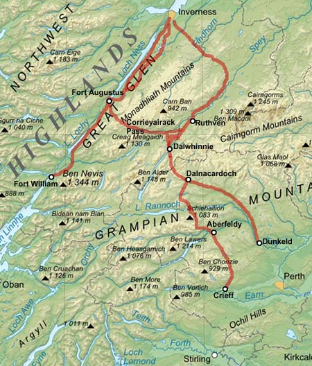
To link these he planned for a road along the Great Glen
linking Fort William and Inverness. From Dunkeld a road
would run up to Dalwhinnie where it would branch to Inverness
and Fort Augustus. It would be joined by another road
from Crieff at Dalnacardoch some miles short of Dalwhinnie.
Work did not start on a Bernera road until 1755.
Working Methods
The roads themselves were sixteen feet wide although in
practice they were often narrower. They were constructed
of layers of progressively smaller stones with a topping
of compacted gravel. If the ground was marshy, a cutting
was made to see if firmer ground could be reached; if
not, brushwood and timber were used
 |
| Military road between Crieff
and Aberfeldy |
as a foundation for the road. The earth removed in forming
the road was piled on either side, forming banks, and
ditches were dug on the outside of these for drainage.
Cross-drains were used if there was a slope. The roads
were constructed as straight as possible and included
some steep stretches. When the gradient became too severe,
zig-zags were employed.
The working parties usually consisted of 100 men and they
would work from the start of April to the end of October.
Wade treated the men well and arranged for them to be
paid more than ordinary soldiers. They stayed at camps
sited ten miles apart and inns or "King’s Houses" often
developed at these locations.
By the end of his tenure Wade had completed some 250 miles
of road and 40 bridges. When he left in 1740 Major Caulfield
was appointed to carry on with the programme of road building.
Wade went on to become a Field Marshal and commander of
British forces in Flanders, at that time fighting the
French. His final involvement with the army was in 1745
when he failed to stop the Jacobite forces marching to
London and to intercept them when they retreated. He died
three years later.
Note: See Burt's Letters for interesting
information about the roads (Volume
2, Letter XXVI). See
also the National
Library of Scotland website for military maps of the
period. General references
for the military roads can be found here.
The Roads
Fort William to Inverness
 |
 |
| Fort William to
Fort Augustus |
Fort Augustus to
Inverness |
Initially this road was built between 1725-1727. It
ran on the south side of the Great Glen and linked Fort
William with Fort Augustus and Inverness. It soon became
apparent that the section between Fort Augustus and
Inverness was difficult to traverse in winter and bad
weather, so a major realignment was carried out in 1732
when a new road was built closer to Loch Ness. Major
features on the Great Glen route were the cuttings at
Black Rock, over a mile in length, on which blasting
was used, and the High
Bridge (over the Spean) which was 280 feet in length
- see image on 1745
Association website.
Canmore
records
Dunkeld to Inverness
(Dunkeld - Dalnacardoch)
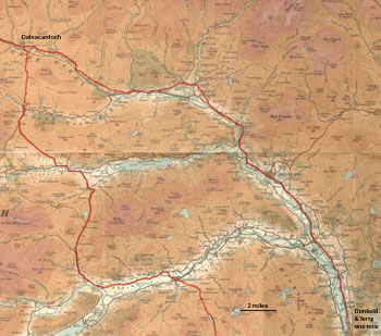 |
| Dunkeld to Inverness
(Dunkeld-Dalnacardoch) |
This was built between 1727 and 1730. Wade decided
on Dunkeld as the starting point as the existing road
between Perth and Dunkeld was sufficiently good. At
the time there were two ferries over the Tay at Dunkeld
which had replaced the mediaeval bridge which had been
destroyed by floods, probably in the 1590's (see Christopher
R Ford, Dunkeld: Telford's Finest Highland Bridge, Perth
& Kinross Libraries, 2004).
Wade seems to have considered building a bridge here
but difficulties with the Duke of Athol led to him to
select Aberfeldy on the Crieff to Dalnacardoch road
as the location for a bridge - see Visit
Dunkeld website.
For much of its length the road is identical to the
old A9, which itself was formerly turnpiked. There are
several stretches where original sections of the road
can be accessed (other than the old A9) and details
of these can be found in Taylor and other writers. The
map used on this site shows the old A9. It is advisable
to consult an up to date map as there have been major
changes to the A9 in recent years.
Dunkeld to Inverness
(Dalnacardoch - Inverness)
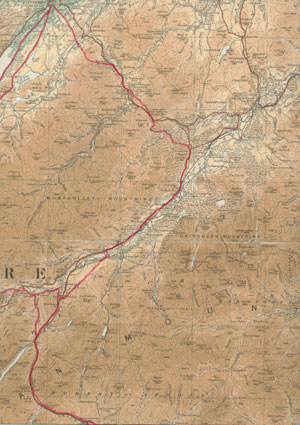 |
| Dalnacardoch to Inverness |
Again the road is identical or very close to the old
A9 in many parts. There are however three notable deviations
from this line. One is from Crubenmore, north of Dalwhinnie,
to Ruthven barracks which would also have served as
a link between Ruthven and Fort Augustus. Another is
the stretch of several miles passing to the west of
Carrbridge as far as the Slochd. Finally there is a
long stretch from Loch Moy to Inverness; interestingly,
part of this route is followed by the new A9 road.
It is worth noting that there were two early routes
from near Blair Atholl over to the Spey valley. These
were Comyn's road and the Minigaig. The Minigaig route,
which appears on Greene's map of 1689, was used by soldiers
to reach the barracks at Ruthven (built in 1719). Wade
decided on the Drumochter Pass as it was lower and less
likely to be snowed in in winter.
The Fort Augustus road via the Corrieyairrack Pass
left the Inverness road at Dalwhinnie. Features of interest
on this stretch are the Wade Stone that can be seen
just past Dalnacardoch and Oxbridge where Wade treated
the men to a feast.
Canmore
records
Crieff to Dalnacardoch
 |
 |
| Crieff to Aberfeldy |
Aberfeldy to Dalnacardoch |
In Wade's time there was an existing road between Crieff
and Stirling which he must have thought was adequate
as the new road was to start at Crieff. Work began in
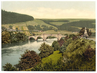
1730. The route incorporated the notable bridge
over the River Tay at Aberfeldy which was built in 1733.
In the early 1740's the road between Stirling and Crieff
was improved under Caulfeild.
Canmore
records
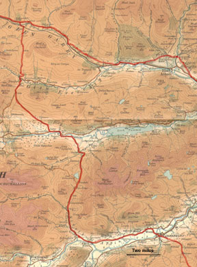
Dalwhinnie to Fort Augustus (Corrieyairack
Pass)
 |
| Dalwhinnie to Fort Augustus |
This road was built in 1731 by working parties totalling
just over 500 men. It was 28 miles in length and climbed
to a height of 2543 ft over the Corrieyairack Pass.
North of Dalwhinnie there was a linking stretch of road
that served as a short cut to Ruthven barracks. It is
a popular recreational route today.
Canmore records
Pdf
leaflet - Highland Council
Note: Overviews of the Caulfield
roads and the Portpatrick road will be added in due
course
|