|
 The
charters examined so far have thrown up a few interesting
roads. The
charters examined so far have thrown up a few interesting
roads.
Those
for Aberdeen give a complete picture of streets in both
Old and New Aberdeen in the middle ages.
Various
sources show that there was a road from Aberdeen to
Kintore and that part of this road still exists on Tyrebagger
Hill. Just south of here the Cryne Cross Mounth forded
the Dee at Durris church and made its way northward
as the Couper or Coupar's Road, a "coupar"
being a cattle or horse dealer. A charter for Drumoak
parish may refer to this road - as it forms a parish
boundary hereabouts it was clearly very old.
A
charter for Turriff refers to a "Monk's road"
and a via regia to King Edward. One for episcopal territories
in Ellon parish mentions a "mercat gate" and
two others refer to roads south west of Ellon. A couple
of fords near Udny probably relate to local routes;
one certainly gave access to the local church. Two charters
for Fyvie and Rayne suggest local routes and a road
is mentioned in New Deer parish but is untraceable.
In Drumoak there was a "sledegat" and in Birse
there were rights of pasture.
Just
west of Bennachie there were two "king's highways"
and a road running up onto Bennachie itself. At Leslie
just north of here there was a road running from the
old parish of Rathmuriel - the fair here used to be
held at night and a "Sleepytown" still exists
as a placename. It probably intersected a long-distance
route to Huntly and the north that ran past Wardhouse
castle. In New Machar parish a "road to the mountains"
is mentioned. It is some 3 miles from a "road to
the north" in Bourtie but it is not known if they
were connected.
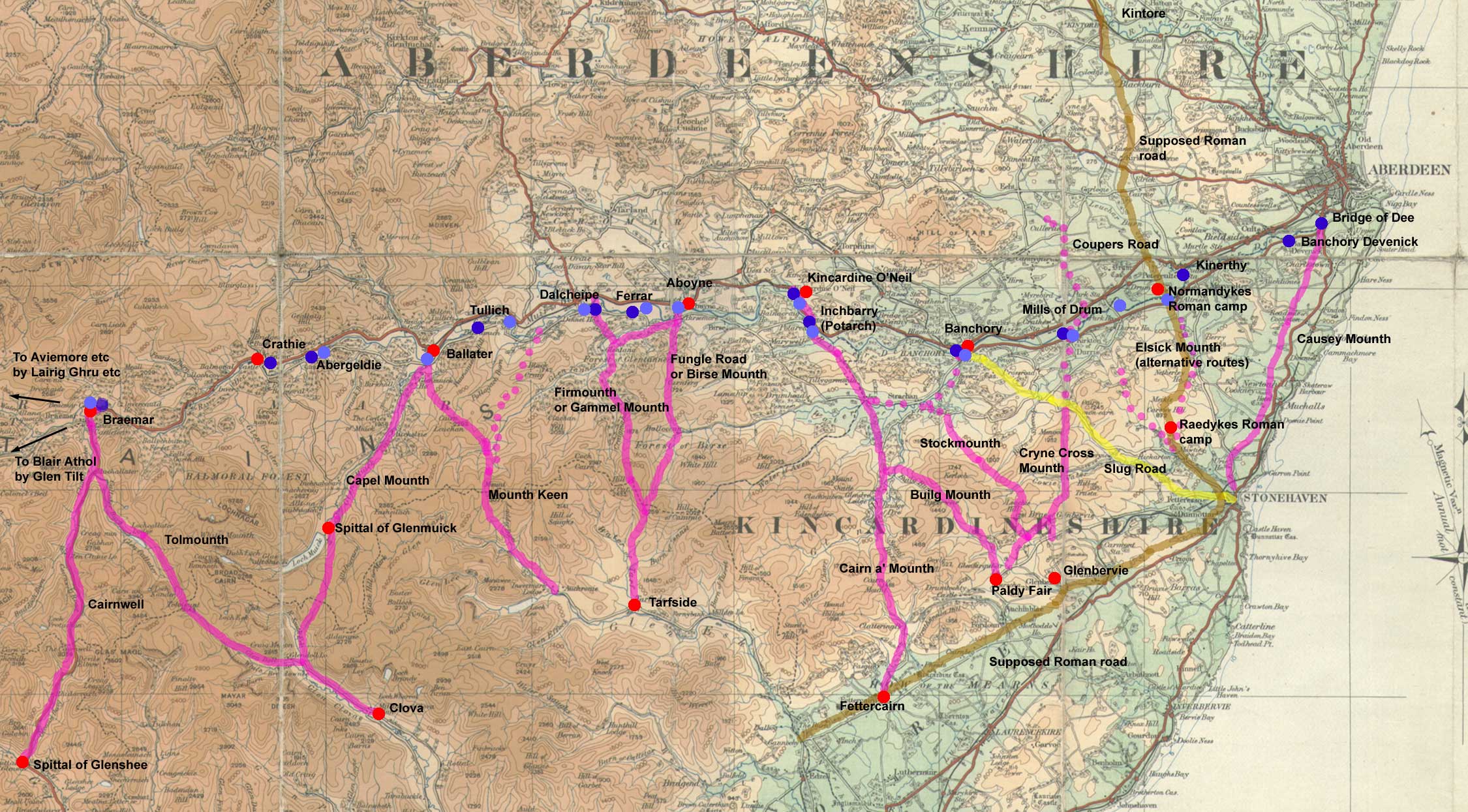
One
important set of routeways was the Mounth passes. The
Mounth was mountainous terrain that ran from the Braemar
area south of the River Dee to the coast near Aberdeen.
There were at least 11 of these routes, spaced every
few miles and crossing the Dee at fords and ferries.
They were much used by drovers and by seasonal workers
travelling to the south.
These
are just those references found in the charters looked
at so far. Edward the First's Itinerary indicates a
network of usable routes in Aberdeenshire, the Laurence
Road must date from this time, merchants from Aberdeen
used to travel to a major fair in Keith
and the Bridge of Don in Aberdeen must indicate a major
route to the north.
Further
details of charters pre-1314 can be found on the PoMS
website.
Amanda Beam, John Bradley, Dauvit Broun, John Reuben
Davies, Matthew Hammond, Michele Pasin (with others),
The People of Medieval Scotland, 1093–1314 (Glasgow
and London, 2012) www.poms.ac.uk.
Aberdeen
Roads and Streets
Aberdeen
developed on the land that lay between the rivers Dee
to the south and the Don to the north, near their mouths.
The rivers here were about two miles apart.
 Originally
there were settlements on each of these rivers, both
well established before the middle ages. The one to
the north was originally known as the Kirktoun of Aberdon
and later as Old Aberdeen, that on the Dee was known
as Aberdeen and was made a burgh by David I. It became
known as New Aberdeen, not in distinction to Old Aberdeen
but to mark its re-building after being sacked by Edward
III in 1336. It was after this time that the Kirktoun
of Aberdon became known as Old Aberdeen to distinguish
it from New Aberdeen. Originally
there were settlements on each of these rivers, both
well established before the middle ages. The one to
the north was originally known as the Kirktoun of Aberdon
and later as Old Aberdeen, that on the Dee was known
as Aberdeen and was made a burgh by David I. It became
known as New Aberdeen, not in distinction to Old Aberdeen
but to mark its re-building after being sacked by Edward
III in 1336. It was after this time that the Kirktoun
of Aberdon became known as Old Aberdeen to distinguish
it from New Aberdeen.
Old
Aberdeen was the site of the old cathedral and of the
chanonry where the canons lived in small houses with
attached gardens; at a later date a merchant area grew
up around the Town House, as well as early buildings
of the university.
New
Aberdeen was the larger of the two settlements and had
a castle, a port, a regular market with extensive trading
privileges, a leper hosital and other establishments
that made it one of the most important towns in mediaeval
Scotland.
The
two settlements did eventually merge as legal entities
in the 1800's but were physically joined long before
then.
Many
early documents have survived that record details of
the two settlements in the middle ages. Among these
are those collected in the Register
of the Bishops of Aberdeen (Registrum Episcopatus
Aberdonensis) and those in the Chartulary
of the Church of St Nicholas in Aberdeen (Cartularium
Ecclesie Sancte Nicholai Aberdonensis). The
Records of Old Aberdeen cover the later middle ages.
These
give valuable details of the streets in Old and New
Aberdeen as well as of the general topography. However,
rather than look at each of the many documents that
list roads it is much easier to note those roads listed
in the indexes of the first two publications (of which
there are in fact only a few) with the charters in which
they occur and at Robert Gordon's map
of Aberdeen published in 1661 which shows all the
roads and streets very clearly - it is highly unlikely
that the road network he shows had changed much since
the period of the 1300's and later which the charters
deal with. This map can be usefully supplemented with
that of Old Aberdeen shown in The Records of Old Aberdeen
(page
256)
- a modification of this map (Aberdeen
City Council site) shows further details of the
Chanonry in Old Aberdeen.
The
roads mentioned in the Register
are: boulgate, castlegat (vico castri), chakkaraw, gastraw,
galowgat, le greyn, Hedraw, hucsterrawe, merkat gate,
newraw, owerkirkgat, ratowne-raw , schipraw, thevis
brig, vicus furcarum, pons de don 227, pons de polgowny,221
& v.II, p.294, thevis brig 332. There are also many
instances of the term via regia though these are not
noted in the index. Locations include Futy or Footdee,
Dronydonis hil, and the Girthcorse (this marked the
area of sanctuary for the cathedral).
Those
mentioned in the St
Nicholas chartulary are: Castle
Street, Chackraw, Gallowgate,The Green, Gastraw, Shiprow,
Upper Kirkgate. It too has many mentions of the king's
highway.
The
Register of Arbroath has two charters that refer to
a vico fraxini, the Kirk brig and the kirkgate.
Vol. 1, Charter 140, page 98, viz. from a bridge called
the kirkbrig by which one can go from the vico fraxini
to the church of the blessed Nicholas and which is sited
between two streams which split at the said bridge as
far the former house of Henry the miller
videlicet a ponte per quem sit transitus
a vico fraxini vsque ad ecclesiam beati Nicholas / qui
vocatur kirkebrig /et que sita est inter duos riuulos
qui bifurcantur a dicto ponte vsque ad domum que fuit
Henrici molendinarij
Vol.1, Charter 269, page 203(?) ….in vico que dicitur
kiregat in villa de Abirden/iacentem inter pontem
iuxta ecclesiam sancti Nicholi ex parte boreali ex parte
una/et terram Rogeri clerici ex parte australi/ ex altera….
….in the street called Kirkgate in
the town of Aberdeen lying between the bridge next to
the church of St Nicholas on the north side, on the
one hand, and on the other, the lands of Roger the clerk,
on the south side….
Another charter (Vol.2, page 117, charter 134) refers
to the common kings highway.
Of roads going outwith Aberdeen the REA has a charter
that relates to the sale of two crofts in 1362 by Robertus
de Berevyk, a burgess of Aberdeen, to Ade Pyngil. These
lay between the end of the forked street from the western
part of the king's highway that runs from Aberdeen towards
the burgh of Kintore..... (REA,
p.103 - see also p.105 which refers to the same two
highways). See
also Wine Causeway below.
"...ad
finem vici furcarum ex occidentali parte vie regie qua
itur a burgo de Aberden versus burgum de Kintor..."
Bridges
The well-known bridges over the Dee and the Don as well
as the Thieves Bridge are noted below. A number of other
bridges are mentioned in The Doric Columns website here.
Bridge of Balgowny (River Don)
Construction
began in the late 1200's and the bridge was completed
by 1320. It is thought to have been commissioned by Bishop
Cheyne or Robert the Bruce. It was renovated in 1605 and
replaced in 1830 by another bridge 500 yards downstream.
It provided an important link to the north-east of Scotland.
See here
(The
Doric Columns website) for further details.
Bridge of Dee
A bridge over the Dee had been long proposed to replace
a dangerous ford but it was not until the early 1500's
that one was commissioned by Bishop William Elphinstone.
It was completed by 1527 by his successor Bishop Gavin
Dunbar, who made a gift of his estate of Ardlair, the
rents of which were to be applied to the upkeep and repair
of the bridge (Reg.Episc.Aber. p. 393). The bridge is
still in use today.
See here
(The Doric Columns website) for further details.
Thieves Bridge
REA,
page 332 A charter of Andrew Ancroft mentions the Thevisbrig
or Thieves Bridge - this crossed the Powcreek Burn between
the Castlehill and the Gallow Hills. It was so called
because it was crossed en route to the gallows - see here
for details. In a charter on page 221 it is called ponte
latronum.
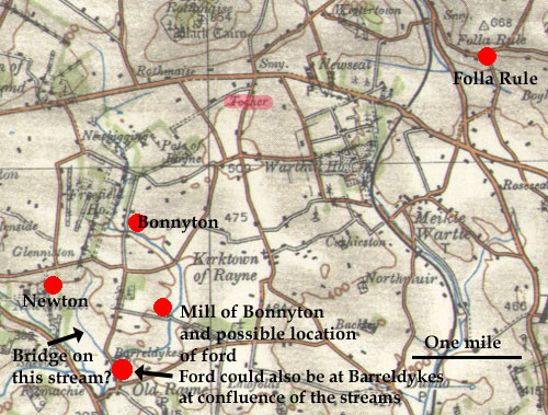
Parish
of Rayne
Agreement on the land of Threpland
Registrum Episcopatus Aberdonensis (REA), p.26
This agreement, dating from 1259, concerned a dispute
between the Bishop of Aberdeen and the abbey of Lindores
about "a certain land called Threpland between the
land of Boyndington which belongs to the said bishop and
the land of Newton which belongs to the said abbot and
community and which begins at the ford of Gethyn which
is from the western part of Boyndington and extends from
the same ford by the river of Gethyn northwards as far
as a certain large syke called Fulleche and by the same
syke ascending towards the west as far as a certain bridge
which is beyond the same syke towards Neutoun and so descending
from the same bridge by the same syke in a circuit as
far as the foresaid ford of Gethyn." These lands
are in Rayne parish.
Compositio
super terra de Threpland
"... super quadam terra que dicebatur threpland
inter terram de Bondyngton que est dicti episcopi et terram
de Newton que est dictorum abbatis et conventus et incipit
ad vadum Geythyn quod est ex parte occidentali de Bondyngton
et extendit se ab eodem vado per eundem rivulum de Gethyn
versus boream usque in quendam magnum sichum qui dicitur
Fulleche et per eundem sichum ascendendo versus occidentem
usque ad quendam pontem qui est ultra eundem sichum versus
Neutoun et sic descendit ab eodem ponte per eundem sichum
in circuitu usque in predictum vadum de Gethyn."
Interpretation
 Despite
its apparent clarity there are uncertainties about this
document that make it difficult to identify the ford
and the bridge with their implied routes. Despite
its apparent clarity there are uncertainties about this
document that make it difficult to identify the ford
and the bridge with their implied routes.
One
uncertainty is of the location itself. Alexander Laing
in Lindores Abbey and its Burgh of Newburgh says
on page
162 that it was to the west of Newburgh (Fife) although
he says the places can no longer be identified. A more
likely location is in the vicinity of Old Rayne where
both the bishop of Aberdeen and Lindores had possessions
and where there is a possible fit with placenames.
On
this reading Bondyngton would be Bonnyton and Newton
could be Newton to the west of Bonnyton; by definition
Threpland (disputed land) would lie in between. Fuleche
as a name is very close to Folethrowle, now Folla Rule,
which is between 2 and 3 miles north of Bonnyton (see
p.110 below) and is very close to the parish boundary
here that runs along a water course.
There
is a stream to the west of both Mill of Bonnyton and
Bonnyton which if followed northwards and then westwards
leads to another stream that flows down to meet the
original stream - this could conceivably fit the wording
(though Folla Rule would be too far to the north). This
would allow us to place the ford and the bridge on both
streams though with only a hint of where the associated
tracks would have run. Barreldykes would also fit the
wording as the location of the ford.
Note
the placename "tocher" at the top centre of
the map which means causeway or road.
Parish
of Turriff
Turriff
Carta fundationis terre ecclesiastice ville de Turreff
continens limites ejusdem
(REA,
p.30)
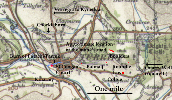
The church at Turriff was passed over to Arbroath Abbey
by Marjorie Countess of Buchan as noted in a charter
of William I dated 1213 that confirmed grants to Arbroath.
There was an earlier Celtic monastery in Turriff but
it is not clear if it was this along with its lands
that were passed to Arbroath. In any event Marjorie's
son Alexander, Earl of Buchan, set up a hospital at
Turriff and passed over the rights he had to the church
lands in Turriff. These are described in Alexander's
charter, dated 1272, as follows:
".....namely between the said land of Kinarmy from
the southern part as the river descends in Parcok which
is called Putachi and so as the Parcok runs into the
water of Doverne and so by the Doverne as far as the
stream between Auchinfoight and Cnocky from the western
part which is called Cnockiburn and so ascending by
the same rivulet as far as the ford at the head of the
said rivulet called Hacracky and so from that ford by
a syke descending to the ford of Tulkillj and so descending
from that rivulet to the stream quarellj (colloquially?)
called Sulhok and so returning from that stream as far
as the standing stones that divide Colpie and Kacukj
and so returning by a certain hill as far as the standing
stone of Balmalj and Cokukj and so from that stone to
the road of the monks and so by that road ascending
to the divisions made by plough descending to the via
regia between Kyneduart and Turrech and so by that road
descending as far as the eastern part of the meadow
and so descending to the rivulet of Putachi...."
Original
text below
For further details about the monastery
see Turriff page on this website on the early Celtic
church here,
also Notice
of the Church of St Congan at Turriff, John Stuart,
PSAS 1866, and Canmore
record.
Interpretation
 Those
places that can still be identified are marked on the
map. From Kinarmy one would go to the Putachi Burn which
runs through Turriff near to the old church then up
by the Dovern to Knockiemill, presumably Cnockie then
up the stream there. There is a ford called Dubhford
that may be Hacracky, or Hacracky may be nearer the
head of this stream. Tulkillj is lost but quarellj/Sulhok
may just be Quarry Well on the present day Burn of Colpie
south oquially, i.e. the stream commonly called Sulhok.
of Delgaty Castle - or it may even be that quarelli
means coll Those
places that can still be identified are marked on the
map. From Kinarmy one would go to the Putachi Burn which
runs through Turriff near to the old church then up
by the Dovern to Knockiemill, presumably Cnockie then
up the stream there. There is a ford called Dubhford
that may be Hacracky, or Hacracky may be nearer the
head of this stream. Tulkillj is lost but quarellj/Sulhok
may just be Quarry Well on the present day Burn of Colpie
south oquially, i.e. the stream commonly called Sulhok.
of Delgaty Castle - or it may even be that quarelli
means coll
The
2nd edition of the 6"OS map shows stones in this
area (shown as small red dots on the map) that could
be the ones referred to and the "certain hill"
might be Roundel Law. Whatever the case, the wording
suggests the monk's road was somewhere near Balmalj
though not where it was leading. It is hard to say if
the road had been formed at the time of the Celtic monastery
or by Arbroath though it is likely enough to have been
to an outlying part of the territory as defined by the
boundaries noted above.
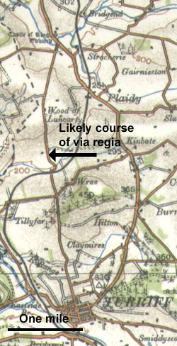
The
via regia is very likely to be the same road as that
shown on the Military Survey map (now the minor road
running north out of Turriff) both because there is
a reasonable fit with the wording of the charter and
it is the shortest and most direct route to King Edward.
Carta
fundationis terre ecclesiastice ville de Turref continens
limites ejusdem
"....scilicet inter dictam terram et Kinarmy ex
parte australi sicut riuulus descendit in Parcok qui
vocatur Putachi et sic sicut Parcok descendit in aquam
de Douerne et sic per Douerne usque ad riuulum inter
Achinfoight et Cnocky ex parte occidentali qui dicitur
Cnockiburn et sic ascendendo per illum riuulum usque
ad vadum in capite dicti riuuli nomine Hacraky et sic
de illo vado per vnum siketum descendentem vsque ad
vadum de Tulkillj et sic descendendo de illo riuulo
vsque ad riuulum quarellj nomine Sulbok et sic redeundo
ab illo riuulo usque ad lapides stantes in diuisis inter
Colpie et Kakukj et sic redeundo per quendam collem
vsque ad lapidem stantem de Balmalj et Cokukj et sic
ab jllo lapide vsque ad viam Monachorum et sic per illam
viam secundum diuisas factas per aratrum descendendo
in via regali inter Kyneduart et Turrech et sic per
illam viam descendendo usque ad orientalem partem prati
et sic descendendo vsque ad riuulum de Putachi..."
(back)
Parish
of Newhills
Carta Regis Roberti super foresta de Cordys Jacobo de
Garviach militi concessa
Memorandum quod carta sequens hic scribitur ad finem et
effectum ut cognoscantur mete seu limites terrarum de
Clyntre episcopi
(REA,
p.43)
Grant
by Robert the Bruce of the Forest of Fordyce to a Sir
James Garviach, 1316 and noting the boundaries of the
bishop's lands of Clinterty.
The
section of interest is as follows: "...namely,
beginning at the ford called Achinacragoc and so descending
by the river as far as the mill of Kinaldy and so from
the northern part of the said forest descending to two
large standing stones below Thorrynadac and so descending
to Polnacroscell and descending next to the water of
Done as far as the shaws of Alton of Fyntraff and so
descending by a path to the well/fountain called Tubirnacrag
and so ascending to Schencragoc and from thence to Carenlech
and from Carenlech to the stream called Aldenacloch
and so descending to Carenleth next to the kirkton of
Dys and so descending by the path which leads to the
said village of Dys as far as a font/well at the entrance
to the village and to another font in the middle of
the village and so from the east side of the aforesaid
forest by the king's highway that leads from Aberdeen
to the well called Tubirnadaly and thence to the ford
called Achynnafonee and thence to the ford called Achynaterman
then from the south side of the said forest by a path
leading as far as Gelcaren next to the village of Huttereny
and from there by a Reske (rough unproductive land -
see definition
of "risk" on Records of the Parliaments of
Scotland site) to a cross (Canmore
entry) and great stone on the king's highway next
to Huttereny from the west side of this village descending
to the river called Aldynalene and so ascending by the
river to the head of the river of Glenconan and so ascending
to the summit of the mountain called Cragnathybo and
so descending to the river of Glenyn and so by the said
river to the ditch which leads to a recumbent stone
(see Cruikshank) and so ascending by the same ditch
to the head of the wall of Clenterret bishop ("Bishop's
Clinterty") and so passing in a circuit by the
said wall to an old cart road which leads from the village
of Clentrethi herhard and leads next to the marshy lake
as far as the font/source under the Crag of Clentrethy
(now Clinterty) and so from the said source as far as
Achinacragoc where we began." (original
text below)
Interpretation
 |
| The
line of the mediaeval and, for the most part, the
pre-turnpike road is shown in red. For details of
the Bishopton area see Cruikshank's paper below
- this includes a map and illustrations. |
This
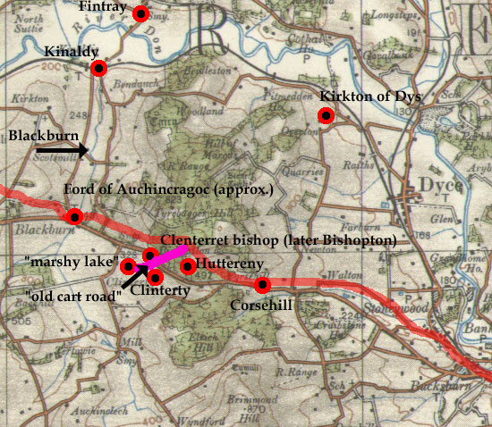
was a grant by Robert the Bruce of the Forest of Fordyce
to a Sir James Garviach in 1316, and which noted the
boundaries of the bishop's lands of Clinterty. Although
a number of the placenames are lost it is clear enough
that the forest was in the vicinity of Tyrebagger Hill
and the Hill of Marcus that lie between Aberdeen and
Kintore.
We
can trace the western boundary along the Blackburn up
to the river Don at Hatton of Fintray. The next identifiable
place is the Kirkton of Dyce that lies about a couple
of miles NNW of present day Dyce. The east side of the
grant is obscure but we can pick it up again on the
south side by the reference to Huttereny which is close
to the cross and great stone on the king's highway that
still exist. The Clenterret bishop of the charter or
Bishop's Clinterty, as we would style it, is now Bishopton
and we can presume the boundary would have ran up to
the Blackburn and its ford of Achinacragoc where the
circuit began.
The
charter refers to various fords as well as a couple
of roads, as follows:
- the
ford called Achinacragoc
- path to the well/fountain called Tubirnacrag
- path which leads to the said village of Dys
- the king's highway that leads from Aberdeen to the
well called Tubirnadaly and thence to the ford called
Achynnafonee and thence to the ford called Achynaterman
then from the south side of the said forest by a path
leading as far as Gelcaren next to the village of Huttereny
- cross and a great stone on the king's highway next
to Huttereny
-
old cart road leading to a marshy lake.
The
first three of these are lost although a rough idea
of their location can be estimated; they seem no more
than local. There is a slight ambiguity in the fourth
extract where it is not quite clear if the kings highway
is on the east side or the south side of the forest
though "the kings highway next to Huttereny"
is clearly on the south side. At this point we can be
sure of the location as the cross, great stone and recumbent
stone have been identified and are discussed in an interesting
paper, viz. Newhills
Cross, Aberdeenshire by James Cruikshank (PSAS,
Vol.60, p.269-273, 1926).
In
this paper he describes these (intended to mark the
boundary of the bishop's lands) and identifies the wall
(presumably a dry-stone wall). Interestingly the bishop's
land is marked by the old parish boundary which at this
point cuts up towards Tyrebagger Hill. What is significant
here is that the king's highway is said to be beside
the cross and great stone. Cruikshank was able to identify
it saying that it was "less than six feet wide,
has a solid, well-preserved bottom, and is almost level
the whole way, being formed as a kind of shelf in the
brow of the hillside." It is very likely that the
course of this old road is shown (in this locality)
by the parish boundary.
The
cart road would have ran the very short distance from
the vicinity of Bishopton to the marshy ground near
Broombank, identified as where some prehistoric finds
were made in 1897 - see 2nd edition 6" map.
The
latest note on the Canmore entry suggests that the cross
had been misidentified and was in fact to be found in
the area of Corsehill to the east. Even if this is the
case, it does not negate Cruikshank's remarks about
the mediaeval road and the route it took.
Cruikshank
refers to an 18th century road below the mediaeval road,
and the turnpike below that again. Thomas Day in Construction
of Aberdeenshire's first turnpike roads (Journal
of Transport History, Sept. 2003) notes that the
turnpike was opened in 1800 and that before that, road
improvements had been carried out not just by parishes
but in the case of the Kintore and Inverury road by
the Commissioners of Supply who in 1739 made local landowners
on the line of this road responsible for stretches near
their estates (p.156). It is interesting to see that
a stretch of the Kintore road had been worked on by
the military - it runs very directly from above Kinellar
House towards Kintore (6" OS map - Aberdeenshire,
LXV). Taylor discusses this in The Military Roads
in Scotland, page 91/92 and dates it to the 1760's.
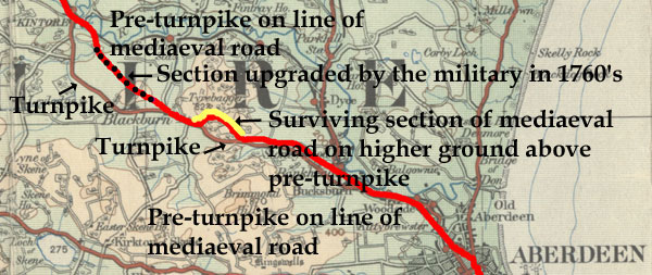
While it is interesting to note that a section of the
mediaeval road to Kintore has survived, the question
arises as to what course it took over the whole distance,
and how close this was to the turnpike or 18th century
line. Although the line of the turnpike road is very
clear, being shown on recent maps before current improvements
to the A96, that of the 18th century road is less so.
One ambiguity is at the Aberdeen end where the military
survey (c.1750) shows it south of the river that runs
past Craibstone and Bankhead, whereas the early OS maps
suggest it ran west of Bankkead by the minor road as
far as Corsehill. From here it seems to have run just
north of the turnpike to Blackburn and then by the straight
military road stretch to Kintore though even here the
maps can be difficult to interpret.
With
these factors in mind, a possible course for the mediaeval
and 18th century road is shown on the map - these roads
were likely to have had much the same course with the
exception of the earlier road being visible on Tyrebagger
Hill. Given that there was a road between Aberdeen and
Kintore from early in the middle ages, and that tradition
tells of a "Wine Causeway" between these places
there can hardly be any doubt that this was one and
the same road.
Carta
Regis Roberti super foresta de Cordys Jacobo de Garviach
militi concessa
- Incipiendo videlicet ad vadam que vocatur Achinacragoc
et sic descendendo per riuulum usque ad molendinum de
Kinaldy et sic ex parte boreali foresto predicte descendendo
ad duos magnos lapides sub Thorrynadac et sic descendendo
vsque Polnacroscell et descendendo iuxta aquam de Done
vsque le schawes del Alton de Fyntreff et sic descendendo
per semitam vsque ad fontem qui vocatur Tubirnacrag
et sic ascendendo vsque Schencragoc et deinde vsque
Carenlech et a Carenlech vsque ad riuulum qui vocatur
Aldenacloch et sic ascendendo vsque Carenleth iuxta
le kirkton de Dys et sic descendendo per semitam que
ducit ad dictam villam de Dys vsque ad fontem in introitu
ville predicte et ad alium fontem in medio dicte ville
et sic ex orientali parte predicte foreste per viam
regiam que ducit apud Abirden vsque ad fontem qui vocatur
Tubirnadaly et abhinc vsque ad vadam que vocatur Achynnafonee
et abhinc vsque ad vadam que vocatur Achynaterman et
abhinc ex australi parte foreste predicte per semitam
ducentem vsque Gelcaren iuxta villam de Huttereny et
abhinc per vnam Reske usque ad crucem et magnum lapidem
in via regia iuxta Huttereny ex occidentali parte dicte
ville descendendo vsque ad riuulum qui vocatur Aldynalene
et sic ascendendo per riuulum vsque ad caput riuuli
de Glenconan et sic ascendendo vsque ad summitatem montis
qui vocatur Cragnathybo et sic descendendo ad riuulum
de Glenyn et sic per dictum riuulum vsque ad foueam
que ducit ad magnum lapistratum et sic ascendendo per
eandem foueam vsque ad caput muri de Clenterret episcopi
et sic transeundo in circuitu per dictum murum vsque
ad veterem viam plaustrorum que ducit de villa de Clentrethi
herhard et ducendo iuxta lacus maresij vsque ad fontem
sub le Crag de Clentrethy et sic de dicto fonte vsque
Achinacragoc vbi inceperunt." (back
to translation)
Parish
of Fyvie
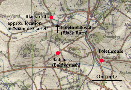
Folethrowle
(REA, p.110 -see also page 174)
Donatio Ade Pyngle burgensis de Aberden
terrarum de pro sustentatione vnius capellani in ecclesia
beate Marie de Aberden 1376
 In
this charter there is mention of a mill at Folethrule,
the lands of Folethblakwatre, and of a portion of land
between the stream called Folethblackwatre and the road
of Garlet. There is also a mention of a Blakfurde and
Badchass in the vicinity. In
this charter there is mention of a mill at Folethrule,
the lands of Folethblakwatre, and of a portion of land
between the stream called Folethblackwatre and the road
of Garlet. There is also a mention of a Blakfurde and
Badchass in the vicinity.
"...et
cum illa petia terre arabilis iacente in terris de Folethblakwatre
inter dictum riuulum et viam del Garlet...."
Interpretation
These locations lie in the parish of Fyvie about 8 miles
NNW of Inverurie. Folethrule is Folla Rule, Foleth-blackwatre
is the Black Burn, and Blackford and Badchass (Baldyquash)
still exist. Garlet as a placename has not survived
but the text suggests that the road ran parallel to
the Black Burn.
Fyvie
Castle - Stanyford
(Registrum
de Aberbrothoc Vol.1, Page 310, No. 353, 1325)
This
recorded a perambulation of the bounds between Ardlogy
and Fyvyne, thus:
…beginning at the lower end of the motherlech (a
marshy area from which various streams arise) which
is called Greimos and so proceeding and placing marks
between the petary of Ardlogy and the petary pertaining
to the park (of Fyvyne) until coming near the Stanyford
incipiendo
ad inferiorem finem de le Modirlech qui vocatur Greimos
et sic ambulando et signa ponendo inter petariam de
Ardlogy et petariam pertinentem ad parcum quousque peruenerant
apud le Stanyford
Interpretation
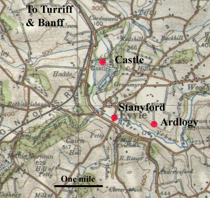 In
a paper dealing with Fyvie Castle, (Fyvie
Castle, PSAS, Vol 73 (1938-39), 32-47) W Douglas
Simpson identifies the Stanyford as being just south
of Fyvie over the Ythan. In the middle ages the castle
was defended on north and west by the river and marshy
ground to its east. The only approach from the south
led over this ford to a strip of land only 500 feet
wide running past the castle (page 35). In
a paper dealing with Fyvie Castle, (Fyvie
Castle, PSAS, Vol 73 (1938-39), 32-47) W Douglas
Simpson identifies the Stanyford as being just south
of Fyvie over the Ythan. In the middle ages the castle
was defended on north and west by the river and marshy
ground to its east. The only approach from the south
led over this ford to a strip of land only 500 feet
wide running past the castle (page 35).
Parish
of Methlick
Carta terre ecclesiastice de Methlaych (REA,
p.112 - see also page 114)
This charter refers to a piece of land that on one side
lies immediately next to the water of Ethoyn called the
haugh, and on the other descends to the ford over the
Melok as far as the ford called Clochy.... 1365
"quamdam peciem terre iacentem immediate iuxta aquam
de Ethoyn que vocatur le haulch ex parte vna et descendendo
a vado riuuli de Melok vsque ad vadum quod vocatur Clochy
ex parte altera..."
Interpretation
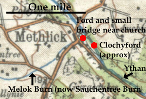 This
location is near the old church of Methlick as shown
by the following quote from the New Statistical Account
for Methlick parish (Vol.XII,
page 973), viz. "Robert II....confirms a charter....of
a piece of land called the Haulch, bounded on the one
side by the water of Ethyon, stretching, on one hand,
from the ford of the burn of Melok to the ford which
is called Cloy or Clochy on the other. It is probable
that the present glebe is very nearly the piece of land
referred to in the charter just quoted. For it is bounded,
on the one side, by the river Ythan; at one extremity
of it, there is the burn of Methlick, at the entrance
of which, into the Ythan, there was formerly a ford,
now superseded by a bridge, and a little below the other
extremity there is another ford, which is now called
Golyford or Cloverickford, evidently corruptions of
Cloy or Clochyford, the name mentioned in the foresaid
ancient charter." This
location is near the old church of Methlick as shown
by the following quote from the New Statistical Account
for Methlick parish (Vol.XII,
page 973), viz. "Robert II....confirms a charter....of
a piece of land called the Haulch, bounded on the one
side by the water of Ethyon, stretching, on one hand,
from the ford of the burn of Melok to the ford which
is called Cloy or Clochy on the other. It is probable
that the present glebe is very nearly the piece of land
referred to in the charter just quoted. For it is bounded,
on the one side, by the river Ythan; at one extremity
of it, there is the burn of Methlick, at the entrance
of which, into the Ythan, there was formerly a ford,
now superseded by a bridge, and a little below the other
extremity there is another ford, which is now called
Golyford or Cloverickford, evidently corruptions of
Cloy or Clochyford, the name mentioned in the foresaid
ancient charter."
Jarvise
in Epitaphs and Inscriptions from Burial Grounds (V.2,
page 23) says that below the kirk there are "large
stones on both sides of, also stepping-stones across,
the river."
The
burn of Melok must be what is now called the burn of
Sauchentree. Just before it joins the Ythan there is
a small bridge. The Clochyford would have been over
the Ythan a little way downstream.
Parish
of Inverury
 Inverury
(REA, p.286) Inverury
(REA, p.286)
A charter dating from 1464 refers to lands in Inverury
between the via regia on the east and the Keylandis on
the west. Keylandis is now Kellands and can be seen on
the OS 6" map, sheet LIV, Aberdeenshire.
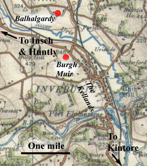
Inverury
- Bridge of Balhaggardy (Balhalgardy)
Charter of Earl John concerning xx. shillings in Inverurie
Chartulary
of Lindores, charter XVII, page 21. Date 1232X1237.
Notes, page 240.
POMS
3/8/9
This
was a grant of Earl John of twenty shillings sterling
per year to be paid initially from rents owed byburgesses
of Inverury for lands between the burgh and the Bridge
of Balhagerdyn.
Interpretation
Balhagerdyn, now Balhalgardy, is two miles north
of Inverurie. There is no bridge shown on early maps
(NLS maps) - whether it had disappeared by the 1600's
when the maps were made, or have still existed but was
not mapped is impossible to say. From the wording of
the charter it is likely that it was over the Urie and
to the north of Inverurie where the burgh muir was.
Parish
of Kintore
Kintore (REA,
p.303 - see also 340, 341, 343)
 Several
charters from the 1490's refer to a via regia in Kintore.
Thus one on page 303 has communem viam regiam and vie
regie, another on page 340 has vici regij and communem
venellam, page 341 has vici regij and communem venellam,
page 343 has vici. The via regia is no doubt the high
street and would have come from Aberdeen and led onwards
to Inverury. The common vennel would be a lane leading
off the high street. Several
charters from the 1490's refer to a via regia in Kintore.
Thus one on page 303 has communem viam regiam and vie
regie, another on page 340 has vici regij and communem
venellam, page 341 has vici regij and communem venellam,
page 343 has vici. The via regia is no doubt the high
street and would have come from Aberdeen and led onwards
to Inverury. The common vennel would be a lane leading
off the high street.
The
Wine Causeway
The Old
Statistical Account for Kintore says that the burgh
had a privilege, now passed over to Aberdeen, of collecting
customs on wine coming into Aberdeen and that there was
a “a causeway at the east end of the freedom of Kintore,
near Kinellar, on the way to Aberdeen, still called the
Wine Causeway, to which it is said, in old times people
came from the harbour to pay custom.”
Alexander Watt in The Early History of Kintore (page
20 and 149) says of the wine causeway that there was
a tradition that it was a Roman road and that it is shown
on the 6" map running up from near Cairntradlin through
Kintore to Inverury. Certainly the 1st edition shows the
supposed line of road north of Kintore but not south of
the town. In any case the putative Roman road was supposed
to come due north from Normandykes which would take it
well away from any route between Aberdeen and Kintore.
A
more likely identification is a very old road mentioned
in an interesting paper by James Cruikshank, Newhills
Cross, Aberdeenshire, (PSAS, Vol.60, p.269-273,
1926) that crosses Tyrebagger Hill and appears to have
been a made road rather than a track. This would merit
it being called a causeway and it is on the direct route
between Aberdeen and Kintore. Further details are given
above.
Parish
of Birse
(REA, p.375)
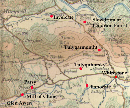 This is an entry in the Rental (dated 1511) of lands
near Aboyne that allows tenants to have common pasture
in the Bradbog and marsh and to come and go with their
animals to the forests of Glenawen and Lendrum (see
page 12 for original grant of the Forest of Birse made
by William the Lion). An entry on the following page
for the mill of Cluny mentions pasture rights and a
way to the forest. There are a number of other entries
in the Rental for this area that mention bondages and
services that would entail travel.
This is an entry in the Rental (dated 1511) of lands
near Aboyne that allows tenants to have common pasture
in the Bradbog and marsh and to come and go with their
animals to the forests of Glenawen and Lendrum (see
page 12 for original grant of the Forest of Birse made
by William the Lion). An entry on the following page
for the mill of Cluny mentions pasture rights and a
way to the forest. There are a number of other entries
in the Rental for this area that mention bondages and
services that would entail travel.
Interpretation
All locations mentioned except for Bradbog and the marsh
(where there was common pasture) are still identifiable
and shown on the map, viz. Tulyquhorsky, Ennochty, Tulygarmontht,
Glenawen, Lendrum, Clune, Parsy, Invercat. From the
wording we can assume sufficient movement from the farms
to form rough tracks leading to the two forests.
There
is an interesting reference to Whitestone and its inn
on the Cairn a'Mounth road, namely, "The quhitstane
at thee mvreaile hous."
Itinerary
of Edward I
Details
of Edward's movements in his campaigns in the north-east
of Scotland during 1296 and 1303.
Parish
of New Deer
 |
| Places mentioned
in the charter. The parish boundary of New Deer
is shown in purple and estate boundaries in the
19th century in green. Although New Deer was formed
out of the old parish of Deer in the 1500's it is
quite likely that the boundary above existed in
the 1200's. |
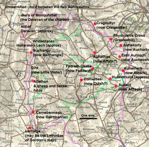
Sometime
before 1211, Fergus Earl of Buchan exchanged three davochs
of land in what is now New Deer parish for the lands
of Slains and Cruden south of Peterhead.
His
charter is of interest because it mentions "the
high road above Clochnuly" as well as a couple
of fords.
At
first glance the charter seems very easy to interpret
because many of the placenames still exist. Indeed some
are almost unchanged. However, although we can get a
reasonable idea of where the fords were, "Clochnuly"
has not survived and its occurence in the charter does
not make it clear where it might have been.
The
map shows the placenames that can be identified as well
as the boundary of the parish and boundaries of estates
as shown on Alexander
Gibb's map of 1858. Estate boundaries are very long
lived and may give a clue to early land divisions.
After
a preamble that details the exchange for Slains and
Cruden, the charter refers to the "Three Daughs
of Feddret (Fedreth), viz., Easter Auchoch (Estir
Auhioch), Atherb (Auhetherb), Auchethad (Auhethas)
and Quiltes (Conwiltes), wholly and without diminution,
as well in length as in breadth, with all their boundaries
and proper divisions, viz., On the East from the rivulet
running on the East side of Easter Auchoch (Estir
Auhioch) as far as the Crooked hollow on the West
side of the Hill of Derevan on the West, and between
the High Road above Clochmerly (Clochnily) as
it extends on the South as far as the Physician's Cross
on the North; and again going up on the East from the
foord of the rivulet of Huskethuire, between Auchelit
(the translation identifies this as Affioch - it is
Auhelit in the original text) and Atherb (Auhitherb),
as far as the rivulet of Gight (Giht) on the
West, and on the foresaid East side from the Foord of
the rivulet between the two Auhcranthis (Auhcrauthis)
as far as the said Water of Gight (Giht), below
the Sheep Cott of Ruther McOan of Allathan (Allethan)
on the West and proceeding in the middle between the
Two Sheep Cotts Southward, as far as the foresaid High
Road above Clochmerly (Clochnuly), and likewise
from the great hollow lying near the Manor of Cairnbanno
(Carnebennach), on the North-West side, extending
to the Water Gight (Giht), as far as the conflux
of the ....... of Lethalge on the North side, and from
the Crooked hollow which is called Hollers Myleth (Holleresky
Lech), lying between Bathangie (Buchangy)and
the hill of Darevan, on the West side of the Darevan,
and likewise from the Dyke at the hollow foord of Auhakerly
(Auhakorty), on the West side as far as to the
North side of Craigcultur (Cragcultyr), and from
Craigcultur to the foresaid Physician's Cross, and from
the said Cross to the North side of the Darevan. (Translation
given in Scottish
Notes and Queries, Vol. VII, 1893/94, page 139).
As some of the placenames are rendered differently from
the original text, the original forms are given in brackets
after each placename.
For original see Collections for a History of the Shires
of Aberdeen and Banff, 1843, page
407.
Also Book
of Deer, page 98
Interpretation
As this is a very difficult charter to interpret
we will restrict comments to identifying placenames.
The main problems are that it is not clear if the charter
describes one continuous boundary or three boundaries
for each of the davochs, and where Clochnily and the
road is located. There are also a couple of places in
the charter where words are missing.
The
placenames of Fedreth, Auhioch and Auhetherb are straightforward
but Auhethas and Conwiltes have not survived. It is
possible that these are Affath and Culsh - the Quilquox
in the south of the parish seems too distant and does
not tally with the boundaries. The rivulet to the east
of Ester Auhioch accords with the parish boundary here
(the parishes of Old and New Deer were formed out of
the old parish of Deer but it is quite possible that
an existing boundary for Fedderet was used for the new
parish in this location) but the Hill of Deveron is
difficult, especially as the river Deveron is far distant.
However, an entry in MacFarlane's Geographical Collections
(Vol.1 page 62) says that there is a place in the north
of the parish called Whitestanes on which the three
rivers of Ythan, Ugie and Deveron arise. In fact the
Little Water (the Gight of the charter) runs into the
Ythan, the Burn of Monquhitter into Deveron and the
North and South Ugie still retain their name. We could
then surmise that the Burn of Monquhitter would have
been thought of at that time as the Deveron and that
the Hill of Deveron would have been a distinct hill
east of the Monquhitter, though exactly which is difficult
to say. The Hill of Corsegight or one north of Balthangie
would be possibilities.
Leaving
the high road aside, J Milne (Place-names in Buchan,
Trans Buchan Fld Club, vol.4, Page 215, 1897) says that
the Physician's Cross may have been on the lands of
Grassiehill and that a carved stone had been found embedded
in a bridge on the old road between New Deer and Strichen.
He also says (p.202) that the ford of the rivulet of
Huskethuire was probably the Fishfur Burn (see map)
- Auhelit (Affleck) and Auhitherb) Atherb are nearby.
The two Auhcrauthis are unidentified.
Allathan
still exists as does Cairnbenno and there is strong
possibility that Lethintae marked on Gordon's map (Lower
part of Bu[quhan]) is the Lethalge of the charter
- it is certainly near the confluence of the Gight with
what must be the Black Burn and which forms the parish
boundary here. Holleresky Lech was no doubt a marshy
place but its exact location, other than it being near
Balthangie, can only be guessed at.
The
remaining placenames are on the east side, and still
exist, i.e. Auchorthie and Cragcultyr along with the
Physicians Cross.
Monymusk
This
charter details lands granted to the Priory of Monymusk
by Malcolm III in 1078. It is of interest as it mentions
two king's highways.
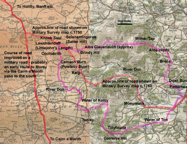 |
| Charter boundaries as determined
by Low, some stretches of which follow parish boundaries.
In one or two places the boundaries are not precise
but the location of the roads at Littlejohn's Length
and on Bennachie is clear enough. Click for larger
map. |
The
marches of the Episcopal lands of Keig and Monymusk
granted to the Church of St. Andrew by Malcolm, King
of Scots, as contained more fully in the charter above
drawn up. Extracted from the Register of St. Andrews
by Mr. Walter Bannantyn. And the said King assigned
to the said Church the said lands by the underwritten
marches and caused them to be reduced to writing.
The
first march begins at the brook which is called Toen
[Ton], so called because a certain woman of the name
of Toen [Ton] was submerged in that brook and drowned,
and so as far as the brook called Kolcy and so by following
from Kolcy as far as the river that is called Don, and
so holding the Don as far as the rivulet towards the
north that is called Fowlesy and so by following from
the Fowlesy as far as Coritobrich, which is interpreted
the valley of the fountain. and from Coritobrith to
Lawchtendaff, which means in Latin, a place where a
man was killed, to the turning point of the four royal
roads, and so towards the east as far as the top of
the mountain that is called Sclenemingorne, which is
interpreted the haunt of goats, and so towards the east
as far as the Standing Stones near Albaclanenauch, which
means in Latin the field of sweet milk, and along the
road as far as the top of the mountain that is between
Keig and the Garioch, and so by dividing the separate
hills into two parts as far as Benachie, namely one
part to the property of the Garioch, and another to
the property of Monymusk. Likewise by dividing Benachie
into one part to the property of Monymusk and another
to the Garioch. And from Benachie as far as Aide Clothi,
which means in Latin the Rocky Rivulet, and from that
place as far as Brecachath, which is interpreted a field
marked by colours, on the right, and from Brecacath
as far as the brook which is called Urcewy, and by following
from the Urcewy as far as Cosalde and from Colsalde
to the head of the wood which is called Trenechinen
which means in Latin Wood extended straight, and towards
the south as far as one fountain from which one rivulet
flows which is called Doeli which means "Carbon" in
Latin owing to its blackness, and so by following from
Doeli as far as the river Don, and from the Don towards
the south as far as the first march which began at the
brook that is called Ton. (Translation from Materials
for a History of the Church and Priory of Monymusk,
(1895), William M MacPherson, p.87)
For original text see Collections
for a history of the Shires of Aberdeen and Banff,
vol. 2-5, p.171
Interpretation
There is a very useful paper on this charter printed
in the Proceedings of the Society of Antiquaries of
Scotland, Vol.6, p. 218, 1865. The paper is by Rev.
Alex Low and is entitled "Notices
of the Localities in a Grant of the Lands of Keig and
Monymusk etc." The boundaries identified by
Low are shown on the map. Some clearly follow parish
boundaries but here and there, particularly east of
Bennachie, some uncertainty creeps in. However, the
place where the four highways (presumably two highways
crossing each other) met can be readily identified as
Littlejohn's Length, a pass lying between Knock Saul
and Satter Hill. The other road mentioned, following
Low, appears to be on Brindy Hill leading up onto the
massif of Bennachie.
From
the location of Littlejohn's Length one would suspect
a north-south route passed through here. Leslie lies
a couple of miles to the north and Alford and Tullynessle
to the south although we cannot be sure how far the
routes would have gone.
For
the other (roughly east-west route) there may be a clue
in a road shown on the Military Survey map of c.1750.
This shows a north-south road (later improved by Caulfeild
as a military road) with a road leaving this about one
mile south of Clatt and going past Satter Hill over
to Keig and then crossing the Don to follow this on
the south through Monymusk and Kenmay to Kintore and
ultimately Aberdeen.
Another
slight clue to the orientation of these roads is that
the north-south road was an old route north from the
Cairn a Mounth road that led ultimately to Huntly and
Moray. If this major north-south route existed in the
middle ages the first road would have allowed access
to the south from places like Leslie to the north.
The
road leading towards Bennachie may be shown by the parish
boundary to just east of Watch Craig, which follows
the watershed and so could be a ridgeway. The continuation
of the Monymusk boundary to the Mither Tap is also on
the watershed. This is not impossible given the long
history of human occupation on Bennachie including the
major hillfort on the Mither Tap itself.
Insch
Of the Chapel of Weredors
Chartulary
of Lindores, charter LIX, page 65. Notes, page 254.
Dated 1228X1239.
POMS
3/226/1
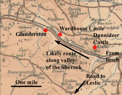 |
| The presence of two castles
and an earlier hillfort suggests a route ran along
the valley of the Shevock. Note how close this charter
is to the charter immediately below for Rathmuriel. |
This
was a grant of Bartholomew Fleming where he granted
"the church of St. Drostan of Inchemabani (i.e.
Insch) a toft and two acres of arable land adjoining
the toft in his ville of Ravengille between the great
road and the moor towards Gillandreston" along
with the common easement of this ville and common pasture
for some animals.
Interpretation
Weredors
is now called Wardhouse in Insch parish (RCAHMS NJ 5930
2888) and Gillandreston is Glanderston in Kennethmont
parish, about one mile to the west (Notes p.254). There
is no trace of Ravengille. From the wording we would
assume "the great road" ran along the valley
of the Shevock much as the main road does today.
There
is a strong possibility that the road was a main route
that ran from Inverurie past here to Huntly and beyond.
Some support to this is given by Davidson in his Inverurie
and the Earldom of Garioch (page 3) where he places
the nearby Dunnideer Castle on the NW boundary of the
Garioch where it would guard the natural routeway along
the valley of the Shevock - the castle at Inverurie
would guard the southern approaches to the area, along
with the important fording points of the Urie and the
Don there. Interestingly Dunnideer Castle is sited within
an earlier hillfort, presumably located here for the
same purpose.
There
was a settlement of Flemings in the area (including
Bartholomew) as shown by the nearby "Flinders"
placenames, which would have led to the development
of local routes.
The
Castles of Dunnideer and Wardhouse, in the Garioch,
Aberdeenshire, W Douglas Simpson, PSAS,
Volume 69 (1934-35), pp 460-71
Rev.
John Davidson, Inverurie and the Earldom of Garioch
Parish
of Kinnemonth - Rathmuriel
 |
| Parish boundaries
near Leslie. Sleepytown is just north of Christ's
Kirk. |
In
a charter of William of Brechin dating from 1245 there
is a reference to the church lands of Rathmuriel being
bounded by the highway from the ford of Ury towards
Leslyn (Leslie). They
were separated from the "other Rathmuryel"
that belonged to William.
Formerly
a separate parish, it was united with Kinnemonth in
the 1600's. The church was called Christ's Kirk and
there was an annual fair called Christ's Fair. This
was also known as Sleepy Fair as it was held at night.
The church and land had been gifted to Lindores Abbey.
Chartulary
of Lindores, page 60;
Epitaphs and Inscriptions, Vol.2, p.8, A.Jervise;
NMRS
record
POMS
3/100/3
Interpretation
On
the 6" map (Aberdeenshire sheet
XLIV) the church lands are shown as bounded by the
Dawache of Murrell
with
a parish boundary running along the road near the church,
making it very likely this is the highway referred to.
The only difficulty with the charter is the mention
of the Ury which is about 6 miles distant. The most
likely explanation is that it is the Shevock just to
the north that is being referred to, as it runs into
the Ury. Davidson in Inverurie and the Earldom of the
Garioch (page
8) suggests the road came from Dunnideer castle.
Drumoak
Dulmayok (REA,
pps.52 and 246)
On
page 52 of the Registrum Episcopatus Aberdonensis there
is a charter of 1331 in which the bishop gave William
Irvine the lands of Dulmayoch and Petbracher next to
the forest of Drum, along with rights of pasture, for
payment of a certain sum.
On
page 246 the boundaries of Dulmayok are given (Nota
limites de Dulmayok).
"In
the first the meir burne thro the merefurde the hirde
hillok (the shepherd's hillock - see DSL) the .......stane
the sledegat off ard'gyne the ball bush the modermyre
(source of a waterway through a myre - see DSL) the
h.......off petbrachare at the forest syde"
Interpretation
Dulmayok is in Drumoak parish about 9 miles wast of
Aberdeen and on the north side of the Dee. There is
an old church there and a farm called Dalmaik and the
meir burne may possibly be the stream forming the parish
boundary near the church. Unfortunately the other place
names are lost. Sledegat is interesting as it implies
a track on which sledges were used.
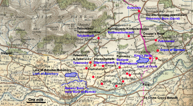
Banchory
Ternan and Drumoak
In
a charter of 1247 relating to a grant of lands in Banchory,
Drumoak and Peterculter parishes there is a reference
to a road running through a place called Starnamoneth,
north of Banchory, and two other roads. Another charter
of 1358 confirming an earlier charter of 1323 for much
the same area has other references and helps to identify
some ofthe locations. Also very useful is Gordon's map
of 1634 of land in this area (see link below). For convenience
we will treat the Peterculter grant separately from
the Banchory and Drumoak grant. This mentions a couple
of roads.
In
what follows we wll restrict comments to just those
parts of the charters that mention roads rather than
the complete charters as not all details are relevant.
The map below shows those places that can be identified
and allow us to see where the roads were to be found.
 |
| The
area covered by the charters and Gordon's map. Placenames
in italics appear on Gordon, those in black in Alexander's
charter, and those in blue in David II's charter.
Click for larger map. |
|
1247 Charter
Abstract from The Family of
Burnett of Leys with additions in brackets from
the original text of the charter.
KING ALEXANDER II grants to Robert, son of Alan
Walchope, for his homage and service, the land
of Tulimacboythne, from Blairmacogamgor towards
the land of Glascul, belonging to the Bishop of
St. Andrews, to the Loch of Banchory, and thence
to Tuberusky and Starnamanath, (entering and
exiting by the road of Starnamoneth - intrando
et exeundo per viam de Starnamoneth) and through
the mid forest to Burn (with the fishing thereof),
and on the other hand from Starnamanath to Pulnacoy,
and (so by a dry road - viam siccam) to
the burn of Perferyn, and northwards therefrom
(by a dry road - viam siccam) to Kilmaclerauche
and thence to the land of Gormeg, belonging to
Alan Durward; also the lands of Culter and Ardboik.........
(see Peterculter and Skene parishes below)
Original text: Collections for
a History of the Shires of Aberdeen and Banff,
Vol.2-5,
p, 298
See
also The
family of Burnett of Leys, (1901) Page 151.
This has the original text and a summary translation;
however, see note opposite on the viam siccam.
Tulimacboythne/Tullibole is identified
as Kilduthie on the Paradox
of Medieval Scotland website
.
|
Interpretation
Although
Starnamoneth is marked on Robert Gordon's map
(A
map of the district along the north side of the
River Dee near Crathes and Durres) it is hard
to say what route the road might have had. The
name is Gaelic for "moor road" or "moor
crossing".
Pulnacoy
is probably present day Coy and the Burn of Perferyn
is probably the Bo Burn/Black Burn. This fits
David's charter if we identify Pulnacoy with its
Badinse/Badindessy and the Badindaff of Gordon
(or its close vicinity) and also fits the estate
boundary for Coy shown on William Garden's map
of Kincardine. From the Bo Burn it would be
a mile to Kilmaclerauche (now Candyglirache).
The
estate boundary of Garden's map would be the first
dry road (viam siccam) with another dry road leading
to Candyglirache.
There
is some uncertainty about this however as the
original text in the Family of Burnett book has
unam sicam instead of viam siccam - this would
mean a ditch rather than road or path.
|
|
1358
Charter
Abstract from The Family of
Burnett of Leys
In 1358 KING DAVID II confirms a charter dated
at Berwick on Tweed, 28th March,1323 by which
King Robert granted to Alexander Burnard, for
his aid in making the Park of Drum, the land of
Kellienachclerach, from the Gonnochy burn to the
well of Tubirnanen and the old road leading to
the cross of Barricor, and downwards by the Sclaye
to the King's Well running into the Loch of Drum
to the east of the said Alexander's land, and
on the west of the King's forest to the old boundaries
of the land of Tolybothuill, and of Culenerly;
and the lands within the King's forest of Drum
outwith the Park thereof from the ford of Durris
along the Dee to the Banevy burn (Burn of Bennie)
and up the said burn to the Loch of Banchory (Loch
of Leys), together with the Loch and island therein,
and from the ford of the Loch to the well of Tuberusky
on the north, and thence to the cross of Starnamanach,
and thence to the old boundary of Badinse, and
thence to the north of Badindessy, and thence
to the Loch of Drum.......
Original text and above summary:
The
Family of Burnett of Leys, (1901), page
154
|
Interpretation
As noted the latter part of the 1358 charter offers
some support for the interpretation above.
The
first part of the charter with its old road leading
from the well of Tubirnanen to the cross of Barricor
can be interpreted in two ways depending on how
we read Gordon's map east of the Loch of Drum,
particularly if the line is of the road or the
Sclaye.
The
map shows a Crossbarricor near to the well of
Tubirnaven. Crossbarricor very much fits the present
Barrowsgate and Tubirnaven is probably one of
the wells shown on the 1:25,000 OS map (NO79
and NJ70) near Coldstream (Tobar is Gaelic for
a well or spring).
The
first interpretation would have the old road run
south from near Coldstream to Barrowsgate, the
boundary then continuing towards the Kings Well.
The immediate problem with this is that there
is no sign of the "Sclaye" at the present
day. There is a short length of stream on Robertson's
1822 map and a hint of a channel in the contour
lines of the 1:25,000 map that may have been the
Sclaye although it could not have continued beyond
Barricor which lies on a hill, whereas Gordon's
map suggests it does go beyond the hill.
The
other interpretation is that the old gate comes
more directly from the north and is in fact the
Couper's Road said to be very old and making directly
for the ford of Durris, which is mentioned in
David's charter. The reference to the cross of
Barricor could fit by assuming the cross was on
top of the hill where Barrowsgate is now and be
visible from the road.
On the south side of the Dee the Couper's road
continued as the Cryne Cross Mounth.
G
M Fraser in The Old Deeside Road, p.99 has some
details of this road. It was clearly very old
as it formed the old county boundary (see Robertson's
map of 1822). W Douglas Simpson also mentions
work done by a William Kelly on the area in the
Early
Castles of Mar (PSAS, 63 (1928-29), page 133).
This has Tubirnaven by the Couper's Road which
would favour the second of the two interpretations
above. The DSL gives one meaning of "couper"
as a horse or cattle dealer indicating its use
as a drove road.
|
Peter
Culter and Skene Parishes
The
two charters for Drumoak and Banchory above continue
with references to grants of land in Peter Cultur and
Skene parishes.

|
| The lands described in the charter.
The streams are as shown on Thomson's map of 1826,
much longer than today due to drainage schemes. |
|
1247
Charter of Alexander II
Abstract from The
family of Burnett of Leys, (1901) Page 151,
also original text.
.....also
the lands of Cultur and Arboik, from Achmasoliche
(Camrisilick) to Setnabradiauch (Technabrodach),
and thence to the burn of Cardany, and along it
to the Wolves' dens towards the land of the Bishop
of Aberdeen.....
See also Collections for a History
of the Shires of Aberdeen and Banff, Vol.2-5,
page 298 for
original Latin text.
The names in brackets are as
given in the original Latin text.
|
Interpretation
This
is included here for completeness as it is the
continuation of the 1247 charter above. As it
does not contain any references to roads we need
not be concerned with identifying the placenames
although there is an Ardbeck Hill just north of
Peterculter itself.
|
|
1358
Charter of David II
Abstract from The
family of Burnett of Leys, (1901) Page 154,
also original text.
....also, in compensation for the loss of the
forestership of the Forest of Drum, the six merk
lands of the two Cardenys in the shire of Aberdeen,
from the Thornbush east of Wester Cardeny down
to the Stainlethe, and thence to the high road
of Cardeny, and down the burn to the water of
Locher, and up to Badyennach, and thence to the
bog of Cask, and thence to the burn of Frifady,
and thence to the road through the midst of Skene
of Wester Cardeny, and back by a cart road to
the said Thorn bush: to be held of the
King by the said Alexander, paying a chalder of
oatmeal yearly.
The above renders the two fords of the original
text as roads. While this might not matter too
much as fords imply roads, a more literal translation
is given here, viz: "the six mark lands below
our lands of the two Cardenys in the shire of
Aberdeen, by these bounds and divisions, namely
the vill of Westercardeny beginning at the thorn
bush on the east side of the said vill and so
descending to the Stainlethe and from there to
the wide ford of the said vill of Cardeny and
so descending by the burn to the water of Lochar
and so ascending
as far as Badyennach and from there to the bog
of Gask and from there to the burn of ffrifady
and thence to the ford between the half davochs
of Skene and of Westercardenny and so returning
by a cart road to the foresaid thorn bush."
..... sex marcatas terre infra terras nostras
de duabus Cardeinys in vicecomitatu de Abirdene
per has metas et diuisas videlicet villam de Westercardeny
incipiendo
apud Dumum Spinarum ex orientali parte dicte ville
sic descendendo vsque le Stainlethe et ab hinc
vsque ad latum vadum dicte ville de Cardeny et
sic descendendo per riuulum vsque ad aquam de
Locher et sic ascendendo vsque Badyennach et ab
hinc vsque le lecche de Gask et ab hinc vsque
riuulum de ffrifady et ab hinc vsque ad vadum
inter dimidiam dauatam de Skene de Westercardeny
et sic redeundo per vnam viam plaustrorum vsque
ad dumum spinarum predictum
|
Interpretation
Using
the literal translation, and noting that the streams
had longer courses prior to drainage schemes (as
shown on Thomson's map of 1826 and the above map),
a possible fit can be found by assuming the Stainlethe
is one of the two streams just south of Westercardeny.
We can follow this down to "the wide ford"
(which could imply a track running up to Westercardeny)
and then down to the water of Lochar.
Following
this upstream (it forms the boundary between Peter
Culter and Skene parishes here) towards its source
in the Loch of Skene, we come to a place which
today is called Torshinach and which could be
the Badyennach of the charter with the "bog
of Gask" nearby. The ffrifady would then
be the burn entering the Loch of Skene on its
eastern side and which rose quite far to the east.
At
one point there must have been a ford over this
burn, now called Mackie's Steps. Rather than there
being two separate roads as mentioned in the summary
translation it is more likely that the ford was
used by the cart road on a north south alignment.
It is not clear if it was linked to the other
road above though they both went through the lands
of Westercardeny.
|
New
Machar
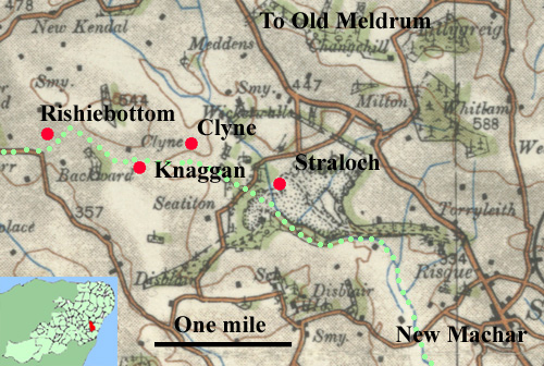 |
| The
"road to the mountains" would presumably
have come from Aberdeen and headed north-westwards.
The green dots show part of a parish boundary. |
Register
of Arbroath Charter 227, Vol. 1, Page 161/162
The
first part of this charter which dates from 1236 is
concerned with a perambulation of the bounds of part
of Tarves -no roads are mentioned.
The
next day a meeting was held to discuss the bounds between
abbey lands and Strathlochath. The charter says:
"on the morrow of the same day recognition was made
by a party of good men of the right divisions between
the lands of the Abbot and convent of Abirbrothoc and
the lands of Strathlochath viz. by leyn / conueggy and
by the road to the mountains as far as the waste called
Rassalath, and as Rassalath descends to the rivulet
of Orky."
in crastino eiusdem diei recognite
fuerunt per iuramentum proborum virorum recte diuise
inter terram Abbatis et conuentus de Abirbrothoc et
terram de Strathlochath / viz per leyn / conueggy et
per stratam montis usque ad wascellum qui dicitur Rassalath
/ et sicut Rassalath descendit in riuulum de orky.
Interpretation
Although there is a place called Rosullah about 4 miles
west of Tarves, a stronger possibility is that Strathlochath
is Straloch, two miles north-west of New Machar. Within
a mile of two to the west of Straloch there is a Clyne
and a Knaggan. It would seem far too far to assume the
Rassalath was that near Tarves (more than 7 miles distant),
however older maps show a Rashiebottom, one mile west
of Knaggan (there is another place of this name one
kilometre to the south but the more northerly is preferable).
The meaning of Rassalath and Rashiebottom is much the
same if it is rushes that are being talked about and
lath is leth meaning a marshy place. The name of the
Orky has disappeared.
Apart from the similarities of the place names, what
gives some credence to this is that all the places are
on or near the parish boundary and the meeting took
place the day after the one in Tarves, thus allowing
time for travel. As for the road to the mountains, the
location would fit a road from Aberdeen albeit a little
to the west of the present road. The term stratam is
difficult as it can imply a paved road, often Roman,
though none is known in the area. It may however just
mean a highway in this document.
Tarves/Udny
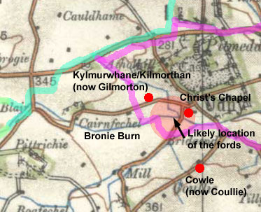 |
| Places
mentioned in the charters. The green line is the
parish boundary and the purple line is from Alexander
Gibb's 1858 map showing an estate boundary that
may be that of the first document. |
A
perambulation between the lands of Tarves and Udny dating
from 1417 refers to two fords near Udny, viz. the ford
of Christ's Chapel and the black ford. Another
charter of 1469 also mentions the black ford.
The documents, particularly the first, are very difficult
to interpret. However, from the wording of the first
document it is clear enough that both fords were in
the vicinity of Udny (where Christ's Chapel was located)
and Gilmorton. The boundary starts on the east side
of the vill of Cowle and descends by a stream past a
rumbling well to the Brony and follows this upstream
in a westerly direction to the ford of Christ's Chapel.
The black ford seems to have been over a smaller stream
nearby. Gilmorton is mentioned after the black ford.
Registrum
de Aberbrothoc, Vol.
2, Page 51, charter 53, 1417
Registrum
de Aberbrothoc, Vol. 2, Page 161, charter 182, 1469
Ellon
A
document of 1551 details the results of the examination
by witnesses of a dispute about the marches between Nethir
Ardlethen and the Ald mill of Essilmonth which are a couple
of miles west of Ellon. In this it mentions "the
breaking of the gate ascending fra Aquharnies furd halden
the hie gate that passit that tym to the Chapel of Dumbreck
quhil it cum to Clottinpanis Stane...."
Illustrations
of the topography and antiquities of the shires of Aberdeen
and Banff, v.3, 1847, page 20-21
Interpretation
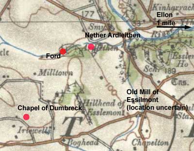 The
wording of this is a little obscure as can be seen from
the variation in meanings given in the Dictionary
of the Scots Language. This leads to an ambiguity,
namely, whether a track led up to and joined the "hie
gate" that then carried on past the chapel or whether
the track using the ford was itself the "hie gate." The
wording of this is a little obscure as can be seen from
the variation in meanings given in the Dictionary
of the Scots Language. This leads to an ambiguity,
namely, whether a track led up to and joined the "hie
gate" that then carried on past the chapel or whether
the track using the ford was itself the "hie gate."
The various locations can be seen from the map. Clottinpanis
stone has disappeared but was said to have been on the
lands of Dumbreck (Thanage of Formartyn, page 470).
The placename of Aquharnies has also disappeared but
is more likely to have been over the Yowlie Burn, perhaps
the ford shown on the 1st edition 6" map, rather
than the ford over the Ythan at Kinharrachie.
The
wording of the document could suggest the "hie
gate" was a local route from Ellon towards the
Udny/Pitmedden area. If so, it could be linked with
the "kirkgate" near Ellon.
Ellon
In
an agreement on the marches between Fortrie and Essilmont
(1537) there is a mention of the Kirkgate in the parish
of Ellon, viz. "Begining at the Corne burn in the
Kirkgate at an ald carn of stanes new reformit and
frathencefurth south-eist direct to a gret gray stane
in the bra And frathin est to the ald dyke of the Hill
fauld And frathin to the northeist part of the Woll
law haldin under the bra as it is carnit to the well
of the Woll law And frathine to the meiting of the twa
myres at the hed of the burn of the Fortree And frathine
as it is carnit ascendand to the carn of the Turf hill
at the heid of the Lards bra And fra that to a carn
callit the Leurok carn upon the north side of the roof
of the Bog hill And fra the said carn to the Corne burn
descendand the ald passage of the said burn to the water
of Ithane "
Illustrations
of the topography and antiquities of the shires of Aberdeen
and Banff, v.3, 1847, page 16-17
Interpretation
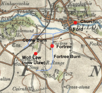 The
only placenames surviving are Fortrie itself (the present
day farm of Fortree is less than a mile to the south-west
of Ellon) and Woll (present-day Ulaw near Fortree). The
only placenames surviving are Fortrie itself (the present
day farm of Fortree is less than a mile to the south-west
of Ellon) and Woll (present-day Ulaw near Fortree).
One
other clue is that on older maps, e.g Thomson and Robertson,
the former courses of streams in this area are shown
and that it is likely that the Fortree burn is the stream
to the east and the Corne burn the one to the west,
with both running into the Ythan.
Given
that the document starts at the Carne burn it is very
likely that the Kirkgate ran just south of the Ythan,
probably crossing the Corne burn to reach the then ford
near the present day bridge of Ellon. The kirk itself
was nearby on the north side of the Ythan.
Ellon
Bischop Brynnes (mid-1400's) (REA, p.247)
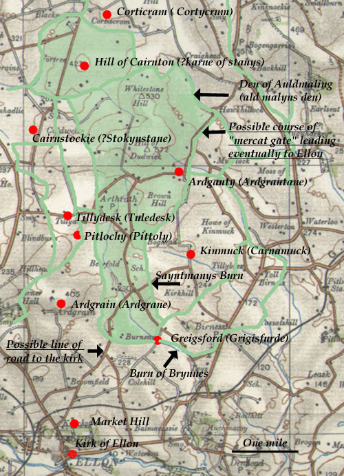 Memorandum
that the ar the meris of Bischop Brynnes • In the
first begynnand at Girgisfurde ascendand west a grete
lech (small stream draining marshy ground - see DSL)
til it cum oure a rode to the brede of an akyr the quhilk
rod strekis fra Bischop Brynnes the nerrast gate our
the moss to the kyrk of Ellon and fra thine merkand
northwest our a moss to the nerrast teleland of Ardgrane
and fra thine a perty northest to the estmast welespring
betuix the landis of Bischop Brynnes and Ardgrane the
moss and the mersk to Bischop Brynnes and the teleland
to Ardgrane and fra that wele ascendand vp an ald fald
dyk to the hill and fra thine descendand down the hill
syde til a moss and swa throw that moss on the west
half of the muryinch of Bischop Brynnes til it cum to
the burne of Tuledesk quhar it and the lechis of Pittolly
metis togidder and swa ascendand that lech til it cum
til a lech laid on ilke syde with mannys handis and
swa ascendand a mikil lech to the hede of it on west
half the stokynstane and fra thine north west to the
Blakloch and fra thine up a lech to the teleland and
a furschot lynth and sua ascendand a perty northest
til a karne of stanys in the hicht of that hill nerrast
and fra thine descendand to the Hartuellys and swa dovn
the strynde (stream usually issuing from a spring -
see "strinde" - DSL) of that wellis til it
enter in a burne and swa ascendand that burne til it
worth (becomes) a lech and swa ascendand that lech til
it cum to the Karlynden and swa throw the said den (narrow
valley) descendand a stripe til it cum to the burn of
Cortycrum and swa ascendand that burne til it cum to
a lech ner the hede of that burn and sua ascendand that
lech and on the esthalf of a slak (prob. a marshy low
area) and vp to the hede of ald malynis den and swa
descendand dovn the den til it cum to the furde and
the mercat gate and swa ascendand the merkat gate and
throw the furde of Ardgrantane til it cum til a litil
slak and standand stanys northwest a perty fra Carnamuk
and swa descendand throw the mur to the slak of Tornawys
and swa doun throw the moss and on the westhalf of the
jnsnochley (insnochley) of carnamuk And swa doun throw
the jnsnochmoss to the hede of the Sayntmanynis burn
and swa dovn the burne til it enter in the burne of
Brynnes and swa till it enter in Grigisfurde quhar we
begouth first... Memorandum
that the ar the meris of Bischop Brynnes • In the
first begynnand at Girgisfurde ascendand west a grete
lech (small stream draining marshy ground - see DSL)
til it cum oure a rode to the brede of an akyr the quhilk
rod strekis fra Bischop Brynnes the nerrast gate our
the moss to the kyrk of Ellon and fra thine merkand
northwest our a moss to the nerrast teleland of Ardgrane
and fra thine a perty northest to the estmast welespring
betuix the landis of Bischop Brynnes and Ardgrane the
moss and the mersk to Bischop Brynnes and the teleland
to Ardgrane and fra that wele ascendand vp an ald fald
dyk to the hill and fra thine descendand down the hill
syde til a moss and swa throw that moss on the west
half of the muryinch of Bischop Brynnes til it cum to
the burne of Tuledesk quhar it and the lechis of Pittolly
metis togidder and swa ascendand that lech til it cum
til a lech laid on ilke syde with mannys handis and
swa ascendand a mikil lech to the hede of it on west
half the stokynstane and fra thine north west to the
Blakloch and fra thine up a lech to the teleland and
a furschot lynth and sua ascendand a perty northest
til a karne of stanys in the hicht of that hill nerrast
and fra thine descendand to the Hartuellys and swa dovn
the strynde (stream usually issuing from a spring -
see "strinde" - DSL) of that wellis til it
enter in a burne and swa ascendand that burne til it
worth (becomes) a lech and swa ascendand that lech til
it cum to the Karlynden and swa throw the said den (narrow
valley) descendand a stripe til it cum to the burn of
Cortycrum and swa ascendand that burne til it cum to
a lech ner the hede of that burn and sua ascendand that
lech and on the esthalf of a slak (prob. a marshy low
area) and vp to the hede of ald malynis den and swa
descendand dovn the den til it cum to the furde and
the mercat gate and swa ascendand the merkat gate and
throw the furde of Ardgrantane til it cum til a litil
slak and standand stanys northwest a perty fra Carnamuk
and swa descendand throw the mur to the slak of Tornawys
and swa doun throw the moss and on the westhalf of the
jnsnochley (insnochley) of carnamuk And swa doun throw
the jnsnochmoss to the hede of the Sayntmanynis burn
and swa dovn the burne til it enter in the burne of
Brynnes and swa till it enter in Grigisfurde quhar we
begouth first...
Interpretation
Normally it would be difficult to identify these
boundaries but George Forrest Brown in his book On
Some Antiquities in the Neighbourhood of Duncht House
(1921) says that Bishop's Brynnes is now Dudwick (parish
of Ellon). The boundaries of Dudwick are shown on a
map
of Aberdeenshire (NLS website) by Alexander Gibb
(1858) delineating various estates in the county. When
the charter is compared with the map it becomes evident
that they are dealing with the same boundaries (most
of which are water-courses) with the exception of Fortree
immediately to the north which should be included in
Bishop's Brynnes.
This
allows us to fix the references to roads and fords more
closely. The road that goes to the kirk of Ellon (this
was on the present site of the church) must have been
between Greigsford and Ardgrain, very close in fact
to the road shown on the map which if not the same can
be taken as indicative of its line. The other road,
the mercat gate, must be close to the Den of Auldmaling
(which had a ford where the present road crosses it)
and Ardganty and may in fact be shown by the boundary
and present road between these places as this is not
a watercourse; at Ardganty another burn is crossed which
may be the "furde of Ardgrantane." The reference
to market suggests a local route to Ellon perhaps through
Griegsford or by the road to the kirk in that locality.
Bourtie
Two
charters, one by William of Lamberton and a confirmation
charter by his son Alexander, relate to a gift to St
Andrews Priory of the church of Bowird and of 12 acres
"next to the church lands towards the west, and
on the other hand by the road towards the north..."
.....xij acras terre iacentes iuxta terram
ecclesie uersus occidentem ex altera parte uie versus
aquilonem ...
St
Andrews Liber page 267
POMS
Interpretation
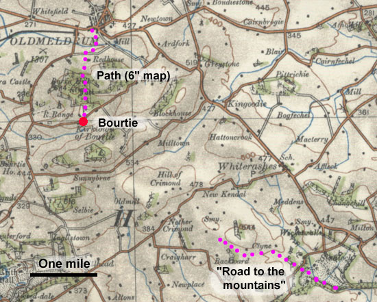 The
village is situated between Inverurie and Old Meldrum.
One would suspect the "road to the north"
would have led to Old Meldrum and in fact the 6"
map shows a path leading past the Hill of Barra to the
town but there is insufficient information to confirm
this. An attractive possibility is that it was the continuation
of the "road to the mountains" in New
Machar parish which we last hear of about 3 miles
to the south-east but again this would need confirmation. The
village is situated between Inverurie and Old Meldrum.
One would suspect the "road to the north"
would have led to Old Meldrum and in fact the 6"
map shows a path leading past the Hill of Barra to the
town but there is insufficient information to confirm
this. An attractive possibility is that it was the continuation
of the "road to the mountains" in New
Machar parish which we last hear of about 3 miles
to the south-east but again this would need confirmation.
The
Mounth Passes and Ferries
on the River Dee
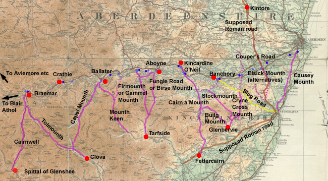 |
| Map
of the Mounth passes based on Fraser's map (see
paper below) and of the ferries listed by Balfour.
In addition to these ferries (dark blue) there were
also fords (light blue), some of the main ones being
shown above. These would have connected with the
Mounth passes and would have given access to routes
leading to the north. For further details of fords
see The Old Deeside Road, G M Fraser. Click map
for larger image. |
In
the View of the Diocese of Aberdeen contained in the
Collections for a History of the Shires of Aberdeen
and Banff, there are details of various ferries over
the River Dee and of eleven passes over the Mounth,
the mountainous range that stretched from upper Deeside
to the coast south of Aberdeen. The notes had been written
by Sir James Balfour sometime before 1657, the date
of his death, and it is very likely that the ferries
and passes over the Mounth were in existence well before
that time. Some were of sufficient importance to become
surfaced roads, still in use today. Others had fallen
into disuse by the late 1800's and are now used only
for recreational purposes.
One
major use of the passes, even at an early date, was
for droving. On the north side of the Dee various routes
would converge towards a crossing point, continue as
the one route over the mountainous terrain and then
split into different tracks leading to the various fairs
and markets south of the Mounth and then onwards to
Crieff and at a later date, the trysts at Falkirk. The
passes were also used by seasonal workers travelling
south in search of work.
The
easternmost pass is the Causey Mounth. It was the main
route from the south to Aberdeen until replaced by the
turnpike and got its name from stretches of causeway
laid across boggy ground.
The
route taken by the Elsick Mounth is uncertain with Fraser
(see below) saying it followed the line of a possible
Roman road between the camps at Raedykes and Normandykes
using a ford on this supposed road at Tilbouries near
Peter Culter, and others having it run a mile or two
to the west and probably crossing the Dee at Dalmaik.
In either case, Balfour gives the destination as Drum
(Castle). Balfour doesn't mention the Slug Road, although
it must have served as a link between the Banchory/Durris
area and Stonehaven. The route shown on the map is that
of the pre-turnpike, the turnpike line being that of
the modern road.
Three
passes converged from the north on the area near Glenbervie
close to where the Paldy Fair was held. These were the
Cryne Cross Mounth on the east, the Stock Mounth in
the centre, and the Builg Mounth to the west. The Cryne
Cross Mounth was used by Edward I, and Fraser mentions
about 30 yards of paving on the Hill of Mossmaud and
a local tradition that this paving could be Roman. It
crossed the Slug Road with branches reaching the Dee
at the Mills of Drum and Durris. At Durris it continued
on the north side of the Dee as the Couper's Road, couper
being a name for a cattle or horse dealer. The Couper's
Road is on the county boundary indicating the road must
have existed in the early middle ages. The Stock Mounth
went to Strachan on the Water of Feugh from where Banchory
or the Cairn a' Mounth Road could be reached and the
Builg Mounth went more directly to the Cairn a'Mounth
Road.
The
Cairn a'Mounth Road, well-known for being improved as
a Hanoverian military road, ran from Fettercairn up
to the Dee at Kincardine O'Neil and on into the north
country. There was an inn at Whitestone mentioned in
1511 - "the quhitstane at thee mvreaile hous"
(see Birse above) and a bridge
(still standing) which was built over the Water of Dye
about 1680.
The
next three of Balfour's passes ran from Dee side between
Ballater and Aboyne south to Glen Esk and from there
to Edzell and Brechin. Looking north from Glenesk the
Birse Mounth and the Gammel Mounth were probably one
and the same path from Tarfside up to the county boundary
where it divided, the easternmost path (Birse Mounth,
also known as the Fungle) running up to Aboyne and the
westernmost path (Gammel Mounth, also known as the Fir
Mounth) running up to Glentannar with branches coming
from Aboyne and near Dinnet to the west of Aboyne. Still
in Glen Esk, 3 miles west of Tarfside at the end of
the public road, the Mounth Keen track ran north to
Canakyle, now Deecastle, with a branch to Ballater.
The
tenth of Balfour's passes is Capel Mounth which starts
in Glen Clova then heads north past Loch Muick to the
Dee just south of Ballater. At the north end of the
loch it passed a spittal
(Canmore record) said to have been founded by the Bishop
of Aberdeen, hence the "chapel". This pass
is shown on the Gough
Map of c.1360 as Month Capelle as is the Causey
or Cowie Mounth, here called Monthe colli. In both cases
the map says "here is a passage".
The
final pass is Carnavalage Mounth, now called the Cairnwell
Mount but as the Carnavalage shows would originally
have been Carn 'a bhealaich, cairn of the pass (see
Fraser below). There was a spittal at Glenshee and the
road was improved as a military road in Hanoverian times.
This
excerpt below is Balfour's list of ferries and passes
from View of the County of Aberdeen contained in the
Collections
for a History of the Shires of Aberdeen and Banff, p.77.
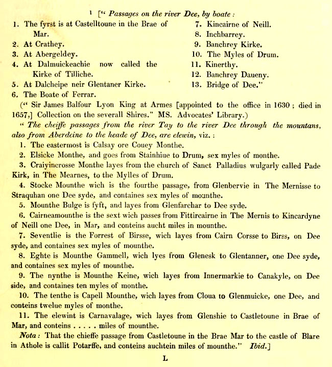
Reproduced from National Library of Scotland digital
copy on Internet Archive under a Creative
Commons Licence, Attribution-Noncommercial-Share Alike
2.5 UK: Scotland
Additional
References
The
Mounth Passes over the Grampians, G M Fraser, Scottish
Geographical Magazine, Volume 36, 1920, pages 116 -
122 and continued on pages 169 - 180
http://en.wikipedia.org/wiki/Causey_Mounth
http://www.mearns.org.uk/stonehaven/nhwalk5.htm
Megalithic
Portal, Causey Mounth - Ancient Trackway in Scotland
in Aberdeenshire, C Michael Hogan
Heritage
Paths - see Grampian and Angus and Tayside for details
of paths over the Mounth
Megalithic
Portal, Elsick Mounth - Ancient Trackway in Scotland
in Aberdeenshire, C Michael Hogan
Elsick
Mounth leaflet, Friends of Durris Forests
Grampian
Ways, Robert Smith, John Donald, Edinburgh 2002
The Mounth Passes: A Heritage Guide to the Old Ways
Through the Grampian Mountains. Nate Pedersen and Neil
Ramsay, with photographs by Graham Marr. This is an
eBook and is a compilation of a series of articles the
authors wrote for Leopard magazine in Scotland between
2011 and 2012. Published: January 2014. The British
version is available here.
Top
|