|
Brechin
Charters
Overview
 |
| Overview
map - click for larger image
|
The evidence looked at so far for
this section are charters in the Registrum Episcopatus
Brechinensis,
Edward the First's Itinerary in his invasions
of Scotland and the Mounth passes that led into Aberdeenshire
and the north-east. Charters for Arbroath abbey are
looked at below.
Both
Edward's Itinerary and the Mounth passes give a good
idea of what main routes there must have been although
inevitably we cannot be quite sure what route was taken
in each stage of the Itinerary. This could be quite
different from what is suggested by modern roads - for
example, the older maps
show that there was an old route between Kincardine
castle and Glenbervie when the present day road did
not exist. The exact routes of the Mounth passes are
much more certain and were undoubtedly in use at this
time - the Gough map, for example, shows two of them.
The
charters for Brechin cathedral deal mostly with local
roads although a mercat gate to Montrose is mentioned
in 1566 and the bridge, which dates from the early 1200's,
must entail routes to Forfar (and so Perth) and Dundee
and possibly Old Montrose which could have served as
a port for Brechin for a period. There is an intriguing
"Kindrokat" (bridgend) a couple of miles west
of Brechin but no tradition of this bridge and its purpose
have survived.
Also
long-distance is a route by Edzell, where there was
an important castle, to Glenesk, from where three of
the Mounth passes could be accessed. One charter mentions
the road to Kincardine (Mearns) which ties in with one
of Edward's stages though it is not clear if the charter
route went like Edward's up towards Edzell and crossed
the river to Dalladies, or if it headed to the North
Water bridge where there may have been an early crossing
point.
Of
the local roads they are mostly to local farms or to
the common land and stretch at most, 3 or 4 miles. It
is not clear if they continued beyond their stated destination
or if such links were a much later development, although
one would suspect Brechin was an important market from
early on.
There
are numerous references to streets and lanes in the
town.
Some charters for Dundee are included
in the Register. Apart from names of streets in the
town there is an Argylesgate with a road to Invergowrie
and presumably Perth and perhaps further west.
The
charters referred to below can be found in the Registrum
Episcopatus Brechinensis (2 vols).
Details of charters pre-1314 can be found on the PoMS
website here.
Amanda Beam, John Bradley, Dauvit Broun,
John Reuben Davies, Matthew Hammond, Michele Pasin (with
others), The People of Medieval Scotland, 1093�1314
(Glasgow and London, 2012) www.poms.ac.uk.
Brechin
- Maisondieu
Fundacio de Messyndew
Registrum
Episcopatus Brechinensis,
Vol. I, Charter 3, page 4 (1267)
This
charter records a gift of land for a chapel the donor
had established near Brechin and various provisions
for its upkeep. A couple of roads are mentioned as follows:
....the whole land in which the
chapel is situated by its right bounds, viz. beginning
at the land of Moisy the tailor (see here)
as far as a certain syke which is called Gamech and
from that syke as far as a certain causeway leading
to the petary of Brechin and so towards the north from
the western side of the ville of Balherquhynn by the
road which leads to the moor and from there eastwards
as far as the land called Baldouethagy with half of
that land, the other half of which is held by Walterus
Coquus, and then towards the south as far as the foresaid
sike of Gamech and then the stream running towards the
east to the high road which leads from Brechin towards
Kincardine and descending by the same road to the town
of Brechin.
......totam terram in
qua capella sita est per rectas diuisas suas viz. incipiendo
a terra Moisy scissoris usque ad quandam siketam que
vocatur Gamech et ab illa siketa versus occidentem usque
ad quamdam calceam per quam itur ad Petariam de Brechine
et sic versus aquilonem ex occidentali parte ville de
Balherquhynn per viam que ducit in moram et inde versus
orientem usque ad terram que vocatur Baldouegathy cum
medietate illius terre cuius aliam medietatem Walterus
Coquus tenet et inde versus austrum usque ad predictam
siketam Gamech et inde usque ad riuulum currentem versus
orientem ad altam viam que ducit de Brechine versus
Kincardine descendendo per eandem viam usque ad villam
de Brechine.
Interpretation
 It is hard to be specific about the roads mentioned
at the start of this extract, other than that they would
be to the north-west of the town near to Maisondieu
and Cookston (which from the wording is likely to be
near Baldouethagy). Other charters suggest the muir
was north and north-west of Maisondieu. The track on
the map that leads from the town to Maisondieu must
date from early on though it is not clear if it is one
of those mentioned in the charter.
It is hard to be specific about the roads mentioned
at the start of this extract, other than that they would
be to the north-west of the town near to Maisondieu
and Cookston (which from the wording is likely to be
near Baldouethagy). Other charters suggest the muir
was north and north-west of Maisondieu. The track on
the map that leads from the town to Maisondieu must
date from early on though it is not clear if it is one
of those mentioned in the charter.
The high road leading to Kincardine
is the one leading directly NNE of the town but it is
not certain what its route was in detail. One possibility
is that it went by North Water Bridge (Canmore
entry). Although this only dates from the early
1500's, it is likely enough that it was a well-used
route for sometime before that though it is hard to
say if it was in use at the time of the charter.
Another possibility is the route
taken by Edward I in 1303 who travelled by Stracathro
and Dalladies to Kincardine then onwards to Glenbervie,
Stonehaven and Aberdeen. There was a "King's Ford"
(referring to David I) at Stracathro which Edward must
have used as Dalladies is close by on the other side
of the river. Garden's Kincardineshire map (1774 - see
NLS
maps) shows the route from the ford to Kincardine
by minor roads, and interestingly enough by a track
from Mill of Kincardine on to Auchenblae and then minor
roads to Glenbervie. The current road from Fettercairn
(B966) did not exist at the time but there is a good
chance that the old track dates from Edward's time.
Brechin
- Cookston
Kuykestoune
Registrum Episcopatus Brechinensis,
Vol. I, Charter 49, Page 84
(1435/6)
This charter details the services
tenants of Cookston were required to carry out. A road
called The Lonynge is mentioned, as follows:
...........and in return for this service, the bishop
is bound to give them a road called Lonynge by which
they are able to go to the great moor and liberty to
collect heather in his moor of Fernwell for their use.
..........Et pro
isto seruicio tenetur episcopus dare eis unam viam que
dicitur Lonynge per quam possent ire ad magnam moram
ac licenciam capiendi bruarium in mora sua de Fernwell
ad usum ipsorum
Interpretation
 Ainslie's
map of 1794 shows a Cockstone Loan running for a few
hundred metres ENE from Cookston. Rather than the Lonynge
being to the south of Brechin near Farnell Moor it could
be that the charter extract refers to the "Cockstone
Loan" near Cookston and liberty to collect
heather on Farnell Moor which is about three miles south
of Brechin. If so, there would have been a track from
Brechin to Farnell. Ainslie's
map of 1794 shows a Cockstone Loan running for a few
hundred metres ENE from Cookston. Rather than the Lonynge
being to the south of Brechin near Farnell Moor it could
be that the charter extract refers to the "Cockstone
Loan" near Cookston and liberty to collect
heather on Farnell Moor which is about three miles south
of Brechin. If so, there would have been a track from
Brechin to Farnell.
Brechin
Road to Auchnacarret
Registrum Episcopatus Brechinensis,
Vol.
2, CCLXXXII, p. 325 (1583)
In this charter there is a reference to the common way
from Brechin to the villa of Auchnacarret - communem
viam qua itur a Brechin ad villam de Auchnacarret.
Although the place name has disappeared the charter
context suggests that it was to the north west of Brechin,
near to Maisondieu. However, there is not enough information
to identify the road.
Brechin
Road to Unthank
and Drumgrane
Registrum
Episcopatus Brechinensis
 Two charters mention a road leading to Unthank and Drumgrane,
viz.
Two charters mention a road leading to Unthank and Drumgrane,
viz.
Vol. 2,
CCLXXX, 321 (1578) ...the common
road which goes from the city of Brechin to the villa
of Unthank
communem viam qua itur a Ciuitate Brechinensi
ad villam de Vnthank
Vol. I, Charter 89, page
184 (1458)....the common street of Brechin leading
towards Drumgrane
.....communis vici ville de Brechine
extendens versus Drumgrane
Ainslie's map of
1794 shows Drumgrane about a mile out of town on the
main road north and opposite Onthank.
Menmore
Declaration on the bounds
and divisions of the lands of Menmor between the Bishop
of Brechin and Johannem de Cullace
Registrum Episcopatus Brechinensis,
Vol. I, Charter 75, page 147 (1450)
In this document dealing with
a boundary dispute in Menmuir, 5 miles NW of Brechin,
there is mention of a Threpehalchfurde over the Cruik
Water and a Waynfurd, which can not be identified -
the name implies it was used by waggons. Threpehalchfurde
is mentioned thus:
....Beginning from the east above
the said Water of Cruok at the place called Threpehalchfurde
on the Cruok or Alrynburne and extending above the said
stream towards the west as far as the place where the
Lochty enters in the Cruok or thereabouts, ever on the
south side of the Cruok beyond two small islands on
the north side...
�..Incipiendo ab oriente super dictam
aquam de Cruok a loco qui dicitur ye Threpehalchfurde
in Cruok vel ye Alrynburne extendendo super dictam aquam
versus occidentem usque ad locum ubi Lochty intrat in
Cruok vel eocirca semper ex australi latere dicte aque
de Cruok preter duas paruas insulas a parte boreali....
(See also Charter
80, page 163)
Interpretation
 A
Threep Ford is shown on the old 6" map and fits
the description as the confluence of the Lochty and
Cruok is upriver from the ford. The word "threep"
indicates a dispute of some kind. The ford is 100 metres
north of the present minor road. A
Threep Ford is shown on the old 6" map and fits
the description as the confluence of the Lochty and
Cruok is upriver from the ford. The word "threep"
indicates a dispute of some kind. The ford is 100 metres
north of the present minor road.
Brechin
Roads to Petpollux and Kyndrokat
Registrum
Episcopatus Brechinensis
Five charters refer to roads in
describing the location of properties in Brechin, as
follows:
Vol. I, Charter 92, p. 194 (1471-2) .....on the
one hand the king's highway on the north side which
leads to Petpullox and the Petmyr and on the other the
common road on the south side which leads to Kyndrochat...
viam regiam que ducit apud Petpullox et le Petmyr ex
parte boreali ex parte una et communem vicum [viam?]
que ducit apud Kyndrochat ex parte australi ex parte
altera
Vol. I, Charter 107, p. 214 (1497-8) the road on
the north which leads to Petpollox and the road which
leads to Kindrokat on the south....
viam que ducit ad Petpullox ad boream et viam que ducit
ad Kindrokat ad austrum
Vol. I, Charter 108, p. 215 (1497-8) the road
called the Kirkgait on the south and the road which
leads to Petullox on the north
viam dictam le Kirkgait ad austrum et viam que ducit
ad Petpullox ad boream
Vol. I, Charter 111, p. 220 (1505) on the north
the common king's highway which leads to Petpullox and
the road to the church on the south
communem viam regiam que ducit ad Petpullox ad boream
et viam ecclesie ad austrum
Vol. I, Charter 112, page 222 (1505) on
the north our king's street which leads towards Petpullox
and on the south side the road called the Kirkgate
vicum nostrum regium qui ducit versus Petpullox ex boreali,
et viam vocatam le Kirkgate ex australi partibus
See also
Vol. 2, CIX, p.171 (1515-6) ....viam quae ducit
ad Petpodlox
Interpretation
 |
| This map shows roads to Petpullox
and Kindrokat as well as Dubtoun, Corsden (Careston);
Haugh of Brechin, the Den and the Mill Den (see
below) |
These are likely to be identical
to or on the same line as the present day roads leading
to Barrelwell and to Forfar. Kindrokat is Gaelic for
"bridgend" but nothing is known about this
presumably very early bridge.
Brechin
Roads to Dubtoun, Corsden, the Haugh of Brechin, the
Den and the Mill Den
Registrum Episcopatus Brechinensis
Roads to the above places are
mentioned as follows (see above map for locations):
Vol. I,
Charter 114, page 228 (1552-3)
•
The road which leads to Dubtoun on the north
and the road that goes to the Haugh of Brechin
on the south
viam que ducit ad Dubtoun ad boream et
viam que tendit ad ly Hauch de Brechin ad austrum
•
on the north, the common king's highway (leading) to
the east and the stream descending by the hollow vulgarly
called the den to the west....
ad boream communem viam regiam ad orientem
et riuulum descendentem per antrum siue ly den vulgariter
nuncupatum ad occidentem
•
the lane to the north which
leads and goes to Doubtoun and the lane on the
south extending to Corsden..
venellam que ducit et tendit ad Doubtoun
ad boream et venellam extendentem ad ly Corsden ad austrum
Vol. 2, CXVI,
p.181 (1528) the road
which leads to Dubtoun on the north and the road
which leads to the haugh of Brechin on the south
viam quae ducit ad Dubtoun ad boream
et viam quae tendit ad lie Hawich de Brechine ad austrum
Vol. 2, CXXIV,189
(1537) common lane which
leads to Dubtoun; common road which leads to
Dubtoun
communem venellam que ducit ad Doubtoun;
communem viam que ducit ad Doubtoun
Vol. 2,
CLXVII, p. 234 (1605) road
leading to the Den
viam tendentem ad lie Den
Vol. 2, CCLV, p.294 (1611)...the
aforesaid road leading to the Myln Dane (Mill Dean)
viam predictam que ducit ad lie Myln
Dane
Interpretation
The road to Dubtoun is very likely to be the same as
the one to Petpullox. As the road to Corsden (entry
3 above) is differentiated from the Dubtoun road, it
is probably the same as the Kindrockat road. The Haugh
of Brechin lay south-west of the town but it is not
clear if the road is the Kindrockat road or another
road. The Den can be clearly seen on John
Wood's map (1823) as a valley just to the east of
the town. It was known as the Mill Dean nearer to the
main river.
Brechin
Road to Fendowrie
Registrum Episcopatus Brechinensis, Vol.
2, CCXLIV, p. 286 (1591)
This charter reads: ....commonly
called Monboy lying on the south side of our aforesaid
common moor having on the eastern side the lands of
Fendowrie, commonly called the Quhite Park dyke from
the southern part of the moor of Fendowrie and Balnabreich
as far as the lands of Quhitesyde looking towards (?)
the hereditary portioners (feuars - see here)
of Petforky and from thence northwards by the embedded
stones commonly called the merche stanis to the common
road in the southern part of the aforesaid common moor
which road leads eastwards to the house commonly called
the Murehouse of Fendowrie ...
vulgo Monboy vocati jacentem ex australi
parte communis mori nostri antedicti habentem ex orientali
parte terras de Fendowrie vulgo the Quhite park dyke
vocatas ex australi parte morum de Fendowrie et Balnabreich
usque ad terras de Quhitesyde portionariis de Petforky
hereditarie spectantes et abhinc borealiter per lapides
infossatos vulgo the merche stanis vocatos ad communem
viam in australi parte communis mori predicti que via
ducit orientaliter ad domunculum vulgo the Murehouse
of Fendowrie vocatum ....
Interpretation
 The
map shows those places which can be identified. Petforsky
was near Whiteside and the 2nd edition of the 6"
map shows boundary stones on the line of the parish
boundary. It is not certain that West Muir is the Murehouse
of the charter but it is very likely that the road was
that which runs east-west here. It probably gave access
to the common muir from Brechin. The
map shows those places which can be identified. Petforsky
was near Whiteside and the 2nd edition of the 6"
map shows boundary stones on the line of the parish
boundary. It is not certain that West Muir is the Murehouse
of the charter but it is very likely that the road was
that which runs east-west here. It probably gave access
to the common muir from Brechin.
Brechin
- Bridge of Brechin
Registrum
Episcopatus Brechinensis
Three charters refer to the bridge
of Brechin, namely:
Vol. 2, LXII, page 112
(1469) ...the common king's highway which leads
to the bridge of Brechin...
communem viam regiam que ducit ad pontem de Brechin.
Vol. 2, CV, page 167 (1512)
communem viam que
ducit ad pontem Brechinensem
Vol. 2, CCXXIV, page 271 (1218 - 1222) sale of
lands to provide for the upkeep of the bridge.
The bridge is thought to date
from the early 1200's - see Canmore
reference as well as charter CCXXIV above.
The maps of Edward (1678) and of Moll and the Military
Survey, both from the mid-1700's, show a road coming
from Forfar by Aberlemno and then a now lost course
about 1 km south of the present road to the bridge:
it is joined by a road from Dundee crossing Montreathmont
Moor.
Brechin
- various streets and lanes in the town
A great many of the documents
in volume 2 and some in volume 1 of the Registrum Episcopatus
Brechinensis refer to certain streets and lanes in the
town when locating particular properties. As the streets
can be easily seen on early maps there is no point in
listing the particular charters. The streets are:
communem viam regiam. This is
also listed as viam regiam; publicam viam (Vol. 2, CXXXVIII,
p.212,1566-7); commoun calsay of Brechine (Vol. 2, CXLVI,
p.217, 1581); common calsay (Vol. 2, CLXXVII, p.240,
1613); common high street (Vol. 2, XC, p.152, 1506);
common street (Vol. 2, XCI, p.153, 1507-7); high street
(Vol. 2, CXC, p.248, 1660); communis vici - common street
(Vol. 2, CCXXVIII, p.274, 1461).
Also listed are viam ecclesie;
kirkgait; west kirkgait; nether kirk wynd; college wynd;
common vennell (over wynd) - Vol. 2, CXXV,191,1527;
prentice wynd; chanry wynd.
Brechin
Road to Montrose
Registrum Episcopatus Brechinensis
Two charters refer to the road to Montrose:
Vol. 2, CLXXVI, p.
239 (c.1610) the common market gait from Brechin
to Montrose at the south
Vol. 2, CCXXXIX, p. 282 (1566) the public road
which goes from the burgh of Montrose to the city of
Brechin
publicam viam qua itur a burgo de Mantross
ad Ciuitatem Brechinensem
Interpretation
 Given
the dates of these references they must be referring
to Montrose rather than Old Montrose and the road must
straightforwardly be identical to, or on the same line,
as the present day road. This has not changed since
Edward's map of 1678. Given
the dates of these references they must be referring
to Montrose rather than Old Montrose and the road must
straightforwardly be identical to, or on the same line,
as the present day road. This has not changed since
Edward's map of 1678.
See index at end of volume 2 for
entries for Murray Street, Montrose.
Brechin
- Road to Glenesk
Registrum
Episcopatus Brechinensis,
Vol. I, Charter 60, page 110 (1448)
 In
this charter there is a mention of the direct road from
Brechin to Glenesk (via directa versus Glenesk). In
this charter there is a mention of the direct road from
Brechin to Glenesk (via directa versus Glenesk).
Interpretation
This must have been identical to or close to the line
of the road running up to Edzell, 6 miles north of Brechin,
and where there was an important castle. Glenesk proper
starts just north of Edzell and gives access to some
of the Mounth
passes into Aberdeenshire. It is more than likely
that these were in use in the middle ages.
W Douglas Simpson gives an interesting
account in the Proceedings of the Society of Antiquaries
of Scotland, Vol
65 (1930-31), p.115 of how Edzell castle was located
in relation to routes.
Strachan
Registrum
Episcopatus Brechinensis, Vol. 2, Charter XVI, p. 23 (1429)
This document refers to a dispute
about access to grazing lands in Strachan, namely:
...impeding the inhabitants of the said lands of Straheyne
from going to their usual pasture by the usual ways,
which pasture and way is disputed between the said lord
of Drom and the said inhabitants...
ad impediendum inhabitantes
dictam terram de Straheyne ne vadant ad pascua consueta
(usual pastures) suis per vias consuetas � de quibus
pascuis et via [nunc] est controuersia inter dictos
dominum de Drom et dictos inhabitantes...
There is no indication of where
these lands were. Strachan itself was on the Cairn o'Mounth
route between Fettercairn and Banchory.
Dundee
See index at end of volume 2 for
various entries, viz. Argilisgait/Argadie/Ergaylisgat/Argylesgate/Ergadie
porta de (now called the West Port); commune iter de;
Flukargait; Fontis vicus or Welgat; Horswynd; Murray
(Murra) gait/Morauie vicus
There are also entries
for two locations to the west of Dundee, reached from
Ergile Port:
Inuergowry (Inuergowrie) Vol.2, pps 353, 354, 357, 358
and Blaknes Vol.2, pps 354, 357.
CCCLIII, p.353 (1586) ....the
road which goes from the Ergadie port of the said burgh
to Inuergowrie
viam qua itur a porta Ergadie dicti burgi
ad Inuergowrie
CCCLIV, p. 354 (1586)
....the road from Inuergowry leading to the gate of
this city called Ergile Port
viam ab Inuergowry ducentem ad portam
dicti burgi vocatam Ergile Port
p. 354 ...the road from the aforesaid gate (Ergile
Port) leading to Blaknes
viam a porta antedicta ducentera ad Blaknes
CCCLX, p.357 (1587)...our
common road which goes from Inuergowrie to the Ergadie
Port of the said burgh (on the south) and the road which
goes from Blacknes to the same port of Ergadie of Dundie
(on the north)
communem viam nostram qua itur ab Inuergowrie
ad portam Ergadie dicti burgi ad austrum et viam qua
itur a Blaknes ad eandem portam Ergadie de Dundie
p. 358 ....and the said road which goes from
Inuergowrie to the said Ergadie port
et dictam viam qua itur ab Inuergowrie
ad dictam portam Ergadie
Beyond Invergowrie there was a
"road" to Perth as implied by the Argylesgate.
Edward I's itinerary with his stays at Stratheghyn and
Baligarny suggests however that there may have been
a route running along the foot of the Sidlaws.. A road
is shown on Adair's
map of 1685 which has the line of the present day
minor road running through Errol (the present main road
did not exist) and it is more than likely this was the
line developing in the middle ages. One entry for Argylesgate
dates from 1443 (Vol.1, 53, p.93)
Dundee, Reg. Arbroath.
Spaldyngis Wynd in burgo de, 83, 173, 446.
vicus Sancte Marie in burgo de, 83.
Itinerary
of Edward I
Itinerary
of King Edward the First throughout his reign, Henry
Gough, Volume II, page 142 (1296 itinerary); page 226
(1303 itinerary)
See also Atlas of Scottish History
to 1707, edited by Peter G B McNeill and Hector L MacQueen,
Edinburgh: The Scottish Medievalists and Department
of Geography, University of Edinburgh, 1996.
 |
|
1296 campaign.
Perth Kinclaven Clunie Inverquiech Forfar Farnell
Montrose Kincardine (Mearns) Glenbervie Downies
Aberdeen
Returning by Kincardine O'Neil Kincardine (Mearns)
Brechin Arbroath Dundee Baligarny Perth
The 1303 campaign
went through these places: Perth Coupar-Angus
Perth Auchterhouse (3 miles SE of Newtyle) Perth
Stratheghyn (3 miles N of Dundee) Aberbrothock
(Arbroath) Brechin Strathegyn Brechin Aberbrothock
Brechin Dolathy Kincardine (Mearns) Glenbervie
Hagenhauer (unknown) Aberdeen. Places not visited
in 1296 are marked with yellow square.
On his return south in October he travelled very
quickly to Dundee then across to Perth.
The
above map is from Arrowsmith
1846 and is courtesy of David
Rumsey Historical Map Collection. The image
is copyright Cartography Associates but has been
made available under a Creative
Commons license for non-commercial use.
|
The
Mounth Passes
These were important passes that
led to Aberdeenshire and the north-east of Scotland
- for details see here.
Arbroath
Charters
 |
| Roads etc
mentioned in charters of Arbroath abbey. Click for
larger image. |
Overview
As noted above,
the itinerary of Edward I and the Mounth passes offer
clues to the long distance routeways available in the
early 1300's. The evidence from the Arbroath charters
is more indirect though useful enough. Of this evidence,
ferries are a clear indication
of early long distance routes. The one over the Tay
was established in the later 1100's with a nearby "hospital",
probably a hostel or inn for travellers. As it was at
Broughty Ferry it would have served both Dundee and
a coastal route to Montrose where there was another
ferry. Further north again, there was a ferry over the
Dee at Kincorth, just south of Aberdeen.
The charters also provide indirect
evidence for two old and somewhat romantic routes. One
is the King's Cadger's Road which appears in a charter
as the Fyschergate. It is not absolute proof but it
is in the right place and the names are consistent with
each other. The road was to be the width of a mill wand
and ran between Usan on the coast and Forfar - with
the king's cadger commissioned to supply fresh fish
to the court in Forfar.
The other is a road that from
its location could be the Hunter's Path or Heckenbois
Path and was said to have ran from the coast at Panbride
up to the main road north via Brechin which it joined
near Redford. It was said to have been built by Hector
Boece, the historian, who lived 1465-1536. Given the
distance of 6 miles and the relative ease of a journey
on horseback this is somewhat difficult to believe of
an individual, although it would be more credible if
it was a repair of an existing road.
A
king's highway is noted as running from Forfar to a
place 3 miles S-W of the town but it is not clear if
it continued beyond that point. A minor road crossed
it and ran over to near Leitham. There are several fords
throughout the area which were probably very localised,
as too are the "green roads", often no more
than tracks to access fields. One road, identified here
as the "white road" of one of the charters
is clearly very old as it has a parish boundary running
along its length.
There
was a track running for about 4 miles to give access
to the church at St Vigeans, and a couple of tracks
at Ethie, 7 miles north of Arbroath. One track led from
Ethie haven which may indicate fishing or even early
trade, perhaps gathering seaweed as well. There were
two bridges near Marykirk, one being of stone. The charter
is vague about the exact location of the bridges and
indeed some would place the Marringtun of the charter
at Maryton near Montrose. The area near Marykirk is
interesting for routes - a Roman road may have passed
through, there was a major ford at Kings Ford used to
proceed north towards Aberdeen, later there was the
North Water bridge over the North Esk, the Cairn a'Mounth
pass was nearby, and Kincardine Castle, once very important,
was just 5 miles north of Marykirk.
One
major holding of the abbey was the parish of Kingoldrum.
Some fords are mentioned but are too indeterminate to
be of much use. More interesting are the Windy Yetts
and the Scottisgait. The first of these, which is more
likely to mean winding rather than windy, are on or
close to the Kaims of Airlie, glacial deposits that
may have forced a winding route on what was probably
little more than a track. The name Scottisgait is interesting.
Geoffrey Barrow in Scotland and Its Neighbours in the
Middle Ages, page 124, gives examples of names reflecting
the indigenous (and still existing) Gaelic-speaking
population, names that were gradually being relaced
by English (i.e. old Scots) ones - indeed, Abbot Malcolm
gives names for some places in both Gaelic and English,
one being the Scottismill or Myllashangly in the Gaelic.
On this basis, the Scottisgait would be an English name
for a track that had been established by the local Gaelic-speaking
population and used by them, rather than being a "road
to the Scots" living in some territory high up
in the Angus glens. It is not clear, however, what route
the road followed or what its purpose was.
There
are numerous references to streets and lanes in the
town of Arbroath.
The
charters referred to below can be found in the Registers
of Arbroath abbey.
Details
of charters pre-1314 can be found on the PoMS website
here.
Amanda Beam, John Bradley,
Dauvit Broun, John Reuben Davies, Matthew Hammond, Michele
Pasin (with others), The People of Medieval Scotland,
1093 � 1314 (Glasgow and London, 2012), www.poms.ac.uk.
Ferries
- Montrose, Portincraig/Northferry,
Kincorth
Registrorum
Abbacie De Aberbrothoc
-
various
Several charters in volume 1 mention a ferry at Montrose,
granted to the abbey by William I. Thus charter 9, page
12 refers to “my (i.e. the king‘s) passage
boat of Montrose with the land pertaining to the foresaid
boat and with all rights to the boat and to that land
pertaining to it….
…Batellum passagii mei de munros
cum terra ad predictam Batellum pertinente et cum omnibus
rectitudinibus ad batellum et ad terram illam pertinentbus
quam…
This charter may date from 1178, see Regesta Regum Scottorum,
William I, edited G W S Barrow, EUP, 1971, page 270.
The ferry would have been at Ferryden
to the south of the town at the entrance to the Montrose
Basin. Montrose had been relocated from the site of
Old Montrose which had been destroyed in a Viking raid
in 980 so the ferry would have dated from after that
time - see Undiscovered
Scotland site.
Also mentioned is a “hospital”
at Portincrag (see eg. Charter no.1, page 7, c.1178,
Barrow, op.cit., p.250) which could mean either an actual
hospital or a hostel/inn. The mentions in volume 2 of
Portincrag as the north terminus of a ferry across the
Tay sits well with a hostel/inn where travellers could
wait for bad weather to abate, although it could have
served a coastal route.
In volume 2, ferries are mentioned
in several charters, viz. Montrose, Portincrag or the
North Ferry, and Kincorth (across Dee just south of
Aberdeen).
Montrose
No 726, page 492 . Mention of Montrose ferry in 1529
.
No. 142, page 125 “the ferybat off Montros”
1462
No. 447, page 356 “the passage and fery bait of
Montros” 1505
Portincraig/Northferry
There was a ferry near Dundee called Portyncrag and
the Northferry.
No. 97, page 82, north ferry of the ville of Portyncrag
(borialis passagii ville de Portyncrag) 1453
No. 176, page 156, north ferry of Portyncrag (passagio
boriali de Portyncrag), also noted as le bait in North
Fery,1467
No. 289, page 240, north ferry near the burgh of Dundee
(passagii borialis prope burgum de Dunde) 1485
No. 290, page 241, the Northferry beside Dunde,1485
No.324, page 262, mention of salmon caught “betuex
Dunde the fery ande Montros”, 1490
No.152, page 133 This mentions a north ferry of the
water of Tay (passagio boriali aque de Taya), presumably
the North Ferry. 1464
Kincorth
There was also a ferry at Kincorth, south of Aberdeen,
which crossed the River Dee.
No. 78, page 69, c.1435
No. 513, page 404 …along with a half boat, called
“le wuyr ferry bayt”, on the water of Dee,
1510
The bridge over the Dee was built about 1530.
Arbroath
Registrorum
Abbacie De Aberbrothoc
- various
A large number of streets in the town are mentioned
in charters, mostly in volume 2 with only the Cobgate
mentioned in Volume I - charter 322 (1303) and charter
346 (1318).
Volume 2 has: Aldmercatgate; antiqui
fori; ly Cobgait, ly Lorburn, communem venellam, Vici
Fori (Market Gate), Marcatgait, viam regiam, Vici Fori
Noui, Rattonraw, Apilgait, ly Burrowrudis, Lorburn,
Brothacsyde, Seygate, communem viam regiam qua itur
ad Northterre (Page 332, charter 411 - Tarry, now Warddykes,
just north of abbey), communem venellam ad aquam de
Brothach, communem viam ad magnum cemeterium; ly Newgait,
ly common gayt vocatam Brydokys Wynd, Our Ladylone,
See volume index for specific
charters. The street layout can be seen on early maps
on the National Library of Scotland site here.
There was also a bridge as noted
in 1524 - Page 438, no 583 "....in the chapel of
Arbroath near the bridge of the same town." .in
capella de Arbroyth prope pontem eiusdem ville.....
Forfar
A charter (Vol.2, page 85, no. 101) for Forfar refers
to the vico fori (market street), via regia and common
vennel.
Nyg
Registrorum
Abbacie De Aberbrothoc
Vol.1, Page 164, charter 230
Notandum de diuisis et metis terre de Nyg
Note of the division
and bounds of the lands of Nyg
A meeting was held in 1281 on the
moor of Nyg between the abbey and Philip of findvn and
Thomas, son of the thane of kolly, in the presence of
various others to determine the bounds of their respective
lands. They reached agreement that certain lands could
be used in common between them, as follows:
….from Glacarethy to the burn of Aldyny below the
road, and so by that road to badvena and so ascending
as far as the land/marsh? of Bodufygle….
…de Glacarethy vsque ad Riuulum
de Aldyny sub via et sic per illam viam usque badvena
et sic ascendendo vsque ad foth de Bodufygle
Interpretation
It is worth noting that we do not need to be concerned
with the county boundary that runs through the north
of the parish - this division dates from the Reformation,
long after the time of the charter, when the city of
Aberdeen gained the northern part of the parish.
 The
mention of Findvn (Findon) suggests that the dispute
may have been over lands near the southern boundary
of the parish. The occurrence of Aldyny suggests it
was to the north where there is an Altens. If this is
correct, one would use the present day parish boundary
to start at Clash Rodney (this may be Glacarethy - Glac
and Clash both have much the same meaning of hollow,
ravine and arethy is similar in sound to rodney) and
run up to North Altens where a small stream runs to
the coast. The name Altens itself may come from aldie,
a small burn. From there the boundary of the shared
land must have gone either west or south west to Badvena,
though this place name is lost. The final place name,
Bodufglye, may be at the extreme south-west of the parish
boundary at a place called Bothiebriggs. Foth is Gaelic
and can mean land or marsh - Robertson’s map of
1822 shows a loch nearby. The
mention of Findvn (Findon) suggests that the dispute
may have been over lands near the southern boundary
of the parish. The occurrence of Aldyny suggests it
was to the north where there is an Altens. If this is
correct, one would use the present day parish boundary
to start at Clash Rodney (this may be Glacarethy - Glac
and Clash both have much the same meaning of hollow,
ravine and arethy is similar in sound to rodney) and
run up to North Altens where a small stream runs to
the coast. The name Altens itself may come from aldie,
a small burn. From there the boundary of the shared
land must have gone either west or south west to Badvena,
though this place name is lost. The final place name,
Bodufglye, may be at the extreme south-west of the parish
boundary at a place called Bothiebriggs. Foth is Gaelic
and can mean land or marsh - Robertson’s map of
1822 shows a loch nearby.
On this assumption, the road would
have gone from the Altens area to somewhere near Loirston
Loch, perhaps as far as the western parish boundary
though what its purpose might have been is not clear.
Dunnichen
Registrorum
Abbacie De Aberbrothoc
Vol.1, Page 165, charter 232
Notandum de marchijs de Dunechtyn
Note of the marches
of Dunechtyn
Two translations are used here as each leads to a different
interpretation. One is provided by Alexander Johnston
Warden in vol.5,
pages 101-2 of his Angus or Forfarshire; the other
is a more literal translation.
Warden’s reads as:
beginning at the tree of the forest nearest to the head
of the corn lands of
Hochterlony, thence by the head of the same to the king's
highway leading to
Forfar, and along that road until opposite the head
of a certain black burn on
the east of Ochterforfar, keeping the said black burn
as far as Gelly, thence along
by Tyschergate (should be Fyschergate) to the burn of
Haldynhorse, then on as far as the loch of Roscolby,
keeping the same to the march of the burn of Tubirmanyn,
past the well of the same, and crossing the moors by
a grey stone to the white road, which
formed the march as far as the burn and forest of Balmadych,
thence by the
head of the corn lands of the same — as oxen move
in carts (carucis) — until it
came to the nearest tree of the said forest of Ochterlony
The more literal translation reads
as:
First, beginning the march at the tree of the forest
nearest to the head of the arable lands of hochtirlouny,
and by the head of the same lands descending to the
king’s highway which leads to Forfar, and so holding
to the road until opposite the head of a certain black
burn on the eastern side of Ochtirforfar and as that
burn forms the march as far as Gelly, and from Gelly
descending to the fyschergate and following this until
coming to the stream called haldynhorse and from that
stream descending as far as the lake of Roskolby, and
so holding to the march by the lake as far as the burn
of Tubirmanyn and so to the well of Tubirmanyn ascending
over a moor by a gray stone, and from that stone as
far as a white road and so going by the same road until
coming to the stream which bounds Balmadych and its
forest, and so from Balmadych going by the head of its
corn lands as the oxen move in ploughs/carts until coming
to the nearest tree of the forest of Ochtirlouny.
Prima marchia incipit
ad proximiorem arborem foreste ad capita segetum (arable
land)
suarum apud hochtirlouny et per capita segetum suarum
descendendo ad
viam Regiam que ducit apud forfar / et sic tenendo viam
vsque ad oppositum
capitis cuiusdam nigri riuuli ex orientali parte de
Ochtirforfar / et sic ille
niger riuulus tenet marchiam vsque in Gelly / et de
Gelly descendendo
vsque, in fyschergat et sic tenendo fyschergat quousque
veniat ad riuulum
qui vocatur haldynhorse et de illo riuulo descendendo
vsque in lacum de
Roskolby / et sic tenendo marchiam per lacum vsque ad
riuulum de Tubirmanyn
et sic ad fontem de Tubirmanyn ascendendo vltra moram
per vnum lapidem
gray / et de illo lapide usque ad albam viam et sic
in eadem via eundo vsque
veniat ad riuulum qui marchiat Balmadych et forestam
/ et sic de Balmadych
eundo per capita segetum suarum prout boues mouentur
in carucis / quousque
veniat ad proximam arborem foreste de Ochtirlouny
Interpretation
 As
can be seen from the map the land in question shares
some boundaries with modern parishes (in green) but
varies from these in places. As
can be seen from the map the land in question shares
some boundaries with modern parishes (in green) but
varies from these in places.
Both translations are effectively
the same as far as Rescobie Loch. The march begins near
Lownie Moor, which is an echo of Ochterlony and which
is shown on Pont’s map of Lower Angus. Heading
north one crosses the via regia to Forfar to reach Auchterforfar
and its Black Burn which runs north-eastwards past Gelly
(later known as Gullany), then reaching the Fyschergate
and the burn of Haldynhorse before coming to Rescobie
Loch. It is not clear if the march was on the southern
or northern side of the loch though the recent parish
boundary suggests it was on the north.
Following Warden’s translation,
at the far end it would reach the present day boundary
and cross the burn between Roscobie and Balgavies lochs
to run directly south over rising ground to the Girdle
Stane which Warden considers to be a march stone and
then to a white road. From there one would assume the
boundary ran along the ridge of Dunnichen Hill and back
to Ochtirlony.
With the more literal translation,
it is possible that the Tubirmanyn was the stream running
down from Haresburn (see 1:25000 map). From its source
the march may have gone by a standing stone at Westerton
over to the road running south from Cross Road which
has a parish boundary running along it. This then reaches
the Lunan which could be interpreted as “the stream
which bounds Balmadych”. From there one would head
westwards towards the ridge of Dunnichen Hill and the
starting point of Ochtirlony.
The Roads
So far as the roads go, the king’s highway is fairly
straightforward and would have had much the line of
the present road. Normally one would assume it would
run towards the coast but another charter (see Ochtirlony
and Forfar) talks of the king’s highway from
Ochtirlony so it is safer to assume no more than that.
 |
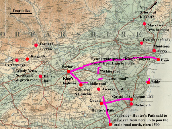
|
Approximate
course of cadger road from Usan to Forfar. The
purpose of the road was to supply fresh fish to
the palace and it was to be as wide as a mill
wand. This was a a piece of wood that went
through the hole in the centre of a mill stone
and allowed it to be trundled along on its edge.
Many local histories mention the road but not
in enough detail to reconstruct its course other
than it probably ran near Bonnyton and across
Montreathmont Moor. From there the topography
would suggest it ran along the lower slopes of
Turin Hill.
Based on quarter-inch OS map The Forth & Tay,
1923. With thanks to Ordnance Survey.
|
The fyschergate is interesting
as it has every appearance of being the “king’s
cadger’s road” which is said to have ran from
Usan on the coast to Forfar and along which the king’s
cadger had to bring fish to the court every day. Although
it is mentioned in local histories such as Warden, the
“road” itself is lost, except in general terms
of running across Montreathmont Moor. However topography
suggests that it would have headed for the western end
of Rescobie Loch and the mention of the fyschergate
adds credibility to this.
The location of the “white
road” is less certain, depending on which translation
one follows. Warden’s would suggest somewhere near
the Girdle Stone, and the other the road running south
from Cross Roads along which there is a parish boundary.
Dunnichen
(Dunbarrow)
Registrorum
Abbacie De Aberbrothoc
Vol.2, Page 66, No 73
Dunberrow
This charter gives the boundaries for Dunbarrow, which
lies to the south-east of Letham, viz:
Thir ar the merchis devydand Dunberrow
on euery syde that is to sa
betwex the landis of Gardyn, Connansyth, the Boch, the
lordschip of
Eidwy, Auchirmegyty, and the landis of Presthok (per
Walterum
abbatem anno Domini millesimo quadragintesimo tricesimo
quarto) 1434.
In the fyrst begynnand at Fallaty at the north est the
quhilk devydis
the landis of Gardyn Presthok and Dunberrow in that
part. And sua south
as the Brery Dyke gais callit the Wod Dyke to the Cartfurde
in the Denburne
devydande the landis of Gardyn and Dunberrow on the
est syide of
the landys of Dunberrow and Connansyth. And sua fra
the Cartfurde
foresaid west as the Denburne gais to the discens of
the Sclaitwel falland
in the furde of the myl of Achskorry the quhilk furde
devydis the landis
of Dunberrow the landis of Eidwy and the Boch. And sua
ewyn north to
the Blyndwel of the Stotfalde. And sua north as Dunnyte
Den (Idvis Burn) gais tyl
Owyny the quhilkis Mylfurde Blyndewel and Ovyny forsaid
devydis the
landis of Dunberrow at the west fra Eidwy and thair
Dunnyte Den in
Ovyny (Vinny Water) devydis Dunberrow at the north west
syde fra the landis of Eidwy Auchirmegyty and Presthok.
And sua furth est as Dunberrow streikis as
the Greyne Laich gais to the Greyne Rod on the north
syidis of Fallaty
quhil we cum to the landis of Gardyn at Fallaty at the
north est devydand
the landis of Gardyn Presthok and Dunberrow quhair we
begane.
Interpretation
 These
boundaries would be difficult to identify if it were
not for the fact that they describe a detached portion
of the parish of Dunnichen and are shown on early maps
(e.g. 6”
map, 1st series, Forfarshire XXXIX) . These
boundaries would be difficult to identify if it were
not for the fact that they describe a detached portion
of the parish of Dunnichen and are shown on early maps
(e.g. 6”
map, 1st series, Forfarshire XXXIX) .
From this we can see how they
start at Fallady and then run south to the Denton Burn
(Denburne) although it is not clear where the Cartfurde
was. The ford at Ascurry (Achskorry) is clearer and
may have been used to access the mill. The boundary
would then go north to the Idvis Burn (Dunnyte Den )
and near to the Vinny Water (Ovyny). The location of
the green road is unclear but must have been near the
Vinny Water and Fallady.
Dunnichen
(Craichie)
Registrorum
Abbacie De Aberbrothoc
Vol.2, Page 253, no 307
Assedacio dimidii molendini de Craquhy
Assedation (lease) of one-half of the mill of Craquhy
A charter of 1486 relating to the mill of Craquhy (Craichie)
gives the boundaries of Craichie as:
..the ville of Crachy by the undernoted divisions thus,
extending from the stone of le Furdhyll which is to be
cultivated just like Ouchtirlowny and going by the middle
road between the cultivated lands of Ouchtirlowny and
Crachy as far as the spring of Croston, the sheep fold
of le Boybrigfald, and to the water of Ovynni…
….ville de Crachy
per diuisas subscriptas prout se extendit a lapide de
le Furdhyll
colendo prout colunt Ouchtirlowny et veniendo per mediam
viam inter
terras cultas de Ouchtirlowny et Crachy vsque ad fontem
de Crostoun et
ad ouile de le Boybrigfald vsque ad aquam de Ovynni
. .
Interpretation
 Craichie
and the mill still exist and are 3 miles south-east
of Forfar on the B9128. The Furdhill is lost though
the names of Croston and Boybrigfald (Bowriefauld) have
survived as has the Water of Vinny (Ovynni). Ochtirlowny
survives in the place name Lownie just north-west of
Craichie. Craichie
and the mill still exist and are 3 miles south-east
of Forfar on the B9128. The Furdhill is lost though
the names of Croston and Boybrigfald (Bowriefauld) have
survived as has the Water of Vinny (Ovynni). Ochtirlowny
survives in the place name Lownie just north-west of
Craichie.
From the wording of the charter,
one would have an approximate course for the road from
between Craichie and Ochtirlowny and running east towards
Crosston.
Dunnichen
(Ouchyrlowny & Forfar)
Registrorum
Abbacie De Aberbrothoc
Vol.2,
Page 95, Charter 112
Perambulacio facta inter terras de Ouchyrlowny et Forfar
Perambulation made between the lands of Ouchyrlowny
and Forfar
This charter dating from 1457 details a perambulation
carried out to determine the boundary between the lands
of Ouchyrlowny (Ochtirlony) and Forfar. It reads:
Beginning
towards the south to the great stone placed as a boundary
marker on the western side of the great ford known as
le Cowfurde where the king’s muir, the abbot’s
lands, and the lands of Lowr come together, and so ascending
northwards by various bounds placed in this inspection
from the western side of the cultivated lands which
are vulgarly called le Furdhill of Crawquhy as far as
that stone vulgarly called le Porkstane and so ascending
from the said stone, also to the north, by other bounds
as far as the stream in le Gavnlydene, and so ascending
towards the west using the said stream as a boundary
until coming to le Welstrynde vulgarly called Cardynis
Well, and so ascending northwards by other bounds, also
set by the same inspection, only as far as the king’s
highway which leads from Ouchtirlowny to Forfar.
Incipiendo videlicet
versus austrum ad magnum lapidem pro
meta positum ex parte occidentali magni vadi wlgariter
nuncupati le
Cowfurde vbi mora regia et terra . . . abbatis . . .
et terra de Lowr
adinuicem coniunguntur et sic ascendendo versus boream
per diuersas
metas per ipsam assisam positas ex parte occidentali
terre culte que
wlgariter vocatur le Furdhil de Crawquhy vsque ad quendam
lapidem
vulgariter nuncupatum le Porkstane et sic ascendendo
a dicto lapide
eciam versus boream per alias metas vsque ad riuulum
in le Gavnlydene
et sic ascendendo versus occidentem et tenendo predictum
riuulum pro
marchia vsque perueniatur ad le Welstrynde wlgariter
appellatum Cardynis
Well et sic ascendendo versus boream per alias metas
eciam per
ipsam assisam positas vsque perueniatur tantum ad viam
regiam que ducit
ab Ouchtirlowny ad Forfar
Interpretation
 With
so many of the placenames lost this is a very difficult
charter to interpret. The main locations of the King’s
Muir, Craichie, and Lour survive as does the Cardynys
Well as Cardinal’s Well, and there is a suspicion
that the boundary at the extreme west of Dunnichen parish
could be that of the Ochtirlowny lands. With
so many of the placenames lost this is a very difficult
charter to interpret. The main locations of the King’s
Muir, Craichie, and Lour survive as does the Cardynys
Well as Cardinal’s Well, and there is a suspicion
that the boundary at the extreme west of Dunnichen parish
could be that of the Ochtirlowny lands.
None of this matters too much
as the king’s highway must have had much the same
line as the present day road. As noted elsewhere it
may be wiser to take the charter at face value and not
assume that it continued beyond Ochtirlowny.
Carmyllie
Registrorum
Abbacie De Aberbrothoc Vol.1,
page 322, charter 366
Conan et Tulloch limites
Bounds of Conon and Tulloch
In a charter of 1254 relating to a dispute, the boundaries
between the abbey’s lands of Conan and Tulloch and
those of Peter de Maulia of Pannemor and Christine his
wife were agreed.
The boundaries read: Beginning at the river called Eloth
and so ascending to the waste as far as the stream called
Lecach then by that waste as far as the eastern side of
Crundaly, then descending to the rock placed in the head
of Kelwad, then by a sike to the marsh of Gamell then
by a stream leading eastwards to the common road which
leads to the bounds of the land of the lord Eustach de
Baliol…….
The charter also gives the agreed boundary between Tuloch
and Pannemor as:
..a certain road which lies between Kynard and Tulach
and so descending to a certain ford which is called Athroby.
Incipiendo scilicet a rivulo qui dicitur
Eloth et sic ascendendo ad vascellum usque ad rivulum
qui dicitur Lecach et sic ascendendo per id vascellum
usque ad orientalem partem de Crundaly / et sic descendendo
ad petram que fixa est in capite de Kelwad et ita descendendo
siket ad maresiam Gamell et ita per rivulum versus orientem
usque ad communem stratam que tendit ad terminum terre
domini Eustachii de Balliol……
…..quedam strata
que jacet inter Kynard et Tulach et sic descendendo
ad quoddam vadum quod dicitur Athroby.
Interpretation
 None
of the place names other than Tulloch (Tillyhiot), Conon,
Panmure (Pannemor) and the Elliot Water (Eloth) can
now be identified, nor can the common road. None
of the place names other than Tulloch (Tillyhiot), Conon,
Panmure (Pannemor) and the Elliot Water (Eloth) can
now be identified, nor can the common road.
As Kynard in the second excerpt
from the charter cannot be identified, it is difficult
to say where the road might have been. However, it is
interesting (though speculative) to note that there
is a tradition of an old road in the area. This is the
Hunter’s Path or Heckenbois Path said to have been
made by Hector Boece the historian (1465-1536) from
his house at Panbride up to the main road north. This
road certainly passed close to Conon and Tulloch (Tullyhiot)
and would have ran through Redford which may reflect
the name of Athroby which means “red ford.”
See here for
additional information.
St
Vigeans
Registrorum Abbacie
De Aberbrothoc
Vol.2, page 67, no 75
The marchis that bundys the Myltounmwr the Eisterbrekkis
and the biscoppis land of Sanctandros.
In the fyrst begynnand at the Ramdenheid and fra thyne
passand sowth
vest to the Todholis and swa furth to the Akyn Busk (prob.
oak & bush/thicket
- see DSL) and swa one to the Blynd or the Beld Stane
ondyr the dikys of the
Brakkys and swa on to the Denheid of Gutheryne ondyr the
gait as the
induellaris of Gutheryn cummys and gays to Sanct Vigianis
kyrk.
Interpretation

St Vigeans lies about a mile and a half north of Arbroath.
The boundaries are quite difficult to follow although
one recognises Brax (Brekkis) and Guynd (Gutheryne),
and the Denheid of Gutheryne may be what is now called
Denhead of Arbirlot. David Miller in Arbroath and Its
Abbey (1860), page 205, considers that these marches
are identical to the north boundary of Arbirlot parish
from the head of the Ram Den to the Elliot water.
A fairly straight track can be
assumed from Gutheryne (Guynd) to the church.
Inverkeilor
Registrorum Abbacie
De Aberbrothoc Vol.2,
page 479. no 688
Athe (Ethie) (7 miles nth of Arbroath)
 This
is a lease of land on the north side of the Mains of Ethie
dating from 1527. It includes the phrase “to be personally
occupied and laboured by the said John, swa that he be
nocht inquyet be hys nychtborrys makand common gayt throw
hys toft…” This
is a lease of land on the north side of the Mains of Ethie
dating from 1527. It includes the phrase “to be personally
occupied and laboured by the said John, swa that he be
nocht inquyet be hys nychtborrys makand common gayt throw
hys toft…”
Vol.2 Page 483, No.698 Athe (Ethie)
This document of 1528 refers to “half of the lands
of the Manis of Athe with the teind sheaves in the sheriffdom
of Forfar and regality of Arbroyth, at the sowthfyid
of the sayd Manys that ys to say fra the hauyne of Athe
haldand west the common gayt to the well in the town
of the sayd Manys and frathynfurth euyn west the loyn
to ane othir well callit the Greyn Well….”
Interpretation
The hauyne of Athe is now called Ethie Haven. The charter
implies there was a track from the Haven to Ethie Mains,
and then another (the loyn or loan) westwards - the
Greyn Well may have been at Ethie Greens as shown on
the 6”map (Forfarshire
XLI).
Marykirk
Registrorum Abbacie
De Aberbrothoc
Vol. 1, Page 100, charter 144
Cirographum William aucupis
Chirograph of William
the Fowler (Hawker/Falconer)
This is a record of
an agreement that mentions two bridges. The location is
either Maryton near the Montrose Basin or Marykirk on
the North Esk.
"With the question turning
between the Abbot and convent of Aberbrothoc on the
one hand and William the Fowler on the other on whether
a certain portion of land between the villa of the same
William and Maringtun which land is situated from the
western side of the bridge of Luffenoct and extends
next to a certain bridge which is called stanbrig….."
Cvm questio verteretur
inter Abbatem et conuentum de Aberbrothoc ex
vna parte et William aucupem ex altera super quadam
porcione terre inter
villam eiusdem William aucupis et maringtun que terra
iacet ab occidentali
parte pontis de luffenoct et pertenditur iuxta quisdam
pontem qui dicitur stanbrig
Interpretation
 The
Maringtun of the document (undated but probably early
to mid 1200’s) has been identified by some with
Maryton on the south side of the Montrose Basin, and
by others with Marykirk some 6 miles to the north on
the River North Esk. The topography favours Marykirk
because it used to be known as Aberluthnot, and the
document mentions the bridge of Luffenoct. The
Maringtun of the document (undated but probably early
to mid 1200’s) has been identified by some with
Maryton on the south side of the Montrose Basin, and
by others with Marykirk some 6 miles to the north on
the River North Esk. The topography favours Marykirk
because it used to be known as Aberluthnot, and the
document mentions the bridge of Luffenoct.
In a footnote on page xxv the
editors of the Register say:
“The charter has several minute particulars of
curiosity for the local antiquary. The land in question
lay to the west of the bridge of Luffenot, apparently
the Luthnot Burn (the footnote says the Luther Water
but at the end of vol.2, this was changed to Lethnot
Burn) and extended to a certain bridge called Stanbrig,
which appears certainly to have been a bridge of stone
over the North water, a very early example of a bridge
over such a stream. The land was granted to the church
of Maringtun, apparently Marykirk; and as a symbol of
investiture, the Falconer offered a turf of the land
upon the altar of the Church.”
Although the Luthnot Burn is not
named on any map it is generally said to have flowed
through or very near Marykirk - the likeliest candidate
would therefore be the Balmaleedy Burn. There is a definite
possibility that the stone bridge was not over the North
Esk but rather over the Luther Water or even the Balmakelly
Burn.
Note:
A chirograph
(cyrograph) is a medieval document, which has been written
in duplicate, triplicate or very occasionally quadruplicate
on a single piece of parchment, where the Latin word
"chirographum" (or equivalent) has been written
across the middle, and then cut through. By this means
both parties to an agreement could possess a copy of
its written record, and each copy could be verified
as genuine through introduction to, and comparison with,
the other. (Wikipedia)
Kingoldrum
Registrorum Abbacie
De Aberbrothoc
Vol. 2, Page 103, no.121
Kyncoldrum limites incipiendo ad austrum per Malcomum
abbatem
anno 1458.
The bounds of
Kyncoldrum beginning at the south, by Malcolm, Abbot,
1458
This charter notes the boundaries of the lands owned
by Arbroath abbey in the Kingoldrum area in 1458. In
fact a close examination shows that they are identical
to the parish boundary although if this was not marked
on maps it would be very difficult to work out where
the charter boundaries ran as many of the place names
are lost and the descriptions very vague in places.
The charter is of interest for
its mentions of three fords, viz.
The bwrne furd of Artheragy
- and swa north to Drumnagub that partis Kenny Lytil
and Schangly and wp to the bwrne furd of Artheragy the
quhilk partys Baldewy and Kynclwn (3156) fra Kennard
(2954) and fra Pergawy (3055) and fra thyne passand
wp to the west part of Mydfield that partis Kynclwne
and Pergewy….
 From
this context the ford must have been very near to the
farm of Wardend. The orientation of the associated track
could have been N-S or E-W; it was probably used for
local access From
this context the ford must have been very near to the
farm of Wardend. The orientation of the associated track
could have been N-S or E-W; it was probably used for
local access
The Brandyrfwrd and the Cowfurd
- up the bwrne of Haldyrischanna that is to say the
Gled Bwrne and wp to the bwrne of Aldalane syne wp north
to Carnecaithlay syne eist the north part of Carnecaithla
to the vattyr of Prossyne and syne sowth to the Brandyrfwrd
and sowth owr the end of the Clwne to the Cowfurd and
fra the Cowfurd to the marche reisk and sowth fra thyne
to ane well and fra thyne to ane crosstane in the sowth
syd of Dromakalyow….
Two fords are shown on this stretch
of the Prosen on the early 6“ map: one at Glackburn
and one at Prosenhaugh. These could be interpreted as
one or both of the fords, but the description is so
obscure that additional information would be needed
to reach any certainty. Where the boundary turns sharply
south, there is in fact a well near Balloch and a nearby
hill is called Clune Hill suggesting the Carrity Burn
was called the Clune. The place name of Balloch may
suggest an early route through the area.
G W S Barrow in 'Land Routes:
The Medieval Evidence', in Loads and Roads in Scotland
and Beyond, ed. A.Fenton & G.Stell, 49-66, Edinburgh
1984 (John Donald) refers to four fords in Kingoldrum
mentioned in an unpublished chartulary of Arbroath abbey
(BL MS Add. 33245 ff.179-80). The fords are Dersy (see
next charter), Aquhragy, Madzor, and Achnahilt on the
Carity Burn. He identifies Aqhragy as Ascreve though,
as we have seen, its location must have been on the
western side of the parish rather than to the east where
Ascreve lies. Although the names are quite different
there is a slight possibility that the Brandyford and
the Cowford are Madzor and Achnahilt - this would allow
us to place the Cowford on the Carity Burn.
In the fyrst begynnand at the sowth
at Carghal and passand vest to Melgone
• and fra thyne ascendand to the north to Myllaschangly
that is to
say Scottismyll tyll ane strype at the west part of
Lytil Kenny the quhilk
stripe deuydis it fra Myllaschangly • and syne
haldand north to Monybrek
that is to say marrass of the quhilk rynnis ane strype
to Melgone the
quhilk deuydis Litil Kenny fra Myllaschangly •
and swa north to Drumnagub
that partis Kenny Lytil and Schangly and wp to the bwrne
furd of
Artheragy the quhilk partys Baldewy and Kynclwn fra
Kennard and
fra Pergawy • and fra thyne passand wp to the weft
part of Mydfield that
partis Kynclwne and Pergewy • and swa wp to the
bwrne of Athyncroith
that is to say the Gallaow Bwrne the quhilk diuidis
Kynclune and Pergewy
• and swa wp to the Raistane Well diwidand betuix
Kynclwne and
Pergewy • and syne north west to Tybyrnoquhyg that
is to say the Blynd
Well • and swa wp to Carnofotyr that is to say
the Pwndiris Carne • syne
eist to the corstane abwne Cargfuryngis betuix Kynclwne
and Garlay
and eist the north part of Tarrak tyl ane othyr corsstane
• and syne eist
the north part of Claischnamoyll that is to say the
Mekylhyll and tyll ane
corsstane of Claischnamoyll • and fra thyne to
the pwll of Monboy that is
to say the Yallow Pwlle • and swa wp the claische
that is to say the reyske
haldand eist to the corsstane • and swa up the
bwrne of Haldyrischanna
that is to say the Gled Bwrne and wp to the bwrne of
Aldalane • syne wp
north to Carnecaithlay -• syne eist the north part
of Carnecaithla to the
vattyr of Prossyne • and syne sowth to the Brandyrfwrd
and sowth owr
the end of the Clwne to the Cowfurd and fra the Cowfurd
to the marche
reisk • and sowth fra thyne to ane well •
and fra thyne to ane crosstane in
the sowth syd of Dromakalyow • and fra thyne sowth
owr the Lowth to the
quhit stane in the eist syd of Egnowe • fra thyne
sowth owr to Leiftye.
Kingoldrum
Registrorum
Abbacie De Aberbrothoc
Vol. 2, Page 104, No. 122
Kyncoldrum limites vnius partis per Malcomum abbatem anno
1458.
The bounds of part of Kyncoldrum,
by Malcolm, Abbot, 1458
Thir ar the marchis betuix ane part
of Kyncoldrum Kynnordy and
Drumnacalyowcht. In the fyrst begynnand at the crosstane
apon the vard
dyk of Drumnacalyowcht sowth owr the Lowth to the stannand
stanis of
the eist syd of Egnoch and swa sowth owr tyll Achyndory
and to the
furd of Dersy vest the greyn rod quhill it cum to the
Scotisgait and
swa north to the Vynddy-yettis and fra thyn north owr
athowrt the mwr
tyll ane strype rynnand throw Rwscha to the vattar of
Crummy and fra
thyne vest to the Inner of Melgone and fra Melgone wp
to the Scottismyll.
Interpretation
 Much
of this is shown by parish boundaries except for the
section between Dersy and the Vynddy-yettis which mentions
the roads. Drumnacalyowcht is now Culhawk Hill with
the parish boundary on its western side. The Louth is
the stream that ran into the Loch of Kinnordy with Egnoch
or Egknowe to the south. Again the parish boundary runs
through these places and down to Achindorie and present
day Dairsie. Much
of this is shown by parish boundaries except for the
section between Dersy and the Vynddy-yettis which mentions
the roads. Drumnacalyowcht is now Culhawk Hill with
the parish boundary on its western side. The Louth is
the stream that ran into the Loch of Kinnordy with Egnoch
or Egknowe to the south. Again the parish boundary runs
through these places and down to Achindorie and present
day Dairsie.
Leaving aside the uncertain middle
section we can pick up the boundary at Rwscha which
is shown on Gordon’s map of Braes of Angus as Runsche.
This was near the confluence of the Cromie Burn and
the Melgam Water. Melgone was nearby and the Scottismyll
or Myllaschangly was near Shannally on the Melgam Water.
 |
| Kaims of Airlie. This rough
terrain which is glacial in origin may hold a clue
to the name of Windy Yetts as it would have forced
people to take a winding path. |
Although we have an approximate
north-westerly course about four miles in length for
the middle section, it is probably best not to speculate
too much, intriguing though the names of Scotisgait
and Windy Yetts are. There is, however, a possibility
that the Scotisgait is the Roman
road which was picked up at Westmuir and ran close to
Reedie (OGS Crawford, Topography of Roman Scotland,
page 90, NMRS
records). The stripe, or small rivulet, can
be seen on the parish boundary running into the Cromie
Burn.
A charter for Coupar Angus abbey
gave them free passage across the land of Achindory
- see here.
Dun
Registrorum Abbacie
De Aberbrothoc Volume
2, Page 109, charter 124

This charter concerned a toft somewhere between the
north of Montrose and the Dun, namely: "our toft
with messuage tending in its length from Stanefurde
to the torrent of the Dun….lying in the lordship
of Dun between the land of the brethren of Montrose
on the north side of the same and the lands of the brew-house
of Dun on the southern side of the same…."
toftum nostrum cum
massuagio tendens in longitudine a Stanefurde vsque
ad torrentem de Dvn . . . iacens in dominio de Dvn inter
terram fratrum de Montros ex parte boriali eiusdem .
. . et terram Brasine (brew house) de Dvn ex parte australi
eiusdem 1459
Interpretation
Apart from the place name of Staneforde being lost,
the mention of the brethren of Montrose adds a complication
if the Dominican Friars are being referred to. They
had a friary to the north of the town but this is too
far from the water of Dun to fit the charter. If they
had land in the vicinity of Dun, one could imagine the
“Stanefurde” also being in that area though
from the description (from the Stanefurde to the torrent
of the Dun) it may have been over a stream other than
the Dun.
Lindores
Abbey
Newtyle
William Wascelyn's Charter of the Land of Newtyle
Chartulary
of Lindores, charter XXXVII, page 39.
Notes, page 247. Date c.1200
POMS: 3/602/1
 |
| Parish boundary in green. Based
on half-inch Ordnance Survey map, sheet 24, 1914
with thanks. |
William Wascelyn and Mabel, his
wife, gave Lindores abbey "an oxgate of land in
the vill of Newtyle, namely between the high way (superiorem
viam) and the hill" along with common pasture with
their own men for various animals.
A footnote as well as Notes (p. 247) suggests the sense
of superiorem uiam may be "upper road."
Interpretation
As it stands there is insufficient information to
tell where this road might have been other than to the
hilly ground south of Newtyle. Assuming a "lower
road" is implied, such a "lower road"
may have been an early route to Dundee.
St Andrew's
Cathedral Priory
Easter
Fowlis
Carta William Masculi de foules;
Carta Rogeri Mortimer de foules
St
Andrew's Liber, p.40 & p.41
POMS
A charter for Easter Fowlis refers to a grant of the
church and some land in Easter Fowlis to Thomas the
clerk and nephew to William Masculi (Maule), and confirmed
by William's successor, Roger Mortimer, in another charter.
The boundaries are practically
the same in each charter. William says he gives the
church "with church lands from the stream which
descends to my mill by the road towards fofar (Forfar)
as far as a certain division which is in the eastern
part of the chutel (Cuthill), and so by the previously
noted division as far as a stone below the lesser meadow
and so to the foresaid burn. I concede also to God,
the Church and the foresaid person, certain lands on
the western side of the village to the exit for the
animals between the road and the burn as far as the
blakford."
This part of Roger's charter is
practically identical. He has forfar instead of fofar
and Cuthel instead of Chutel, and "below the lesser
meadow of the church". Cuthill is a grove or small
wood (DSL)
cum terra ecclesie
a riuo que descendit ad molendinum meum per viam aduersus
fofar vsque ad quondam diuisam que est in parte orientali
de chutel, et ita per prenotatam diuisam vsque ad lapidem
sub minore prato et sic vsque ad predictum riuulum.
Concessi eciam deo et ecclesie et predicte persone terram
quandam ex parte occidentali ville ad exitus animalium
inter viam et riuulum vsque ad blakford.
Interpretation
 |
| The area described by the charter
probably lies close to the centre of the village
with its church, mill and castle |
Fowlis Easter lies some 6 miles
west of Dundee. Although none of the placenames have
survived we can be fairly confident the charters are
dealing with land very close to the village itself.
We have a burn running through Fowlis, a mill which
although it dates from 1668 could easily have replaced
one that was earlier, and the church nearby. There is
also a ford downstream from the village.
However, none of this is very
helpful in identifying the road to Forfar and early
maps show nothing feasible. One possibility is that
the road ran east to intersect a north-south route between
Dundee and Forfar; another that it went directly to
Forfar by crossing the Sidlaw Hills but both these possibilities
are very vague. Nor is it clear what the purpose of
the route might have been.
Kirkden
Ordinacio Walteri episcopi de Edwy
St
Andrews Liber, page 409
Alex.
J. Warden, Angus or Forfarshire, Vol. IV, page 67
In volume IV of Angus or Forfarshire,
the author Alex. J. Warden notes that the St Andrews
Liber (page 409) records that Walter, the Bishop of
St Andrews "made a visitation to the church in
1388, and issued an ordinance for changing the site
of the manse of Idvies. The new ground is described
as bounded on the east of the church by a ford upon
the Vuany, at a heap of stones near the foot of the
rock called Craignacre. The old kirk stood upon the
lands of Gask in a field called the Kirk-shed."
Interpretation
The likeliest identification for Craignacre is Crag
Monichree which is situated below the glebe and 18th century
church of Kirkden (now a house). The Vinny Water runs
nearby where the ford would have been. It, and any associated
track, were very probably of local use only. All locations
can be seen on the 6" map. 1st series. Angus or Forfarshire,
Sheet
XXXIX
Top
|