|
Dumbarton
The OPS
notes that "a highway (magna via, via Regia) led, at
a very early period, from Dumbarton up the valley of
the Leven, probably to the earl�s (of Lennox) castle
of Balloch."
OPS, Vol.1, page 25
Reg.
de Passelet, page 215
Bonhill
A charter detailing boundaries in Bonhill includes a
reference to an old causeway, viz. "the whole land of
Buchewl in Lewyne, lying between the rivulet which is
called Pocheburne and the Blindsyke on the north side
of Carmane and so descending to the Halyburne and from
the Halyburne to the old causey which lies beyond the
moss and descending thence to the water of Lewyne."
OPS, Vol.1, page 37
Reg.
de Levenax, page 51
In the register of Paisley
Abbey, Pope Clement IV in 1265 confirmed a grant, viz.
"by the gift of the Earl Maldover of Lennox, that fishing
upon the water of Levyn which is called Linbren (in
Balloch) with the land between it and the highway to
Dumbarton�"
OPS, page 70
Reg.
de Passelet, page 310
Identification
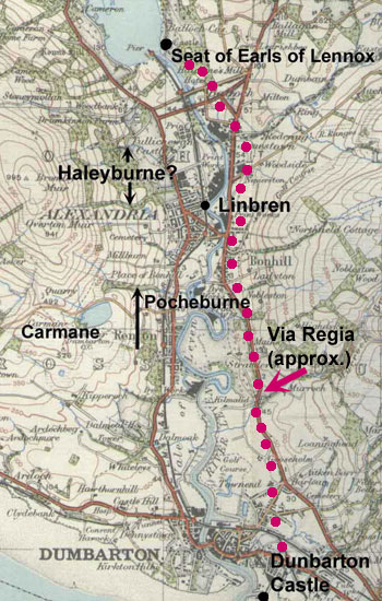 |
| Map based on 1925 1" OS
map. With thanks to Ordnance Survey |
Carmane is undoubtedly Carman
a mile or so west of Renton with a Peachy Glen nearby
(see 6" map for Dunbartonshire,
Sheet XVIII). In fact the boundary for Bonhill parish
runs up this glen. The Blind Syke and Halyburne do not
appear on any of the early maps, however the OPS contains
a map which shows what must be the boundaries of this
grant running down one of the streams west of Alexandria
towards the Leven.
The OPS map also shows the
via regia running on the east side of the Leven between
Dumbarton and Balloch and places Linbren close to the
centre of Alexandria (there is a Lambrain Cottage on
the old 6" map, Dunbartonshire, Sheet XVIII in Alexandria).
It has to be noted there is
a slight ambiguity in the charter that mentions the
Haleyburne. The wording "descending to the Halyburne
and from the Halyburne to the old causey which lies
beyond the moss and descending thence to the water of
Lewyne" could be interpreted to mean that the causey
was on the west bank of the Leven rather than the east
or even that the boundary followed the causey down to
the Leven in a west-east direction over what was undoubtedly
marshy ground at that time. Having said that, the wording
of charters is often vague and a highway on the west
bank would require two unnecessary crossings of the
Leven.
It is not clear what the origin
and purpose of the highway was, though the OPS remark
that it probably went between Dumbarton and the Earl
of Lennox�s castle at Balloch seems reasonable enough.
The reference to the "old calsey" indicates a paved
road and that it already existed when the Earls of Lennox
moved from Dumbarton to Balloch Castle in the early
1200s. It is interesting to speculate as to whether
it dates back to Strathclyde times or even earlier.
There is a tradition of a Roman
fort at Dumbarton (and/or Dumbuck nearby) and it
is only six miles from Balloch to the first century
fort at Drumquhassle, near Drymen. However, in the absence
of more definite evidence this can only be speculative.
Exemptions from
"prises and carriages"
The OPS refers to lands in the Deanery of Lennox, viz.
Luss & Arrochar and Strathblane being exempted from
the requirement to find supplies for the progresses
of the royal household in these territories. No particular
roads or routes are mentioned.
Kirkintilloch
In the Registrum
Monasterii de Cambuskenneth, published by The Grampian
Club in 1872, a reference is made in the preface to
a gift made to the abbey in the early 1200's by William
Comyng, Earl of Buchan. This was of the church of Kirkintilloch
and one oxgate of adjoining land on the east side of
the churchland (p.xxx). It was added to by John Comyng,
probably at the end of the 13th century, who gave the
abbey land adjoining the original oxgate and free entry
to gather peats, as follows:
......the whole land adjoining
that oxgate, between Luggy and Buthlane, cultivated
and uncultivated, as far as the said oxgate of land
extends, with one acre of land on the east side of the
said oxgate . . . with thirty cartloads of peats, to
be received each year at the sight of the bailie of
the burgh of Kirkintilloch, in our peat-moss of Kirkintilloch,
which at our instance our men of Kirkintilloch unanimously
granted for ever to these canons, and their tenants
whomsoever dwelling on the said land, in our open court
of Lengze, we there confirming for ever, for us and
our heirs, the foresaid lands, with the peats foresaid,
to these canons: To be held and possessed in free, pure
and perpetual alms, with free and peaceable entry and
exit, as well to the said peat-moss as to the said oxgate....(Extract
from page xxxi of the Register)
Interpretation
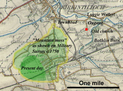 |
| Based on the 1"
OS map. Glasgow District, 1914. With thanks to Ordnance
Survey. |
The locations are easily seen
even on fairly recent maps such as the 6"map, 1st
series (Dumbartonshire,
Sheet XXIV, XXV).
The old church with its burial
ground is indicated on the map with the placename Oxgang
(= oxgate) to its east. The land was bounded by the
Luggie Water and the Bothlin Burn.
The peat-moss is what is now
called Lenzie Moss. Due to farm drainage and housing
it is much less extensive than it was, as can be seen
on the Military Survey map, c.1750. Even at that time
it would have been easily accessed from Townhead.
For more information on Lenzie
Moss see Friends
of Lenzie Moss - this includes a history and a map.
Top
|