Balmerino
Abbey
Overview
Balmerino was a Cistercian abbey founded c. 1227 by
Ermengarde de Beaumont, widow of William the Lion, and
her son Alexander II, and settled by monks from Melrose.
It is situated on the south side of the Tay nearly opposite
Dundee.
Several routes are mentioned in its charters. One was
a right of way to a quarry at Nydie, part of which may
have been used to access St Andrews. There was another
via regia between Cupar and St Andrews and one passing
through The Gauldry to Portincrag. A local road or track
developed between the abbey and Coultra, a couple of
miles south of the abbey; and there was one between
Anstruther and Crail.
A via regia at Kedlock, north of Cupar, ran from Cupar
towards the Tay; it is picked up again in a charter
for Kinnear, in Kilmany parish. Also in the Kinnear
area, there may have been a road parallel to the Mottray
Water, and one giving access to The Gauldry.
Additional information:
•
The
Chartularies of Balmerino and Lindores,
W. B. D. D. Turnbull, Abbotsford
Club 1841
• Further
details of charters pre-1314 can be found on the People
of Medieval Scotland website, see Balmerino
charters. Amanda Beam, John Bradley,
Dauvit Broun, John Reuben Davies, Matthew Hammond, Michele
Pasin (with others), The People of Medieval Scotland,
1093�1314 (Glasgow and London, 2012) www.poms.ac.uk.
The maps for Balmerino charters are
based on the 1926 one-inch map for Dundee & St Andrews
and the
1914 OS half-inch map, sheet 24. With thanks to Ordnance
Survey.
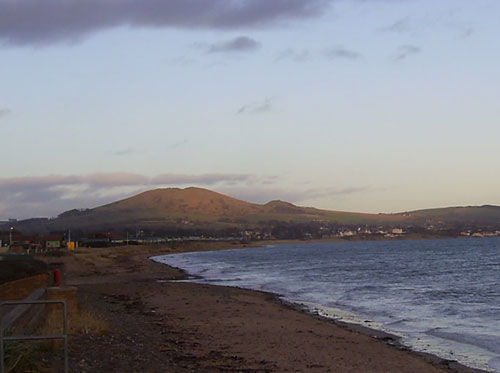
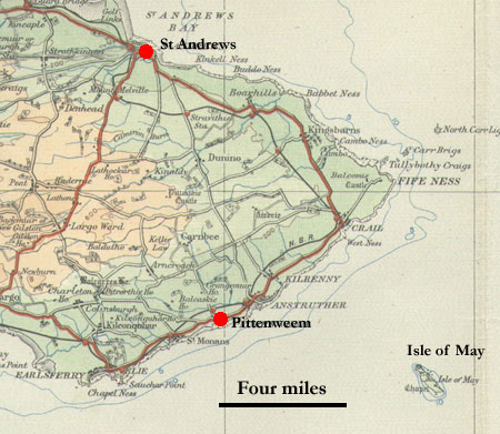
Nydie
Quarry near Strathkinness
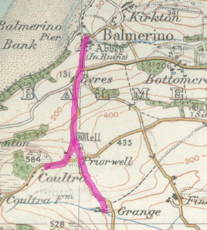
Charters
46/47/48
 |
| Balmerino abbey |
In
the early 1200's Balmerino Abbey, was granted rights
to quarry stones at Nydie near Strathkinness, four miles
west of St Andrews, and transport the stones to the
abbey for use in building.
 |
| Click on map for larger image.
Based on the 1926 one-inch map for Dundee &
St Andrews. With thanks to Ordnance Survey. Campbell
quotes a tradition that there was a branch from
near Brighouse, two miles east of Kilmany, over
to Guard Bridge and St Andrews |
The route taken by the monks between the quarry and
the abbey is discussed in a paper by R Fyfe Smith and
Rev. Norman M Johnston (Quarry to Abbey: an Ancient
Fife Route) which was published in the Proceedings
of the Society of Antiquarians in Scotland. It also
identifies the segments that still remain of the road.
Campbell (Balmerino & Its Abbey, p.135) also mentions
the road, and has the same route to near Brighouse but
then crossing over to the Gair (Guard) Bridge and St
Andrews. He quotes tradition for it linking to St Andrews
but it is not clear what its route from Brighouse might
have been - one feels it would have been easier to continue
on towards Nydie and then cut over to the Guard Bridge.
The
authors also refer to a via regia between Cupar and
St Andrews mentioned in another Balmerino charter (no.50
- see Nydie below).
As
the route to the quarry has been fully dealt with in
that paper and also by Owen Silver in the Roads
of Fife we will restrict ourselves to providing
a map of the route as determined by Smith and Johnston
and some relevant references.
Additional Information
•
Balmerino and Its Abbey, James Campbell, Edinburgh,
1868, page
92; see
also page 135
• Quarry
to Abbey: an Ancient Fife Route, R Fyfe Smith and
Rev. Norman M Johnston. PSAS, Vol 83 (1948-49), pps
162-167
• The
Roads of Fife, Owen Silver, John Donald Publishers Ltd,
Edinburgh 1987
Nydie
Charter 50, page 38
Donacio Ricardi de Nidyn de quodam tofto
Gift of Richard de Nidyn of a toft
 |
| Medieval route between Cupar
and St Andrews. Click for larger image. |
On page 91 of Balmerino and its abbey, Campbell says
that:
Richard de Nidyn with consent of his wife Amabilla grants
a portion of land in his tenement of Nidyn, which is
"bounded on the east by the landmark placed there,
on the west by the cattle road leading from Nidyn, on
the north by the King's highway leading to the city
of St Andrews and on the south by the great moor."
He gives also grass for two cows one horse and sixty
sheep on the common pasture of Nidyn.
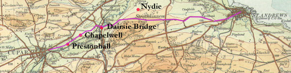
Interpretation
This is the road R Fyfe Smith and Rev. Norman M
Johnston refer to as the King's Highway to St Andrews
(p.166). There is little reason to doubt that it would
be the same as that shown on Adair's
1684 map of the east part of Fife. This left
Cupar and ran east through Prestonhall and Chapelwell
to Dairsie Mains (part of the course is now farm tracks)
where it crossed Dairsie Bridge. This was constructed
c.1522, replacing an earlier bridge and presumably an
earlier ford (see Canmore
record). From there it had the line of the existing
minor road past the location of the charter to Strathkinness
and St Andrews.
Galuran
(Gauldry)
Charter 51, page 39
Concessio Johannis de Haya de Athnauthan de Galuran
Balmerino
 |
| Based on the 1926 one-inch map
for Dundee & St Andrews. With thanks to Ordnance
Survey. |
On page 96 of Balmerino and Its Abbey, Campbell
says that between 1328 and 1332 John de Haya lord of Athnauthan
(Naughton), in settling a long standing dispute between
his family and the abbey over some ground between his
land of Galuran (Gauldry) and the abbey land of Duchwarner
(Dochrone), made the land over to the abbey in this charter.
Campbell gives the boundaries of the land thus: Beginning
on the west side of the village of Galuran where his land
and theirs meet, and extending eastward along the ancient
King's highway leading to the Ferry of Portinkrag; and
from the said highway southwards in a straight line to
a certain well called �Bridiis Well;�(Canmore
record) and thence to a certain stone lying on the
moor; and thence to the marches of Kilmanyn; and thence
to a certain footpath called Scongate; and then ascending
along this footpath to the west side of Galuran already
mentioned.
Interpretation
Although the placename of Dochrone has disappeared,
Campbell says that it was just south and west of Gauldry.
He also says that a well in Gauldry itself, and south
of the main road, fitted the description of St Bride's
Well. It is shown on the 2nd series 6" map (Fife
& Kinross Sheet
III.se).
Both these points fit the description of the charter
quite well. One would start on the main road just west
of Gauldry, follow this to a point north of the well
then proceed south to the well and beyond this to the
parish boundary which is quite near. From there one
would go west to hit a footpath and follow this northwards
to the starting point. There is in fact a footpath at
or near this location.
From this it is clear enough that the main road is
the king's highway leading to Portincraig though it
is not at all clear where it was coming from or indeed
what its route was after leaving Gauldry.
The footpath above may be the Scongate though it is
not clear why it has this name. There is a Gaelic word
"sgonn" which has a meaning of a shapeless
mass or a lump or block, perhaps referring to a local
landform but this is speculative.
Cultra
Carta Henrici Reuel et Margarete sponse eius de terra
de Balmurinach
Charters of the Priory of St Andrew, page 271
 |
| Based on the 1926 one-inch map
for Dundee & St Andrews. With thanks to Ordnance
Survey. |
On page 26 of Balmerino and Its Abbey, Campbell says that:
Henry de Reuel and Margaret his spouse granted to the
Priory of St Andrews fifteen acres of land which are described
as lying north of Cultra, and west of the road leading
from Balmerino to Cultra, as perambulated by the said
Henry Richard Reuel, his nephew Matthew the canon and
his good men, and also the common pasture pertaining to
that extent of land
Interpretation
This must on the same or similar line to the existing
road between these places. As there was a grange less
than a mile to the south of Cultra, it is likely the
road extended to that point.
Anstruther
Charter 49, page 37
 Campbell
in Balmerino and Its Abbey (page 96) says that William
de Candela granted the abbey some land on the east side
of Anstruther between the Crail road and the sea. Campbell
in Balmerino and Its Abbey (page 96) says that William
de Candela granted the abbey some land on the east side
of Anstruther between the Crail road and the sea.
Interpretation
Both Adair in 1684 and the Military Survey c.1750
show the road between Anstruther and Crail as having
very much the line of the present day road which is
about half a mile from the sea.
Kilmany
(Kinnear)
A group of Balmerino charters (Charters 12 -18) deal with
lands in Kinner, now Kinnear, 3 miles ESE of Balmerino.
Of these, charters 16 and 18 mention (the same) roads.
Charter 16 was a gift by Simon, son of Simon of Kynner,
to the hospital of St John the Baptist of Jerusalem
of six acres of land in the western ville of Kynner
with a certain house and adjacent croft which Mertham,
son of Mertham, held on the west side of the Brigflat.
Three of the said acres led from the house to the other
road and three acres from the western side of the house
led to the marsh. Common pasturage for eighty sheep
with their lambs from one year, four oxen, four cows
and two horses was also granted.
……sex acras terre in occidentali
villa de Kynner cum quadam domo quam Mertham filius
Mertham tenuit cum crofto propinquiores le Brigflat
ex parte occidentali. Tres scilicet acras tendentes
de domo usque ad alteram viam et tres acras ex occidentali
parte domus tendentes usque ad marescum cum communi
pastura maresium octoginta ovium cum sequela sua unius
anni et quatuor boum et quatuor vaccarum et duorum equorum
……….
Further on in this charter, a special condition was
included, that Hugo of Kilmanyn could hold this land
on payment to the hospital of 12d annually. The grant
is described as: the foresaid house with the said six
acres of land, or another house and another six acres
of land in Easter Kynner, namely the house near to the
house which Mertham held with a croft, and two acres
with crofts below the house leading to the road, and
four acres below the road leading to the marsh along
with the previously noted appurtenances, liberties and
easements…
…….predictam domum cum predictis
sex acris terre, vel aliam domum et alias sex acras
terre in orientali villa de Kynner, domum scilicet propinquiorem
domo quam Mertham tenuit cum crofto, et duas acras cum
croftis sub domo tendentes usque ad viam, et quatuor
acras sub via tendentes usque ad mariscum cum prenominatis
pertinenciis et libertatibus et aisiamentis…….
Charter 18 notes that at a later date Hugo granted the
land, the croft and the pasture rights to Balmerino
Abbey provided they paid the 12d. to the hospital. The
land is described as:
…six acres of arable land in wester Kynner with
a certain area for the construction of a building where
there used to be a house which Mertham son of Mertham
held along with a croft adjacent to the west side of
the Brigflath. Three of the acres led from the foresaid
house as far as the other road, and three acres from
the west side of the foresaid house leading to the marsh
with common pasture for 80 sheep and their lambs for
one year, four oxen, four cows and two horses…
……sex acras terre arabilis
in occidentali villa de Kynner cum quadam area ad construendum
edificium ubi domus esse consuevit quam Mertham filius
Mertham tenuit una cum crofto propinquiores le Brigflath
ex parte occidentali. Tres scilicet acras tendentes
de domo predicta usque ad alteram viam et tres acras
ex occidentali parte domus predicte tendentes usque
ad maresium cum communi pastura octoginta ovium cum
sequela sua unius anni et quatuor boum et quatuor vaccarum
et duorum equorum…..
This is practically the same as the first entry in charter
16 above although Mertham's house had gone.
For further information on the charters
see:
The
Chartularies of Balmerino and Lindores, W.
B. D. D. Turnbull
Balmerino
and Its Abbey, James Campbell, 1868. Page 90
POMS All
Kinnear charters; charter
16; charter
18
Placenames of Fife, Simon Taylor with Gilbert Markus,
Vol. 4, pps 446-449
The medieval marches of Wester Kinnear, Kilmany Parish,
Fife. Simon Taylor & Michael Henderson: Tayside and
Fife Archaeological Journal, 4. pp. 232-247.
 |
| Based on the 1926 one-inch map
for Dundee & St Andrews. With thanks to Ordnance
Survey. |
Interpretation
Kinner is now Kinnear, 3 miles ESE of Balmerino.
There is still a Wester and an Easter Kinnear. Other
charters (Balmerino charters 12 -14) give the overall
boundaries of this land and have been translated by
Campbell ( Balmerino
and Its Abbey, page 83) and studied in detail by
Taylor and Henderson. While these charters do not mention
any roads, a previously unknown charter does mention
one, which they identify as the road between Cupar and
Woodhaven. This is shown on the Military Survey map
and must be the continuation of the via regia mentioned
for Kedlock.
In addition to this road, we know that there was a
route that ran from Balmerino via Gauldry to Nydie and
St Andrews - this passed between Kilmany and Wester
Kinnear. This leaves us with the task of identifying
three roads from charters 16 and 18: "the other
road", the road to the marsh, and the road which
was distinct from "the other road".
The road to the marsh is said to have been on the west
side of the house (charter 16) and was probably marshy
ground near the Mottray. The "other road"
is difficult. It may have been the old track mentioned
by Taylor and Henderson that ran from Kinner to The
Gauldry and so Balmerino. The road distinct from "the
other road" could suggest a track parallel to the
Mottray which would connect the east and west parts
of the estate and to Kilmany and the Cupar road on the
south-west.
Logie (Kedlock)
Dealt with under St Andrews Priory, see here.
A via regia is mentioned that ran north from Cupar to
the Tay, as well as a road near a hill called Adkar.
Dundee
Charter 33, page 26
This charter mentions the "via maris de Dunde"
Lindores
Abbey
Overview
This was a Tironensian abbey founded as a daughter house
of Kelso in 1191 by David, Earl of Huntingdon, younger
brother of William I (the Lion) and grandson of David
I. Its attractive ruins lie just east of Newburgh, near
the river Tay.
Of roads mentioned in its charters the only local road
was a right of way from a petary in the south of Collessie
parish, and which passed through the village of Collessie.
In Perthshire there was a road in Newtyle; and in Aberdeenshire,
a bridge just north of Inverurie, a road that may have
led from Inverurie to Huntly, and a local road in Rathmuriel.
• Chartulary
of the Abbey of Lindores 1195-1479,
Right Rev. John Dowden, D.D., Bishop of Edinburgh on
Internet Archives.
•
The Roads of Fife, Owen Silver, John Donald
Publishers Ltd, Edinburgh 1987
•
People of Medieval Scotland website. This has
details of charters pre-1314, see Lindores
charters. Amanda Beam, John Bradley, Dauvit Broun,
John Reuben Davies, Matthew Hammond, Michele Pasin (with
others),The People of Medieval Scotland, 1093�1314 (Glasgow
& London, 2012),www.poms.ac.uk.
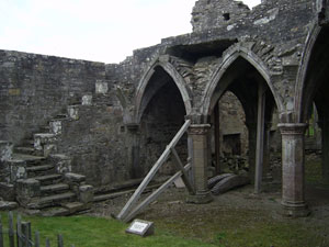
Collessie
 |
| Lindores abbey |
Several charters of Lindores
Abbey refer to a right of way between the abbey and
a petary in present day Collessie parish. The charters
were translated by John Dowden, Bishop of Edinburgh,
in his edition of the Chartulary, published in 1903.
Extracts from these are given below.
A charter of Roger De Quency (charter 135, page 176)
says that:
| |
"the
monks of Lundors, and their men with their oxen,
horses, and carts should have a free road (cheminagium)
through the middle of his wood of Kyndeloch, if
they think it an advantage to them, and through
the whole of his land, wherever it might seem to
them best and most suitable, as far as to the moor
of Edyn for heather; and through the middle of the
moor itself as far as the peatmoss, which is called
Monagrey, for peats, and thence to the monastery,
both going and returning, without hindrance or opposition
from his bailiff, or the bailiff or his heirs and
successors."
Dowden notes that "cheminagium (chymnachium)
is from the old French cheminage, commonly used
for the payment of tolls demanded by the owners
of forest for the passage of horses and wagons.
Liberum cheminagium is permission of passing without
toll through the wood." |
A charter of Elena of Brechin
(charter 136, page 177) gave Lindores two small parcels
of land in Kyndeloch where they could stack their peat.
The charter says of these lands that:
| |
"one is
called Inch (Insula), which lies to the north, immediately
next to the land which the monks have and had in
the vill of Kyndeloch. And that Inch is surrounded
on the west and north by a marsh, which is called
in English Seggymir, and on the east by a marsh
which is called in English Muchelli. But the other
small portion is in the south part of the moor of
Edin lying, on its north part, next adjoining the
marsh of the monks, which by another name is called
Mungrey. And that small portion of land contains
one acre and a quarter. She also gave the monks
"a free road for drawing and carting (cariandi)
the said fuel without hindrance through her lands
of Kyndeloch from their marsh to each of the two
places, and beyond, as often as they please and
have need." Dated August 1302 |
Charter 137 (page 180) of Roger de Quency granted Lindores
200 cart-loads of heather each year from his moor of Kyndeloch
and the same amount of peats from his peat-moss of Monegre.
He also granted one acre nearby where they could dry the
peats and:
| |
"a
messuage adjacent to the nearest ford, which is
called Ethyweyn, on the eastern side in the field
(in campo) of Thoreston, containing two acres of
land, to which messuage they can draw their heather
and peats. Further, the monks and their men are
permitted to have a free road (chiminagium), in
a straight line as far as the moor, for heather,
and a free road through the middle of the moor for
peats, and thence to the messuage in returning."
Dated 1247.
A messuage implies a dwelling with outbuildings. |
John de Kocbrun (Charter 140, page 186) gave Lindores:
| |
'that
whole land with its pertinents which lies in breadth
between the main road (magnam viam), which leads
from my vill of Cullessin to the monastery of Lundors,
and the land of the monks which is called Cardynside,
and in length, beginning from the land of the same
monks which is called Suthleys, towards the north
as far as the burn (rivulum) running into the great
lake, between me and them, with that small portion
(particula) of land which I have caused to be estimated
(extendi), and bounded for them on the south part
of the aforesaid main road, in a right line from
my land which is called Wudeknocside northward as
far as the middle of the meadow belonging to the
same monks, which is called the meadow of the great
lake.
Moreover, he gives to the monks two acres of land
outside the vill of Culessin, towards the north,
where they may make a messuage for themselves, to
which they can draw their peats and other goods,
and there, if they wish, keep them safe ; and also
a free passage or road by the midst of his land
of Coulessin, to wit, in going through the midst
of his vill of Coulessin, with their men, horses,
oxen, waggons, and carts (carrectis), towards their
peat-moss in the moor of Edyne, and in returning,
by the same way, as they had been accustomed for
the purpose of drawing their fuel, without any disturbance
on the part of him, his heirs, and assignees, excepting
[damage to] their corn and meadow-grass (herbagio)."
Dowden identifies the great loch as the loch of
Rossie which was drained in the late 1700�s. He
acknowledges an alternative view that it could be
the loch of Lindores. |
Interpretation
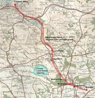 |
Click on map for larger image.
Based on the 1926 one-inch map for Dundee
& St Andrews. With thanks to Ordnance Survey. |
Unfortunately, not all of the placenames have survived
but Monagre is shown on the Military Survey map just
east of Ladybank. Kindeloch is Kinloch south of Collessie
and the name Moor of Eden still survives. The location
of the small parcels of land where the monks could collect
their peats and heather is not certain but Monkstown
and Heatherinch (formerly Nether Inch) are possibilities
and there seems to have been grants of land nearer to
Kinloch and to the north of Collessie.
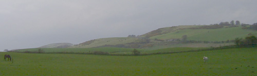 |
| The track is likely
to have run over these hills to Lindores |
The last charter is difficult to interpret although
the reference to the magnam viam between Collessie and
Lindores abbey is clear enough. The topography suggests
it would have had much the same route as today, probably
on a higher line as this would be drier - Silver (Roads
of Fife) suggests it could be the track running up through
Braeside and to the east of Green Law.
Although it cannot be determined exactly today, the
route taken by the right of way through Collessie and
Kinloch to Monagre must have been fairly direct, perhaps
through Monkstown.
Collessie
Of the Manse near the Church of Cullessy
Chartulary
of Lindores, charter XCI, page 98
This refers to the public street beside the church of
Collessie.
Newburgh
Sasine of Land in Newburgh
Chartulary
of Lindores, charter CLIII, page 225. Dated 1479.
Notes, page 282
This refers to a sale of land and a house in Newburgh
where in completing the transaction the parties went by
the "straight road" to the location.
Interpretation
It is not clear if this means "going directly to"
or is an actual reference to a straight road. As it
was in Newburgh we would in any case expect there to
be streets
Newtyle
William Wascelyn's Charter of the Land of Newtyle
Chartulary of Lindores, charter XXXVII, page 39. Notes,
page 247. Date: c.1200
This is dealt with under Angus.
It refers to some land in Newtyle between the high way
and the hill (or perhaps the upper road and the hill).
Insch
Of the Chapel of Weredors
Chartulary of Lindores, charter LIX, page 65. Notes,
page 254. Dated 1228X1239.
This is dealt with under Aberdeenshire.
It refers to land near Wardhouse, west of Insch, lying
"between the great road and the moor towards Gillandreston".
This may have been a long distance route between Inverurie
and Huntly and beyond.
Kinnemonth
Church Land of Rathmuriel
Chartulary of Lindores, charter LV, page 61 Dated
1245
This is dealt with under Aberdeenshire.
It refers to a high road which goes from the ford of Ury
towards Leslie.
Inverurie -
Bridge of Balhaggardy (Balhalgardy)
Charter of Earl John concerning xx. shillings in Inverurie
Chartulary of Lindores, charter XVII, page
21. Date 1232X1237. Notes, page 240.
This is dealt with under Aberdeenshire.
It mentions the Bridge of Balhagerdyn, about two miles
north of Inverurie.
Inchcolm
Abbey
Overview
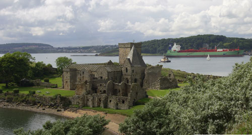 |
| Inchcolm Abbey. |
In 1123, Alexander I was driven to Inchcolm island
during a storm, and vowed to build a monastery in thanks
for his deliverance. However he died before he was able
to keep his promise.
Shortly after, his brother, David I, invited a party
of Augustinian canons to set up a priory on the island.
It was eventually made an abbey in 1235.
Like other abbeys it received generous grants and a
few roads are referred to in its charters. In the north
of Dalgety parish, near Fordell, a couple of roads or
tracks are referred to but are difficult to identify.
There is however a clear reference to a road coming
from Dunfermline and a mention of an ancient bridge
near Fordell. In Aberdour there is mention of a road
to Kinghorn, and a road at the west of the town which
probably came from Queensferry and Inverkeithing. This
would give a continuous route from the ferry to Kinghorn,
something we would suspect anyway from the death of
Alexander III. A charter for Leith mentions the high
road between Edinburgh and Leith, and one for Tibbermore
in Perthshire ties in well with one for Scone abbey
and is likely to be the "Old Gallows Road".
• Charters
of the Abbey of Inchcolm, D.E.Easson & Angus MacDonald
(Eds), Scottish History Society, 1938
•
The Roads of Fife, Owen Silver, John Donald Publishers
Ltd, Edinburgh 1987
• William
Ross, Aberdour and Inchcolme, 1885
• Further
details of charters pre-1314 can be found on the People
of Medieval Scotland website, see Inchcolm
charters. Amanda Beam, John Bradley,
Dauvit Broun, John Reuben Davies, Matthew Hammond, Michele
Pasin (with others), The People of Medieval Scotland,
1093�1314 (Glasgow and London, 2012) www.poms.ac.uk.
Dalgety - marches
of the moor of Boclavy and of Fordell
Charters of the Abbey of Inchcolm. Charter XIX,
page 17. Notes p.130. Date: 1240
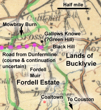 |
| Fordell and Bucklyvie
boundaries in green. These also follow parish boundaries.
Based on 1913 OS half-inch map, with thanks. |
This relates to a dispute between Inchcolm and William
de Hercht, lord of Fordell, over the marches of the
moor of Bucklyvie and Fordell. The marches are given
thus: "Beginning at the ford called Hollefurd and
ascending by that syke (a small stream, often dry in
summer) which goes from the west side of Glasgely as
far as the cross next to the bridge of the canons which
leads to the canon's petary of Glasgely. And from that
cross as far as the high road (altam stratam) and by
that high road as far as the syke which goes round the
Grenhill. And from the foot of Grenhill as far as the
foot of Blakhill, as a pile of stones placed there shows,
as far as an ancient bridge which is between the spring
and the petary of which a certain part was in contention.
And from the bridge by a path at the head of the spring
that leads to the side road directly towards the south
as far as a cross which stands above the mother syke.
And from that cross as that mother syke falls in to
Rereford.
And know that the abbot and convent and their men shall
have free passage from that cross that stands above
the mother syke transversly to the high road that comes
from Dunfermline (altam stratam que ducit de Dunfermling)
for carts and wagons and their cattle freely and without
impediment saving damage to the crops of the said William.
Also by the rivulet which falls from Rerefurd as far
as opposite Hakenheuid and from there as far as a pile
of stones, called a cairn, towards the west. And from
that cairn towards the south by piles of stones as far
as a great round stone. And from that stone by piles
of stones as far as that syke which falls into the petary
of Coleistoun."
Interpretation
With most of the placenames lost and doubt about those
remaining, this is nearly impossible to interpret. Some
help in identifying the approximate location (other
than Wester Bucklyvie and Fordell) is provided by two
documents. One is a 6-inch map (sheet
XXXIX NE) which has been marked to show farm boundaries,
the other is a plan
of Fordell estate made in 1756.
The estate plan shows that the boundary between Bucklyie
and Fordell ran north-south between them and followed
the parish boundary. Although this was in 1756, land
boundaries do survive for long periods of time and there
seems little to doubt that this is the case here. To
the north, the estate plan shows Fordell turning west
along a parish boundary at the Mowbray Burn.
From this, two possibilities for the location of Bucklyvie
Moor suggest themselves: one is north of the village
of Fordell, the other just south of Fordell where Fordell
Muir was, on the assumption (which may be incorrect)
that Bucklyvie Muir would adjoin it.
The estate plan shows numerous boundary stones and
it is likely that these are the same as those mentioned
in the charter, though exactly where they coincide is
difficult to say. One slight clue to the location is
the Blakhill which may be the same as the Blackhill
in Fordell itself; the only other hill nearby is Gallows
Knowe which may be Grenhill. If this was the case then
the starting point of the charter may have been up at
the Mowbray Burn, then following a stream up to Gallows
Knowe and the road. This would suggest the road ran
east to Kirkcaldy. This however is conjectural.
From the Blackhill it may be describing the marches
to the south. William Ross's (Aberdour and Inchcolme,
p. 85) identifies Coleiston as Couston, about one mile
west of Aberdour; the abbey had lands in this area.
Another possibility is that it is the Coaltown shown
on the estate plan. If Ross is correct it suggests the
charter is describing the boundary all along its length.
With such slight clues, it is hard to say much sensible
about the roads other than repeating the charter itself,
viz. that a road ran in from Dunfermline to the Fordell
area and that the abbey had a right of passage cutting
across from this to their own lands and that there were
a couple of local tracks. The mention of the ancient
bridge is intriguing but its location is uncertain.
•
William Ross, Aberdour and Inchcolme, 1885
• People of Medieval Scotland
website. Document
4/20/31.
Aberdour
Registrum
Honoris de Morton, vol.2. Charter 231, page 236. Dated
1474.
This was a grant by James, Earl of Morton, to the Vicar
of Aberdour of one acre of land lying within the territory
of his town of Aberdour, at the east end of it, and on
the north side of the road which leads to the town of
Kingorne (Kinghorn). This was to be used for a hospital
which could also be used by pilgrims visiting the pilgrim's
well in the town.
The original grant of one acre was augmented by further
grants, viz. Reg. Hon. de Morton, Charter 232, page 238;
Charter 233, page 240.
For translation see Aberdour
and Inchcolm, William Ross, 1885 Lecture 3, page 46.
On page 48 he refers to arrangements to ensure that a
road, "not less than 16 ells in breadth", would
extend to "le pylgramys well."
Charters of the Abbey of Inchcolm. Charter LXVII, page
93. Dated 1548. Notes page 208
This document refers to land on the west side of Aberdour
close by the king's highway (via regia). It is likely
that this led to Inverkeithing and Queensferry.
Leith
Charters of the Abbey of Inchcolm. Charter XIII, page
11. Notes page 118. Dated c.1220-1226
This charter is dealt with under Mid-Lothian.
It refers to land "in the territory of Restalrig
on the west side of Horstanes and on the south side of
the high road between Edinburgh and Leith (alte strate
inter Edinburgh et Leth)". The road ran by the later
Bonnington Road and Broughton Road to Holyrood Abbey.
Tibbermore
Charters of the Abbey of Inchcolm. Charter XXXVII, page
36. Notes page 154
This is dealt with under Perthshire
(Scone Abbey) and is for a grant of land near Tibbermore
which mentions a road to the south of the settlement.
It is possible that it is the continuation of a road mentioned
in a Scone charter, also for Tibbermore.
Dunfermline
Abbey
Overview
In 1070, a priory was founded in Dunfermline by Queen
Margaret, wife of Malcolm Canmore and settled by Benedictine
monks she invited from Canterbury - there was an earlier
Culdee establishment in Dunfermline. In 1128, her son
David I elevated the priory to an abbey in honour of
his mother, building a new church and providing the
new abbey with many generous gifts. In time, Dunfermline
became one of the weathiest abbeys in Scotland.
There are numerous references to roads in the charters.
Some are just tracks that gave access to parts of an
estate but others gave access to nearby settlements
where the abbey had lands. In a couple of cases there
are useful references to long-distance routes leading
to Perth and St Andrews.
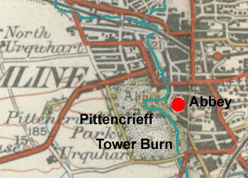
In Dunfermline itself, other than streets there was
a reference to a bridge over the Tower Burn to Pittencrieff.
Immediately south of Dunfermline they had a port at
Limekilns with valuable shipping rights, and a road
must be presumed to have run from here to the town and
to a grange just south of Dunfermline. Nearby, at Pitfirrane,
there were "gates" giving access to parts
of a runrig system. Although not mentioned below, there
is a tradition that Margaret and her party made landfall
at a bay now called St Margaret's Hope and on the way
to Dunfermline Margaret stopped to rest at a stone called
St Margaret's Stone. A road does pass this stone and
as it leads directly to the town it is likely enough
that there was an early road on this line.
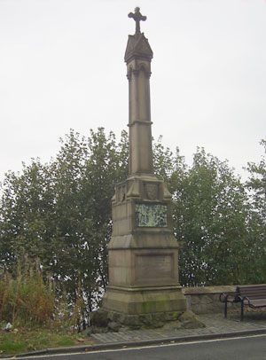 |
| Memorial to Alexander III, killed
by a fall from his horse near this spot. |
At Dunduff, a few miles north of the town, there is
mention of a ford, a word that sometimes has the meaning
of a "way" as well as the usual meaning of
a crossing point on a stream. Whatever the case, any
related track is likely to be local. Although not mentioned
specifically in the charters, it is very likely that
there was a coastal route from the ferry over the Forth,
through Inverkeithing to Kinghorn and Kirkcaldy. Alexander
III was killed in 1286 near Kinghorn as he was making
his way at night and in bad weather to see his new bride
in the castle at Kinghorn.
Three charters allow us to reconstruct north-south
routes through Fife. One charter refers to a road leading
directly north from Inverkeithing to Perth and another
charter has a road from Dunfermline to Perth joining
this near Kelty. The third charter picks up the road
again at Kinross - the via regia being described as
ancient.
At Markinch there was an ancient bridge but it is not
certain if it was on a local or long distance route.
Over at Largo Law, there is mention of a couple of tracks,
probably local, a bridge, and a road to St Andrews that
is likely to have had the line of the present day A915
road.
Outwith Fifeshire there was a controversy with Coupar
Angus over access to the lands of Bendochty just north
of Coupar Angus abbey, and another argument with the
convent at North Berwick which has a useful reference
to a causeway running north from the earlier bridge
at Stirling to Airthrey. Also at Stirling was an exchange
of land that refers to the via regia leading to Cuiltedouenald,
perhaps in St Ninians south of the town.
At Airntully in Perthshire there is mention of local
access to moorland, and near Edinburgh there is mention
of a road near Colinton that is likely to be the road
to Lanark. At Musselburgh there was a road to Niddrie,
three miles to the west; and a couple of short routes
near Inveresk and Dalkeith as well as one from Haddington
to Newbattle.
Also of note are the numerous references to Queensferry
that gave important access to routes to Perth and St
Andrews.
The maps below are based on the 1913
OS half-inch map, sheets 23 and 27. With thanks to Ordnance
Survey.
• Registrum
de Dunfermelyn, Bannatyne Club, 1842
• Royal
Dunfermline - see Resources
•
The Roads of Fife, Owen Silver, John Donald Publishers
Ltd, Edinburgh 1987
•
The Internet Archive has various works
on the history of Dunfermline and the abbey, see here.
• Further details
of charters pre-1314 can be found on the People of Medieval
Scotland website, see Dunfermline
charters. Amanda Beam, John Bradley,
Dauvit Broun, John Reuben Davies, Matthew Hammond, Michele
Pasin (with others), The People of Medieval Scotland,
1093�1314 (Glasgow and London, 2012) www.poms.ac.uk.
Dunfermline
Register of Dunfermline: Charter 443, page 335
 |
| Based on the 1927 one-inch map
for Stirling & Dunfermline. With thanks to Ordnance
Survey. |
This charter refers to a street in Dunfermline leading
from a town port towards the Tower Burn: "viz.
near our lower port situated in the lower part of the
burgh of Dunfermline in the street which extends from
the said port to the water of Ferm, colloquially called
the Tower Burn on the west side of the same street between
the garden of the blessed Laurence on the north side
on the one hand and the said water on the south side
on the other along with a portion of land lying on the
west side of the same garden…"
Viz. propre portam nostram inferiorem
iacente in villa inferiore burgi de Dunfermeline in
vico que extendens a dicta porta ad aquam de ferm wlgariter
nuncupatum tourburne ex parte occidentali eiusdem vici
inter ortum beati laurencij ex parte boreali ex parte
vna 7 dictam aquam ex parte australi ex altera vna cum
particata terre que iacet ex parte occidentali eiusdem
orti……
-----------------------------------------------------------
Register of Dunfermline: Charter 370, page 253
This mentions a bridge called the Girth Bow. Sheila
Pitcairn in A
History of Pittencrieff Glen/Park 9.6Mb (page 5)
places it near to St Catherine’s Yard or Garden
and suggests it connected the abbey with the royal burgh
on the other side of the Tower Burn (see also p.16 for
a reference from Mackie in The “Journal” Guide
to Dunfermline who says that the Gyrthbow was probably
the original crossing made by the Abbots and Monks as
they passed between the Monastery and the pleasant fields
and gardens of Pitencrieff. It would have been replaced
by later bridges, one of which was the “Double
Arched Bridge.”)
---------------------------------------------
Carta de communia Ville de Dunfermlin
Register of Dunfermline: Charter 596, page 415.
This charter refers to the via regia to Perth, north-east
of the town of Dunfermline. A translation is given in
A
history of the town and parish of Dunfermline, John
Fernie, page 193ff, as follows:
"Be it known to you that we after serious and attentive
deliberation in our chapter on what regards the interest
of our monastery have given granted and by this present
charter confirmed to the community of our borough of
Dunfermylyne and the burgesses thereof as a common that
part of our moor extending in length from the boundaries
of Waltirselis to the straight marches of Beedgall reserving
to ourselves our peatmoss of Beedgall and from the high
way to Perth and the boundaries of Greenauch to the
straight marches of Tulch in breadth together with the
peat moss in said moor And likewise that piece of land
extending from the high way to Perth to Moncor bank
and situate within the two ditches (duo sycheta) running
in a line from Moncor till they reach the high way to
Perth the said piece of land being of equal breadth
with that of Moncor opposite thereto."
The same boundaries are given in a confirmation charter
of James VI in 1588 (see Burgh
Records of Dunfermline, xlviii).
Interpretation
 The
area in question lies about one to one and a half miles
to the north-east of the town centre, around the Townhill
area. Fernie's rendering of the placenames varies slightly
from the Register, particularly his Greenauch which
is Creuoyn in the Register. It has survived in Garvock
Hill. Tulch is Touch and Townhill was formerly known
as Moncur. Beedgall and Waltirselis are lost though
in the same general area. It is likely that Moncur bank
(ripam de moncor) is a reference to the shores of Moncur
Loch (Town Loch). The
area in question lies about one to one and a half miles
to the north-east of the town centre, around the Townhill
area. Fernie's rendering of the placenames varies slightly
from the Register, particularly his Greenauch which
is Creuoyn in the Register. It has survived in Garvock
Hill. Tulch is Touch and Townhill was formerly known
as Moncur. Beedgall and Waltirselis are lost though
in the same general area. It is likely that Moncur bank
(ripam de moncor) is a reference to the shores of Moncur
Loch (Town Loch).
Despite these clues it is hard to place the boundaries
of the Common. However, the course of the Perth road
is known from later maps such as Adair (1775) and the
charter references confirm that it had the same course
in the middle ages.
Inverkeithing
Quedam perambulacio in abbatem R 7 convent de Dunfermlin
7 G de mubray de quedam particula terre apud Inverkethin
Register of Dunfermline: Charter 592, page 411
 This
was a perambulation between Dunfermline and G de Mubray
on a certain plot of land near Inverkeithing. It reads: This
was a perambulation between Dunfermline and G de Mubray
on a certain plot of land near Inverkeithing. It reads:
"Towards the east as it extends northwards next to
the well called Kellohouis Well on its eastern side and
so towards the north side as far as plukylaw on the east
side and so by a path with stones placed between and below
white meadows towards the south keeping close to the foot
of the said white meadows as far as a green road towards
the eastern part that the road goes towards the north
next to the well called the Hasocwel on the east side
and so as far as the black hill on the west side of Carnihole
according to the stones fixed there and signed with a
cross and so to the sike of the marsh called the Croslech
next to the marsh called the Crosmire which exits towards
the west and so eastwards of Threpeland and the said marsh
as stones signed with a cross have been fixed there, and
so north to the Croslech next to the said marsh And so
to the marsh called the lord’s marsh towards the
east and so from the eastern side of the lord’s marsh
to the via regia which extends from the town of Perth
to Inverkeithing, and it is understood that the dry and
arid lands as far as the sike called the Croslech will
remain with the abbot and convent of Dunfermline and the
land of the marsh with the lord G de mubray.."
….versus orientem que se extendit versus boriam iuxta
fontem qui vocatur Kellohouis Well proxime ex parte orientali
7 ita versus partem borialem vsque plukylaw ex parte orientali
7 sic per semitam lapidibus interfixam subtus album pratres
versus austrum proxime adherente ad pedem dicti albi patres
vsque ad viridem viam versus orientalem partem que via
se extendit versus boriam iuxta fontem que vocatur le
Hasocwel ex parte orientali 7 sic usque ad collem nigrum
ex parte occidentali de Carnihole secundum que lapides
ibi fixi sunt 7 crucesignati 7 sic usque ad sicchetum
marisium que vocatur le Croslech iuxta marisium qui vocatur
le Crosmire exiens versus occidentem 7 sic versus orientem
del threpeland 7 dictum marisium secundum que petras ibi
fixe sunt crucesignate 7 sic versus boriam usque Croslech
iuxta dictum marisium 7 sic ad marisium que vocatur marisius
domini versus oriente 7 sic vsque ad viam regiam ex orientali
parte marisium domini que se extendit de villa de perth
versus Inverkethyn 7 est sciendum que terra sicca 7 arida
vsque ad scichetum que vocatur le Croslech remanebit abbati
7 conuentui de Dunfermlin 7 terra marisio remanebit domino
G de mubray
Interpretation
All the placenames have disappeared. However, given
the directness of the line, the placename Crossgates,
and the orientation of the main street in Inverkeithing
it is very likely that the via regia from Perth to Inverkeithing
is identical to or close to the pre-turnpike road that
runs parallel to the B981 - see map by Sharp,
Greenwood and Fowler 1828). The B981 was the old
turnpike, marked on early OS maps as the Great North
Road. The road in question here was joined at Kelty
by the medieval road from Dunfermline and continued
to Kinross.
Gellat
Carta Dauid Regis de portu de Gellald
Charter of King David of the port of Gellald
Register of Dunfermline: Charter 391, page 270. Dated
1364
In this charter of David II, the abbey was given the
right of a port on the shores of the Forth, south of
Dunfermline. Henderson, in his Annals of Dunfermline
provides a translation as follows:
"David, by the Grace of God, King of Scots,
to the whole upright men in the
kingdom, Greeting, - Know ye that I have given and granted
to God and the
the blessed Margaret the Queen, to the Abbot and Monks
of Dunfermlyn
serving God there, and to serve God there forever, for
themselves, their
burgesses, and merchants, that they hold a port or harbour
at Grange, of
Gellald, or at Wester Rossyth, with the consent of the
owners thereof, for
all sorts of goods and merchandise, as well as wool,
hides, and skins; and
at the said harbour by the merchants of the same, for
carrying, importing,
exporting, and weighing, freely, lawfully, as they may
see most expedient
for themselves - reserving to ourselves always the Great
Customs," &c."
From Annals
of Dunfermline, Henderson, page 139
 Interpretation Interpretation
It is not quite clear where the Grange of Gellald
was. There is a "Grange" and "Grange
Mount" just south of the town (NT0985), and there
are Gellald (now Gellat) placenames about a kilometre
or so to the south again. This does not matter too much
as there is general agreement among those who have written
about Dunfermline that the port would have been somewhere
near Limekilns, perhaps Bruce Haven. A road would have
run from the shore to the grange and presumably the
abbey and town to carry all the merchandise mentioned
in the charter. Ainslie's
map of 1775 shows a road close to this line, passing
Wester Gellat and Grange, which may be the road presumed
to have existed in the middle ages.
Peter Chalmers in his History of Dunfermline has interesting
comments about Gellald, viz:
"There is frequent mention made in the Register
of the Schire of Gellald or Gelland, as at pp 3, 5 &c.,
the gift of King Edgar, and of the Port at the Grange
thereof, or at Wester Rosyth, (Register p 270), the
gift of King David II. It is not improbable that the
district, so named, may have been the southern part
of the parish of Dunfermline, where were the two properties
of East and West Gellet, and where is the harbour now
named Brucehaven, near the Old Church, at the west end
of the ancient parish of Rosyth. It is mentioned, too,
as adjoining to Pitliver, in the south east part of
the parish, and separated by a stream from the land
of Abercromby (Register p 125). It may even have extended
to the eastern part of Torryburn Parish, where there
was a farm, and still is a toll, named Gellanderston."
Peter Chalmers, History of Dunfermline, Vol.1, page
209.
Pitfirrane
Contractas inter abbatem et conuentum monasterii de
Dunfermlyn et dauid Haket de perambulacione terrarum de
petfurane
Contract between the abbot and convent of the monastery
of Dunfermline and David Haket on the perambulation of
the lands of Petfurane
Register of Dunfermline: Charter 486, page 285. Dated
1437
 This
charter refers to an adjustment between the two parties
of the lands owned by each in the Petfurane area. It
refers to “gates” in a couple of places and
from the context these seem to have been strips of land
giving access to different parts of a runrig system. This
charter refers to an adjustment between the two parties
of the lands owned by each in the Petfurane area. It
refers to “gates” in a couple of places and
from the context these seem to have been strips of land
giving access to different parts of a runrig system.
The references are:
We haue deliviret to ye said Abbot and convent als
mekil land liand on the south hauf yer oxgang safand
a gate liang betuix of fourty fute brede ye qwhilk land
to yam deliverit is of quantite tua acris thre rude
and fyften fall in ye hale. Alsua we decret and ordainis
yt ye gate liand betuix ye said Dauidis orchard and
his westir oxgang extendand fra ye chemy of the said
Abbot and convent to ye gate liand be north ye herber
hill be comon to baith ye partes, and yat it be threttie
fut brad sanfand ye yhate betuix ye bern and ye biir
of ye said Dauid ye qwhilk sa remain of ye samyn quantitie
yat it is now of ye qwhilk threttie fute yar sel be
ten fute of ye rynryg of ye Abbot and ye convent, and
twentie fute of ye rynrig of ye said Dauid fd. it pas
ye bern and ye biir northwards to ye gate extendand
to ye herber hill.
These refer to:
1) On the south side of the abbey’s oxgang, a gate
forty feet wide, between it and a parcel of land in
the transaction;
2) The gate lying between the said David’s orchard
and his wester oxgang should now extend from the abbey’s
main dwelling to the gate lying north of herber hill.
Between this dwelling and David’s barn and byre
it was to be held in common and be 30 feet broad. From
the barn and byre to the hill it was also to be 30 foot
broad, 10 foot of which was to belong to the abbey's
runrig and 20 foot to David's runrig.
For original text see here
Also Annals
of Dunfermline, Ebenezer Henderson, 1879, p. 152/3
Dunduff
Perambulacio inter terras abbatis de Dunfermelyn 7
terram Dauid hostiarij scilicet Dunduf
Perambulation between the lands of the abbot of Dunfermeline
and the lands of David the Doorward, namely Dunduf
Register of Dunfermline: Charter 196, page 111. Dated
1231
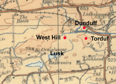
...beginning at the same divisions from the east of
the hill called Torduff and descending from that summit
northwards to a syke and so westwards as far as a marsh
and so by a valley to a certain ford thence to the east
of Cragfode and so by the middle of the marsh towards
the south as far as the bounds of Lusk Gocelin...
..incipientes easdem
diuisas ab oriente montis qui dicitur torduf descendendo
per sumitatem illius versus aquilonem ïn siketum
7 sic versus occidentem usque ad marisium 7 sic per
uallem ad quoddam uadum 7 inde ad orientalem de cragfode
7 sic per medium marisij versus australis usque ad diuisas
de lusk Gocelin..
Interpretation
It can be seen from the map that there is a fairly
close fit with the charter. Torduff is probably the
hill to the south of Dunduff with a stream to the north
of it. Cragfode is likely to be West Hill with the ford
somewhere in the vicinity. Ford can sometimes mean "way"
but whichever meaning is intended, a path is entailed.
The 6" map (Fifeshire
Sheet 35) shows some footpaths in the area, one
of which runs north south by West Hill, and which would
fit the wording quite well.
Kinross
Adthangy
Register of Dunfermline: Charter 232, page 148/149. Dated
1319
This charter refers to a via regia near Kinross which
from the context is likely to be the road to Perth. An
old bridge is also mentioned.
The extract reads:
From the southern part of the Hill of Ardeno as an old
bridge was at one time (where there used to be) and
so ascending by a marsh towards the north and west by
a syke which extends alongside Le Aly from the south
side of Inchehoche and so from that syke which is called
Ury and as an old course of that syke runs below le
Aly and so ascending to an ancient via regia and by
this northwards towards the water of Northchuy (North
Quiech) and so by the ancient course of the previously
mentioned water descending towards the east as is made
plain by bounds made by the foresaid perambulators as
far as the aforementioned Loch Leven. Also they said
likewise that the land of Autangy would have common
pasture in the moor of Mauchchuy (Mawhill) and entry
and exit to the said pasture, namely a loaning by the
north side of the Aly…
.....ab australi parte montis de Ardeno
sicut vnus vetus pons fuit quondam 7 sicut ascendendo
per vnum maristum versus boream 7 occidentem per vnum
Sychetum se extendentem apud Le Aly ex parte australi
de Inchehoche 7 sic ab illo sycheto que vocatur Vry
et sicut antiquus cursus illius Syncheti currebat infra
le Aly 7 sic ascendendo ad antiquam viam Regiam 7 sic
per viam Regiam versus aquilonem usque ad aquam de Northchuy
7 sic per antiquus cursus aquae prenotiate descendendo
versus orientem sicut patet per metas factas per perambulatores
prescriptos vsque in lacum de Leuyn ante dictum. Item
idem dixerunt que terra de Autangy heret communam pasture
in mora de mauchchuy 7 ad dictam pasturam exitum 7 introitum
scilicet Lonyng per latus aquilonale de le Aly......
Interpretation

Adthangy is very likely to be present day Lethangie
which lies between Kinross and Milnathort. It fits the
wording of the charter and on one early map (Gordon,
Kinross-shire) is named Lathangie. A map on Scotland
Places shows the modern boundary of Lethangie
farm.
Only the North Quiech and the Ury Burn can be identified
with any certainty. However, working backwards from
the end of the charter, one would follow the North Quiech
upstream to reach the via regia and then follow this
southwards to another burn though it is hard to tell
if it is the Ury or the Aly. Beyond this point, the
charter is unclear. Despite this, it is likely enough
that the via regia ran through the town of Kinross and
followed the line of the present road which ultimately
leads to Perth (a Melrose charter mentions that Robert
I (Liber
Melros, V.2, p.358) gave them a toft in Kinross
on the side of the main road leading to Perth). It is
not clear where the old bridge was and if it was associated
with the via regia.
Mauchchuy is very likely to be Mawhill (cf. Barrow,
Scotland & Its Neighbours p.106). As the charter
says that the loaning was on the north side of the Aly
it could be that the Aly is what is now known as the
Ury Burn, or part of it, as this would give a direct
route towards Mawhill, .
Markinch (Goatmilk
and Auchmuty)
Littera perambulacionis terrarum de Gaytmilk schire
de Admulty
Register of Dunfermline: Charter 458, page 355. Dated
1466
This record of the perambulation of the bounds between
Gaitmilk and Admulty mentions an ancient bridge over
the Leven:
"..viz, beginning at the east side of the lands
of Admulty towards the south at the place colloquially
called Gochry Den, and so ascending as stones are sited
and located near the arable lands and ditches of Admulty
as far as three large stones located by the marches
of the same lands in the west. And from there heading
north and descending as stones are placed with ditches
as far as the end and place of an ancient bridge over
the water of Leven and as far as the middle of the same
water…"
….Viz. jncipiendo ad orientalem
partem terrarum de Admulty versus austrum ad locum wlgariter
dictum le gochry den Et sic ascendendo sicut lapides
sunt sitj et locatj propre terram arabilem et foueas
de Admulty vsque ad tres magnos lapides locatos per
marchia earundem terrarum in occidens Et de hinc vergendo
versus boream et descendendo sicut lapides siti cum
fouea vsque ad finem et locum antiquj pontis super aquam
de levin et vsque ad medietatem eiusdem aque...
Interpretation
 |
| The new town of Glenrothes covers
most of the area of this map. The town centre is
just north of Auchmuty. Parish boundaries in green;
farm boundary purple. |
Goatmilk is south of Leslie and sw of Glenrothes. Admulty,
now Auchmuty, is Gaelic for “ford of the wedders”
and lies to the east of this. Using the parish boundary
and the boundary of Auchmuty farm (6"
map marked to show farm boundaries - Fife XXVII NE
-ScotlandsPlaces website) there is quite a strong possibility
that the perambulation started east of Auchmuty then
went south to reach both boundaries. Following these
to the west it is then said to have turned north to
run to the Leven, just as the two boundaries do. The
placename Gochrie Den has disappeared, as have the stones.
Given that the charter dates from 1466, the "ancient
bridge" may date from the early middle ages, 300
or so years before rather than an earlier period - bridges
can decay quite considerably over 300 years and so appear
"ancient". It is not at all clear what route
it might have been on. The nearby Cow Bridge is much
later.
Largo area
Overview and interpretation
The following charters for the Largo area refer
to some roads, including a road to St Andrews, and a
bridge. While the charters have elements in common,
they are nevertheless very difficult to interpret. The
easiest approach is probably to use the parish boundary
as shown on the map where lands to the west and north
of this would be the Earl of Fife's (Largo parish) and
lands to the east (Newburn parish) would belong to Dunfermline,
with the assumption that the charters would refer to
this, or sections of it.
 With
the first document, the road from Nythbren (Newburn)
to Balmani (Balmain) is likely to have taken a fairly
direct route over the north side of Largo Law. The Peth
could indicate a water-course or steep path up a hill
- see DSL,
or possibly be the Pictish pit indicating a portion
or piece of land. The location of the Queen's Bridge
is hard to tell from the wording although one would
expect it to be on the St Andrews road. With
the first document, the road from Nythbren (Newburn)
to Balmani (Balmain) is likely to have taken a fairly
direct route over the north side of Largo Law. The Peth
could indicate a water-course or steep path up a hill
- see DSL,
or possibly be the Pictish pit indicating a portion
or piece of land. The location of the Queen's Bridge
is hard to tell from the wording although one would
expect it to be on the St Andrews road.
The second document has a road from the smithy of Nythbren
to Balbard. This is likely to have been very direct,
and probably sharing part of its course with the Balmain
road.
The third document mentions the Nythbren to Balmani
road.
As to the final document and the reference to the road
to St Andrews, the directness of the line suggests the
same or similar line shown by the present day A915 from
the coast at Largo to St Andrews.
-------------------------------------
Mete de Melgum
Register of Dunfermline: Charter 334, page 223,
Evidence of the Abbot of Dunfermline on the bounds and
divisions of the mount of Melgum. This says: "Beginning
near the Peth (see above note) of the same hill and
so descending by a road that comes from the smithy of
Nythbren and goes towards Balmani as far as the head
of a certain well and so descending by the stream that
comes from the same well as far as the Queen’s
bridge and so eastwards by a certain syke from the foresaid
bridge as far as a stone situated in the northern part
of Melgom and so by that stone as far as another stone
called the Harstane which lies at the outer boundary
of Balbard and so ascending by the same bounds as a
furrow has been drawn where it is to be ploughed."
Euidencia Abbatis de Dunfermlyn super
metis et diuisis montem de melgum. Incipindo apud le
Pethe eiuisdem montem 7 sic descendendo per via que
venit de fabrica de Nythbren (near Upper Largo) et tendit
versus Balmani (see Register of the Great Seal) vsque
ad capud cuiusdam fontem 7 sic descende deinde per riuulum
eiusdem fontem vsque ad pontem Regine et sic versus
oriente per quedam Sichetum a predicto ponte usque ad
lapidem que iacet in aquilonali parte de melgom 7 sic
de illo lapide usque ad lapidem qui vocatur le Harstane
qui iacet ad finem mete de Balbard 7 sic ascendendo
per eandem metas sicut sulcus aratri se habet in arando
=====================================================================
Carta perambulacionis de melgow
Charter of the Perambulation of Melgow (Melgum)
Register of Dunfermline: Charter 590, Page 409. Dated
1306
This recorded a perambulation of the lands of Melgum
(in Largo parish), held by the Earl of Fife, and those
of Newburn held by Dunfermline. That part which mentions
boundaries reads:
...Which judges said that the ownership of the fields
which are Melgum are the lord and count of Fife’s…..Dunfermline
having a common (for the supply of food) in the said
field below the underwritten bounds….and the religious
men of the abbot and convent of Dunfermline next to
the foot of the southern parts of the said mount of
knock ascending from the said stones to the well called…..to
the stone called crawstane
and so from that stone north as far as….the lands
of merolri and from….towards the north as far as
a certain R….which is called le…to the north
as far as…..from the smithy of Nithbren towards
Balbard by a road……from peth and thence westwards
as far the foresaid fosse of Balbard. And that the lord
Count of Fife….towards Balbard viz. beginning at
the above mentioned…..stones to the foot of the
southern side of the said mountain. And from thence
ascending towards…..as far as Le Craggegys…as
far as the hill called Le Bolhill and hence ascending
by a certain syke to the well called Le Crickwell…..towards
the east by a certain fosse called le Cragmedu as far
as le Northlandis and so by the said…..Northlandis
as far as the stream called Le Corseburne and from there
towards the north as far as a certain….of R……from
there by the arable land of Balbard to the foresaid
fosse of Balbard…….
Qui jurati dicunt que proprietas campi
qui melgum est domini comite de ffyf ….. Dunfermlin
haberunt commune in dicto campo pascendo infra metas
7 diuisas subscriptas…….. et Religiosorum
virorum Abbatis 7 Conuentas de Dunfermlin iacentes ad
pedes partis australis dicti montis de knock assendendo
de dictis lapidibus vsque ad fontem qui vocatur ………ad
lapidem qui vocatur le crawstane 7 sic de illo lapide
versus boream vsque ad …….terras de merolri
7 de….. versus boream vsque ad quandam R…..
que vocatur le ……ad boream vsque ad …….de
fabrica de Nithbren versus Balbard per viam …….de
peth deinde versus occidentem vsque ad fossam predictam
de Balbard. Et que dominus Comes de fif ………versus
Balbard videlicit incipiendo ad superdictos…….
stanes ad pedem australis partis dicti montis. Hinc
inde ascendendo versus….. vsque Le Craggegys…..
vsque ad collis qui vocatur Le Bolhill de hinc ascendendo
per quendam sichetum vsque ad fontem que vocatur Le
Crikwell …..versus orientem per quandam fossam
que vocatur le Cragmedu usque le Northlandis 7 sic per
dictam ………..Northlandis vsque ad Riuulum
que vocatur Le Corsburne deinde versus boream vsque
ad quedam…… del R …..deinde per terram
arabilem de Balbard vsque ad predictam fossam de Balbard
See POMS for full details - Document
4/37/11
=================================================
Mete de Knoklargauch
Boundaries of Knoklargauch
Register of Dunfermline: Charter 335, page 223/224
 |
| Largo Law seen from Leven -
click for larger image |
This charter also mentions the track from Nithbren
to Balmani, viz:
Bounds of the hill of Knoklargauch (Largo Law) between
the count of Fife and the Abbot of Dunfermline beginning
at two stones in the southern part of the said mount
and ascending to the well called Howwell and so northwards
to the stone called Wadestan and so to the place called
Knokmadyr and so descending to the path of Melgom which
leads from the smithy of Nithbren and by that path to
near Balmani
Mete monte de Knoklargauch inter comitem
de fyf et Abbatem de Dunfermlyn incipiunt ad duos lapides
in australi parte montem predicti ascendendo ad fontem
qui vocatur howwell et sic uersus boream vsque ad lapidem
qui vocatur Wadestan et sic ad locum que vocatur Knokmadyr
et sic descendendo ad semitam de melgom que semita tendens
de fabrica de Nithbren tendit se et per illam itur apud
Balmani
===================================================
De Balbard
Register of Dunfermline: Charter 314, Page 213.
In this charter dealing with the lands of Balbard,
there is a mention of a road to St Andrews.
Thirteen acres adjacent to Balbard lay :
towards the east as a syke on the south side descends
from a petary as far as furrows drawn transversely to
the divisons made to another syke towards the north
where a stone lies to show this, and a dwelling in upper
Nithbren near the great road on the west that goes towards
St Andrews, along with a toft and croft of one acre
and common pasture.....
.......tresdecim acras mesuratas dicte
terre proximiores versus orientem sicut sichetum in
parte australi descendit a peteria vfque ad sulcos aratas
que in transuerso ad diuisas faciendas ad aliud sichetum
versus aquilonem ubi lapis iacet deducuntur 7 vnam domum
in superiori nibren proximam magne vie que vadit versus
Sanctum Andream versus occidentem cum tofto 7 crofto
unius acre 7 cum comuni pastura
See POMS for full details - Document
2/71/13
Bendochty, Coupar
Angus
Controversia inter Bennauchtin 7 Cupre
Register of Dunfermline: Charter 217, pages 133-136
This was a disagreement between Dunfermline and Coupar
Angus abbeys on access to the lands of Bennauchtin (Bendochty).
It is dealt with under miscmedperth/Little Keithick-
see here
Airthry, near
Stirling
De Controversia Inter Login 7 Atherai
Register of Dunfermline: Charter 216, page 131. Dated
1220
This was a disagreement between Dunfermline and the
convent of North Berwick over the tithes of Airthry and
Cornton. The document mentions a causeway that ran from
the bridge at Stirling (an earlier bridge than the present
day "old bridge") up to Airthry. It is dealt
with under miscmedstirling/Stirling - the Lang Causey
- see here.
Stirling
De escambio terre de Striuelin
On an exchange of land in Stirling
Register of Dunfermline: Charter 72, page 39.
This charter relates to King William compensating the
abbey for encroaching on some of their land when making
a park to the south-west of the castle. It mentions
a magna strata leading south from Stirling to Cuiltedouenald
(possibly in St Ninians). Another charter mentions a
via regia in the town itself. Both are dealt with under
Stirlingshire.
Airntully
Pro communi pastura habenda in mora de Erbentoly terre
nostre de Incheturfy
To have common pasture in the moor of Erbentoly in our
lands of Incheturfy
Register of Dunfermline: Charter 360, page 246. Robert
I (r.1306 to 1329).
This was a charter of Robert I allowing common pasture
and the collection of cartloads of turf from near Airntully,
about 8 miles north of Perth. It is dealt with under
Perthshire.
Colinton
Concordia inter Thomam de Lastalric 7 magistram Ricardum
personam de Halis
Agreement between Thomas of Restalrig and Master Richard,
parson of Hailes
Register of Dunfermline: Charter 218, page 135, dated
1226
This is dealt with under MidLothian.
It was an agreement settling a dispute about the mill
belonging to Thomas and associated land, and access to
the mill. It refers to a great road leading towards the
mill which may be an early road leading to Lanark.
Edinburgh
Carta de terris nostris in Edinburgo propre castellum
assedatur Alexander Ra 7 Thome bordy
Charter of our lands in Edinburgh near the castle leased
to Alexander Ra and Thomas Bordy
Register of Dunfermline: Charter 473, page 368. Dated
1468
This charter and no.474 are dealt with under MidLothian.
Both refer to the high street.
Musselburgh
Carta de septem acris datum Simon Stury
Charter of 7 acres given to Simon Stury
Register of Dunfermline: Charter 235, page 150. Dated
1340
This charter is dealt with under Mid
Lothian. It refers to a road leading from Musselburgh
to Niddrie.
Smeaton
Nicholaus filius Gilliberti de Smithetun
Register of Dunfermline: Charter 180, page 102.
This is dealt with under East
Lothian. It refers to a couple of roads near Inveresk,
including one between Haddington and Newbattle.
Perth
The following charters mention streets in Perth as well
as the bridge and the south bryg. The Atlas of Scottish
History has plans of Perth at various stages of its development
(pages
480, 481).
Register of Dunfermline: Charter 305, page 193
This charter refers to a toft in the south street (vico
australi) in Perth.
Register of Dunfermline: Charter 466, page 365. Dated
1444
This mentions the chapel of Saint Mary near the bridge
of Perth
Register of Dunfermline: Charter 472, page 368,
This charter mentions the “pavement (pauimentum)
or via regia” in Perth leading from the chapel
of St Leonard. The south bryg is also mentioned.
Berwick-on-Tweed
Carta Dauit de Kymbirchame
Charter 375, page 259
This charter refers to the Soutergate in Berwick.
Ferries
There are numerous mentions of Queensferry. See index
under the following terms:
Queensferry (passagio regine); Northferry; Southferry;
North Queensferry; boat (batellum); Portincraig (Tay).
Details of the history of Queensferry and the connections
Queen Margaret and the Abbey had with the ferry can
be found in History
of Dunfermline from the Earliest Records etc, A. Mercer,
page 224ff. It is highly likely that a ferry existed
here long before the middle ages.
Priory
of the Isle of May
 |
| Location of the Isle of May.
Map based on 1/4 inch OS map, sheet 3, 1923. With
thanks to Ordnance Survey. |
Overview
The traditional account of this priory is that it was
established by David I in 1153 and was settled by Benedictine
monks from Reading Abbey. In 1269 when Alexander III
became concerned that the priory could be used for espionage
by the English it was taken over by St Andrews Cathedral
for a sum of 700 marks and then granted to St Andrews
Priory which was associated with the cathedral and was
an Augustinian foundation.
Easson (Medieval Religious Houses. p.53) revisits this
account and points out difficulties in the dating evidence
and in the history of the priory. In any event all connections
with Reading had been severed by 1318 and it had been
relocated to Pittenweem. Although there is a separate
publication of Isle of May charters, these are included
also in the St Andrew's Register as the priory on the
Isle of May had been incorporated in the St Andrews
Cathedral Priory.
Four charters which mention roads are of interest.
All are in East Lothian: two in Garvald & Bara and
two in Whittinghame parish. The Garvald & Bara charters
mention a Monkesgate but it is not at all clear who
the monks were or where it ran. The Whittinghame charters
are for land near Penshiel, where Melrose also had land.
A couple of local tracks are mentioned as well as "Richard's
Road" (Ricardisrode) which is mentioned in a Melrose
charter and had the line of the present day minor road
leading to Longformacus.
Records
of the Priory of the Isle of May, Society of Antiquaries
of Scotland, 1868
Liber
Cartarum Prioratus Sancti Andree in Scotia, Bannatyne
Club, 1841
Garvald &
Bara
These are two charters relating to land in
Bara and are dealt with under East
Lothian. A reference is made to a Monkesgate but
it is not clear who the monks were or what the purpose
of the road was.
Isle of May, Charters 33 & 34. See also
St Andrews Priory, page 388/389
Whittinghame
These are two charters relating to lands
near Penshield and Mayshield and are dealt with under
East
Lothian. "Ricardisrode" is mentioned as
well as a couple of local tracks.
Isle of May, Charters 21 & 24. See also St Andrews
Priory, page 379 & 381
St
Andrews Cathedral Priory
Overview
 There
was a long established Culdee presence at St Andrews
with an abbey and bishops but Alexander I wished to
introduce an Anglo-Norman influence which he did by
appointing Robert, Prior of the Augustinian priory of
Scone, as Bishop. In 1140 Robert brought a number of
canons with him and installed them in the Priory where
they worked alongside the earlier Culdee community.
Within a few short years, the Culdees were offered the
choice to become Augustinian canons with those who refused
being removed and losing their rights. The canons formed
the Cathedral Chapter, and the Prior as head of the
Chapter took precedence over all the abbots in Scotland.
Surviving charters have been printed in the Liber Cartarum
Prioratus Sancti Andree in Scotia (St A. Lib.) and contain
several references to roads and related topics. There
was a long established Culdee presence at St Andrews
with an abbey and bishops but Alexander I wished to
introduce an Anglo-Norman influence which he did by
appointing Robert, Prior of the Augustinian priory of
Scone, as Bishop. In 1140 Robert brought a number of
canons with him and installed them in the Priory where
they worked alongside the earlier Culdee community.
Within a few short years, the Culdees were offered the
choice to become Augustinian canons with those who refused
being removed and losing their rights. The canons formed
the Cathedral Chapter, and the Prior as head of the
Chapter took precedence over all the abbots in Scotland.
Surviving charters have been printed in the Liber Cartarum
Prioratus Sancti Andree in Scotia (St A. Lib.) and contain
several references to roads and related topics.
A road in Portmoak parish came from Inverkeithing and
passed to the east of Loch Leven where at least one
hospital/hostel had been established for the reception
of pilgrims travelling to Scotlandwell. It is thought
that the route would have continued past Leslie and
Markinch to Kennoway to join with another pilgrim route
to St Andrews. There was a causeway in Markinch but
it may just have been to cross marshy ground, although
an old track runs to the village of Star by Cuinan Hill
- Star is gaelic for a crossing and must refer to Star
Moss just north of here.
There was a road near Lundin Tower in Largo parish
but it is hard to tell if it was a main road or just
local. North of Cupar a via regia ran up to the Tay
past Kedlock and is picked up again to the north in
a Balmerino charter for Kinner in Kilmany parish.
In Forgan parish a road is said to have ran from Inverdovat
towards St Andrews and a road led to the church of Forgan.
Several charters for St Andrews mention roads and a
bridge (the Stermolind bridge). Outwith Fife, there
were charters for Easter Fowlis near Dundee, Kirkden
near Letham, and Bourtie near Inverury.
•
Liber Cartarum Prioratus Sancti Andree in Scotia,
Bannatyne Club, 1841
• Early
Scottish Charters, A
C Lawrie, 1905
• Placenames of Fife, Simon
Taylor with Gilbert Markus
•
Further details of charters pre-1314 can be
found on the People of Medieval Scotland website, see
St
Andrews charters. Amanda Beam, John
Bradley, Dauvit Broun, John Reuben Davies, Matthew Hammond,
Michele Pasin (with others), The People of Medieval
Scotland, 1093�1314 (Glasgow and London, 2012) www.poms.ac.uk.
Portmoak
 |
| Places relevant
to the charters. The location of the Likarstane
and the Rock of the Hibernians is after Taylor (q.v.).
Map based on 1913 half-inch OS map, sheet 23. With
thanks. |
Several charters relating to this parish are of interest.
They appear in the St Andrews Liber because although
the land grants were first made to the Culdees who were
based at St Serf's Isle and Portmoak, the lands had
passed from them to the priory of St Andrews.
One charter (page 114, Lawrie charter V, pps. 5 &
231) dating from around 1040 is by King Macbeth and
his Queen, Gruoch, of lands in Kirkness. The present
day farm of Kirkness lies about one mile south-east
of Loch Leven.
The relevant part of the charter reads: "for these
are the bounds and marches of Kyrkenes and the small
village called pethmokanne: from the place Moneloccodhan
as far as the river called Leuine, and this in breadth;
also from the public road (publica strata) which leads
to near hinhirkethy as far as the rock of the Hibernians,
and so in length...."
A detailed account of this charter is given by Simon
Taylor (The Rock of the Irishmen: an early place-name
tale from Fife and Kinross, p.497-514 in West Over Sea:
Studies in Scandinavian Sea-borne Expansion and Settlement,
edited by Beverley Ballin Smith, Simon Taylor, Gareth
Williams, BRILL, 2007).
While the "length
and breadth" wording of the charter is difficult
for us to understand, it is easier if we assume that
Moneloccodhan is part of the Water of Lochty and forms
the southern boundary, with the Leven being the northern
boundary - this would be the breadth. The east and west
boundaries would then be the road and the rock of the
Hibernians - the length. Taylor suggests that the rock
is a standing stone in Kirkness Woods; in fact a parish/county
boundary runs north-south through these woods.
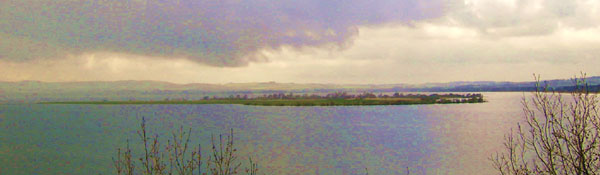 |
| St Serf's Island |
Another charter (St A.Lib. page 1) deals with the boundaries
of Kirkness on its western and southern sides, which separate
it from Balingry. Again Simon Taylor has dealt with this
charter at length and provides a translation (see benarty.org.uk
for relevant
extracts from Placenames of Fife, mainly pps 1-3).
The charter establishes a reference point, this being
a burn (eventually the Water
 |
| The Water of Lochty
in Balingry crossed by the modern road. This is
the likeliest location of the stony ford of Navitie. |
of Lochty) having its source on Benarty
and running east to the stony ford of Navitie. The boundary
starts here and runs north by a road, past a pile of
stones called the Lykyrstyne (Likarstane), towards Findatie;
this is the western boundary of Kirkness. The boundary
to the south is straightforwardly the Water of Lochty.
Taylor makes a convincing case for the Likarstane having
been located on a parish/county boundary about 400 metres
west of West Mains of Kirkness as shown on an old estate
plan. He notes that Lawrie had mistakenly suggested
the Likarstane to be the same as the rock of the Hibernians.
Likarstane has been thought to indicate a resting place
for a coffin being taken to church for burial - see
DSL.
 |
| The well at Scotlandwell |
Three charters (St A. Lib. pages 43, 146
and 176) refer to hospitals next to bridges of Porthmooch
and of Lochlevyn. There is some uncertainty as to whether
these are two separate hospitals or one and the same,
particularly because of the establishment at Scotlandwell
which may be identical to one of them (see Mark Hall,
Liminality and Loss, page 396 in West over Sea; D E Easson,
Medieval Religious Houses (Scotland); Simon Taylor, The
Rock of the Irishmen op.cit).
Interpretation
All these charters seem to be related to the road
coming from Inverkeithing. The first charter, which
mentions the road explicitly, has it run from Inverkeithing
and has it as a boundary north of the Lochty and running
up towards the Leven. The second charter ties this down
more closely from the ford at Navitie and running north
by the Likarstane. The final three charters, whether
there is one bridge or two, would take the road across
the Leven to Scotlandwell and beyond.
 |
| Possible line of
road. Other roads in the area are shown. Based on
quarter-inch OS map, sheet 3, 1923. With thanks. |
It is unlikely that we can recover the route taken
from Inverkeithing, other than to assume it would have
ran fairly directly. Early maps show several routes
heading north from Inverkeithing but as they do not
show any through route to the Portmoak area we cannot
use that as a guide. However, as other charters show,
the Kinross route from Inverkeithing ran through Crossgates
and up towards Kelty at this time. There is every chance
that the Portmoak route was the same to just north of
Crossgates where it would have branched off towards
the Ballingry area of the charter, and keeping east
of Loch Ore.
 |
| The Gullet runs
for 4 miles. By lowering the water level in Loch
Leven it created some 1100 acres of new land. The
view is from the New Gullet Bridge - the nearby
Old Gullet Bridge crossed the old course of the
Leven. |
The second charter gives us a good idea of the course
between the Lochty at the ford of Navitie and Scotlandwell.
It is very likely that once the low lying
ground near the loch was reached the going would have
been difficult. At this time the surface of Loch
Leven was higher - in 1828 a scheme was started to lower
the level of the Loch by the straightening of the River
Leven as it emerges from the loch along with measures
to provide a regular flow of water for the mills along
the course of the river (NMRS
record). The change in the shoreline can be seen
from early maps with Portmoak and Lochend being closer
to the water and the Leven having a different course.
The better drainage would have helped make the ground
here less marshy.
The marshy nature of the ground is confirmed by an
item for 1642 in the Register of the Privy Council of
Scotland (Register
of the Privy Council, Second Series, vol. VII, 1638-1642,
page 303 - may show as page 380 on Internet Archive.
Publ. 1906). This mentions a bridge on the old course
of the Leven and the extremely poor condition of the
road to Scotlandswell. The route (between Edinburgh
and Perth and elsewhere) was impassable "be reason
of a ruinous bridge at the east end of Lochlevin called
the Gullats, and in regarde of manie deepe ditches and
sinkeing myres betuix the said bridge and the toun of
Scotlandwell, commonlie called the caises of Scotlandwel,
quhairthrow diverse of his Majesties subjects have perished,
manie have beene in hazard of thair lyffes, and all
are hindred in thair lawful affaires that way.."
The Privy Council recommended a collection towards the
upkeep of the bridge and causeway, and authorised tolls
for the space of nine years.
Whether the last of the charters are
referring to one or two bridges, the Leven would have
to have been crossed. As suggested by Taylor this was
probably at the above "ruinous bridge" at
the Gullat or a forerunner of it at, or close to, the
Old Gullet bridge.
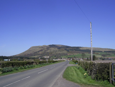 |
| The Causeway approaching
Scotlandwell - it still retains its name. Bishop
Hill is in the background. At one time this would
have been little better than a swamp. |
It is interesting to see the mention of the causeway
and one wonders if this is the reason for the use of
the term strata for the highway here, i.e that attempts
were made as early as the middle ages to form a road
across marshy ground by piling materials along its course.
The alternative of there being a Roman road here is
unlikely - there is an antiquarian tradition of a camp
near Loch Ore a few miles to the south but this has
never been confirmed.
As to its final destination, while this was a route
to Perth in 1642, presumably by Glenfarg and the Path
of Dron, it is not clear if this applied in the middle
ages as well. We know from a Melrose charter that a
route to Perth led through Kinross on the other side
of the loch but it is not impossible that this did the
same. It would certainly allow access to places north
of the Lomond Hills and the whole area of Portmoak and
Scotlandwell would itself have been a destination for
pilgrims. There is however a possibility that the route
continued directly to the east through the Leslie, Markinch
and Kennoway areas to St Andrews as suggested by Peter
Yeoman (Pilgimage in Medieval Scotland, Batsford/Historic
Scotland, 1999, pps.57 - 59).
St
Andrews
Carta Arnaldi episcopi de terra que est a uico inter burgum
et nouum hospitale (page 127)
A charter of Arnald, bishop of St Andrews, gave St
Andrews Priory some land which lay "from the street
between the burgh and new hospital as far as the stermolind
bridge and from there as the Kinness Burn falls into the
sea. And by the road which goes from the burgh to the
church and so to the sea..."
Various charters confirm this gift and mention the
same boundaries.
totam terram que est a uico que est
inter burgum et nouum hospitale usque ad pontem stermolind
et inde sicut fluuius kines cadit in mare. Et per uiam
quae itur a burgo ad ecclesiam iterum usque in mare.....
Interpretation
Map
(from History of St Andrews, Charles Rogers, p.68)
The charter appears to refer to an area south of the
Priory and Cathedral and within the Abbey Wall. The
Stermolind was originally a ford at a mill on the Kinness
Burn, then a bridge and later renamed Shore Bridge (cf.
Handbook to St. Andrews, D. Hay Fleming, Page 106).
The road to the shore can be seen on the map.
The likeliest destination for the route using this
early ford and bridge would be Anstruther and Crail,
as suggested by Barrow, for example (Scotland &
its Neighbours in the Middle Ages, pps 207 & 215)
For further details see POMS
Other charters
A few charters refer to a place in
St Andrews (Kilrymont) called Turdaphe e.g. page 234
......Also the land outwith the burgh in the north street
near the crossroads and near turdaphe�
....... Terram
eciam extra burgum in uico North apud furcas et apud
turdaphe...
Various charters (see index of St. Andrews Liber) refer
to the north and south streets and one or two other
streets in the town.
Several charters mention the hospital in St Andrews
"for the sustenance of the poor and of pilgrims" (e.g.
p.148, 150 ) The hospital was located near the cathedral
and was known as St Leonard�s.
Crail
Carta comitisse Ade de terra in karal
St Andrews Liber, page 208
Countess Ada gave St Andrews priory some land in Crail
defined as:
..... that land in Crail which Radulfus of Aluerbas
inhabited above the road and below the other road which
is next to the toft of the abbot of Dunfermline and
below the old fosse and stream and that land below the
road from the toft of Radulfus of Morpath as far as
the sea��.
.illam terram in charel quam radulf
de aluerbas inhabitauit desuper uiam infra aliam uiam
que est iuxta toftum abbatis de Dunfermelin et infra
ueterem fossam et riuulum et illam terram subtus uiam
a tofto Radulfus de morpath usque in mare �.
This land is also mentioned on page 210 and 234 of
the St Andrews Liber.
Interpretation
Although it would be difficult to identify this
piece of land today, there is no particular need to
do so as the layout of Crail is easily seen on the 25"
maps (Fifeshire, 023.02 & 016.14) where it has
not changed much from the middle ages.
Markinch
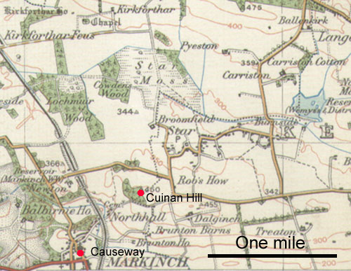 |
| Based on the 1926 one-inch map
for Dundee & St Andrews. With thanks to Ordnance
Survey. |
A charter of William of Vallence dating from 1284 refers
to land which he gave to St Andrews Priory (St Andrews
Liber, page 420). As part of the boundary there was
a causey (calcetum) which from the context was in the
centre of Markinch near the cemetery. Simon Taylor has
translated the charter (Knowing Your Place: A Placename
Walk on Markinch. Markinch Heritage Group, Dr Simon
Taylor. Pdf
leaflet (4.14 Mb) as well as providing interesting
information about placenames in the locality. See pps.6
& 7.)
Interpretation
The causeway is likely to have been over some marshy
ground in Markinch itself.
See also Rural
Walk leaflet, and Brae
Loans Project (Markinch Heritage Group) on an old
track across Cuinan Hill and Star. The old track may
be part of an early pilgrim route to St Andrews (see
Pilgrymgath below) and the word "star" is
Gaelic for a "crossing" thought to relate
to the marshy ground north of Star.
For other charters relating to Markinch parish see
here
Largo
(Lundin)
Two charters record a donation of 20 acres of land by
Walter of Lundin to St Andrews Priory. The land was
next to his lake of Lundin on the north side along with
a toft which Gillemuir had, namely, from the house of
the smith to the road and with common pasture.
....viginti acras terre iuxta lacum
suum de Lundin a parte aquilonali cum una tofta quam
Gillemur tenuit scilicet a domo fabri usque ad uiam
et cum communi pastura....
• St Andrews Liber, pps 231
& 263
• POMS Document
3/369/2 (St A. Lib., 263-4)
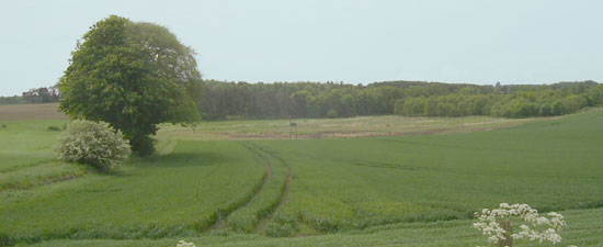 |
| Old lake bed at Lundin. The
tower is just to the left. Click for larger image. |
Interpretation
Lundin is in Largo parish, a couple of miles north east
of the town of Leven, where the remains of a tower dating
back to the middle ages can be seen. Old maps do not
show any loch in the area but there is an old lake bed
just west of the tower. It is not very large, perhaps
200 metres or so in diameter but large enough to be
called a lake.
 |
| Based on the 1926 one-inch map
for Dundee & St Andrews. With thanks to Ordnance
Survey. |
The likeliest reading of the charter is that the land
was south of this lake with a road trending from east
to west but without more information it is hard to say
where the road originated and what its destination was.
It could have been a main road or one of a number of
roads leading to different parts of the estate.
LOGIE (Kedlock)
 |
| Based on 1914 half-inch OS map,
sheet 24. With thanks to Ordnance Survey. |
Carta Simonis filii Simonis de Kyner de terra in
kathlac
Charter of Simon, son of Simon of Kinner of lands in
Kedlock
St Andrews Liber, Page 292
This is a gift of "5 bovates of land (bovate =
15 acres approx.) and 4 acres in the territory of Kedlock,
namely 2 bovates and 4 acres which begin from the acre
of the brothers of St Lazarus, and extend as far as
a sike on the south side and from there to the land
which was a certain Reginald's towards the west side
as far as the bounds of the land of Matthew, one time
(late) brother of John of Kinner and so northwards as
far as a certain path which lies next to the mountain
called Adkar with a toft adjacent to the same land.
And 3 other bovates which begin on the north side of
the same ville and reach as far as the moor in length.
And in width from the west part of the moor as far as
the eastern part of the same moor in circumference..."
quinque bouatas terre et quatuor
acras in territorio de kathlac. Scilicet duas bouatas
et quatuor acras que incipiunt ab acra fratrum sancti
lazari, et se extendunt usque ad unum siket, ex parte
australi inde se extendunt ad terram que fuit quondam
Reginaldi versus partem occidentalem usque ad metas
terre mathi quondam fratris Johanis de kyner et sic
versus aquilonem usque ad quamdam semitam que iacet
iuxta montem que uocatur adkar cum tofto ad eandem terram
adiacente. Et tres alias bouatas que incipiunt ex parte
boreali eiusdem uille, et se extendunt usque ad moram
in longitudine. Et in latitudine ab occidentali parte
more usque ad orientalem parte eiusdem more per circuitum�.
Further Information
POMS
Interpretation
Kathlac is now Kedlock, three miles north of Cupar.
One wonders if the second part of the charter referring
to the northern part of Kedlock means that the first
part is referring to south of Kedlock. If so, the parish
boundary may hold a clue here if we start near Craigsanquhar
as it runs south to a sike or burn (Moonzie Burn) which
would then run along the south side of the land. As
it approaches Reginald's land (see next charter), the
boundary of which, following Taylor, would be the road,
it would turn north to the path next to Adkar. This
would identify the hill called Adkar either as Myrecairnie
Hill or Kedlock Hill, as suggested by Taylor. It is
likely to have been for local access only.
-----------------------
Charter
39 of the Balmerino cartulary is for certain lands
in the territory of Cathloc (Kedlock). G W S Barrow
discovered a fuller version, a transcript of which is
available on the Syllabus of Scottish Cartularies, Balmerino,
page 27. It is a very useful charter because it
mentions a via regia when detailing the boundaries of
the territory.
A translation is given by Simon Taylor (Place Names
of Fife, vol.4, page 555) where he identifies the via
regia as the road leading north from Cupar past Foodieash
and Kilmany to the ferry at Woodhaven. It must have
intersected another via regia which was mentioned in
a Balmerino charter for Gauldry which led to the ferry
of Portincrag. There is a strong likelihood that it
is the same via regia as the one in Kilmany parish,
north of Kinnear - see here.
Forgan
- Friarton
Two charters deal with some land in Forgan parish,
near to Friarton and Cowbackie and mention roads.
 |
| Map based on 1914 half-inch
OS map, sheet 24. With thank to Ordnance Survey.
|
Carta Ricardi de Lasceles de tribus acris terre
de Frereton (St A. Lib., Page 274)
A charter of Richard Lascelles granted St Andrews
Priory three acres of land in Friarton, namely:
.......three acres of land with appurtenances, from
the east side of the land of Friarton and on the north
side of the road which leads from Friarton to the church
of Forgrund, by the divisions of the causeway on the
one hand, the syke on the other, and heaps of stones
next to the road from Inverdovat towards St Andrews
on the third hand.....
.......tres acras terre cum pertinenciis
ex parte orientali terre de freretone et ex parte aquilonali
uie que tendit de freretone ad ecclesiam de forgrund
per diuisas calceti ex una parte, et sicketti ex altera,
et congeriei lapidum iuxta uiam de Inuerdoueth uersus
sanctam andream ex tercia.......
Interpretation
If we assume the "east side of the land of Friarton"
was close to Easter Friarton then it is likely that
the road to Forgan church had much the same line as
the present day road; the "syke" would have
been the burn which forms the parish boundary here.
The course of the road from Inverdovat is uncertain:
it may have crossed Roseberry Hill, passed Easter Friarton
and taken a fairly direct line to St Andrews through
Leuchars and across the forerunner of the Inner Bridge
over the Mottray (see ), but slight deviations from
this line could have been possible. Early maps (NLS)
are unhelpful: there is a track that crossed Roseberry
Hill but its age is uncertain and Ainslie in 1775 shows
a straight road from Myreside towards Leuchars but again
its age is uncertain. They may have the same line as
the road of the charter but are not necessarily identical
to it. The causeway is difficult; perhaps it was just
to help cross marshy ground locally rather than be a
part of a long distance route.
=======================
Carta Alani de Lasceles de II acris terre in parochia
de Adhenauthen (see notes page 7) (St A. Lib.,
Page 274/275)
Another charter, by Alan Lascelles, gave St Andrews
two acres of arable land, and an acre of meadow in the
parish of Naughton (which at that time included much
of Forgan). Campbell (Balmerino & Its Abbey: A Parochial
History, James Campbell, 1868, page 21) translates this
as:
...........two acres of arable land which are near to
the vill of Culbakin (Cowbakie) extending northwards
from the road which leads from Alan's own vill to Culbakin
with one acre of meadow land measured westwards from
Culbakin between the said two acres and the land of
Malcrether belonging to the canons of the said Priory...
duas acras terre arabilis de terra
mea in parochia de adhenauthen, videlicet, illas duas
acras que propinquiores sunt uille de culbakin pertendentes
se a uia qua itur de uilla ipius alani usque ad culbakin
(Cowbackie) uersus aquilonem cum una acra prati mensurata
a terra de culbakin uersus occidentem inter dictas duas
acras et terram predicto canonicorum de malcrether.....
Interpretation
Without knowing where Alan resided it is difficult
to say much about this road other than it would have
ran west or north west from Cowbackie (now Vicarsford)
or the western boundary of Cowbackie to his residence.
• SPNS Notes-http://www.spns.org.uk/oldnotes5.html
(Autumn 2006 The Place-Names of Fife, Simon Taylor)
•
Balmerino & Its Abbey: A Parochial History, James Campbell,
1868
Leuchars
- Bridge Over Mottray Water
Two charters (St Andrews Liber, pages 275, 341) dating
from the early 1200's mention a bridge over the Modrith,
near Seggin.
Interpretation
This would have been the Inner Bridge or a forerunner
of this over the Motray Water just north of Guard Bridge.
The present day Inner Bridge is probably 18th century
but the NMRS record says that the "inner brig"
was repaired in 1598. It is shown on a map by Gordon/Pont
dating from much the same time.
Dairsie
In an agreement between Hugh, Bishop of St Andrews
and Earl Duncan, concerning a mill in Dairsie, mention
is made of allowing reasonable access to the mill.
St Andrews Liber Page 353
POMS - this gives a full translation
Interpretation
This is very localised.
---------------------------------------------------
In a document Master Lawrence, archdeacon of St Andrews
states that he has received some land from the Priory
"which lies on the south side of the road which
goes from St Andrews to near Dairsie, namely, the land
which is between.....which is divided between them and
the common...St Andrews assigned and to the summits
of the mountains and the river which flows from the
south side of the said road...."
ex australi parte vie que itur a sancto
andree apud deruesyn scilicit terram que est �nter.....
quod est diuisa inter eos et communem..... sancti andree
assignatam et supercilium montis et riuulum qui fluit
ex australi parte predicte vie.....
• St Andrews Liber Page 27
•
POMS - this gives full details with a translation
Interpretation
This appears to be the medieval road between
Cupar and St Andrews that ran through Dairsie and Strathkinness.
See also Dairsie Bridge below
Granges
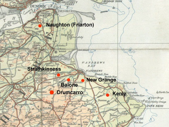 |
| Although we have no specific
information about routes used by the granges it
is likely that Strathkinness would have used the
Cupar-Dairsie-St Andrews route or the Bishop's Road,
with Balone and Drumcarro joining this. A track
probably led directly from New Grange to St Andrews
and Kenly is likely to have used the road from Crail.
Friarton may have used the road from Inverdovat.
Destinations other than St Andrews would have been
possible, especially for markets. Based on quarter-inch
OS map, sheet 3, 1923. With thanks. |
St Andrews Cathedral Priory had granges at the following
places:
1. Kellakin, now Kenly - 5 miles SE of St Andrews.
2. Balochen, now Balone- 2 miles WSW of St Andrews.
3. Strathkinness - 4 miles W of St Andrews.
4. Drumcare, now Drumcarro - five miles SW of St Andrews.
5. Adnachten, now Naughton (Friarton) - two miles SSE
of Newport on Tay.
6. Grangia Nova, now New Grange - one mile S of St Andrews.
• St Andrews
Liber - Index
• Derek Hall, Scottish
Monastic Landscapes, Tempus 2006
Berwick on Tweed
Two charters for Berwick on Tweed refer to the uia
pontis (bridge street or briggate) (page 387) and the
Briggegate (page 391).
A charter of Robert de Bernham (page 272) refers to
some land near the Tweed on the west side of that street
which leads to the east.
Perth
A charter in the St Andrews Liber (page 142) mentions
a toft in North Street near the castle
.....uico de north apud castellan....
Bridge
of Spey
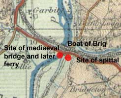 A
very early bridge spanned the River Spey near Boat of
Brig in the North-East of Scotland. There was an associated
hostel/hospital for poor travellers, possibly pilgrims.
When the bridge decayed around the time of the Reformation
it was replaced by a ferry, hence the "Boat of
Brig". The charter in question (St. Andrews Liber,
page 326) was an agreement between St Andrews Priory,
the bishop of Moray and Lady Muriel of Rothes that St
Andrews would quitclaim their rights in the church of
Rothes to the hospital, and would receive 3 marks each
year in return. For further details see here
and POMS. A
very early bridge spanned the River Spey near Boat of
Brig in the North-East of Scotland. There was an associated
hostel/hospital for poor travellers, possibly pilgrims.
When the bridge decayed around the time of the Reformation
it was replaced by a ferry, hence the "Boat of
Brig". The charter in question (St. Andrews Liber,
page 326) was an agreement between St Andrews Priory,
the bishop of Moray and Lady Muriel of Rothes that St
Andrews would quitclaim their rights in the church of
Rothes to the hospital, and would receive 3 marks each
year in return. For further details see here
and POMS.
Easter
Fowlis
Charters of William Maule and Roger Mortimer
These are dealt with under Angus.
They refer to a grant of the church and some land in
Easter Fowlis, 6 miles west of Dundee.
Kirkden
Ordinacio Walteri episcopi de Edwy
This is dealt with under Angus.
It refers to the re-siting of the glebe of the church
of Idvies (later Kirkden) and mentions a ford over the
Vinny Water at a rock called Craignacre.
Bourtie
Two charters refer to a gift of the church of Bowird
(Bourtie, between Inverurie and Old Meldrum) and some
land in which a road towards the north is mentioned.
They are dealt with under Aberdeenshire.
OTHER
SOURCES
Two of these references are for bridges, viz. Guardbridge
replacing a dangerous river crossing to the west of
St Andrews and Dairsie Bridge that was on an early route
from Cupar to St Andrews.
The charter for the lands of Cameron in Markinch parish
refers to a highway going to Kirkcaldy but it is not
immediately clear what route it had. There is an old
road in the near vicinity but it is not certain that
it is the same road - this is Queen Mary's road said
to have been used by her to travel between Wemyss Castle
and Falkland. There is an old bridge on the route.
In Ceres parish, two roads are of interest. One is
the Pilgrimsgath which probably came up from Kennoway;
although it is not clear how it continued to St Andrews.
The other is the Waterless Road or Bishop's Road that
can be traced on fairly recent maps between Kennoway
and Ceres. An old bridge there continues its route on
the old line by St Andrews Wells, Upper Magus, and Magus
Moor where Archbishop Sharp was attacked and killed
by a party of Covenanters in 1679.
Guardbridge
 Built
in the early to mid-1400s by Bishop Henry Wardlaw and
repaired several times, notably by Archbishop Beaton.
It crosses the river Eden just over 3 miles west of
St Andrews and would have served those travelling to
St Andrews from Cupar and from the Tay. It was superseded
by a new bridge in 1938. (NMRS
record) Built
in the early to mid-1400s by Bishop Henry Wardlaw and
repaired several times, notably by Archbishop Beaton.
It crosses the river Eden just over 3 miles west of
St Andrews and would have served those travelling to
St Andrews from Cupar and from the Tay. It was superseded
by a new bridge in 1938. (NMRS
record)
As Simon Taylor notes, there was no previously existing
bridge - PNF, v. 3, p. 45. People did ford the Eden
but it was extremely dangerous.
Dairsie
Bridge
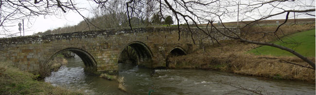
A bridge is noted here in 1496 when James IV passed
over it. It was probably rebuilt or replaced by Archbishop
Beaton whose episcopate ran from 1522 to 1538, as he
has an armorial panel on the current bridge. It crosses
the Eden and is on the early (medieval) route betwen
Cupar and St Andrews.
Markinch
- Cameron
Memorials
of the family of Wemyss of Wemyss (1888).
Sir William Fraser
Vol 2, No 2, Page 4 c.1290. Abstract page v.
Charter by John of Anesley, knight, to John of Wemyss
and Amabilla his spouse, daughter of the granter, granting
to them his whole land of Over Cambrun, with the common
of Nether Cambrun, with pertinents, liberties, and easements,
by the following marches, viz.:
As Gamlisburn descends into the water of Leven, and
by Gamlisburn ascending to the lands of Robert Galle,
and as far as the Scortbutis, and so from the land of
Robert Galle towards the east as far as the field called
Langebrekes, and from Langebrekes ascending to the highway
going towards Kyrcaldin, and from that highway descending
between the land of Fergus and the land called Spiteland
as far as the Keldeney, and so ascending from the Keldeney
as far as the Harlawe, which is in the marches between
Michael of Wemes and Cambrun (from Abstract)
Note: The translation has been amended
to take account of the following points:
- Fraser notes an uncertainty in the original Latin
text "et de Langbrekes ascendendo usque ad aliam
(altam?) uiam tendentem versus Kyrcaldin; et ab illa
alta via... It makes much more sense if it is rendered
as "and from Langebrekes ascending to the highway
going towards Kyrcaldin, and from that highway..."
rather than "ascending to another highway"
- Spiceland in the original but should be Spiteland
as noted by Taylor (PNF, 1, 580)
- Keldeney in the original charter is "le Keldeney"
and Harlawe is "le Harlawe".
 |
| Parish boundary , c. 1775, in
green. Based on half-inch OS map sheet 24, 1914.
With thanks to Ordnance Survey. |
Interpretation
The map shows the parish boundaries as they were
in the late 1700's (Ainslie) and the locations of Cameron,
Spittal (see Ainslie), and Harelaw. Note the two unnamed
burns near Cameron, one of which may be Gamlisburn.
Maw is noted, as Taylor says that a Henry Gall held
it in 1421, which is just 130 years after the time of
the charter.
There is quite a good fit (though speculative) if we
start at the easternmost of the unidentified streams,
where by following it one would reach Maw. At this point
the charter is ambiguous: it can be read as heading
east from the land of Robert Galle to Langebrekes or
read as keeping the land of Robert Galle behind one,
towards the east i.e. heading west to Langbrekes. To
head eastwards at this point is awkward as it does not
fit well with the location of Spitel.
Continuing west one would reach the highway then descend
(which has a strong implication of heading south) between
the land of Fergus and Spiteland to the Keldeney, then
across to the Harlawe.
While much of this is speculative, there are nevertheless
good fits here and there. As to the location of the
road, it is certainly not a coastal route and any precursor
of the A915 seems too far south. The mention of Spiteland
must place it somewhere near the confluence of the Lochty
and the Ore.
Interestingly there is an old
bridge (NMRS record) nearby, on what is known as
Queen
Mary's Road (Heritage Paths) which she is said to
have used between the coast and Falkland in the mid
to late 1500's. It was also used c. 1800 to take iron
ore from Balgonie to the coast for transport to the
Carron Iron Works; this was in response to complaints
about damage to the main road (The Roads of Fife. Owen
Silver, John Donald, p.130 & 174).
It is not clear if this is our road; it would need
a branch to Kirkcaldy though this is not impossible.
Another route could have been Kirkcaldy to Kennoway
and onwards to St Andrews, about a mile north of, and
parallel to the A 915, but this does not fit the implication
that the highway was north of the Spitelands. A final
possibility, which seems too far west, is a route from
Kirkcaldy north through the Markinch gap (though such
probably existed).
•
POMS
•
Placenames of Fife, Simon Taylor with Gilbert Markus
- Over Cameron Vol.2, 418-19. On other lands in this
charter, see Vol.1, 579-80
Note. A spittal would have been used by pilgrims.
Ceres
- Pilgrimgath
A charter from the early to mid 1300's for part of
the lands of Gaskerduf in Ceres parish has a reference
to the Pilgrimgath, a route used by pilgrims travelling
to St Andrews. A translation of the charter is available
online at the St Andrews University Library, viz. ms37490
Collairnie Charters - charter 1. See also Placenames
of Fife, v. 2, p. 56 - 57 and POMS.
Interpretation
 |
| Based on the 1926 one-inch map
for Dundee & St Andrews. With thanks to Ordnance
Survey. |
Unusually for a charter of this date, many of the
placenames are easily identified, as shown on the map.
The Coalpots would have been near Teasses where the
6" map series shows quarries and "old coal
pits" and where an old track leads westwards. Just
south of Gaskerdo there is some high ground which would
be a prominent position for a cross with the parish
boundary a short distance beyond and Prates about one
mile to the south. The parish boundary follows a burn
northwards past Kames and joins the Glassy How Burn
both of which fit the description of the Fedynath and
the water of Hothirstrothir. From this one would expect
the road to intersect the parish boundary just south
of Kame.
For its continuation southwards, it may be significant
that a parish boundary follows the road past Prates
for three quarters of a mile. From here it is less than
three miles to Kennoway, with the present day road aligning
again with parish boundaries for a further half mile.
From Kennoway, a route along the coast would be easily
reached as well as one from Scotlandwell, another destination
for pilgrims, through Markinch, as suggested by Peter
Yeoman in Pilgrimage in Medieval Scotland (Batsford/Historic
Scotland, 1999, pps.57 - 59).
At its northern end, near Teasses, the route is now
lost. One could conjecture it ran up to Ceres or continued
in an easterly direction but additional information
would be needed to track the route accurately.
 |
| The "Waterless
Road" near Struthers looking in the direction
of Ceres. |
The Pilgrymgath has to be distinguished from the old
road running south-west from Ceres. Known as the Waterless
Road as it follows drier ground along a ridge, it lines
up with the old bridge in Ceres which dates from the
17th century. The road in fact can be followed on old
maps as far as Kennoway (NLS),
seven miles to the south.
From Ceres to St Andrews, the road became known as
the Bishop's Road, probably because it was used by them.
When travelling along it, Archbishop Sharp was killed
in 1679 by a party of Covenanters. Ainslie shows it
to Pitscottie then passing St Andrews Wells, Upper Magus,
Magus Moor and running directly to Carron. It is also
shown on Roy.
• Owen
Silver, The Roads of Fife, John Donald, 1987, pps. 68,
170
•
Heritage Paths site
• Placenames of Fife,
Simon Taylor with Gilbert Markus, Vol. 3, p. 451.
Top
|