|
Glasgow
The Origines Parochiales Scotiae (OPS) notes that Alexander
II said that "Rutherglen should not exact toll or custom
within the town of Glasgow but only at the cross of
Schednestun (now Shettleston) as they used formerly
to be levied."
Reg.
Glasgow, page 114
Alexander II on making Dumbarton
a royal burgh in 1242 allowed Glasgow�s burgesses and
the men of Glasgow to "retain their rights of trade and
merchandise through Argyll & Lennox which they had anciently
enjoyed."
See Nos. 8, 10 & 12 on this page
(British History online).
Monklands
Newbattle Abbey had received extensive grants of land
in what is now Monkland and Carmyle. In order to reach
these lands they negotiated rights of way with landowners
along the route from Newbattle. See The
Road to the Monklands for further details.
Lanark
 In
1492, James IV confirmed a grant made by a Simon Lockhart
of Cleghorn of the "place of Clydesholm and the passage-boat
upon the Clyde" to maintain a chaplain at the Altar of
St Catherine in the chapel of St Nicholas in Lanark. In
1492, James IV confirmed a grant made by a Simon Lockhart
of Cleghorn of the "place of Clydesholm and the passage-boat
upon the Clyde" to maintain a chaplain at the Altar of
St Catherine in the chapel of St Nicholas in Lanark.
OPS,
Vol I, page 119
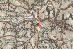
Identification
Clydesholm, just upriver from Kirkfieldbank. For
further information see here.
Carnwath
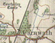 A
causeway one mile in length ran between Couthally House
and Carnwath. In 1489 James IV used the causeway to walk
to the House. A
causeway one mile in length ran between Couthally House
and Carnwath. In 1489 James IV used the causeway to walk
to the House.
OPS,
Vol I, page 128
Douglas
 The
OPS refers to a charter of 1348 regarding the lands of
the Sandylandis and the Ridmire with the "east part
of Pollynfegh (Poufech) as the water of Douglas runs upwards
to the two trees of Byrks, on the west part of Halleford
over against Haynyngschaw which is in the barony of Lesmahago." The
OPS refers to a charter of 1348 regarding the lands of
the Sandylandis and the Ridmire with the "east part
of Pollynfegh (Poufech) as the water of Douglas runs upwards
to the two trees of Byrks, on the west part of Halleford
over against Haynyngschaw which is in the barony of Lesmahago."
Identification
Although Sandylands and Ponfeigh appear on maps the
other places do not, making it difficult to say where
the Halleford was other than it was near Ponfeigh. A
route to Douglas might be indicated.
Lesmahagow
Kelso Abbey had been granted the lands of Lesmahagow by
David I in 1144. The original charter and a number of
other charters survive, and some mention roads and fords.
The charters are referred to in several works. Thus Cosmo
Innes, editor of the Origines Parochiales Scotiae (1850),
details the charters. G Irving and A Murray also wrote
about them in the Upper Ward of Lanarkshire (1864) as
did J B Greenshields in the Annals of Lesmahagow (1864).
More recently Ruth Richens in a paper on Ancient Land
Divisions in the Parish of Lesmahagow (1992) has re-examined
the charters, and besides identifying the boundaries more
closely has shown how some of these have persisted to
the present day.
Corroc
A charter dated sometime between 1147 and 1160
describes lands near Douglas Water, viz. "from the source
of Polnele, as that water runs to the Water of Douglas,
and from the source of Polnele, beyond the broad moss
to the long fau, thence to Hirdlau, thence to Thievesforde
in Mossminine and Corroc, and so to the long Black ford,
and so as the way runs to Crossford."(OPS)
L.de
Calchou page 78, charter107; OPS
111; Monastic Annals 147; Greenshields
44; UWLanarkshire
224; Richens 188
Another charter of the late 12th century gives the boundaries
of Corroc, saying that it was "bounded by the road leading
from Crauford (marked in other cases as the junction
of the Douglas and Clyde) to the Kirkeburn, (called
also the burn of Dowane,) and by that burn to the Clyde�."
(OPS)
L
de Calchou page 82, charter 112; OPS 112; Greenshields
68; UWLanarkshire
212; Richens 188
Interpretation
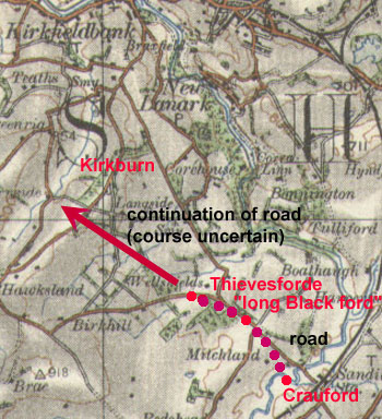 The
position of Thievesforde is shown on early maps (NS873
399) on a stream that runs into the Clyde. The long
Black ford is identified in the OPS as Blackford in
Bogside though it is not clear if the Bogside near Lesmahagow
(NT825 410) is meant - this would be unlikely as the
OPS identifies Crossford/Crauford as the junction of
the Clyde and Douglas rather than the Crossford near
the Nethan, NW of Lanark. Greenshields notes that some
had placed the long Black ford near Blackhill of Stone
byres (NT 8343) and Crossford at the present day Crossford
NW of Lanark but suggests they were both on Douglas
Water. The UWLanarkshire continues the second of the
above charters which then reads, "as the road goes from
Crawford to the burn which is called Kirkburn, and by
that burn into Clude, and on the other side as the Douglas
descends from Crawford into Clude." This is a clear
indication that there was a Crawford on the Douglas
somewhere above the confluence with the Clyde. The
position of Thievesforde is shown on early maps (NS873
399) on a stream that runs into the Clyde. The long
Black ford is identified in the OPS as Blackford in
Bogside though it is not clear if the Bogside near Lesmahagow
(NT825 410) is meant - this would be unlikely as the
OPS identifies Crossford/Crauford as the junction of
the Clyde and Douglas rather than the Crossford near
the Nethan, NW of Lanark. Greenshields notes that some
had placed the long Black ford near Blackhill of Stone
byres (NT 8343) and Crossford at the present day Crossford
NW of Lanark but suggests they were both on Douglas
Water. The UWLanarkshire continues the second of the
above charters which then reads, "as the road goes from
Crawford to the burn which is called Kirkburn, and by
that burn into Clude, and on the other side as the Douglas
descends from Crawford into Clude." This is a clear
indication that there was a Crawford on the Douglas
somewhere above the confluence with the Clyde.
Richens suggests Crawford was near Douglasmouth Bridge
and the long Black ford was a route through marshy ground
between Thievesford and Crawford.
From the above it is clear that there was a ford over
the Douglas called Crawford from where a road ran through
boggy ground up to Thievesford and continued up to the
upper reaches of the Kirkburn. It is not clear what
the origin and purpose of this road was and where it
continued beyond the Kirkburn and Douglas Water, though
Lesmahagow and Biggar are possibilities.
Draffan
A charter from the time of Abbot Henry (1208 - 1218)
relating to Draffane and Dardarrach says, "on the one
side as the burn descends from the moss to Naythan and
from Naythan into Clyde at Holyn de Pintaurin towards
the east and so up that burn to the old ditch and from
the old foss to the road which goes between the moss
and the hard land to Polneanske and on the other side�."(Greenshields)
Lib.
De Calchou page 76, charter 103; Greenshields
51; UWLanarkshire
203; Richens 187
Interpretation
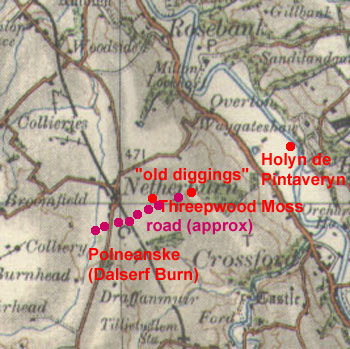 Richens
identifies the locations in this and another charter
relating to Draffan. She places Holyn de Pintaveryn
on the Clyde at NS 822 481 (near Sandyholm) and the
"old ditch" of Greenshield�s translation (she renders
this as "old digging", perhaps for peat or coal) at
NS 811 476, one kilometre east of Netherburn. The moss
is Threepwood Moss and the Polneanske is the Dalserf
Burn allowing us to place the road as running south
of the moss from the "old diggings" over to Dalserf
Burn, a distance of just over a kilometre. Richens
identifies the locations in this and another charter
relating to Draffan. She places Holyn de Pintaveryn
on the Clyde at NS 822 481 (near Sandyholm) and the
"old ditch" of Greenshield�s translation (she renders
this as "old digging", perhaps for peat or coal) at
NS 811 476, one kilometre east of Netherburn. The moss
is Threepwood Moss and the Polneanske is the Dalserf
Burn allowing us to place the road as running south
of the moss from the "old diggings" over to Dalserf
Burn, a distance of just over a kilometre.
The origin and purpose of the
track is unclear, nor if it continued beyond these points.
It may have been connected with the "diggings" but this
is not certain.
Fincurrock
A charter of the early 1200�s (Greenshields says Abbot
Henry 1208-18) refers to part of Fincurrocks defining
it as "the Pollenoran falls into Clyde, and so up the
Pollenoran to the leading syke between Gilbertstun and
Gilmehaguston, and following it to the burn, and up
the burn to the Black ford in the bog, and by the leading
syke in the bog to Elwaldesgate, thence to a little
burn falling into Culnegaber, and by that burn downwards
to the ditch on Esbert�s croft, and thence by the little
burn downwards to the great burn of Dunelarg, and so
up that great burn to the ford of the road that leads
from Lesmahagow to Lanark, and up that road into Dularg,
as far as the slender cross (gracilis crux,) and thence
to the adjoining valley, and down the burn of Ancellet
into Clyde." (OPS)
Interpretation
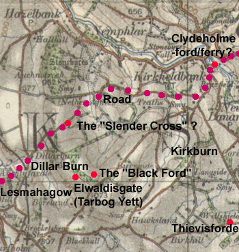 Greenshields
notes that it is difficult to trace these boundaries
but tentatively suggests Pollenoran was the Kilbank
Burn (presumably the Kirkfield Burn - see 1:25,000 OS
map), Blackford was Blackhall, the dry course (his translation
is different from the OPS) in the bog was a gorge at
Bogside between Dillar and Dumbraxhills, and the Ancillet
was the burn at Hallhill. Greenshields
notes that it is difficult to trace these boundaries
but tentatively suggests Pollenoran was the Kilbank
Burn (presumably the Kirkfield Burn - see 1:25,000 OS
map), Blackford was Blackhall, the dry course (his translation
is different from the OPS) in the bog was a gorge at
Bogside between Dillar and Dumbraxhills, and the Ancillet
was the burn at Hallhill.
Although Richens differs from
Greenshields with some of these identifications we need
only be concerned with the reference to Elwaldesgate
and to the road, that it ran from Lesmahagow to Lanark
through Dunelarg and then past the "slender cross".
She suggests Elwaldesgate could
be Tarbog Yett (NS 836 412) with the Black ford a few
hundred metres east of this near the source of the Linn
Burn - interestingly she notes that there is a row of
boulders along this line.
As the Doularg Burn is Dillar
Burn and the road crosses it, it must have been very
close to the present road (B7018). This trends north-eastwards
to reach a high point near Clarkston Farm which would
be a conspicuous place for the cross. From this location,
Richens is able to identify the rest of the places in
the charter - basically the boundary ran down to the
Ancellet which it followed to the Clyde. Both she and
Greenshields identify this as the burn running parallel
with Black Hill on its west side before joining the
Hallhill Burn at Hallhill.
Based on this, it is reasonable
enough to assume the road ran from Lesmahagow on much
the same line as today though it undoubtedly had the
line of the present day minor road between Wester Kilbank
and Kirkfield Road (the road beside the Clyde dates
from turnpike times) from where a ford or perhaps an
early ferry at Boathills could be reached - the earliest
mention of the ferry is in 1492 though it could have
operated well before that time - see Ross
map.
So far as the "Black ford"
and Elwaldisgate go, it is noticeable that they are
less than a mile from the Kirkburn to where the road
from Crauford and Thievesforde ran, on an alignment
that could have led to Lesmahagow though of course this
is not certain.
It is interesting to see that the Military Survey has
a more direct route running between Dillar Hill and
Boreland Hill over to Greenrig but the charter evidence
for the early road being further north cannot be denied.
Lib.
De Calchou page 80, charter 109; OPS,
Vol I, page 112; Greenshields
77; UWLanarkshire
217; Richens 184
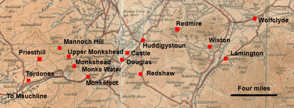
Douglas
(Tordones to Wiston)
Sir William Fraser, in Volume 3 of the Douglas Book refers
to a right of way through the Vale of Douglas which was
disputed between Sir William Douglas and Melrose Abbey,
as follows:
Precept by King John (Baliol) directed to Galfrid of Mowbray,
justiciar of Lothian, narrating that the abbot and convent
of Melros, after having, in presence of the Bishops of
St Andrews and Glasgow and others at Edinburgh, judicially
recovered sasine of a common road within the Vale of Douglas,
in opposition to William of Douglas, knight, who had often
annoyed and harassed them on the said road, which passes
from the bounds of the lands of the said religious of
Tordones, to the church of Douglas, and then before the
park of the Castle of Douglas, through the midst of the
said Vale to Huddigystoun, and so upward to Rayerd, and
thence to the march of the barony of Wystoun; and charging
the justiciar to proceed personally to the said place,
and maintain the abbot and monks in said sasine, and to
apprehend any persons whom he should find interfering
with them, and bring such before the King and his Council.
Rokysburg, 13th April (1294)
From Vol.3,
page viii, Abstracts; original text p.8; see also
Vol.1
p.84. Book digitised by National Library of Scotland.
Above excerpt quoted under Creative Commons license: Attribution-Noncommercial-Share
Alike 2.5 UK: Scotland.
Interpretation
Melrose Abbey had been gifted considerable lands in
central and eastern Ayrshire. One such grant was the
rights of pasture in Kylesmuir, a huge area to the east
that stretched beyond Muirkirk to the boundaries of
Lesmahagow and Douglas. An original requirement for
an annual payment and the retention of hunting rights
by the grantor were eventually ceded so that the abbey
effectively gained complete control of the area. To
administer the whole estate, a centre grew up at Mauchine
though it could be that the mention of Tordones (probably
Tardoes near Muirkirk) implies a more local centre for
Kylesmuir, at least in the early years.
A study of the Account Books of
1527-1528 (The Mauchline Account Books of Melrose Abbey,
1527-1528, Margaret H B Sanderson, AANHS, 1975) has
given much insight into various aspects of life on the
estate including travel. While many journeys would have
been local there are records of longer journeys. These
included the carriage of fish from Ayr and Irvine, journeys
to markets in Lanark, and messengers to places such
as Glasgow and Lanark, as well as to Melrose itself.
 |
| Places mentioned
in the text. Based on quarter-inch OS map, sheets
1 & 2, 1921, 1922. With thanks. |
As far as Melrose is concerned
one would naturally assume a route through Muirkirk
and Douglas but the Account Books imply
a different route with a journey via Priesthill, Lanark
and Carnwath - perhaps heading towards Strathaven to
hit the early route from Irvine and Ayr that came up
the Irvine valley and led to Lanark.
The route mentioned in the document
(some 230 years before the Account Books and perhaps
established soon after the original grant of Kylesmuir,
c.1165) does take this natural route. It
is more than likely that Tordones is Tardoes, just north-east
of Muirkirk, and from where a route to the east would
quickly take one into Douglas parish. Various
placenames a couple of miles east of the present county
boundary indicate that lands here were held by the abbey,
namely Monksfoot, Monks Water, Monkshead, Upper Monkshead
and perhaps Mannoch Hill.
The route is straightforward as
far as Uddington but then becomes unclear as Rayerd
is lost. Fraser suggests Redshaw but this seems an awkward
routing though it could lead to the bounds of Wiston.
Another possibility is a farm called Redmire shown on
the Military Survey map c.1750 near the Howgate crossing
on the western flank of Tinto. The most direct route
from Uddington to Wiston would approximate to the present
day minor road (B7055) that leads to Wiston. From there,
they may have gone to Biggar, crossing the Clyde near
Lamington or up to Wolfclyde which is a couple of miles
from Biggar. The Roman road would have been accessed
at Lamington.
From Biggar the most likely route
would have been by Blythe Bridge and Lyne to Peebles.
References
Liber Sante Marie de Calchou, ed. Cosmo Innes, Edinburgh,
1846 - copy in Internet
Archives
Origines
Parochiales Scotiae, Vol. I, ed. Cosmo Innes, Edinburgh,
1850
Upper Ward of Lanarkshire, G Irving and A Murray, Glasgow,
1864: Vol.1;
Vol.2;
Vol.3
Annals
of Lesmahagow, J B Greenshields, Edinburgh, 1864
Ancient Land Divisions in the Parish of Lesmahagow,
Ruth Richens, Scottish Geographical Magazine, Vol.108,
No.3, pp 184-189, 1992
The
Douglas Book, Vol.3 Charters, William Fraser, Edinburgh
1885
The Mauchline Account Books of Melrose Abbey, 1527-1528,
Margaret H B Sanderson, Ayrshire Archaeological and
Natural History Society, 1975
Top
Back to Mediaeval Roads:
Evidence from Monastic Charters
|