Overview
A large number of monastic
charters for Roxburghshire have survived. Melrose and
Kelso abbeys were particularly favoured with grants in
this area.

From the charters examined so far there are some interesting
findings. At Ednam near Kelso there was a road running
to Kelso and to Sprouston ford. Tenants at Reddon were
required to take corn to Berwick and return with salt
and coal which shows there was a route to Berwick. At
nearby Hadden there was a road to Carham where the Tweed
could be crossed. Near Hadden there was a Prestre-bridge
though the associated route is uncertain.
At Kirk Yetholm, a road ran into
England and there was a bridge at the border. The road
no doubt would have gone to Kirknewton and Wooler and
beyond. In the direction of Kelso it is interesting
to see that a parish boundary runs along a short stretch
of road which may relate to the likelihood of the road
from England continuing to Roxburgh. From Kirk Yetholm
there was a road leading into England along the line
of today's Pennine Way. It is thought that Kirk Yetholm
was part of a lost Anglian "shire" dating
from the 7th century so it is quite possible that these
roads existed at that time.
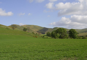
South of here, in the present
day Morebattle and Hounam parishes, Kelso and Melrose
were gifted extensive lands around Mow and Hounam. These
are in two parallel valleys, the Bowmont and the Kale,
on a north-south alignment. Both valleys had roads,
with one running to Roxburgh and one running to Melrose
through Eckford, and it is likely that the roads ran
high up in the valleys given the number of settlements
and cultivation terraces to be found there. In fact,
the road in the Bowmont valley is known as Clennell
Street and runs over the border to Clennell and Alswinton
in Northumberland. As it partly forms the parish boundary
there, it is of mediaeval date at least but its other
name of Emspeth indicates that it is much older.
There was a road between Mow and
Hounam, and in the case of The Street, an example of
a road forming the parish boundary. It continues into
Northumberland as does Dere Street.
In the Lilliesleaf area, a road came
from Selkirk and went on to Jedburgh. In Maxton parish
there was a road between St Boswells and Roxburgh and
a via regia that ran from Roxburgh down to Annandale.
In part it followed the Craik Cross Roman road.
Although not included here, it is
likely that a road ran from Jedburgh to Roxburgh. At Bowden
a short road ran from Elliston to the village.
In Melrose parish, a large number of roads are mentioned.
Chief amongst these was Malcolmesrode thought to have
been made by Malcolm II or Malcolm III (Canmore) to help
consolidate newly won territory in the border region.
An interesting question is whether it is Dere Street or
if that lay a mile or two to the east.
Other interesting roads are one from Lauder to Birkenside
which may have continued to Roxburgh, a road to Windydoors
running across the centre of the territory, and the Girthgate.
Ednam
Kelso abbey was given two and a half
ploughgates of land:
 |
"near
the limits of their land of Kelso, on the north
side of the petary of Ednam, reaching thence along
the boundary of the parishes to the southern bounds
of Newton, and thence along the said bounds to the
river Eden, and along the Eden to the bridge
on the west side of Ednam, and thence to the road
leading to the hospital
(NMRS record), at the forking of the road
which comes from the north side of the petary, and
thence along the road to the place first
mentioned; with the pasturage of a piece of ground
between the petary and the bounds of Kelso."
They were also granted a half ploughgate:
"on the east side of the quarry belonging to
the abbey, between the 14 acres of Paganus de Bosseville
(granted to the abbey and lying in Ednam), the hospital
land, the petary, and the road leading to
Sprouston ford." (from
Monastic Annals) |
Monastic Annals, page
113; Liber Kelso, charter
14, page 18
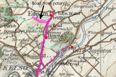 Ednam
lies a couple of miles NNE of Kelso and the hospital about
one mile south of Ednam on the Kelso road. Ednam
lies a couple of miles NNE of Kelso and the hospital about
one mile south of Ednam on the Kelso road.
Unlike today, the parish boundary
used to run a short distance north of the hospital then
directly north-westwards to the Eden Water, passing
south of Sydenham House. It is possible that the petary
was in this area just west of Sydenham House as this
could fit the charter description of following the parish
boundary to the Eden.
The bridge to the west of Ednam
is clear enough as is the road running to the hospital,
and it is likely enough that it ran between Kelso and
Ednam. The rest of the description is a little ambiguous
but it seems that a road ran from the north side of
the petary to join the road to the hospital, presumably
very close to Ednam itself.
There was a ford just upriver from
Sprouston but without more definite information it is
difficult to identify the road that ran to the ford.
Redden
Starting with David I, several grants were made to Kelso
abbey of lands at Reddon, about 4 miles NE of Kelso on
the south side of the Tweed. In
summer, each tenant had to travel to Berwick weekly with
a horse carrying corn, and return with salt or coal. This
was later commuted to a monetary payment.
Origines Parochiales
Scotiae, Vol.1, page 439; Monastic Annals, page
114; Liber Kelso, page
456
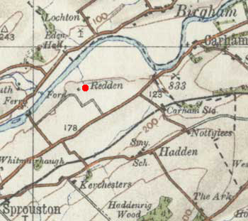 Reddon
is to be identified with the present day farm of Reddon
about 4 miles NE of Kelso and just south of the River
Tweed (see Derek Hall, Scottish Monastic Landscapes, Tempus
Publishing, 2006, page 157). The Hauden mentioned in the
Monastic Annals is the hamlet of Hadden, a mile or so
SE of Reddon rather than Hounam (sometimes Howden), 11
miles to the south. Reddon
is to be identified with the present day farm of Reddon
about 4 miles NE of Kelso and just south of the River
Tweed (see Derek Hall, Scottish Monastic Landscapes, Tempus
Publishing, 2006, page 157). The Hauden mentioned in the
Monastic Annals is the hamlet of Hadden, a mile or so
SE of Reddon rather than Hounam (sometimes Howden), 11
miles to the south.
The journeys to Berwick imply crossing the Tweed, perhaps
at a local ford or at Carham to pick up a road to Berwick
on the north side of the Tweed. To reach Kelso, it may
have been easier to cross near Sprouston but this is not
certain.
Hauden,
or Hadden
A charter of Bernard de Hauden confirmed
earlier grants to the abbey and added:
| |
"eight
acres and a rood, lying contiguous to their property,
on the east side of Hauden, on both sides of the
road to Carram, between Blindewelle, and
another spring next the acre called Croc."
(Monastic Annals) |
Origines Parochiales
Scotiae, Vol. I, page
440; Monastic Annals, page
114/5; Liber Kelso, charter
217, page 178
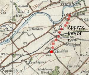 Hadden
is the present day hamlet of Hadden, 4 miles ENE of
Kelso. Although the Blindewelle and Croc cannot now
be identified, Carram must be Carham one and a half
miles to the north. Hadden
is the present day hamlet of Hadden, 4 miles ENE of
Kelso. Although the Blindewelle and Croc cannot now
be identified, Carram must be Carham one and a half
miles to the north.
One would imagine a relatively
straight road to Carham where the Tweed could be crossed
and very probably give access to a road to Berwick on
the north side of the Tweed.
Sprouston
In a charter of Malcolm IV dated
1159 there is a mention of Prestre-bridge.
Monastic Annals,
page
115; Liber Kelso, Charter of Malcolm IV, page
iv
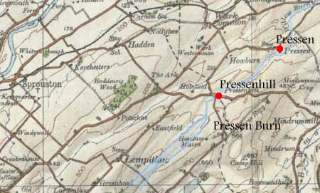 There
is a Pressen Burn that runs in a south-westerly direction
from Pressen down to the English border at Pressenhill
and partly forms the parish boundary of Sprouston. While
it is likely that the Pressen Burn is the Prestre, there
is no certainty that the bridge was at either of these
places. There
is a Pressen Burn that runs in a south-westerly direction
from Pressen down to the English border at Pressenhill
and partly forms the parish boundary of Sprouston. While
it is likely that the Pressen Burn is the Prestre, there
is no certainty that the bridge was at either of these
places.
Shotton
and Colpinhopes
A charter from the time of Alexander
II gave Kelso Abbey:
|
 "5
acres in Schottun in Northumberland, on the west
side of the road, beside the burn which
divides England and Scotland, near Yetholm." "5
acres in Schottun in Northumberland, on the west
side of the road, beside the burn which
divides England and Scotland, near Yetholm."
Two other charters relate to a
grant of Colpinhopes, the boundaries of which
ran:
"from Edredsete to Grengare, under Edredsete,
and to the bridge at the head of the brook,
which divides England from Scotland, and down
this brook, towards the chapel of St Edeldrida
the virgin, to another brook which runs down by
Homeldun, and then up this brook to a glen, where
the brook comes to Homeldun, across the way
which comes from Jetam, and along this way
to the two great stones." (Monastic Annals)
|
Monastic Annals, page
117; Liber Kelso, charter
364, page 292; charter 361, page 288; The
Kingdom of the Scots, G W S Barrow, 1973, page 27&c
; The History
and Antiquities of Roxburghshire and Adjacent Districts,
Alexander Jeffrey, Vol.
III, 1859, page 230ff
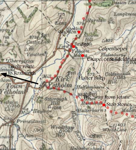 The
present day farm of Shotton lies just over the border
about a mile north of Kirk Yetholm, and there would seem
no reason to doubt that a road ran along this valley much
as today. The
present day farm of Shotton lies just over the border
about a mile north of Kirk Yetholm, and there would seem
no reason to doubt that a road ran along this valley much
as today.
Colpinhopes is more difficult
to identify as some of the placenames are not shown on
early maps, although it was in this general area. Barrow,
in Kingdom of the Scots, shows it just east of Shotton
Hill, (map, page 28). St Edeldrida's chapel is sited a
few hundred metres up the Shotton Burn from where today's
road crosses the border. From the chapel, the boundary
would have gone southwards by the Halter Burn then Shielknowe
Burn under Green Humbleton where there is a path today
leading from Yethholm (Jetam) up to the Stob Stones, which
Jeffrey surmises may be the two great stones (Jeffrey,
page 232).
 |
| Colpenhopes area
(Coldharbour Hill) |
If correct, this is a route that
would allow access into several parts of Northumberland
and certainly Kirknewton and Wooler. Barrow's remarks
about a lost "shire" of Yetholm that may go
back to the 7th century or even earlier are highly interesting.
This shire, which included Shotton, consisted of 12 vills
and was one of 6 estates in Bernicia (Northumberland and
Lothian) gifted by King Oswy to either Holy Island or
Melrose (the precursor of the mediaeval monastery) in
655AD. In principle, this offers the possibility of reconstructing
the routes that existed in this "shire", and
others noted by Barrow (see also Early
Mediaeval Glendale on Northumberland National Park
website).
Molle
Four abbeys, Kelso, Melrose, Paisley
and Jedburgh, held lands in Moll. The charters for the
first three of these refer to roads and fords and are
listed below.

1. Kelso Abbey
Eschina de Londoniis, wife of Henry
of Molle gave a charter of confirmation in 1185 of the
church of Molle and of lands. In the charter the land
of Hethou (Elliesheugh) is described thus:
| |
"As
the water descends from the fountain along Bradestrother
between Hethou and Favesyde, and as far as the rivulet
that descends from Westerhethoudene - and so along
that rivulet as far as the passage of the upper
ford of the same rivulet next to Cracg -
and so across Hathoudene eastwards as the crosses
have placed, and the ditches have been made, and
the furrow has been drawn, and the stones have been
set, as far as the rivulet of Esterhathou - and
from the ford of the same rivulet ascending
as the wood and arable land meet above Halreberghe..."
OPS, Vol. I, page 419 |
Origines Parochiales
Scotiae, Vol.I, page
419; Monastic
Annals, page
119; Liber Kelso, charter
175, page 144
Although Hethou may have been Ellieshaugh, the placenames
are so intractable that little can be said of this charter.
Around the same time, Anselm of Molle
granted Kelso
| |
"all
the land and meadow and wood in the territory of
Molle which was on the east side of Ernbrandesden,
namely, from the bounds of the lands of the monks
of Mailros by the direct path as far as Ernbrandesdene
- and so by Ernbrandesdene as far as the ford
of the Bolbent......." OPS, Vol.I, page 419 |
Origines Parochiales
Scotiae, Vol.I, page 419; Monastic
Annals, page
118; Liber Kelso, charter
154, page 123
Again, the placenames are difficult.
However, there were fords over the Bolbent (Bowmont Water)
at Mow itself and downstream at the church.
Uctred of Molle granted Kelso the
church of Molle with some adjacent land which had these
boundaries:
 |
"namely, from
Hulaueshou (Elliesheugh) as far as its rivulet,
and from there by Hulaueshou as far as the ford
of Bolebent, opposite the church, and from
that ford upwards as far as Hulaueshou, and from
there by the road as far as Hunedune, and
from there to the head of the Hulaueshou."
Scilicet, ab Hulaueshou usque ad rivum ejus,
et a rivo per Hulaueshou usque ad vadum Bolebent,
contra ecclesiam, et a vado illo, sursum versus,
usque ad Hulaueshou, et inde per via usque ad
Hunedune, et inde usque ad capud rivi Hulaueshou.
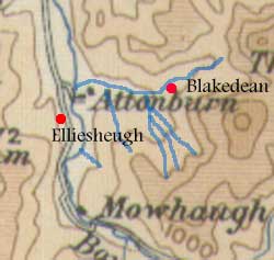
Image:near Molle
(present-day Mowhaugh)
|
Origines Parochiales
Scotiae, Vol.1, page
413; Monastic
Annals, page
118; Liber Kelso, charter
176, page 144
The church is thought to have been
sited about half a mile north of Mow where there was a
ford. As the charter implies, the lands would have extended
from the church to Elliesheugh. The reference to Hunedune
is a bit puzzling if it refers to Howden some three miles
distant although if it meant the road that goes to Howden
it would be much more localised (another charter refers
to there being a road between Moll and Howden and another
to a road north from Moll which could be what this is
referring to). The rivulet
might be the Cote Burn, Holywell Sike or even the stream
above the church on the east side of the Bowmont Water.
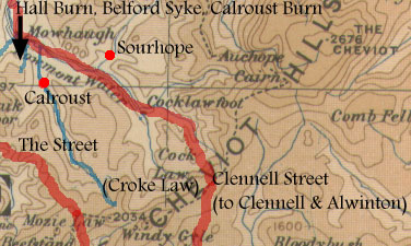
In the mid-1200's Cecilia of Molle
gave Kelso 13 acres of arable land at Mollestele, and:
 |
"that part
of her land which lay next the rivulet descending
from Brademedue as far as the Bolbent, and half
an acre called Crokecroft next the road that led
to Persouth..."
Image: Clennell
Street at Cocklawfoot
|
Origines Parochiales
Scotiae, Vol.1, page
420; Liber
Kelso, charters
148/150, pages 115,119
 JSM
Macdonald (Placenames of Roxburghshire, page 30) says
that Mollestele means "the cattle field at Molle."
It is likely enough that it was in the vicinity of the
settlement. The 1:25000 map shows numerous cultivation
terraces in the area and these together with the mention
of a rivulet running into Bowmont Water suggest that Brademedue
could have been by the Hall Burn, Belford Syke or Calroust
Burn. Persouth does not appear on any of the old maps
but it may have been in the Sourhope area where there
are cultivation terraces. Another possibility is that
Crokecroft relates to the placename Croke Law near where
there are remains of settlements and cultivation terraces
in which case the road could have been up the valley of
the Calroust Burn and Persouth would have been somewhere
in the valley or over the watershed. However, it is more
likely that Persouth (also written as Persouh) is in the
vicinity of Percy Law, one kilometre north of Attonburn,
and the road was therefore a local track (cf. Barrow,
op.cit., page 261). JSM
Macdonald (Placenames of Roxburghshire, page 30) says
that Mollestele means "the cattle field at Molle."
It is likely enough that it was in the vicinity of the
settlement. The 1:25000 map shows numerous cultivation
terraces in the area and these together with the mention
of a rivulet running into Bowmont Water suggest that Brademedue
could have been by the Hall Burn, Belford Syke or Calroust
Burn. Persouth does not appear on any of the old maps
but it may have been in the Sourhope area where there
are cultivation terraces. Another possibility is that
Crokecroft relates to the placename Croke Law near where
there are remains of settlements and cultivation terraces
in which case the road could have been up the valley of
the Calroust Burn and Persouth would have been somewhere
in the valley or over the watershed. However, it is more
likely that Persouth (also written as Persouh) is in the
vicinity of Percy Law, one kilometre north of Attonburn,
and the road was therefore a local track (cf. Barrow,
op.cit., page 261).
Wherever Persouth was, it is clear
enough from the 1:25000 map that there are numerous remains
of settlements and cultivation terraces in the vicinity
of Calroust, Sourhope and Cocklawfoot and it highly likely
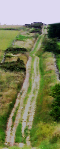
that they were served by tracks. In fact, Clennell Street
passes through Cocklawfoot coming from Alswinton in Northumberland
and is more than likely to be the road that follows the
Bowmont valley. It had an older name of Ernespeth
(see
also) noted in the chartulary of Newminster Abbey
in Northumberland which takes it into Anglian times but
could easily have its origins in prehistoric times. In
later times it was well used as a drove road (see the
RCAHMS Inventory for Roxburghshire, No.376, page 183 for
details of another very old route, The Street, and some
reference to Clennell Street - both tracks started near
Alwinton in Northumberland but had quite distinct courses
a few miles apart).
Melrose Abbey
In the late 1100's Anselm of Wittune
gave Melrose:
 |
"his
whole petary which was between Molope (Mowhaugh)
and Berope and Herdstrete, which separated
the land of Molle from the land of Hunun."
About the same time he granted "the land with
the meadows which he and Glai the nephew of Robert
Avenel with the cellerar and brethren of Melrose
perambulated, namely, as the furrow on the north
side goes from the road which leads from
Hunedune towards Molle, and goes as far as the rock...."
(OPS) |
Origines Parochiales
Scotiae, Vol.1, page
422; Monastic
Annals, page
270; Liber Melros, charter
134, page 126;
Scottish Monastic Landscapes, Derek Hall, page 155
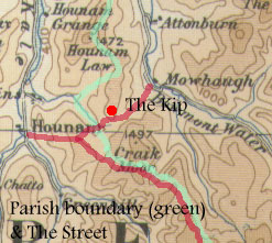 If
Molope is correctly identified as Mowhaugh, Berope is
more likely to be a lost name nearby rather than the Beirhope
four miles west of Mowhaugh. Herdstrete is difficult:
it might be the path running up beside the Hall Burn directly
between Mowhaugh and Hownam although the parish boundary
running at right angles across it at the Howden Burn tells
against this somewhat. It could also be The Street along
which the parish boundary runs though it seems a little
too much to the south (the RCAHMS Inventory suggests this
identification). In any case the fact that the parish
boundary does run along The Street indicates that it existed
at that time and the other reference to the road between
Hunedune and Molle is very likely to be on the line of
the present day track running up the Hall Burn (see the
RCAHMS Inventory for Roxburghshire, No.376, page 183 for
details of The Street). If
Molope is correctly identified as Mowhaugh, Berope is
more likely to be a lost name nearby rather than the Beirhope
four miles west of Mowhaugh. Herdstrete is difficult:
it might be the path running up beside the Hall Burn directly
between Mowhaugh and Hownam although the parish boundary
running at right angles across it at the Howden Burn tells
against this somewhat. It could also be The Street along
which the parish boundary runs though it seems a little
too much to the south (the RCAHMS Inventory suggests this
identification). In any case the fact that the parish
boundary does run along The Street indicates that it existed
at that time and the other reference to the road between
Hunedune and Molle is very likely to be on the line of
the present day track running up the Hall Burn (see the
RCAHMS Inventory for Roxburghshire, No.376, page 183 for
details of The Street).
Anselm also granted Melrose some
land that was adjacent to their land near Howden Law:
| |
"that
portion of land in the territory of Molle which
was next their land on the south of the hill of
Hunedune, and on the east bounded by the road from
that hill to Molle, which road lay between the foresaid
land and the church-lands of Molle, as far as a
fountain on the west side of Kippemoder, as far
as certain large stones of the old building, which
stood upon a small ridge on the south side of the
land called Cruche. Afterwards, the boundary descended
along the same ridge to the south side of the same
Cruche, as far as the rivulet between the lands
of Hunum and Molle.' (Jeffrey) |
The History and Antiquities
of Roxburghshire and Adjacent Districts,
Alexander Jeffrey, Vol.III,
page 278
Liber Melros,
charter
137, page 128
Jeffrey identifies the hill of Hunedune as Hownam Law.
If correct this suggests that the road allowed access
between Moll and the lands to the south of the hill.
Paisley Abbey
In the late 1100's Eschina of Molle,
wife of Walter, the son of Alan the Steward gave Paisley
a ploughgate in Blachedane in the territory of Molle.
The boundaries were:
 |
"From
where the Stelnburn falls into the Blakburne, and
by the Blakburne upwards to the two stones lying
by the bank of the Blakburne, and opposite the house
of Ulfi the steward, on the west part, and so upwards
to a ditch, and to two standing stones in that ditch,
and from these stones to another ditch filled with
stones, and from that ditch to Heselensahe (Elliesheugh),
and from that by the footpath under Heselensahe
to the shallow at the waterfall of Alernbarhe, and
from thence to the ford of the Steinburn,
and so by the Stelnburn till it descends to the
Blakburne." (Lees, page 46)
Image:Blakedean |
The
Abbey of Paisley from its Foundation to Its Dissolution,
J Cameron Lees, Paisley 1878, page 46
Origines Parochiales Scotiae, Vol.1, page
426; Registrum
de Passelet, page 75
 Fortunately
Blachedane has survived as Blakedean, a mile or so north
of Mow. It is likely enough that the Blakeburne is Atton
Burn. Although it is not clear which of the streams
shown on maps running into the Atton Burn is the Steinburn,
the wording of the charter suggests the ford was on
a local route only, perhaps to Molle itself. Fortunately
Blachedane has survived as Blakedean, a mile or so north
of Mow. It is likely enough that the Blakeburne is Atton
Burn. Although it is not clear which of the streams
shown on maps running into the Atton Burn is the Steinburn,
the wording of the charter suggests the ford was on
a local route only, perhaps to Molle itself.
Primside
near Moll
A charter of Gaufrid Ridel, gifting
land to Kelso and dating from about 1180, refers to a
road at Primside which is close to Moll. The charter reads:
| |
"a
whole haugh of the territory of Pronewessete (Primside),
as it lay near the water of Bolbent next the boundary
of Cliftun, on the west side of the road which goes
from Cliftun to Pronewessete, namely, along the
road which goes from the water of Cliftun as far
as the nearest costeria (terrace/wall?) towards
Molle which encloses the whole haugh between it
and the water." (OPS) |
Origines Parochiales
Scotiae, Vol.1, page
405; Monastic Annals, page
121; Liber Kelso, charter
368, pps 294, 295 
The next charter below refers to a road between Molle
and Roxburgh which must have passed through the lands
of Clifton and Primside. It is not certain, however, that
it is the same as that mentioned here, as Clifton and
Primside are a little way off the direct route to Roxburgh.
The mediaeval settlement lay a little way upstream from
present day Clifton. There was a ford at Primsidemill
which may have been used.
Cliftun
near Moll
A grant to Melrose by Walter of Wildeshoures from the
late 12th century of lands in Clifton refers to the road
between Molle and Roxburgh. The charter reads:
| |
"
From the two stones projecting from the rock above
the small rush-bed on the east side of Crukehou,
close by where the lands of Prenwensete and the
lands of Grubbheued meet together; along that rush-bed
and the stone lying below it; along a certain ridge,
according to the marches and bounds which he and
Ernald, abbot of Melros, and Symon, the archdeacon,
perambulated, and made as far as the Bireburn, and
thence across the Bireburn in a southern direction
towards Molle, as far as the rock next the road
eastwards, above the Cukoueburn as the Cukoueburn
descends as far as the same great road, namely,
that which leads from Rochesburgh to Molle; and
from thence along that road as far as the
Mereburn, which separates the land of Cliftun from
the land of Molle ; and thence along the Mereburn
to the boundaries of Hunum; and thence as the boundaries
run between the land of Hunum and the land of Cliftun,
as far as the boundaries of Grubbeheued; and thence
along the marches and boundaries which he perambulated
between the lands of Cliftun and the land of Grubbeheued
; and thence above the foresaid Cruikehou, along
the boundaries which he perambulated between the
land of Cliftun and the land of Prenewensete ; and
thence as far as the foresaid two stones on the
rock above the foresaid rush-bed." (Jeffrey) |
The History and Antiquities
of Roxburghshire and Adjacent Districts, Alexander Jeffrey,
Vol.
III, page 301;
Liber Melros, charter
116, page 108
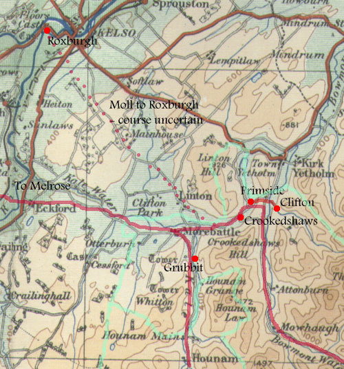 Crukehou
is close to Crookedshaws, Prenwensete is Primrose and
Grubbheud is Grubbit but generally the charter is difficult
to follow because the names of streams have changed. The
map shows some of the named places, the parish boundaries
and some of the roads. However, the mention of the road
is clear enough and presumably ran from Moll up the Bowmont
valley to near Clifton and Primside then across to Roxburgh.
It is not clear if it went directly to Roxburgh from here,
i.e. through Linton, or went over to Eckford. Interestingly
Jeffreys (page 321) says that there was a route between
Melrose and the Cheviot granges that went by Eckford (see
also Jeffrey, Volume
IV, page 188 and Hardie, Roads of Mediaeval Lauderdale,
page 33&ff). Crukehou
is close to Crookedshaws, Prenwensete is Primrose and
Grubbheud is Grubbit but generally the charter is difficult
to follow because the names of streams have changed. The
map shows some of the named places, the parish boundaries
and some of the roads. However, the mention of the road
is clear enough and presumably ran from Moll up the Bowmont
valley to near Clifton and Primside then across to Roxburgh.
It is not clear if it went directly to Roxburgh from here,
i.e. through Linton, or went over to Eckford. Interestingly
Jeffreys (page 321) says that there was a route between
Melrose and the Cheviot granges that went by Eckford (see
also Jeffrey, Volume
IV, page 188 and Hardie, Roads of Mediaeval Lauderdale,
page 33&ff).
Makerston
A charter of Walter Corbet of Makerston
refers to a grant of two acres lying on the north side
of the road from Langtune to Roxburgh, gifted by one of
his vassals, Michael of Malcarvistun to Kelso Abbey.
Monastic Annals,
page
124; Liber Kelso, charter
237, page 193
It is not clear if Langtune is the Langton near Duns,
or the one near Jedburgh, or even a now lost placename
near Makerston (4 miles SW of Kelso) itself.
Hermitage,
Liddesdale
William de Bolebech made a gift to
Kelso of the Hermitage called Merchingleye, in the waste
by the Merching-burn, along with the church of St Mary.
He stipulated that the hermitage should be held by two
of the monks of Kelso.
Eustace de Baliol gave 26 acres of land near Heleychestres
to the Hermitage.
Monastic Annals, page
125; Liber Kelso, charters
265, 266, pages 220-222
This is noted as it can be assumed
that journeys were made between the Hermitage and Kelso.
Jedburgh had been granted the church.
Hownam
William de Hunum gave Melrose land
that extended:
| |
"from
the rivulet of Cuithenop (Capehope) the whole way
up to the ditch between Raweshawe and Cuithbritishope,
and thence by the whole boundary between him and
Richard de Umphravill, as far as Derestrete
(the Roman road) towards the west, and from Derestrete
descending all the way to the march of Chatthou,
and thence by the march between him and Chatthou,
as far as the burn of Cuithenop." (OPS) |
Originales Parochiales
Scotiae, Vol.1, page
394; Liber Melros, charter
131, page 122
 As
the course of Dere Street (noted here as Watling Street)
is known, we need not be concerned with the details of
the charter. As
the course of Dere Street (noted here as Watling Street)
is known, we need not be concerned with the details of
the charter.
Grubbeshead
In the late 1100's,
Uchtred of Grubbeshead, allowed Melrose the right to pass
freely with their carriages from the grange at Hownam
across his lands of Grubbeshead.
Origines parochiales Scotiae, Vol.1,
page
412; Liber Melros, charter
118, page 110; Scottish Monastic Landscapes, Derek
Hall, page 155
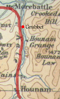 Grubbeshead
is marked on early maps as Grubet a mile or so SSE of
Morebattle, and less than a mile north of the grange. Grubbeshead
is marked on early maps as Grubet a mile or so SSE of
Morebattle, and less than a mile north of the grange.
The charter indicates that there was a track from
the grange, and no doubt, Hownam, to the Morebattle area.
As said, a route continued to Melrose Abbey through Eckford.
Rashawe
John de Laundeles,
who lived about 1245, confirmed the grant made by his
father, or uncle, William, to the monks of Melrose, and
granted free passage to them between their grange at Hunedune
and Rasawe.
The History and
Antiquities of Roxburghshire and Adjacent Districts, Alexander
Jeffrey, Vol.III,
page 311; Liber Melros, charter
279, page 247
The grange was sited a couple of
miles north of Hownam. Rasawe may have been in the vicinity
of Raeshaw Fell, six miles south of the grange. The implication
is that a route ran the whole length of the valley to
Morebattle from where it continued to Melrose by Eckford.
Fairnington
About the year 1200 Richard Burnard of Fairingdun, gave
Melrose "thirteen acres and a rood of his land in
the territory of Faringdun, those namely which lay nearest
the land of Simon of Farburne on the east side below the
King's road leading to Rokesburc." They were
also granted part of a petary and allowed free passage
to and from the petary (OPS).
OPS, volume I, page
494; Monastic Annals, page
270; Liber Melros Charters
86, 87, pages 75,76; The
History and Antiquities of Roxburghshire and Adjacent
Districts, Alexander Jeffrey, Vol.
III, p170; Roads
of Mediaeval Lauderdale, Hardie,
page 36
Interpretation
When this is read in connection with the Maxton charters
below, it is clear that it is the King's highway between
Roxburgh and Annandale which formed the boundary between
Fairnington and Mackuston (Maxton), and is shown today
as the boundary between the parishes of Maxton and Roxburgh.
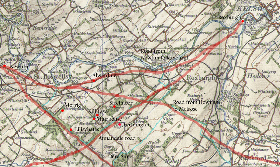
Maxton
Several roads are mentioned in these charters, viz: Derestreet,
the road from Eckford to Melrose (coming from Hownam in
the Cheviots), a road running to the east, the King's
Highway between Roxburgh and Annandale, a road between
Newtun and Roxburgh and a road forming the parish boundary
between Maxton and Faringdon.

Derestrete
In the reign of William the Lion, Robert de Berkeley and
Cecilia his wife granted Melrose part of their land of
Morhus or Muirhouse, amounting to a ploughgate. The boundaries
ran as follows:
| |
"On
the east side of Derestrete from the middle
of the ridge of Morrig southwards, on the east side
of the same strete (strata) as far as the first
sike on the north of Lilisyhates, between Gretkerigge
and Lilisyhates (Lilliardsedge), and so eastward
along the same sike as far as the place which he
(Robert de Berkeley) had assigned to the monks in
presence of his men; and in testimony of which they
had themselves erected a great stone in Morric,
and thence westwards as far as Derestrete.."
(OPS). |
They
were also allowed to use the common pasture of Morhus
for sheep, cattle, horses and pigs and to obtain turf
and heath for fuel, and to take stone from Robert's quarry
at Alwerdine "sufficient to erect the buildings of
the house of Melros."
Monastic Annals, page
270; Liber Melros Charters 90
& 91, pages 78, 79; Roads
of Mediaeval Lauderdale, Hardie
page 31; OPS, Volume I, page
299
Interpretation
As the course of Dere Street is known, the charter need
not concern us too much but Morrig survives in the placename
Morridgehall, and Lilisyhates in Lilliardsedge.
Alwerdine is unlikely to be the Allerdean
south-west of Berwick as it is too far from Melrose. The
more likely location is in the location of Littledean
or Broomhouse, one mile east of Maxton, where there is
a quarry, and in fact Jeffrey (vol. iv, page 196) refers
to the local tradition that building stones for the abbey
came from this locality.
Eckford to Melrose;
a road heading east; a causeway that forms the boundary
between Maxton and Faringdun
Also in the time of William the Lion, Melrose exchanged
this land with Hugo de Normanville and his wife, for some
land to the east of it. The new land was Keluesete and
Fawelawe, probably to be identified with present Muirhouselaw.
The boundaries ran:
| |
"From
the uncultivated ground direct to the ditch on the
north of Kelfsete, and so along that ditch eastward,
and along the march-stones to the road which
comes from Eckeforde towards Melros, and so from
that road along the path across Celfesetestele southwards
by the march-stones there as far as another ditch
on the south of Kelfsetestele, and so along that
ditch to the road which goes thence towards the
east, and so by that road as far as the march-stones
placed cornerwise extending to Fawelaweleche, and
so along that sike (or leche) eastward as far as
the ditch which is the boundary between the land
of Mackestun and the land of Ruderforde, and by
that boundary south-westward to the road which
comes from Eckeforde, and so across that road
westward along the march-stones between the cultivated
land and the moor, and so making a circuit along
the march-stones southward, and thence eastward
to the bounds of the land of Ruderford, and along
that boundary as far as the causeway (or strete)
which is the boundary between Mackustun and Faringdun,
and along that causeway westward to the march-stones,
and thence across northwards by the march-stones
to a sike, and by that sike and the march-stones
there as far as the spot where the perambulation
began." (OPS) |
OPS, Volume I, page
300; Roads
of Mediaeval Lauderdale, Hardie,
page 33; Liber Melros Charter
92, page 79; Alexander
Jeffrey, Volume
4, chapter V
Interpretation
At first sight it seems
a very promising charter but it proves difficult to
follow the boundaries given in the charter. Ultimately,
however, we can gain a good idea of the course taken
by the three roads referred to.
As Hardie suggests, Kill Law (see 6" OS map - Roxburghshire,
sheet XIV) and Steelmoor, both north-east of Muirhouselaw
may echo Kelfsete and Celfesetestele - they are in the
right area as the charter has the heading "of Muirhouse"
and "seat" and "law" are terms used
of hills.
If this is correct we can note that the Eckford to Melrose
road must have ran past the eastern side of Steelmoor
Plantation on a direct route to Maxton. In view of this,
Hardie's routing of it by the Duke's Strip and the reported
remnants of a road heading from the end of the strip
towards Rutherford Burnside may be too far to the east.
The charter's wording for the
"road that goes to the east" is ambiguous.
Hardie suggests the road is identical to the Newtun
to Roxburgh road below, a road that ran south of the
Tweed. This accords quite well with the mention of Rutherford
and with the possibility that the use of "via"
for the "road that goes to the east" and "stratam"
for the Annandale road was intended to differentiate
between them; that is, that the road to the east could
not have been the Annandale road.
Against this, the position in
the charter to the reference to the "road that
goes to the east" implies that it was south of
Kelfsetestele and so could
have been the Annandale road.
That aside, it doesn't matter
too much as there seem to be only the three roads referred
to in the charter; the Newtun to Roxburgh road, the
Annandale to Roxburgh road which forms the parish boundary
between Mackustun (Maxton parish) and Faringdun (Fairnington
in Roxburgh parish), and the Eckford to Melrose road.
The position of each road is known
approximately. The Newtun to Roxburgh road probably ran
about half a mile to a mile south of the Tweed; the Annandale
road is given by the parish boundary; and the Eckford
road (ultimately from Hownam) running towards the eastern
side of Steelmoor, near where it would cross the Annandale
road, and making directly for Maxton and then Melrose.
Dere Street and Annandale
to Roxburgh road
In 1226, John de Normanville, son of Hugh gave Melrose
some land that ran:
| |
"along
the ditch below Kelwelaue as far as Keluesetescloch,
and so descending by Keluesetescloch to the ditch
of Grenrig, and so by the same ditch to Lillesetheburne,
and so ascending by the same burn to the ditch of
Grenerig, and by that ditch westward to Derstret,
and so southward along Derstret as far as the King�s
way from Anandale to Roxburgh, and so along
that way as far as the bounds between Faringdun
and the land of the monks.� (OPS). |
Liber Melros Charter
244, page 219; The
History and Antiquities of Roxburghshire and Adjacent
Districts, Alexander Jeffrey,
Volume
4, chapter V; Roads of Mediaeval Lauderdale, Hardie;
OPS, Volume I, page 300
As noted above, this road forms the parish boundary between
Maxton and Roxburgh parishes, near Fairnington.
Although we will deal with the Annandale road elsewhere,
it is interesting to read Hardie on its course outwith
this parish, and Richmond
(A New Roman Mountain Road in Dumfriesshire and Roxburghshire,
PSAS, Vol.80, 1945-46) and Graham
(The Roman Road to Raeburnfoot, PSAS, Vol.82, 1947-48)
on that part of its course that was identical to the Craik
Cross Roman road. The Roman road probably ran down to
join the main northern road near to Lockerbie. The Bruces
(who had been given Annandale) had their stronghold at
Lochmaben, some three or so miles further on.
Newtun to Roxburgh
John de Normanville also gave Melrose some land:
| |
�on
the west side of Grenerig descending by a rivulet
to the road from Newtun to Rokisburg, and
by the same road ascending to the furrow which was
drawn from the monks� land of Morhus southwards*
to the same road, and by the same furrow ascending
by the great march-stones to the said land of Morhus,
with the common pasture and all the other easements
of Stele (probably the Kelfsetestele of a former
charter) (OPS).
* this should be northwards - aquilonem |
Liber Melros Charter
250, page 223; OPS, Volume I, page
300
The charter immediately above suggests that Grenerig was
between Morridgehall and Lilliardsedge. The rivulet would
be the Ploughlands Burn and would meet the road perhaps
a mile or less south-east of Maxton. This would then lie
to the north of Muirhouselaw.
It is not absolutely clear where
Newtun was. Hardie (page 52) suggests it was Newton
St Boswells, where Melrose had a grange. If so, this
road must have merged with the Eckford road near Maxton.
Lilliesleaf
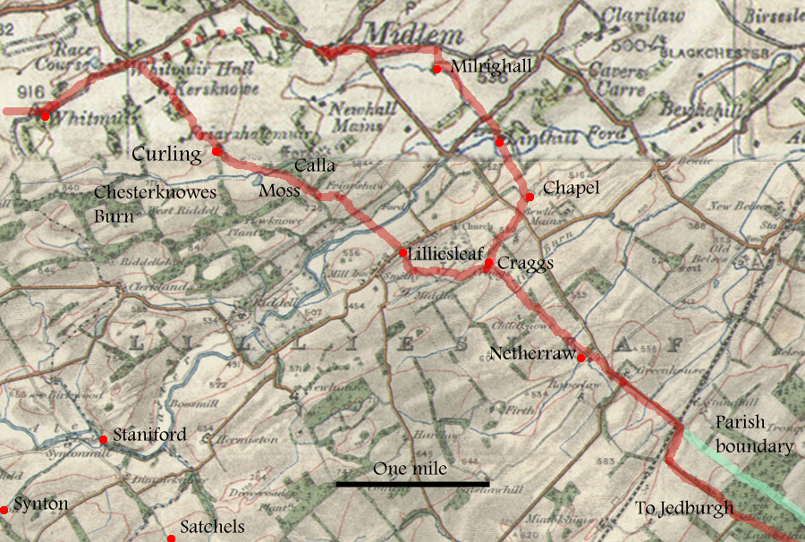
Curlewudeburne ford and Selkirk to Jedburgh road
In the first half of the 13th century, some land in Lilliesleaf
was granted to Melrose, viz:
| |
"From
the ford of Curlewudeburne on the east* side
of Caldelawe along the road which goes from Selkirk
towards Jedewurth as far as the Alne - and so
descending by the same water which is the boundary
between the land of the bishop of Glasgow and my
land as far as the sike which is the boundary between
me and the abbot of Kelcov - and so along the boundary
between me and the same abbot as far as Curlewudeburne�and
so along the same burn as far as the foresaid ford
of Curlewudeburne - with the exception of the land
of William the son of Alexander" - with "pasture
for 12 oxen, 10 cows, 5 horses, and 100 sheep, with
all the other common easements of the same town."
(OPS).
* this should be west - occidentali |
Liber Melros
Charters
282, 283, pp 249,250; Roads
of Mediaeval Lauderdale, Hardie
pps 18,19 ; The
History and Antiquities of Roxburghshire and Adjacent
Districts, Alexander Jeffrey,
Volume
4, chapter VI, page 207, also 167; Monastic Annals,
page
271; OPS, volume I, page
309; Lilliesleaf and
Its Old Roads, Rev. James McKenzie, Trans.
Hawick Archaeological Society,
1947

Jeffrey (vol.iv, page 167) refers to a highway running
by Midlem, Milnrig, Chapel, Hillhead and Greenhouse
and on to the Teviot, but Hardie has the road mentioned
in the charter more to the west of this. His route is
from Midlem practically due south to cross the Curlewude
(now the Chesterknowes Burn in its upper part and the
Shaw Burn in its lower part) and the Alne, into Lilliesleaf.
The further course of the road may be shown by a relatively
straight section of the boundary between Minto and Ancrum
parishes that runs down to the Teviot, and it may have
joined Jeffrey's road at the north end of this parish
boundary.
McKenzie gives a more detailed
and different account of the route. It can be followed
easily on the 6" map (Roxburghshire,
sheet XIII) running from Whitmuir past Whitmuir
Hall where a path leads down to Kersknowe. From there
it went by a still existing track to Curling Farm then
crossed the Curlewude (Chesterknowes Burn) just east
of Greenside Moss, and west of Calla Plantation (which
he suggests is the Caldelawe of the charter) to make
its way to Friarshaw Farm. A path then leads down to
stepping stones on the Ale from where it is a short
distance to Lilliesleaf itself. He makes the interesting
point that the path leads precisely to Bishop's Close
in the village where the Bishops of Glasgow (who had
lands in Lilliesleaf) may have had a tithe barn and
around which the village grew. In general he sees the
route as part of a longer route from Glasgow to Lilliesleaf
and Jedburgh, where Glasgow also had holdings.
South of Lilliesleaf (see sheet
XIV) he continues the road by a short path that meets
a wider road dating from the 18th century and which
he suggests incorporates the mediaeval route. It skirts
Lilliesleaf Moss to pass through East Middles then turns
south-east to Craggs. From there it crosses the Mire
Burn by a substantial bridge and runs down to Netherraw.
Beyond Netherraw he routes it by the present day road
past Greenhouse and Standhill then down through the
Minto Policies (Lambslair Plantation) (sheet XX) to
a ford at Linton Mill. Once over the river it would
have taken a direct line to Jedburgh through Lanton.
It is not clear from his text why he routes it along
the river to Linton Mill when there was a nearby ford
at Spittal and two near Barnhills. The ford at Spittal
would access a direct route to Jedburgh by Ruecastle
and Lanton Hill shown on the Military Survey map. As
already said, there is a possibility that the course
of the road beyond Standhill was along the parish boundary
down to the Teviot although this needs confirmation.
McKenzie also notes the existence
of another old road (the same as that mentioned by Jeffrey)
that went from Whitmuir to Midlem then by Milrighall,
Linthill and Chapel to Craggs where it joined the road
above. He suggests that although still mediaeval it
may have been an easier route for wheeled traffic and
that Midlem itself being a larger village could have
generated some traffic of its own.
In summary then, a road came from
Selkirk through Whitmuir to run directly to Lilliesleaf,
and had its origins in the connection with the Bishops
of Glasgow. It continued SSE to the Teviot and then
to Jedburgh although there is some doubt about the details
of its route on this stretch. Another route went from
Whitmuir through Midlem and joined the other road just
beyond Lilliesleaf and probably developed after the
first route.
Road to moss at Schotteschales;
Staniford
In 1202-8 Florence, bishop elect of Glasgow, granted to
his �man� Alexander of Huntingdon, for the homage and
service of his father and himself, and a yearly payment
of 5 shillings, the land in the territory of Lillisclif
that was called Schotteschales according to its bounds,
viz.,
| |
"between
the burn of Schotteschales and the road leading
to the moss, and as a sike descends from that road
to the foresaid burn on the east side of Schotteschales,
and as another sike descends on the west side of
Schotteschales between the land of Lillisclif and
the land of Sintun as far as Staniford, with the
common pasture and all the common easements of the
whole territory of Lillisclif." (excerpt from
OPS). |
Reg.
Glasg., vol.1, charter 99, page 85; OPS, Volume I,
page
310; Geoffrey Barrow, Scotland and its neighbours
in the Middle Ages, 1992, page
210
Schotteschales is thought to be Satchels, two and a half
miles SW of Lilliesleaf, and Synton a mile further west
in Ashkirk parish. The ford at Syntonmill would fit the
location of Staniford and Barrow's remarks about the possibility
of it being on the line of the Roman road from Craik Cross
towards Newstead are interesting. It could also indicate
an early route between Selkirk and Hawick. The "road
to the moss" may have led uphill to mossy ground
above Satchels.`
Hassenden
When King William and Josceline, bishop of Glasgow were
in disagreement about the church at Hastanden (Hassendean),
the dispute was settled when they agreed to use its assets
for a charitable purpose. These assets were given to Melrose
for use in establishing a "house of hospitality"
for the wayfaring poor and pilgrims making their way to
Melrose.
Monastic Annals, page
272; Liber Melros Charter
121 et seq, page 112
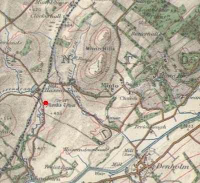 The
monks had their centre at the Monk's Tower, some 200 metres
SE of Hassendean village. Despite the clear reference
to pilgrims and wayfaring poor, and the implication of
a route between (presumably) Hawick and Melrose, it is
not clear what course this route would have taken. Possibilities
would be the Roxburgh to Annandale road and then to Dere
Street although this appears unnecessarily long, or up
to the Lilliesleaf to Jedburgh road and from there to
Melrose. The
monks had their centre at the Monk's Tower, some 200 metres
SE of Hassendean village. Despite the clear reference
to pilgrims and wayfaring poor, and the implication of
a route between (presumably) Hawick and Melrose, it is
not clear what course this route would have taken. Possibilities
would be the Roxburgh to Annandale road and then to Dere
Street although this appears unnecessarily long, or up
to the Lilliesleaf to Jedburgh road and from there to
Melrose.
Ashkirk
In a charter from the reign of William the Lion (1165-1182)
there is a mention of a Staniford in Ashkirk parish (Selkirkshire),
viz
| |
"...from
Staniford to the Cross and from the Cross to the
great Alder tree near the turf ground, and thence
as far as Lilieslade, and thence to the small rivulet
on the east side of the Huntleie, and from that
rivulet to Akermere and so upward to the wenelachia
of Richard Cumin and so thereafter up to the sike
which is next under Todholerig, and so from that
sike to the sike which goes into the rivulet of
Langhope, and from there by the boundary on the
eastside of Lepes between Ashkirk and Whitslade
into the Alne." (OPS) |
Reg.
Glasg., vol.1, charter 30, page 29; OPS, Volume I,
page
314
These boundaries enclose a large part of Ashkirk parish.
While it is not absolutely certain that it is the same
Staniford of the Schotteschales charter it is quite likely,
given that Syntonmill ford is on the parish boundary.
Lessudden
There is a mention
of Dere Street in a Melrose charter where Robert de Londinia
gave them land adjacent to Dere Street. The road is said
to descend obliquely to the east as far as the torrent,
probably the Bowden Burn. Its alignment through the parish
is not known other than it would have made directly for
Newstead fort. Dere Street is also mentioned in a Dryburgh
charter where a grant of Thomas de Londonia included "the
land and meadow west of the church (of "St Mary of Lessedewyn"),
as far as the great road which led towards Eldon."(Jeffrey,
iv, 173) As the location of the church is not known,
it does not help us determine the exact course of the
road..
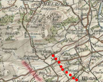
Another road is mentioned in a
Dryburgh charter,
where John, son
of Ylif of Ylifston, gave them "ten acres of land
of his demesne in the town of Yliston, viz., two acres
in toft and croft nearest to and east of the rivulet
which ran below his garden, four acres in Rokflat, next
to and west of the road leading to Boulden, and three
acres in Greenrig."(Jeffrey, iv,
174)
Interpretation
 As
said, neither of the Dere Street references allow us to
determine the exact course of the road. The other road
was in the vicinity of Elliston, two miles south of Newtown
St Boswells and suggests a road ran in a north westerly
direction up to Bowden, one and a half miles distant.
Hardie suggests it would have led to Roxburgh, though
the route seems awkward; a route through Maxton would
be shorter. Jeffrey (iv,
51) has an interesting note on what had been thought
to be a Roman road running past Cauldshiels Hill towards
Bowden but was actually an earthwork raised by David I
to define a boundary between lands given to Kelso and
Melrose abbeys.
This is the "Military
Road" marked on the above map. As
said, neither of the Dere Street references allow us to
determine the exact course of the road. The other road
was in the vicinity of Elliston, two miles south of Newtown
St Boswells and suggests a road ran in a north westerly
direction up to Bowden, one and a half miles distant.
Hardie suggests it would have led to Roxburgh, though
the route seems awkward; a route through Maxton would
be shorter. Jeffrey (iv,
51) has an interesting note on what had been thought
to be a Roman road running past Cauldshiels Hill towards
Bowden but was actually an earthwork raised by David I
to define a boundary between lands given to Kelso and
Melrose abbeys.
This is the "Military
Road" marked on the above map.
Hardie,
Roads of Mediaeval Lauderdale, page 51; Liber Melros,
charter
88, page 76; Liber Dryburgh, Charter 205; The
History and Antiquities of Roxburghshire and Adjacent
Districts, Alexander Jeffrey,
volume
iv, page 174
Bowden
Among the requirements
on those renting land from Kelso Abbey was an obligation
to cart peats from the petary at Gordon to the abbey,
to travel to Berwick with horse-cart, to carry wool from
the grange of Newtun to the abbey and to find carriages
for a journey to Lesmahagow, where Kelso had a priory.
The
History and Antiquities of Roxburghshire and Adjacent
Districts, Alexander Jeffrey,
volume
iv, page 144
Melrose,
South of River Tweed
Dere Street
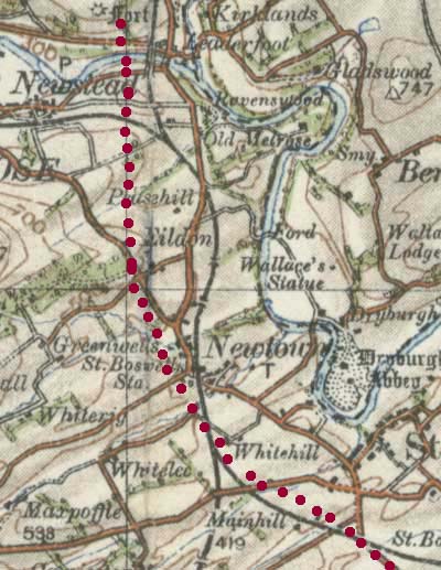 One
important question is the route taken by Dere Street and
where it crossed the Tweed. Chalmers (Caledonia,
Vol 3, page 91) had it cross at a ford near Gattonside
then up to Clackmae, one and a half miles NW of Earlston.
Roy (Military
Antiquities, page 103) routed it from Gattonside up
the valley of the Allan Water but appears to have been
following the Girthgate. One
important question is the route taken by Dere Street and
where it crossed the Tweed. Chalmers (Caledonia,
Vol 3, page 91) had it cross at a ford near Gattonside
then up to Clackmae, one and a half miles NW of Earlston.
Roy (Military
Antiquities, page 103) routed it from Gattonside up
the valley of the Allan Water but appears to have been
following the Girthgate.
Another proposed location was at Newstead and there was
a tradition of there having been a fine stone bridge there
quoted by Milne in his history
of Melrose (1743).
Also, at Red Abbey Stead,
close to Newstead, remains of a twenty foot wide road
running north-south were found.
A paper by J A Smith (Notices
of Various Discoveries of Roman Remains at the Red Abbeystead,
near the Village of Newstead, Roxburghshire, Archaeologica
Scotica, pps. 422-427, Vol.
4, 1857) describes these remains which make it clear
that the road ran just west of Newtown St Boswells, then
close by Eildon village up to the Red Abbey Stead (the
fort of Trimontium is situated here) where it crossed
the Tweed by the bridge.
Melrose,
North of River Tweed
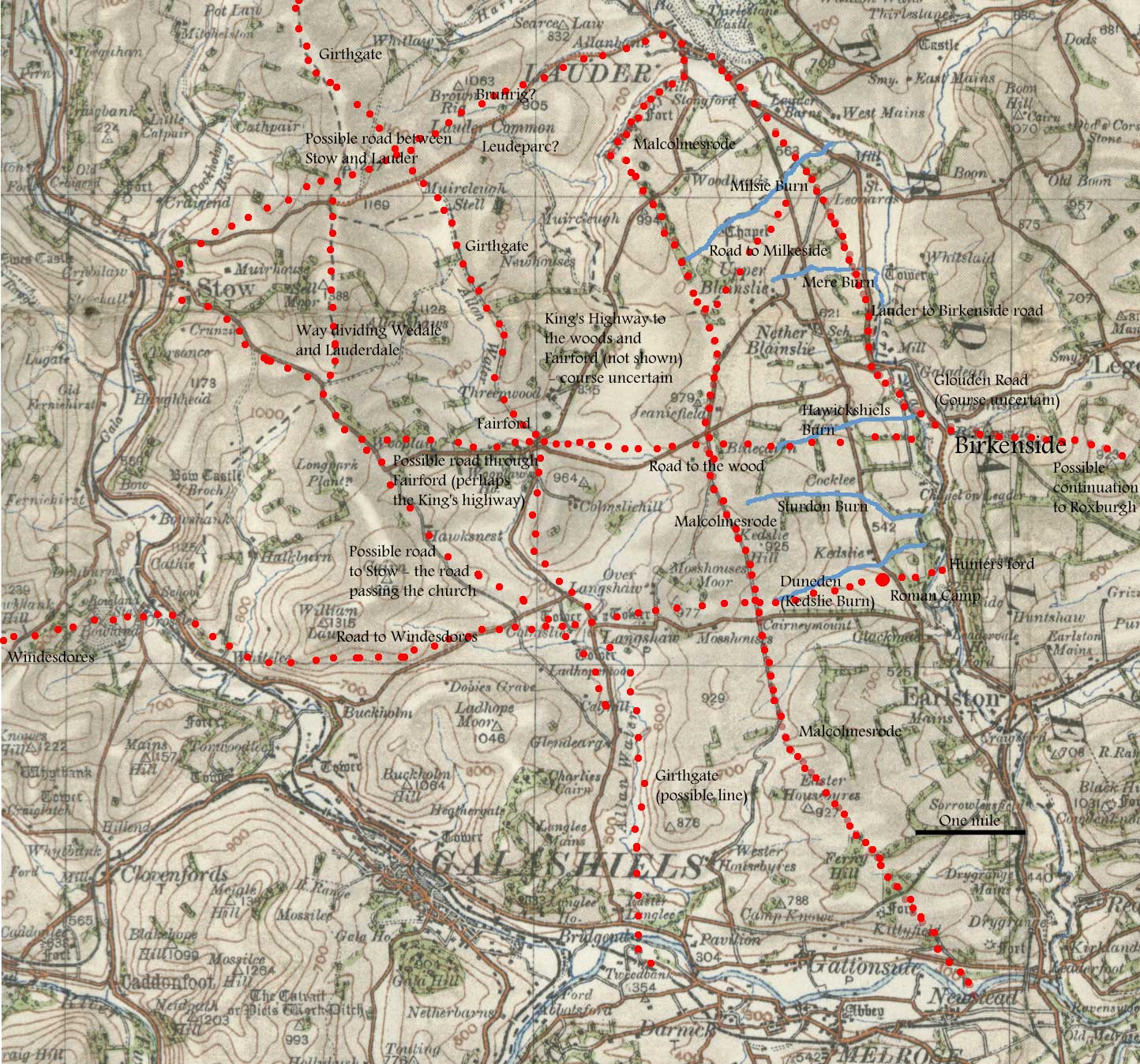
Overview
 |
| Dryburgh
Abbey |
There are mentions of several roads
in the Melrose and Dryburgh abbey charters relating to
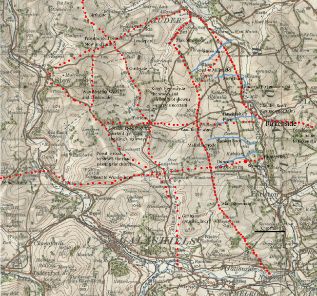
this area. Chief among them was Malcolmesrode which may
have been Dere Street. It ran from near Newstead up to
Lauder, following a ridge of high ground. Two or three
side roads led from this to separate granges near the
Leader on the east side of the road. In the other direction,
one led to Windydoors on the far side of the Gala Water
and one, possibly two, into the forested area in the centre
of the district.
Another main road ran from Lauder to Birkenside and may
have continued to Roxburgh. In the central valley of the
Allan Water there was the Girthgate that led between Melrose
and Soutra, and one other road on the west side of the
Allan that probably ran to Stow. There was also a road
heading north over Sell Moor.
To the north, there may have been a road between Stow
and Lauder.
While some of these roads would have been used mainly
to transport produce to the monasteries, Malcomesrode
and the Birkenside road (if it went to Roxburgh) could
also have been used as long distance routes. The status
of the Girthgate is not certain though it may well have
been used by pilgrims. It is not clear why the Windesdores
road developed.
Introduction
As Hardie (The Roads of Mediaeval
Lauderdale) has dealt so comprehensively with the large
number of charters for this area we will just provide
a short summary of his findings on each of the roads mentioned
in the charters. Excerpts from the relevant charters are
included as his book is now difficult to obtain.
The area was also studied by John
Gilbert (The Monastic Record of a Border Landscape 1136-1236,
Scottish Geographical Magazine, Vol. 99, No. 1, 1983)
who provides a very useful account of how the area developed
and the uses to which each part of the territory were
put. He also provides a map of the routes mentioned in
the charters (see Atlas of Scottish History to 1707, page
455). Also very useful is the account of Dryburgh Abbey
and its properties given in Dryburgh Abbey, Richard Fawcett
and Richard Oram, Tempus 2005 - there is a companion volume
for Melrose Abbey.
 |
| Looking towards
Sorrowlessfield, Kedslie, Blainslie, Milkside etc.
Malcolmesrode generally keeps close to the ridge
line - the lands run from this to the valley of
the Leader in the middle distance. |
To start with, it may be useful to
look at the estates concerned. Overall, Melrose parish
is determined in large part by the mediaeval land divisions.
Apart from a small area south of the Tweed, it is bounded
by the Leader on the east and the Gala Water on the west.
To the north the boundary with Lauder and Stow parishes
runs fairly directly from the Milsie Burn, two miles south
of Lauder across to the Fasseburne, three miles south
of Stow.
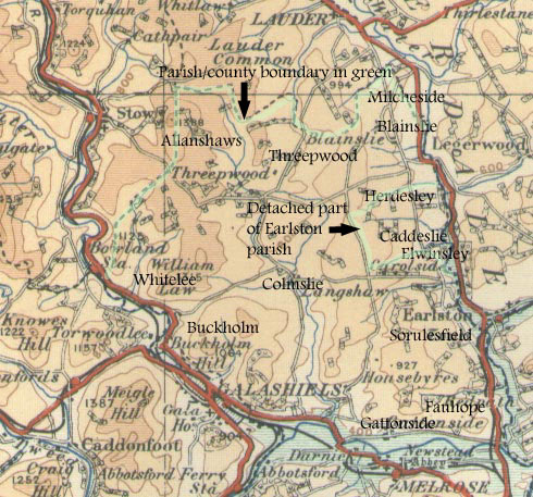 The
various estates can be seen from the map. Apart from Gattonside
and Fauhope immediately north of the Tweed, there is a
cluster bounded by the Leader on the east and, on the
west by a road called Malcolmesrode, that may have been
Dere Street. These are Sorulesfield (Dryburgh), Kedsley
(Dryburgh), Elwinseley and Herdesley (Dryburgh) forming
an outlier of Earlston parish on the west side of the
Leader, and Blainslie and Milkeside (Melrose) just south
of Lauder parish. The
various estates can be seen from the map. Apart from Gattonside
and Fauhope immediately north of the Tweed, there is a
cluster bounded by the Leader on the east and, on the
west by a road called Malcolmesrode, that may have been
Dere Street. These are Sorulesfield (Dryburgh), Kedsley
(Dryburgh), Elwinseley and Herdesley (Dryburgh) forming
an outlier of Earlston parish on the west side of the
Leader, and Blainslie and Milkeside (Melrose) just south
of Lauder parish.
Other roads mentioned are a road between Lauder and Birkenside
which may have continued to Roxburgh, one over to Windesdores
in the valley of the Gala, and at least two others on
an east-west alignment.
In the centre of the territory is the grange of Colmsie
which belonged to Melrose, as well as Threepwood which
was the subject of a dispute between the abbey and Richard
de Morville. North-west of this was Allanshaws and to
the west were Whitelee and Buckholm. Apart
from the Windesdores road heading west through these lands,
there were at least two north-south roads up the valley
of the Allan water, one of them being the Girthgate. There
seems also to have been a road between Stow and Lauder.
Placenames of particular relevance (as identified by Hardie)
are the Fauhope Burn (now Packman's Burn), Scabroeusheud
(cf. Scabbet Hill), Duneden Burn (now Kedslie Burn) and
the Mere Burn (an unnamed burn south of the Milsie Burn.
A hill called Windeslau is just west of Jeanisfield.
Dere Street
and Malcolmesrode
One point of importance is that Hardie identified Malcolmesrode
with Dere Street.
It has to be noted however that the NMRS records (see
for example NT53NE
72) considered this to be mediaeval (referring to
Chalmers Caledonia) suggesting that Dere Street ran closer
to the Leader, passing several Roman camps on the way.
Gilbert also refers to this. Margary in his Roman Roads
of Britain thought that Malcolmesrode was mediaeval though
possibly on an earlier Roman road, having noted some quarry
pits. Whatever
the case, it has the characteristics of a ridgeway which
is suggestive of a very early development.
Chalmers depended on the
observations of his correspondent Kinghorn who surveyed
the remains of Dere Street in 1803 (Chalmers, Caledonia,
v.1,
p.140ff; vol.3,
p.90ff). While old antiquarian reports can
sometimes be confusing, Kinghorn's account must be given
credence if he says the remains of the road were quite
distinct. The course he gives to Dere Street, although
very close to the minor road running up from Drygrange
through Kedslie and Blainslie, is not the same as this
road. The minor road was in fact the turnpike built after
the Turnpike Act of 1768 (see Border Highways, John James
Mackay, 1998, chapter 9) and is shown on Armstrong (1775)
and Taylor & Skinner (1775) but not on the Military
Survey of c.1750.
 |
| Course of Malcolmesrode,
and of Dere Street after Chalmers |
Chalmers, referring to Kinghorn,
routes Dere Street from a ford opposite Melrose up the
west of the Leader, close to the turnpike as far as
a camp called Chesterlee (Kedslie-NT54SE 20) - the road
in this area could easily be seen. It crossed the turnpike
and a small stream that joined the Leader below Chapel
which would place this about 400 metres above today's
Kedslie.
It then ran up to a Roman site called Wass or Walls
at New Blainslie (site NT54SE 18 is 200 metres from
New Blainslie). Kinghorn says that the road was very
evident for a mile and a half north of here when it
crossed the turnpike again, and a nearby stream, half
a mile ENE from Chieldshiels chapel. It then ran towards
Lauder.
Details of the Roman camps (all temporary camps) can
be found on the Canmore
database (Drygrange-NT53NE 33; Kedslie-NT54SE 20;
Blainslie-NT54SE 18; South Blainslie-NT54SW10; St Leonards
Hill-NT54NW 14) - Canmore entries for Dere Street on
this stretch refer mostly to Chalmers. It is interesting
to see that the camps are all on or close to the presumed
line of the road. While this is suggestive evidence
it is not absolutely conclusive. By their nature, temporary
camps indicate the passage of a military unit rather
than a settled base served by roads, although of course
they could use an already existing road. The St Leonards
camp (currently the largest known camp in the Roman
empire) has been dated to the Severan campaign between
208 and 211.
There is another suggestive alignment, which complicates
the issue somewhat. This is that the Blainslie and St
Leonards Hill camps are exactly on the line of the Birkenside
road which forms the county boundary and is mentioned
in charters as a magnam stratam which implies that it
was a made road. The question is whether it is Dere
Street as Kinghorn suggests, or if it is a road to Birkinside
and perhaps Roxburgh as Hardie suggests, though whether
Roman or mediaeval is uncertain.
Clearly this is problematic, but to explore it further
is too speculative given the available evidence.
With regard to Malcolmesrode,
the fact that it is clearly named leads us to assume
that it was either constructed or remade by one of the
Malcolms before the first mention of it in the charters.
Malcolm I (943-954) seems
too early and Malcolm IV (1156-1165) too late. Both
Malcolm II (1005-1034) and Malcolm III (Malcolm Canmore,
1058-1093) are more likely - Lothian passed into Scottish
hands after the Battle of Carham in 1018 and the road
no doubt helped control the new territory and allow
a rapid response in the event of incursions from the
south. As implied above, it has not been determined
whether it had originally been a Roman road, or dated
from early mediaeval times. As said, its ridgeway characteristics
could indicate a very early origin.
The Roads (click map for larger
image)
Several roads are mentioned
although one or two may be the same road under different
names.
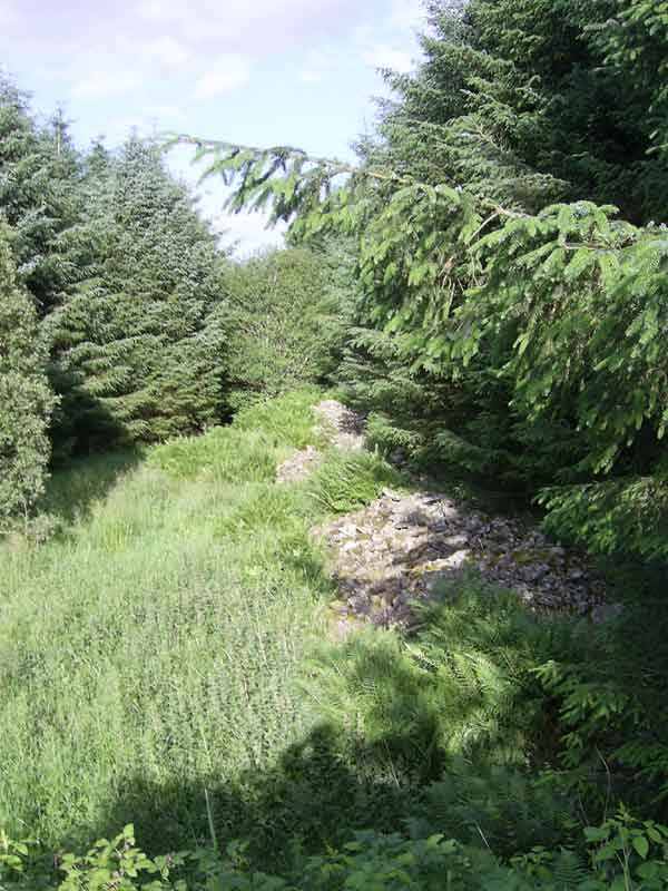
• Malcolmesrode
| |
This
ran on a north-south line from a crossing on the
Tweed near Newstead up to Lauder and formed the
western boundary of several land grants to the monasteries.
|
• Road to
the wood
| |
This
ran through Herdesley (perhaps from Birkenside,
where there was a river crossing) over to Threepwood.
Herdesley was sited between Blainslie and Kedslie
between the Hawickshields and Sturdon Burns. |
• Lauder
to Birkenside (and possibly Roxburgh)
| |
This
appears to have been a major road that ran down
from Lauder to Birkenside on the Leader Water. It
formed a parish/county boundary for part of its
length. Hardie suggests it would have made for Roxburgh. |
• Road
from Malcolmesrode to Milkside
| |
Milkeside
lay north of Blainslie. It may just have been a
local track branching off Malcolmesrode. |
• Road
to Windesdores
| |
This
ran for at least eight miles from near Kedslie to
Colmslie and Whitelee, to cross the Gala Water near
Crosslee. Windydoors was some two miles further
on. In the other direction it may have crossed the
Leader at Hunter's Ford to access Earlston.
|
• Galaden
to Leader
| |
Galadean
(Glouden) lies less than a kilometre north of Birkenside.
As the charter says that the road ran from the south
part of Glouden (presumably near Birkenside), this
could fit Hardie's suggestion that it ran through
Herdesley (opposite Birkenside) and was the same
as the road known as the "road to the wood"
mentioned above. The other possibility is that it
was the same as the Windesdores road, though this
is less likely being about two kilometres south
of Birkenside. |
• Way
dividing Wedale and Lauderdale
| |
This
ran in a northerly direction over Sell Moor, a couple
of miles east of Stow. It may have continued southwards
past Comslie towards the Tweed near Darnick. |
• Way dividing
Burnerig from Laudeparc
| |
This
may indicate a road between Stow and Lauder. |
• The way
towards the south
• King's
highway into the wood and Fairforde
| |
Fairforde
was on the Allan, somewhere near Allanshaws. The
King's highway may have come from Lauder as it seems
too far north to be the "road to the wood,"
although Gilbert identifies it as such. |
• Road leading
from the above
• Road to
the side of the church at Stow
| |
This
may have come up the west side of the Allan from
Darnick, although this is not certain. |
Although these identifications are
not always satisfactory, the fact that there must have
been routes between the granges and the monasteries confirms
some of these routes and suggests others.
Malcolmesrode would have
been of great importance for the Melrose estates between
it and the Leader and we are probably safe to assume side
roads to each grange (although some did exist, the alternative
theory that Dere Street was not Malcolmesrode and that
it ran closer to the Leader and therefore through these
granges has to be taken into account). It would be easier
for the Dryburgh granges to cross the Leader and make
their way south on the east side of the river. Colmslie
and Allanshaws would be better served by routes down the
Allan Water, i.e. the Girthgate and a possible road on
the west side of the river.
Melrose also had lands
at Whitelee and Buckholm which could have used the Windesdores
road. Note: The
references below are to:
• The History
and Antiquities of Roxburghshire and Adjacent Districts,
Alexander Jeffrey
• The
Roads of Mediaeval Lauderdale, R H Hardie
• Origines
Parochiales Scotiae (OPS)
Malcolmesrode
Heading north from the
crossing near Newstead, it would have ran fairly directly
past Kittyfield and near the Fawe Plantation to meet the
track coming up from Easter Housebyres. From here it is
on the course of the Southern Upland Way as far as Fordswell.
Beyond this point is a little uncertain. The fact that
a branch road to Milkeside is mentioned suggests that
it continued on the ridgeway line (SUW) although a more
direct path past Woodheads cannot be discounted.
 |
| Malcolmesrode |
The road is mentioned in several
charters. 1. A Melrose charter
of 1208 relating to a dispute with Patrick, Earl of Dunbar,
viz:
| |
"the
said Patrick had freely granted to the monks the
whole arable land called Sorulesfeld, as held by
William Sorules, west of the Leder towards the grange
of the monks, and pasture for fifty sheep and seven
score cows or oxen within and without the wood everywhere,
between the road going towards Louueder along the
causeway which is called Malcholmisrode and
the Leder, and from the bounds of Cadesley as far
as Fauhopeburne, reserving to the Earl and his heirs
only the right of brushwood."
It was further agreed that neither party should
within these bounds have any houses, sheepcots,
enclosures, lodges, folds, or dwellings of any kind;
that only Sorulesfeld should be arable; and that
the goods (cattle) of the Earl should not pass the
said road, and should every night return to Hercheldune,
unless hindered by storm or flood. The Earl granted
to the monks also the liberty of taking yearly six
score cart loads of peat from the neighbouring moss
of Scabbedraburch. (OPS). |
Sorulesfield,
Liber Melros, charter
101, page 87; Scabbedraburch
- charter 102, page 91; Hardie page 64;
Jeffrey Vol.4,
page 13
Note: Hardie
identifies the Fauhopeburn as the present Packman's Burn.
The road would have ran from the Tweed crossing at Newstead
past the headwaters of this burn to join what is now the
Southern Upland Way. Scabbedraburch must have been in
the vicinity of Scabbet Hill which lies 1km SSE of Easter
Housebyres. Hercheldune is Earlston.
2. A Dryburgh charter for the lands of Elwinsley, which
is the portion of Earlston parish on the west side of
the Leader (the boundary was changed in the 1800's but
see early maps, e.g. Stobie,
NW sheet)
| |
"the
land called Elwinesley and so as the hedge (see
Hardie) goes as far as the Dunedin and so above
as far as Risebrigge and from there by Malcomes
rode to the Strikerden, and by the Strikerden
as far as the Ledre"
terram que dicitur Elwinesley et ita sursum sicut
haya wadit usque ad Duneden et sicut sursum usque
ad Risebrigge et inde per Malcomes rode usque ad
Strikerden et per Strikerden usque ad Ledre |
Liber Dryburgh,
charter
116, page 83; Hardie, page 57
Note: Hardie
suggests the Duneden is the Kedslie Burn. The Sturdon
Burn is suggestive of the Strikerden although the parish
boundary is a little way north of this along the Hawickshiels
Burn. Hardie unravels the difficult references in several
charters to these lands. The (old) parish boundary here
makes it clear that the road is the track used as the
Southern Upland Way.
3. An arrangement between Melrose
and Dryburgh recorded in a Dryburgh Charter (113) that
determined the boundary between Colmslie (Melrose) and
Kedslie (Dryburgh).
| |
"furthermore, on the south part of the grange
of these canons, namely Caddesley, the boundary
will be that road from the southern part
of Glouden as the same road tends to the
Ledre (Leader) and on the other hand to the road
which leads to Lauder - the monks of Melrose are
to have the south and the canons of Dryburgh the
northern part. In like manner on the west of the
aforesaid grange, the boundary will be that road
which leads to Lauder as far as the wood which divides
the plain called Cumbesley from a certain other
plain which is to go to the brethren of Dryburgh;
Cumbesley along with the wood, the brothers cede
to Melrose. Furthermore, the
canons of Dryburgh are to have from
the eastern side of the aforesaid road as
far as the aforesaid plain, while the monks of Melrose
will have the western part."
porro a parte australi grangie canonicorum eorundem
scilicet Caddesley meta erit via illa que est ex
australi parte Glouden sicut ipsa via tendit ad
Ledre et ex altera parte ad viam que ducit Lauder
- monachi de Melross habebunt ex australi parte
canonichi vero de Driburgh ex aquilonali a parte.
Itidem occidentali predicte grangie meta erit via
illa que ducit ad Lauder usque ad silvam que dividit
planitiem que dicitur Cumbesley ab alia quadam planitie
que planicies fratribus de Driburgh - Cumbesley
vero cum silva fratribus cedet de Melross. Porro
a parte orientali presate vie usque ad premissam
planiciem habebunt canonici de Driburgh a parte
vero occidentali monachi de Melross. |
Liber Dryburgh,
charter
113, page 80; Hardie, page 60
Malcolmesrode is the road leading
to Lauder. The Galadean road will be dealt with below.
4. A charter of Richard de Morville
allowing Melrose to cultivate land in Blainsley from:
| |
"Windeslaue,
and from there by the great road which descends
from Windeslaue towards Lauder, as far as the
marches of Lauder." (Monastic Annals). |
Liber Melros, charter
95, page 83; Monastic
Annals, page 263; Hardie, page 71
Note: Using a charter of 1547,
Hardie is able to identify Windeslaue as the summit just
west of Jeaniefield.
5. Another charter of Richard
de Morville (dated from 1188) for Milcheside, just north
of Blainslie, which mentions a road from Lauder to Birkenside
(see below) as well as Malcolmsrode
and a road branching from this to Milcheside (see below).
| |
:as
far as the rivulet called Mereburne, which is the
boundary between the land of Milkeside and the land
of Blainesleie, to the great causeway which descends
from Windeslaue to Lauwder, and thence by the
same causeway northwards to the road which runs
from it to Milckeside, and by that road to the
head of the ditch which we (R. de Moreuille and
Auicia his wife) had begun before we gave the land
of Milkeside to the abbey of Melros, and thence
to the southern head of the ditch which surrounds
the court of the said chapel on the west."
(OPS) |
Liber Melros, charter
108, page 96;
Monastic
Annals, page 263
Note: Hardie identifies the
Mereburne as the stream passing Upper and Middle Blainslie.
Road to the
wood
This is mentioned in a charter of
Walter, son of Alan the Steward
that gave Dryburgh the land of Herdesley which was near
Kedslie grange, where the right to use the road to the
wood was retained. As Hardie says, this was probably Threepwood.
The Leader may have been crossed at Birkenside, which
is opposite Herdesley.
Liber Dryburgh, charter112,
page 80; Hardie, page 59
Lauder to Birkenside (and possibly
Roxburgh); road from Malcolmesrode to Milkside
This road ran from Lauder to Birkenside some 5 miles south
of Lauder. Interestingly the second charter makes it clear
that the parish/county boundary followed this. Hardie
suggests that it went to Roxburgh.
He also suggests that the Milkeside road left Malcolmesrode
about one kilometre north of Fordswell and may have followed
the parish boundary here. The charter context suggests
it was a local track only.
A charter of William, son of Richard de Morville added
to the grant of cultivating land in Blainslie given by
his father. His charter refers to the great causeway
(stratam) which goes from Lauder towards Birkenside.
It is also referred to in a charter of Richard de Morville
(dated from 1188) that gives the boundaries of the lands
of Milcheside thus:
| |
"From the
upper fish-pool, down by the same rivulet which
falls into the said fish-pools, as far as the
great causeway which goes from Loweder towards
Birkenside, and then by the same causeway
southwards to the eastern head of the ditch which
the foresaid monks made
after our assignation between their land and the
land which we have assigned on the south to our
sick, and from the said head of the ditch made
by the monks along the same westwards to the ancient
ditch which crosses the plain from south to north,
and thence southward to the head of the same ancient
ditch, and thence descending obliquely in the
direction in which Joceline lord bishop of Glasgow
and the Cellarer of Melros perambulated the boundary
as far as the rivulet called Mereburne, which
is the boundary between the land of Milkeside
and the land of Blainesleie, to the great causeway
which descends from Windeslaue to Lauwder,
and thence by the same causeway northwards to
the road which runs from it to Milckeside,
and by that road to the head of the ditch which
we (R. de Moreuille and Auicia his wife) had begun
before we gave the land of Milkeside to the abbey
of Melros, and thence to the southern head of
the ditch which surrounds the court of the said
chapel on the west." (OPS)
|
Origines Parochiales
Scotiae, volume 1, page
281, Liber Melros, charter
108, page 96 (also 109); Jeffrey,
volume
iv, page 11; Hardie, page 71, 76
Note: Following
Hardie, this boundary ran from near the chapel at NT 535
451 down by the Milsie Burn to the Birkenside road, the
course of which is shown by the county boundary. It followed
this road southwards for a few hundred yards before making
its way "obliquely" across to meet the Mere
Burn. It then went up the burn to meet Malcolmesrode and
followed this north as far as a road running to Milkeside.
The charter is vague here about the course of Malcolmesrode
but it is probably safe to assume that it had the line
of the present day Southern Upland Way as this continues
to follow the ridge, rather than continuing into the lands
of Blainslie. If this is so, then Hardie may be correct
in saying that the Milkeside road is shown by the county
boundary (or at least part of it). The perambulation is
completed by following a dyke from the side road up to
the chapel.
Road
to Windesdores
 |
| Looking
towards Colmslie |
Hardie takes the road from the
Leader up the Kedslie Burn over to Colmslie and Whitelee,
to cross the Gala Water near Crosslee and reach Windydoors
some two miles further on.
This is mentioned in two Dryburgh
charters relating to Elwinsley which lay adjacent to
Kedsley. Willelmi
de Lyndesay gave Dryburgh:
| |
"the sartum of Alwini from that part of the
water (Leader) that is towards Caddesleya, and from
the top of the same land as far as a certain old
sign of a town and so by the road that leads
to Windesdores..."
...sartum Alwini ex ilia parte aque versus Cadesley
et a capite ejusdem sarti usque ad vetus quoddam
opidi fignum et sic per viam que ducit Windesdores...
|
Liber Dryburgh, charters
110, 111, page 79; Hardie, pages 66, 58
Note: Sartum is ground prepared
for cultivation (see Hardie). The old town may have been
the temporary Roman camp sited at Kedslie - NT 556 400.
It is possible that the Hunter's Ford was used to cross
the Leader - this is mentioned in Dryburgh charter 114
as opposite the Dunenisden (Kedslie Burn).
Galadean
to Leader
Although the second road must be Malcolmesrode, it
is not clear where the Galadean road ran. Hardie suggests
it could have been either the "road to the wood"
or the Windesdores road, though the former is more likely
as it is only a kilometre from Galaden to Birkenside which
is opposite Herdesley where the "road to the wood"
ran.
The Galadean road is mentioned in Dryburgh charter
113 that gives the boundaries between Colmslie and Kedslie:
| |
"furthermore,
on the south part of the grange of these canons,
namely Caddesley, the boundary will be that road
from the southern part of Glouden as the same
road tends to the Ledre (Leader) and on the
other hand to the road which leads to Lauder
- the monks of Melrose are to have the south and
the canons of Dryburgh the northern part. In like
manner on the west of the aforesaid grange, the
boundary will be that road which leads to
Lauder as far as the wood which divides the plain
called Cumbesley from a certain other plain which
is to go to the brethren of Dryburgh; Cumbesley
along with the wood, the brothers cede to Melrose.
Furthermore, the
canons of Dryburgh are to have from
the eastern side of the aforesaid road as
far as the aforesaid plain, while the monks of Melrose
will have the western part."
|
Liber Dryburgh, charter
113, page 80; Hardie,
page 67
Way dividing Wedale and Lauderdale;
way dividing Burnerig
from Laudeparc; the "way towards the south"
In the reign of William
the Lion (1165-1214), Melrose was granted the lands of
Alewentchawis and Threpuude. The bounds of Alewentchawis
(Allanshaws) were:
| |
"From
Fairforde ascending to Staincross, and thence ascending
to the bounds of Wedale, and thence by the way
which divides Weddale from Lauuederdale as far
as Alewentisheude, and thence by the bounds between
Wedale and Lauueder as far as the way which separates
Burnerig from Leudeparc, and along the same
way descending to the stone cross, and thence
transversely to the cross which is situated at the
head of Fulewithenis, and thence by the way towards
the south, near Harlaw, till you come opposite
Morclow, and thence descending by a rivulet to Standenburne,
and thence ascending as far as the boundaries of
Threpuude." (OPS) |
Liber Melros charter
79, page 69, Jeffrey vol
4, page 11; Hardie page 82;
OPS, vol 1, page
281
 |
 |
| Two
views of the Girthgate, just south of Threepwood
Farm |
Note: As
the following charter shows that Fairforde was on the
Allan, the initial part of the description could refer
to the boundary running up to meet the county/parish boundary
near Hareshawhead and the headwaters of the Halk Burn
(Fasseburne).
If so, Hardie would be correct in seeing this part of
the charter as indicating a road (the one dividing Wedale
from Lauderdale) that ran northwards over Sell Moor and
which would reach the headwaters of the Allan.
The east-west stretch of the parish/county boundary would
be the "bounds between Wedale and Lauder" although
the placenames here are difficult.
Leudeparc is suggestive of Lauder Common hereabouts and
there is a Brown Rig nearby which could have been transformed
by metathesis from Burne Rig to Brun Rig - this could
indicate an east-west road here, perhaps between Stow
and Lauder.
The cross at the head of Fulwithenis is
difficult to identify, though given that the Girthgate
forms the county/parish boundary here, it must be the
"way towards the south" where one would turn
in the direction of Muircleugh and run down by the small
stream to the Lauder Burn and then turn south towards
Threepwood.
As the boundary must effectively have finished
where it started, i.e. at Fairforde, it is interesting
to note that the boundary ran to "the boundaries
of Threepwood" and that the following charter says
that Threepwood started at Fairforde. This allows us to
place it on no more than a two kilometre stretch of the
Allan.
Gilbert shows the road over Sell Moor,
then one running along and beyond the northern part of
the county/parish boundary (presumably a Stow- Lauder
road). He shows the Girthgate as
far as the river crossing SW of Threepwood, although he
has the road over to Muircleugh starting higher up the
Girthgate.
King's highway into the wood and Fairforde;
road leading from the above
The description given
fits the county/parish boundary on the north of Melrose
parish, and Hardie gives full details of this.
The charter, from about
1180, concerned the settlement of a dispute between Melrose
and Richard de Moreville over the wood and pasture between
the Gala and Leader. Melrose was given rights of wood
and pasture within these bounds:
 |
| Large
dyke on the county boundary 50 metres east
of Threepwood bridge on the south side of
the burn |
|
"Along
the east side of the river Galhe upwards in the
direction of their own property as far as the
boundaries of Wedale, and also along the right
boundaries of the land of Richard de Moreuille,
viz., as the Mereburne falls into the Leder up
to the source of the same Mereburne, and thence
along the sike which issues from the Mereburne
to the spot where that sike falls into the rivulet
of Standene, and thence as far as Pot, and from
Pot to Standande Stan, and thence as far as the
King�s way where it enters the wood and
divides the wood of Standene and of Threpwude,
and thence by the same King�s way to Fairforde,
and afterwards along that way which goes
to the right as far as the foresaid bounds of
Wedale, and thence by the right bounds of Wedale
to the Galhe."
The wood
of Threpwude was excepted from this although Melrose
was allowed the pasture rights - it was bounded
as follows:
"From Fairforde down by the Aloent to the
moss which is between Threpwude and Cumbesleie
Cnol, and thence by the same moss as far as the
foresaid Pot."
(OPS)
|
Liber Melros, charter
111, page 100;
OPS, volume 1, page
282; Hardie, page
72
Note:
Faireforde must have been on the Allan upstream from
Threepwood Moss (Cumbesleie Cnol must be Colmsiehill).
Given that the Standene was the Lauder Burn (Hardie),
a good fit with the wording would be a road running
west towards Fairford (the King's way), and meeting
a road going to the right, which is presumably the Girthgate.As
the presumption must be that the wording fits the parish/county
boundary, one would follow the Standene down to near
Muircleugh (Morclow) where the Pot would have been,
so that the King's way may have been the straight stretch
of boundary leading to the Girthgate - Fairford would
then have been on the continuation of this line. It
is, however, not clear where this road originated or
where it ended. Gilbert links it to the "road to
the wood" of Dryburgh charter 112 and has it run
over to join a road running up to Stow along the west
side of the Allan. However, it seems too far north to
be the same road, especially as it is said to have divided
the wood of Standen (which seems to be to the north
of Threepwood) and Threepwood. Perhaps it came from
Lauder.
Road to the side of the church at
Stow
This is referred to
in a charter giving the results of an arbitration following
a dispute between Melrose and the men of Stow, viz:
| |
"That
the King�s forest, which was the pasture of the
monks, extended to the road leading to the west
side of the church of Wedale, and as far as
the rivulet called Fasseburne, and should be theirs
so that no one should share it with them."
(OPS) |
Liber Melros,
charter
112, page 103;
OPS,
volume 1, page
282; Hardie,
page 63
Note:
There is not enough information here to determine the
course of this road, other than that it seems to have
come from the south or south-east. Both
Hardie and Gilbert have a road coming from the south-east,
more or less on the west of the Allan Water.
Top
|