|
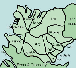
| Assynt
V16, P163 |
Golspie
V9, P26 |
| Clyne
V10, P298 |
Kildonan
V3, P405 |
| Creich
V8, P362 |
Lairg
V11, P569 |
| Dornoch
V8, P1 |
Loth
V6, P311 |
| Durness
V3, P576 |
Rogart
V3, P563 |
| Edderachillis
V6, P278 |
Tongue
V3, P517 |
| Farr
V3, P538 |
General
Observations |
The opportunity afforded by Google
Books to quote extracts from books on their site has
been taken here, so that the text below is that of the
actual accounts rather than a summary although in one
or two places a summary has been given in italics. The
NSA accounts can be accessed on Google Books here;
the volumes in which the OSA accounts appear are given
above under each parish and can be accessed here.
The maps below are from the 1923
quarter-inch OS Map, sheet 7, with thanks to the Ordnance
Survey.
Additional information about parishes
can be found on the Vision
of Britain site and on Scotland's
Places.
Overview
The
Sutherland accounts have considerable information about
roads and this is supplemented by the surveys of farms
in Assynt and on the east coast of the county which
allow a quite detailed picture of the road network of
the time.
At
the time of the OSA, there were some main roads though
these were in bad condition and poorly served by bridges,
dangerous fords and some ferries. There was a road up
the east coast which appears on the Military Survey
map of c.1750 and in greater detail on John Kirk's plans
of farms in Golspie and Loth parishes.
There
was also a road from Tain and Dornoch towards Assynt
which seems to have been made as far as Strath Oykel
and was only a beaten track beyond that. In Assynt itself,
there were basic tracks between settlements which are
shown on the map below and mentioned in the account
of the parish. In Kildonan parish there were three tracks,
one of which - the Crasg - was well used with the two
others requiring a guide. The Crasg was a short cut
of a few miles that led directly north from near Loth
over to Strath Kildonan and the other tracks led north
to Halladale and Strathnaver. Statute labour was applied
in a desultory way, if at all, and usually resented
although the entry for Tongue refers to the enthusiasm
with which road making was being carried out.
There
are mentions of droving, and of cattle being forced
to swim in places; the account for Clyne refers to cases
of fraud that had caused great hardship.
There
were bridges at Brora and in Farr parish in a poor state
and fords, often dangerous, on the way to Assynt, at
Helmsdale, and in Loth parish.
There were several ferries - at Dornoch,
Helmsdale and in Creich parish as well as mentions of
small cobbles. It
is not clear if the Kylescu ferry was in operation at
the time - the Assynt account says no and the Edderachilis
account (on the north side) says it was.
The
contrast with the 1830's when the NSA was written was
remarkable due to the work of the Commission for Highland
Roads and Bridges and the county. Roads mentioned are
from Strath Oykel (ultimately connecting to Bonar Bridge,
Tain, Dornoch etc) to Stoer with some others in Assynt;
Bonar Bridge to Lairg and Tongue; the coastal route
to the north (the Ord was now easily negotiated); Durness
to Altnaharra where it joined the road between Tongue
and Lairg; Durness to Cape Wrath where there was a lighthouse;
Durness along the north coast to Caithness; Helmsdale
through the Strath of Kildonan to the north coast at
Bigfoot near Melvich; and from the coast road to the
north up Strathfleet to join the Bonar Bridge to Lairg
road. The new and improved bridges replaced many of
the fords and ferries; with in some cases, remaining
ferries themselves being improved. The Golspie account
mentions that the Little Ferry was superseded by an
earthen mound 995 yards in length with a short bridge
at one end. Transport generally was greatly improved
as roads were now capable of taking carriages and carts.
For the first time, many places were in easy reach of
the postal service.
Other
Sources
Guide
to the highlands and islands of Scotland, including
Orkney and Zetland, George & Peter Anderson, 1851
Use contents page to navigate to desired area - gives
some details of the roads
Roads
in 1859
This links to the 1859 Report of the Commissioners for
Inquiring into Matters relating to Public Roads in Scotland
and gives an overview of roads in Sutherland at that
time.
Commission
for Highland Roads and Bridges
The annual reports, which can be found on the Am Baile
site, give considerable details of the roads
in the early 1800's.
Geograph
Photos of areas of interest can easily be accessed through
the Geograph site.
Assynt
OSA
Situation�This
parish is situated on the W. N. W. coast of Scotland,
within the county of Sutherland.... The distance betwixt
Thurso and Dornoch is 43 computed miles; thence to Assint
30 miles like measure, at least. Three rivers, and several
considerable rivulets, intersect the road betwixt Assint
and Dornoch; therefore, when the weather turns out rainy,
and continues for but 24 hours, or thereby, the very
rivulets, and especially the rivers, are so many tremendous
torrents, not to be forded, and when rashly attempted,
the consequence seldom fails to prove fatal; along these
30 miles, there is not one bridge, nor but one or two
small boats, of the shape or figure of salmon cobles,
in which a stranger would think himself not safe, far
less would he think of having his horse wafted in them,
though both are often done by the adventurous natives.
The road from Assint to Dornoch, making only allowance
for the preceding hazardous inconveniencies, is in a
tolerable degree opened up, excepting five miles in
Finevin, the property of the late active and gallant
Sir John Ross of Balnagown, whom the narrator has often
heard say, that he would soon drive his carriage to
Kan-loch-elsh (Loch Ailsh, 5 miles east of Ledmore),
which could be easily effected, there being no bog nor
mire in the tract of these few miles, only stones of
such bulk as might be taken up by any ordinary man,
and removed to a distance; the bottom is gravel. Sir
Charles Ross, son and successor to Sir John, would have
only to say, " Let these five miles be opened for a
road;" and it would readily be done.
------------------------------
Between
Loch-me-addy and Fane-loch there is a dangerous ford
called U-y-farn at which some people have drowned.
------------------------------------
The length of this part of the coast (from the river
of Kirk-ag to the point or land end of Row-store), if
the uneven, winding, and in some places, rocky foot
road from farm to farm (Inverkirkag, Baddy-na-ban, Knock-nan-nach,
Culag, Filin-wintering, Drumswordland, and Duchlash)
be followed, may be found at least to measure 15 miles.
----------------------------------------
But, to proceed, (near Lochinver) along a dangerous
wooden bridge to the opposite side of Inver river, in
our way to Row-store-point, several farms and grazings
offer to view, interspersed with numberless rocks, stones,
and hollows; however, all have the advantage of fishing.
----------------------------------------
The
writer gives a long description of the "roads"
in the parish and it is interesting to compare these
with the roads shown on Home's maps. He does mention
the track from Inverkirkaig (just south of Lochinver)
to Ledbeg (from where the road continued to Tain and
Dornoch) that ran to the north of Suilven but has another,
not shown on Hume, that ran to the south of Suilven.
He also refers to the route by Loch Assynt over to Inchnadamph
and then south to Ledmore that Home shows in part.
At
Tumore near the western end of Loch Assynt he mentions
the road shown by Home that led ultimately to Oldeny.
His reference to Cromauld, Auld-an-achy, Alpine, and
Knock is simply that the farms were in that area (SW
of Loch Urigil over towards Knockan and Elphin) and
not of any roads to them.
He
does not mention Home's road from Lochinver to Drumbeg
or from Stoer towards Lochinver, nor from Stoer to Drumbeg
or the roads towards Unapool,Tubeg and Elphin.
The
description is as follows:
|
But
to give as clear an idea as possible of the different
tracts and directions in which these places are
situated and found, the narrator will suppose,
that a traveller sets off from Inver-kirk-ag shore
for Ledbeg on the height of this parish ; in this
event he will either keep by the south side of
Su-il-vine, or Suggar-loaf-hill, and find the
path disagreeable, abounding with stones, in some
parts with rocks; and in
case he would wish to give a call, or shelter
himself from rain or storm, there is but one habitable
place called Brackloch, (close by the western
end of the great fresh water lake called Ca-um-loch),
a distant pendicle of Ledbeg-farm.
Or,
again, if the traveller sets out from Tilin-wintering
by Ed-ra-vine track, he will find his way almost
equally bad for said Ledbeg, though in part opened
up several years past. Here also is but one habitation,
named Clo-ich-a-ry, situated in a contracted gloomy
hollow, mostly surrounded with rocks. It lies
to the north side of lofty Su-il-vine. This place
is also a remote corner of Ledbeg farm, and occupied
by a herd of Lieutenant Kenneth Mackenzie, the
tacksman.
But
in preference to both the above tracks, if the
traveller sets off, by Inver and Brackloch-Inver
farms, keeping along the north side of Inver river,
he will find his way more comfortable in every
respect. One hour's walk or thereby will bring
him to Little Assint, and he may walk or ride
as he may find convenient. Little Assint is a
wintering, and consequently a temporary residence
of Lieutenant John Scobie. He generally has a
boat at the western end of the beautiful fresh
water lake called Loch-Assint. If it can be got,
it will serve as a vehicle for seven miles towards
the higher farms here; and then the traveller
lands near the parochial kirk; but though the
boat should not be procured, it makes no great
difference; as upon leaving Little Assint, the
traveller makes for Tumore, where the road becomes
perfectly firm, and continues so, not only to
Auld-an-na-kal-gach, the present march, but as
far further as the length of Dornoch or Tain.
But to proceed and mention all the other farms
of this inland intermediate tract ; the traveller
leaving Tumore (besides this tract or road from
Inver to Tumore, there is another from Oldeny
to it also, at the distance of a half mile from
Tumore, in our way thence for the height, a path
or track strikes off this principal road (as we
call it) by Ballach-lerag for Slishachilith, particularly
for Glenlerag, Ned, and Ardvare farms; the two
former situated by the chops of Loch-Ned, the
latter not far from it, has the high hills of
Cu-i-nag close by him, to the north; on his right
hand is the small winterings of Edra-chalda, at
same time the winterings of Upper and Lower Tubegs
offer to full view; they lie along the south side
of Loch-Assint at the base of a group of hills
called Bine garve. From Baddy-nacarbad, the small
wintering of Edra-chalda, the road leads directly
cross the little, but occasionally rapid river
or burn of Ski-ak, through the farms of Upper
and Lower Achmores, that of Edra-chalda, cross
the small river of Chalda, then through the farm
of Culin and Half Camore; here, about the eastern
end of Loch-Assint, are the parochial kirk and
manse.
The
way thence leads cross the river Tralegal, which,
at a little distance enters Loch-Assint, then
through the farms of Inch-nadaff, Sronchruby,
and Laing, cross A-na-ka-un river, by Ry-an-cro-vich
farm, thence, advancing a little, there is a path
which strikes off for Leadbeg farm-house, but
the public road is continued to Auldan-nakal-gach;
the farms from thence westward (in the direction
of Cloich-glas maul-a-chirn, etc, formerly described),
and lying within that line of march, are Ledmore,
Cromauld, Auld-an-achy, Alpine, and Knock. The
narrator having now faithfully mentioned every
particular farm and inhabited place, the manner
they are situated along shore, and how they lie
in the inland tracks, he leaves the consideration
and decision respecting public roads to the Honourable
Commissioners of the county; only adding, that
if these roads were begun and finished, bridges
built, and regular stages fixed, probably no less
curious and useful object would cast up to view,
and be found here, than in the Swiss Cantons,
so very particularly described by British travellers.
|
Ferries.�There
is no ferry here; the only one that would be necessary,
is one at Unapool of assint, by Kilis-cu-ig to Edrachilish,
or vice versa.
Ale-houses,
Inns, and Police, Etc.�No ale-houses here, nor inns,
except honest tenant's houses, at certain distances
here and there, on the several tracks or roads not cleared
up, where the weary traveller may now get a good, clean,
Highland woollen plaid, and a comfortable pallet or
couch to sleep on. There are no bridges betwixt Assint
and Dornoch, nor one betwixt Assint and Tain, excepting
that called the bridge of Grug-ag, near Kincardine,
Rossshire. If there were bridges, the road is well opened
to Brae of Strath-Okel; but thence to Assint is a very
fatiguing length; no houses; none of accommodation ;
that whole tract to Assint, is a perfect wilderness;
the whole is sheepfarms without stages.
There
are two preaching places, one at Achnahiglash, otherwise
called Kirktown; the other preaching place at Torbreck,
one English mile distant from Loch-Inver. The distance
betwixt Achnahiglash and Torbreck is eight long computed
miles.
Burial
Grounds.�As for burial places, at a considerable
distance one from the other, there are no less than
six. 1st, At Ach-na-hi-glash, or Kirktown; 2d, At Ged-a-vo-lich,
by the west of Loch-Nedd; 3d, At Ardvare, where, as
formerly said, there is plenty of marble under the heather,
which indeed the narrator came accidentally to know
of, as he happened to be travelling alone, and missed
the road-track; 4th, At Oldney Island; 5th, At the farm
of Store; 6th, At Inver farm, near the entry of Inver
river to the harbour of spacious Loch Inver.
By
What Means the Situation of the Inhabitants and Parish
might be meliorated.�By
good roads and decent inns, If a road were opened from
Lairg by Braemore of that parish; thence by Rosehall,Tu-tom-tar-vach,
by Finvin, and Garvachirn, thence to Auld-an-na-kal-gach,
the present march of this parish with Balnagown property;
any person would walk easily enough betwixt Dunrobin
and this parish of a short day. Besides roads carried
on in Assint, and inns built, a few bridges would be
necessary. One store-house, if not two; at Loch-Inver
one ; at Unapool another; the former would be sufficient
to serve the low, the latter to serve the higher parts
of Skish-a-chilish, and inhabitants of the height. The
victual of the Honourable proprietors put up in these
storehouses would prevent the exorbitant prices of importers,
and secure the money to the former.
The
writer notes the great potential for developing the
parish.
NSA
Quarries.�A
marble quarry was opened near the church some 30 years
ago and "roads were formed, or rather tracts for
the heavy waggons, from Ledbeg to Unapool, a distance
of sixteen miles." The project proved too expensive
and was discontinued.
V.�Parochial
Economy. Markets.�There is no market-town within
the parish; neither have any markets been established.
It is intended to establish a cattle market at Inshnadamph.
This would prove very advantageous to the people, and
save them the expense and trouble of driving their cattle
to a greater distance. The Kyle tryst, held in the vicinity
of Bonar Bridge, forty miles beyond Inshnadamph, is
the nearest cattle-market at present (since writing
this a cattle-market has been established, and is likely
to prove a permanent benefit).
Means
of Communication, Etc.�In Lochinver, also, is a
post office. There is another in the immediate neighbourhood
of the church. The mails arrive regularly twice a-week.
This is one of the greatest improvements imaginable.
A letter or newspaper from London we have the fifth
day. In connection with the post office, I am naturally
led to notice our excellent roads. Nothing has so much
contributed to the external improvement of the country
as these, by which this interesting district, till lately
inaccessible, and comparatively unknown, has been opened
up to the public; and thus, advantages secured to the
inhabitants, which our ancestors would have deemed impossible.
This improvement is attributable, in a great measure,
to the Noble proprietors, and, were there no other benefit
conferred on it, Assynt, on this account, owes a lasting
debt of gratitude to the late excellent Duke of Sutherland.
The length of road constructed from Aultnacaelgach to
Store, including branches to Unapool and Inverkirkig,
exceeds forty miles. To this may be added several miles
of bye roads for the exclusive benefit of the tenantry.
There is a small convenient harbour at Lochinver, where
a pier has been erected. There are some other harbours,
or rather creeks, at Nedd, Oldney, and Ardvar, all lying
on the north side of the point of Store, which afford
shelter and anchorage.
-----------------------
Alehouses.�There are several in the parish.
Fuel.�Peats
are universally used, and much difficulty is experienced
in seasoning them, arising from the excessive rains
with which we are often deluged.
John
Home's Survey of Assynt in 1774 (National
Library of Scotland)
Clyne
OSA
Betwixt
400 and 500 black cattle are exported yearly from the
parish, being sold to drovers for the south of Scotland,
and for England. This trade, however, is not yet well
understood or carried on under proper regulations, several
dealers having of late found means, after getting possession
of the cattle, to evade payment of the greatest part of
the price. This has been the source of incredible confusion
and distress for a number of years past, and the inhabitants
of this parish have suffered deeply their own share of
the public calamity. The dependence of the Highland part
of the parish for paying their rent, and supporting their
families, is upon the produce of their stocks and herds.
----------------------------
There
are no bridges worth mentioning, on any of the numerous
burns or rivers in the parish, except one on the river
at Brora, about a furlong above the place where it falls
into the sea on the high road to Caithness and Orkney.
Even this bridge, important as it is to the public, is
in a state of great disrepair. The sea at full tide runs
up in the river far above the bridge; and, at low water,
it is four fathoms deep immediately below it.
NSA
There
was scarcely a cart or a plough among the small tenants
in the parish forty years ago. It can now boast of 258
carts and 240 ploughs, all made by native tradesmen,
on the most approved principles.
----------------------------
V.�Parochial
Economy. Market-Town, �c.�Dornoch
is the nearest market-town, being distant about thirteen
miles from the confines of the parish; but half-yearly
markets are held in Golspie, only four miles distant,
in June and October. Brora is the only village, and
contains 280 inhabitants.
Means
of Communication.�When the former report was published,
there was not a mile of road fit for a carriage, and
Brora could boast of the only bridge in the county.
It has probably long enjoyed this advantage, and its
name may have been derived from the Danish word Brora,
a bridge, or from brugh, a borough.
Now,
the country is intersected in every direction with the
finest roads in the kingdom, there being in this parish
alone about thirty miles of road, and fifteen bridges
of the most perfect construction, and always kept in
the best order. No toll-dues are exacted in this county,�which
is justly prized as a great advantage over our neighbours.
Brora
being a sub-post-office, a neat receiving-house was
built by subscription from the inhabitants, and the
Mail-Coach, drawn by two horses, passes and repasses
daily.
A pier was constructed at the harbour, at the sole expense
of the late Duke of Sutherland, when the coal and salt
works were in operation, and which affords secure shelter
to coasting vessels.
--------------------------------
Markets.�A market is held at Brora in the month
of October, which is attended by the people of this
and the neighbouring parishes. Shopkeepers come from
a distance, and erect tents to display their commodities,
and they usually meet with a ready sale. A great many
cattle and horses change owners, it being the last market
of the season.
There
are five inns.
Fuel.�The
ordinary fuel is peat procured from mosses in the close
neighbourhood, and the fishers collect coke from the
shore under flood-mark. Coal is imported, costing from
16s. to 18s. per ton, and its use among the wealthier
class is much on the increase.
Creich
OSA
The
black cattle are mostly of a small hardy kind, and may
now, at an average, fetch, when sold to drovers, from
2 L. 10 s. to 3L. Sterling.....The people depend principally
on the black cattle for paying their rents.
Ferries
and Roads.�There are no bridges in this parish;
but there are 4 or 5 ferries between it and that of
Kincardine, which are crossed by cobbles, or yawls,
and boats, that can ferry over two horses each, or more.
The people in this parish and neighbourhood, have been
amused from time to time with the hopes, that a bridge
was to be built over the Kyle, at Culrain, about four
miles above the church of Criech, at the expence of
government. It would be of great advantage to the inhabitants
of this district in particular, besides the emolument
that would accrue to the community at large, if the
public road around the ferries were brought this way
by a bridge. Such a bridge would be particularly convenient
for drovers; all the cattle driven to the south from
Sutherland, Caithness, and Lord Reay's country, except
the parish of Assint, having hitherto been obliged to
cross the Kyle by swimming; which, when the weather
is bad, and the Kyle much swelled by rains, hurts the
cattle greatly, especially when the night following
proves cold. Sometimes they refuse to swim, in which
case they must be ferried over by the cobble. The people
pretend to foretell, whether they shall have a good
market or not, by their readiness to swim. The roads,
in this extensive parish, are very bad; statute work
is but seldom performed, which may be owing to this
circumstance, that few heritors reside in it. The roads
might easily be made good, as the bottom is hard and
gravelly.
NSA
Navigation.�Several
vessels trade to Bonar Bridge, of from 30 to 60 tons
burden, importing meal, coals, and lime; and exporting
fir props, wool, oak-bark, corn, and salmon.
V.�Parochial
Economy.
Market-Town and Villages.�There are no market-towns
in the parish, and the nearest is Dornoch.
The
centrical position of Bonar Bridge, situated at the
great entrance of the county, and at the junction of
the Assynt, Reay, Caithness, and Ross-shire roads, has
pointed it out since the erection of the magnificent
iron bridge in 1813, as the site of a future town. Mr
Dempster is feuing ground here, and a village has already
arisen, which is gradually increasing by that slow and
natural growth which experience has shown to be the
most secure foundation of a town. The great Kyle markets,
as they are called, for the sale of the cattle of Sutherland
and Caithness, are now held here, in the months of July,
August, and September. A suitable piece of ground is
inclosed for the purpose, and the convenience of the
public will be greatly promoted by the desertion of
the very inconvenient place at Portenleik, where they
have hitherto been held.
Bonar Bridge is already a place of considerable export
and import, having the advantage of depth of water sufficient
for shipping. There is no village at Newton, but it
is used as a shipping place for the wool, corn, wood,
&c. of this parish.
Means
of Communication.
Bonar Bridge.�The first and most useful among the
means of communication in the parish is the bridge of
Bonar, consisting of one large metal arch and two smaller
stone arches: it opens the communication between Sutherland
and Ross-shires, as well as to the most distant parts
of the country, south and north. It was erected by Government
and the county; as were also the roads leading from
it.
The
first road, from Bonar to Assynt and the west coast,
has three bridges; one of two arches over the river
Shin; one of a single arch over the river Caslie; and
one of a single arch over the river Oykell. This public
road runs through the parish from Bonar to within a
few miles of the manse of Assynt, a distance of about
thirty miles. The second public road from Bonar is by
Lairg to Tongue, at the north coast. The third public
road from Bonar (recently opened) is made through the
middle of the parish in mosses and hills, towards the
Fleet Mound and the east coast of Sutherland. It extends
within the parish a distance of seven miles, and has
a bridge of one arch over a small river. The fourth
public road from Bonar is towards Dornoch and the east
coast. This road within the parish extends a distance
of eight miles, and there are two small bridges upon
it at Spinningdale and Ospisdale. These four roads were
made by Government and the county. There are, besides,
several private roads with bridges through the different
inhabited straths and glens; which render the communication
through the parish both easy and comfortable in all
seasons of the year.
Inns,
Alehouses, Etc.�There is one inn at Bonar, and five
or six alehouses in different parts of the parish; but
the people seldom exceed a necessary refreshment. September
1834.
Dornoch
OSA
 Situation,
Extent, Surface, Soil, Climate, Etc.� The burgh of
Tain in Rossshire, stands on the south side of the frith,
directly opposite to Dornoch; and three computed miles
to the westward of both, where the frith becomes pretty
narrow, is the Meikle Ferry, so called in contradistinction
to another arm of the sea, called the Little Ferry. On
each side of the former, there is a large boat for transporting
carriages, horses, and other cattle; as also a yawl for
the accommodation of foot passengers; but at the Little
Ferry these are found on the east side only. At this ferry,
four hands serve; and the same number at each side of
the Meikle Ferry. Frequent complaints are heard of both;
an evil not peculiar to these ferries, nor likely to be
remedied, until the property and disposal of such be vested
in the public, instead of private proprietors, whose chief
aim, naturally, is to have as high a rent as possible. Situation,
Extent, Surface, Soil, Climate, Etc.� The burgh of
Tain in Rossshire, stands on the south side of the frith,
directly opposite to Dornoch; and three computed miles
to the westward of both, where the frith becomes pretty
narrow, is the Meikle Ferry, so called in contradistinction
to another arm of the sea, called the Little Ferry. On
each side of the former, there is a large boat for transporting
carriages, horses, and other cattle; as also a yawl for
the accommodation of foot passengers; but at the Little
Ferry these are found on the east side only. At this ferry,
four hands serve; and the same number at each side of
the Meikle Ferry. Frequent complaints are heard of both;
an evil not peculiar to these ferries, nor likely to be
remedied, until the property and disposal of such be vested
in the public, instead of private proprietors, whose chief
aim, naturally, is to have as high a rent as possible.
------------------------
Roads
and Bridges.�Nature has made the public roads here
passable: they owe little to industry or police; the statute
labour has occasionally been exacted, but it has not been
applied with that constancy and vigour, which would render
it efficient. A commutation of it appears to be now in
contemplation, among the proprietors of this and some
other northern counties. This parish is destitute of bridges;
the want of one is particularly felt at the river of Evelick
which is often not passable in winter. A piece of ground
in the vicinity of Dornoch, is said to have been destined
by former public spirited proprietor, for the purpose
of upholding a bridge on this river, although it is
uncertain if this will be carried out by the present proprietor.
-----------
The
writer notes the great distance to peat and turfs and
the time wasted in gathering these. Even if roads were
made and carts brought into use, there would still be
problems.
NSA
Mention
of the Meikle Ferry and the Little Ferry - coal ships
discharge their cargo nearby.
Parochial
Economy.
Burgh.�Dornoch is the only market-town in the
parish, and the only Royal Burgh in the county. It was
erected into a royal burgh by a charter from Charles
I. A. D. 1628.
This
is one of five which compose what is called the northern
district of burghs. It has no landed property, nor any
other source of revenue except the customs levied at
six annual fairs held here, and which are on the decline.
But this may be accounted for by the recent establishment
of two other fairs,�one in the village of Golspie, and
another in the parish of Clyne,�and by the great number
of retail-shops found here and there through the parish
and the county.
Dornoch
has a post-office and the mail-coach passes through
twice a day.
The
communication with the town is open in every direction
by excellent roads and bridges, which are kept in annual
repair. The Macadamizing system is adopted on the county
roads. Indeed, the whole parish is intersected with
roads and bridges; and with these there is another great
advantage,�there are no tolls. Not a toll is to be seen
in the county of Sutherland. Hence, carriages, gigs,
and carts may be seen on Sabbath days carrying some
of the good people to church.
Inns,
Etc.�There are inns in Dornoch, Meickle Ferry
and Clashmore.
Fuel.�Coals
imported from Newcastle have been used here by the better
classes in town and country, for the last twenty years
at least. They are purchased at Dornoch, at from Is.
l0d. to 2s. per barrel, and carried home in carts. Peats
are still used by the common people.
September
1834.
Durness
OSA
Roads.�No
roads have yet been made through this tract of country,
and, of consequence, on no occasion has the statute labour
yet been exacted.
----------------------
Fuel.�Peats are the fuel universally used through
the parish. These every family cut and prepare for themselves.
NSA
 |
| Old gas lamp standard |
V.�Parochial
Economy. Means of Communication.�Thurso
is the nearest market-town, 65 miles distant . There
are no villages, the population all residing in hamlets
along the shores, containing
from 4 or 5 to 20 families. The means of communication
have been much improved during the last three years,
by the liberality of the late Duke of Sutherland. Formerly,
the post-office was at Bonar Bridge, a distance of 62
miles, to which there was a runner sent once a-week
at the sole expense of a few subscribers. There is now
a post-office twice a-week to Tongue. The days of dispatch
are Monday and Thursday; of arrival, Tuesday and Friday,�to
suit the Golspie mail, which crosses the interior to
Tongue every Monday and Thursday. There is a weekly
runner to Scowrie. There is also a monthly carrier to
Tain; but almost all imports and exports are by sea.
 |
| Plaque on Rhiconich
to Durness road |
The
roads are, 1st, a
road from the Kyle of Durness to Cape Wrath (capewrath.org.uk),
executed by the Light-house Commissioners in 1828, 11
miles in length; 2d, from Eriboll by Strathmore, till
its junction with the Tongue road to the south, 19 miles;
3d, the main line leading from west to east,�34 miles
round by Loch Eriboll, or, by crossing the ferry, 24
miles. With the exception of 12 miles, commenced ten
years ago by statute-labour, these roads were completed
by the late Duke of Sutherland, and have completely
opened up the country to new sources of industry, and
the gratification of the traveller, and the speculations
of the capitalist. There is an excellent bridge over
the Dinard, and a chain-boat over the Hope.
The
harbours are, Loch Eriboll, Rispond, and Port Our, at
the termination of the Cape Wrath road, and Smo; the
last only for boats. At Rispond, there is a basin and
pier, and rings fastened to the rocks in the bay; but
this is not reckoned very safe in north-east gales and
spring, tides. Loch Eriboll, in the bay, where there
is a church, is reckoned a very safe anchorage. A slip
for boats has been also made at Clashcarnach, three
miles east of the cape, where the light-house yacht
lands the oil and necessaries for the light-house; but
is seldom attempted in stormy weather with northerly
winds.
Inns.�There
are three inns, or rather houses licensed to retail
whisky. But hitherto, travellers have been in most cases
obliged to draw on the hospitality of the inhabitants.
Comfortable inns and stabling are, however, now in progress.
Edderachillis
OSA
 |
| The new bridge between Kylestrome
and Kylescu |
Caolis-cuin
signifies " the narrow kyle;" and is so called, because
of a narrow part about the middle of it, near Island-rannoch,
where there is a ferry, which is not above 60 yards
broad, though it widens greatly above.....
-----------------------
Black-Cattle, Sheep, Goats, and Horses�The principal
dependance of the inhabitants for their living is upon
their black cattle ; and, by a late enumeration, they
are found to have 2573 heads of the cow kind. The quality
and size of their cattle are equal to those of any other
place in the Highlands. The price of an ordinary cow
for droving, is 50s.�of a good one, L. 3;�and of the
best, L. 4. An ordinary milch-cow fells at L. 3 ;�a
good one at L. 4 ;�and the best at L. 5. There are drovers,
in the country, who buy up such cattle as are sent to
market; and, after driving them to the south of Scotland,
and sometimes to England, dispose of them commonly to
English drovers.
Horses
are bought by dealers, in the country, at a year old,
who carry them to the Orkney islands, and there dispose
of them at good prices : of late, purchasers from the
south have found their way into the country, who buy
all sorts at good prices. The number presently in the
parish is 351.
--------------------
Travelling, it must be owned, is difficult and disagreeable,
there being no roads, but such as the feet of men and
cattle have made......
------------------------
Disadvantages - 2. The want of roads within the
country, and towards other places. Were the people called
out, and made to work upon the roads according to the
statute, travelling here might in time be rendered commodious
and easy.
NSA
 |
| Near Laxford Bridge,
looking towards Arkle |
Roads,
Etc.�The
aspect of the country has been since changed by the
construction of roads, erection of inns, and farm-houses.
These improvements extended over the whole county of
Sutherland. In the aggregate, no less than 480 miles
of roads have been made, greatly by the means, and wholly
through the instrumentality, of his Grace. The portion
of these roads confined to this parish is 32 miles in
extent; and three inns have been erected in it solely
at the Duke's expense.
Means
of Communication.�It appears from the former Statistical
Account, that there was no regular post communication
with the south, a circumstance which caused great complaint
in these days; and the only way of receiving letters
was by a few of the parishioners contributing to send
a runner once a-fortnight to Tongue, to which place
there was a communication from the south round by Caithness,
the difference between the direct line and this route
being at least 150 miles.
Instead
of this, there is now a post office at Scourie, having
intercourse, by means of a mail-gig twice a-week, with
Golspie, where there is a daily post to all parts of
the kingdom. The internal communication was equally
defective, the intercourse being carried on by boating,
and on unshod ponies, which scrambled over the precipices
with wonderful safety and agility. Few accidents arose
from either. T
----------------------------
Since the construction of the roads, many of the tenants
have carts, which are in all about forty: these were
unknown before the Duke acquired the estate.
----------------------------
Fuel.�Peat easily obtained locally.
August
1840
Farr
OSA
Roads.�The
state of the roads and bridges is very bad. After the
statute labour was exacted in kind, they made pieces of
roads in different places; but they have been allowed
to go into disrepair.
--------------------------
The distance from markets is one of the disadvantages
peculiar to this parish.
NSA
During
the herring-fishing season, ships from the south ports
of Scotland, from England and Ireland, come to the coast
to land cargoes of salt and barrels, and to carry the
cured fish to market.
--------------------------
V.�Parochial Economy. Means of Communication, Etc.�The
nearest market-town is Thurso, thirty-two miles from
this place. There is a post-office here connected with
that of Thurso; and a mail diligence, drawn by two horses,
and carrying four passengers, which runs three days
in the week from Thurso to Tongue, and alternately back;
and there is a weekly carrier from Tongue to Thurso.
There are no turnpike roads in the parish; but a considerable
extent of the Parliamentary road from Bonar Bridge to
Tongue passes through the heights, and about sixteen
miles of the general line from Tongue to Thurso run
near the sea-coast. On the roads in this parish there
are two bridges of three arches each, twelve of one
arch, and a chain-boat on the river Naver. There are
no regular harbours. The safest landing-places for boats
are Kirtomy and Armidale.
Market.�There
is a market held at Bettyhill, near this place, on the
first Wednesday of November, (N.S.) for general traffic.
Inns.�Three
inns.
Golspie
OSA
.....the
carts are 24. There is 1 two-wheeled carriage.
Peat
and turf are used as fuel, and brought from the neighbouring
hills, at 3 miles distance, at 2d. the back-load of
the small country horses, and 3d. in winter and spring.
NSA
Parochial
Economy.
Markets, Villages, Etc.�The
nearest market town is Tain, 20 miles distant, with
a ferry crossing. The village of Golspie has some shops.
Means
of Communication.�A
trading smack plies regularly once a-month between the
Little Ferry, in this parish, and the port of Leith,
touching also at Helmsdale and Aberdeen (there is a
steamer to commence plying, next spring, between the
Moray Frith and London; and this steamer is to touch
at the Little Ferry).
There is here, too, a regular post-office; and a daily
mail-coach passes through the village on its way to
and from Thurso. From this post-office, there runs twice
a-week a Diligence gig, conveying a mail, and fitted
up to carry two passengers, to Lairg in the interior,
distant eight miles; from which place, and on the same
day, two other similar conveyances, and for similar
purposes, branch off, �the one to Tongue, the other
to Assynt. It is only about three years since these
latter conveyances began to run; and fifteen, since
the mailcoach commenced......The length of mail-coach
road, in this parish, is eight miles. Over Golspie burn
there is a well-built substantial one-arched bridge.
 Earthen
Mound.�Connecting this parish with the adjacent
one of Dornoch, at the head of the Little Ferry inlet,
and across the Fleet, there is a mound 995 yards in
length, 60 yards in breadth at the base, and 20 feet
at the top, and about 18 feet perpendicular in height;
it terminates at the north end in a bridge 34 yards
in length, with four arches, each 12 feet span, fitted
with valve gates. The expense of constructing this mound
was L.9600, of which sum the Duke of. Sutherland defrayed
L.1600, and the public and the county the remainder,
each a moiety. Along the mound the mail-coach now passes;
and thus a passage, formerly uncertain and often dangerous,
has been rendered safe, certain, and agreeable. Earthen
Mound.�Connecting this parish with the adjacent
one of Dornoch, at the head of the Little Ferry inlet,
and across the Fleet, there is a mound 995 yards in
length, 60 yards in breadth at the base, and 20 feet
at the top, and about 18 feet perpendicular in height;
it terminates at the north end in a bridge 34 yards
in length, with four arches, each 12 feet span, fitted
with valve gates. The expense of constructing this mound
was L.9600, of which sum the Duke of. Sutherland defrayed
L.1600, and the public and the county the remainder,
each a moiety. Along the mound the mail-coach now passes;
and thus a passage, formerly uncertain and often dangerous,
has been rendered safe, certain, and agreeable.
--------------------------------
The harbour of the Little Ferry is frequented by trading
vessels, which import lime, coal, bone-dust, and merchant
goods, for this parish and district, and export grain,
wool, whisky, &c. At Dunrobin there is a pier for the
use of small vessels.
--------------------------------
Fairs,
Inns, Fuel.�Annual
fair near Golspie mostly for cattle and obtaining household
goods. There is another less inportant fair. A fine
inn has recently been built near Golspie. Peats have
to be brought for some distance - by the time they are
gathered in, their cost is probably much the same as
the coal which is brought from Newcastle.
Miscellaneous
Observations.�(In the past) there were few wheeled
vehicles that deserved the name. Corn, fuel, &c. were
carried in a kind of frame called crubags, fastened
on horseback, to a wooden saddle, that rested on a straw
mat. The public road was the only one, and that itself
indifferent.
-------------------------------
There are, of all descriptions of road, in the parish,
about forty miles,�of which about twelve were made by
the Parliamentary Commissioners and the county; about
eighteen, partly at the expense of the proprietors,
and partly by an assessment on the tenantry; and ten
miles at the sole expense of the proprietors. In no
county of Scotland was there ever, in so short a time,
the same length of road made, as there has been, within
the last twenty years, in the county of Sutherland.
In former times, the internal communication was by mere
paths or tracks, and many parts of it were all but inaccessible.
Now, several hundred miles of good road intersect the
county in every direction ; and there is free and easy
access to every part of it. These roads were made chiefly
at the expense of the noble proprietors of this parish,
and under the able management of James Loch, Esq. M.
P. their commissioner.
March 1833. Revised September 1834
John
Kirk - Survey of farms in Golspie and Loth parishes,
Sutherland, ca. 1772 (National
Library of Scotland)
Kildonan
OSA
 Mountains�There
are six mountains, not very high, but covered with heath.
Across one of these hills, called Slersil there is a road,
(the Crasgg), which leads from Badsluich, at the foot
of Bein Uarigh, to Lothbeghouse, through a deep valley,
(Glenloth), about 5 miles in length, being a course about
half way shorter in distance, than round Helmsdale to
the coast. Towards the north-west, in tbe height of the
parish, in the straight course to that of Farr, there
is a place called Bealach-nan Creach; and another leading
to Strathhaladale, in the parish of Reay, Bealach Chnoieshim,
both of which can only be travelled on horseback, with
proper guides. It would be of vast utility, that the tract
in the Crasg was made a patent good road, and a road cut
out in Bealachsnan, Creach, and Cnockfin, where there
is not so much as the vestige of one for a number of miles.
The hill road called Bealach-nan-Creach, on the west side
of Bein Mhadugh, signifies the Pass or Streight of Spoils,
depredation, or booty. During the establishment of the
feudal system, when the M'Kays were proprietors of Strathnaver,
in the parish of Farr, great numbers of cattle were carried
away from the Highlands of Sutherland, on this side of
the county, through this pass, from which it derived its
name. Mountains�There
are six mountains, not very high, but covered with heath.
Across one of these hills, called Slersil there is a road,
(the Crasgg), which leads from Badsluich, at the foot
of Bein Uarigh, to Lothbeghouse, through a deep valley,
(Glenloth), about 5 miles in length, being a course about
half way shorter in distance, than round Helmsdale to
the coast. Towards the north-west, in tbe height of the
parish, in the straight course to that of Farr, there
is a place called Bealach-nan Creach; and another leading
to Strathhaladale, in the parish of Reay, Bealach Chnoieshim,
both of which can only be travelled on horseback, with
proper guides. It would be of vast utility, that the tract
in the Crasg was made a patent good road, and a road cut
out in Bealachsnan, Creach, and Cnockfin, where there
is not so much as the vestige of one for a number of miles.
The hill road called Bealach-nan-Creach, on the west side
of Bein Mhadugh, signifies the Pass or Streight of Spoils,
depredation, or booty. During the establishment of the
feudal system, when the M'Kays were proprietors of Strathnaver,
in the parish of Farr, great numbers of cattle were carried
away from the Highlands of Sutherland, on this side of
the county, through this pass, from which it derived its
name.
---------------------------
Disadvantages.�The lack of a regular inn for
accomodation is inconvenient for those heading north.
NSA
V.�Parochial
Economy. Helmsdale
is the nearest town, distant two miles from the south
boundary of the parish, and nine miles from the manse
and church. There is a good road leading from Helmsdale,
along the whole extent of the strath, to Bighouse and
Melvich, on the north coast and another road from within
one mile of the manse, running southward across the
Crask; a stormy and elevated hill dividing the strath
from the head of Glen Loth, until it joins the parliamentary
road on the east coast of the county at Loth-beg.
Lairg
OSA
Improvements
Suggested: - The greatest improvement, of which this
part of the kingdom is capable, (and indeed it is a national
concern), is that of making an inland navigation, through
this parish, from the E. to the W. sea. It is but 5 computed
miles (or about 7 1/2 English), from the end of Loch-Shin
to a navigable arm of the Western Ocean.
NSA
V.�Parochial
Economy.
Means of Communication.�There
is no market-town in the parish, nor any nearer than
Dornoch, which is distant from Lairg about twenty miles.
This want, however, is little felt, the people having
every advantage as regards the means of communication
with other parts of the country. The roads (of which
there are about forty miles in the parish) are excellent.
There is a post office, at which a post-gig carrying
passengers arrives twice a-week; and an idea of the
means of communication enjoyed may be had from the fact,
that the London papers are received at Lairg on the
morning of the fifth day from the day of publication.
Loth
OSA
It
is a pity there is no bridge at Helmsdale; as all travellers,
to and from Caithness and Orkney, are obliged to cross
the river, which they do either by a ford, or in a passage-boat;
but in a speat, the one method is impracticable, and the
other very difficult.
--------------------
The
Loth is very rapid, and sometimes impassable in speats;
upon these occasions it is more formidable to travellers
than Helmsdale, because on the latter there is a passage
boat, whereas on the former there is no resource but to
encounter the stream. A Caithness post was drowned in
attempting to cross it in 1755, and an excise officer's
servant perished in it in the same way soon afterwards.
There are four rapid burns in the parish to the S. of
Helmsdale, besides the burn of the Ord to the N. of it;
in the last a young man and his wife perished in a speat,
being carried down by the stream over a high precipice,
about 20 years ago. The road through the parish is dry,
and would answer well for travellers on horseback and
on foot, if there were bridges over those streams; but
it is not adapted for wheel carriages.
----------------------
Fuel is an expensive article on account of the distance
of the peats, and the badness of the road so that all
the peats are carried home in back loads on horses. Some
of the gentlemen have of late begun to import coal, which
though dear, they have found to be very convenient.
NSA
This
headland of the Ord has been at all times an object
of great interest to strangers; and before the present
Parliamentary road from Sutherland into Caithness was
formed, in the year 1811, the path�for it did not deserve
the name of a road�along the outer edge of the rock,
and without any protection from the precipice that overhangs
the sea, could not, with any degree of safety, be passed
in stormy weather, and never failed to inspire individuals
not accustomed to such passes, with great dread; and
among other travellers of the last century who describe
the terrors of the passage across the Ord, the Rev.
John Brand, in his Description of Orkney, Shetland,
and Caithness in the year 1701, says, " The Ord which
divideth Caithness from Sutherland is a high mountain,
as the name Ord, which in Irish signifieth an height,
doth imply, down which our way from Caithness to Sutherland
doth lie. The road is but narrow, and the descent steep,
and if any stumble thereupon, they are in hazard of
falling down a precipice into the sea at the bottom
of the rock, which is very terrible to behold; but who
pass it for the more security, use to lead their horses
to the foot of the hill, which is about a short mile
in length, and no other way there is from Sutherland
to Caithness, or from Caithness to Sutherland, but this,
except we go 12 miles about."
Parochial
Economy.
The only villages in the parish are Helmsdale and Port
Gower, which are both on the sea coast, and distant
about two miles from each other. Port Gower is partly
supported by some excellent land adjoining it, which
is divided among a few of the villagers, and by a settlement
of active fishermen. It possesses a comfortable and
pleasantly situated inn; and the Parliamentary road
along the coast, towards Caithness, runs along it.
Helmsdale
enjoys ample means of communication with all parts of
the kingdom, having the great North Parliamentary Road
running through it, which, on one hand, leads to Wick
and Thurso, and on the other, to all parts of the south
of Scotland and England; while a large steamer frequents
Wick from Edinburgh, during eight months of the year;
and the harbour of Helmsdale is often frequented by
shipping from various ports of Britain and Ireland.
The
Parliamentary road through the parish, called the Dunrobin
road, was completed, under one contract, in the year
1811, and extends from Golspie to the Ord, a distance
of 21 miles and 880 yards, and originally cost L.6000;
and 13 miles of this road run through the parish of
Loth. Another road leads from Helmsdale, through the
Strath of Kildonan, to the North Sea at Bighouse; and
a branch road, leading from Lothbeg, through the Glen,
joins the last-mentioned line of road, to the north
of the church and manse of Kildonan. The bridge of Helmsdale
is a handsome structure of two arches, and each of a
span of 70 feet, and its erection cost L.2200. It was
finished in 1811.
Helmsdale
has a post-office, one principal and commodious inn,
and several other public-houses; and the mail-coach
passes and repasses through the village, daily.
--------------------------
Poor: In this part of the north of Scotland,
the indigent poor are never neglected; but in order
to continue to act towards them as their wants require,
it is now found absolutely necessary to protect the
northern inhabitants from the hordes of vagrants who
have been wandering, of late years, from the southern
parts of the kingdom, over the northern counties, and
carrying with them all the moral and physical diseases
of crowded cities in their most dreaded forms.
March
1841.
John
Kirk - Survey of farms in Golspie and Loth parishes,
Sutherland, ca. 1772 (National
Library of Scotland)
Rogart
OSA
Roads.�The
improvement of roads in this district is, as yet, quite
in a state of infancy. The common people are very averse
to perform statute labour upon them, and their superiors
give themselves little trouble about the matter. Nor are
there any bridges, except some wooden ones for foot passengers.
Hence it is that every thing must be carried on horseback.
NSA
IV.�Industry.
A great part of the population of this parish is employed
as day-labourers for more than half the year. The men
find employment in the making or repairing of roads;
or from the tacksmen in parishes along the coast as
extra labourers in spring and harvest-time; or, during
the season of the herring fishing, in curing fish at
the fishing stations.
V.�Parochial
Economy.
Means of Communication.�A road extends through the
whole length of the parish along Strathfleet; and another
crosses its breadth at the eastern end, from Strathfleet
to Strathbrora. The road in Strathfleet is a continuation
of a line of road from Golspie to Tongue; from which
roads branch off in various directions. From the cross-road
to Strathbrora there is a road branching off to Golspie,
and forming a more direct and shorter way to that village
for the inhabitants of the interior of the parish. Along
these lines of road there are sufficient bridges.
There
is no post-office in this parish. Letters to and from
it, for which there is a receiving-office at Pitentrail,
are carried twice a-week by a mail-gig running between
Golspie and Tongue. It is probable, other improvements
continuing to advance, that the communication may become
more frequent.
Inns.�Four
inns.
Fuel.�Peat
is used, though obtained at the expense of time and
labour.
Miscellaneous
Observations.�Roads and bridges justly claim particular
mention in the improvements which have taken place here,
since the time of the last Statistical Account. They
have changed the mode, as well as improved the facility,
of every species of carriage. Sledges, which may soon
become one of the objects interesting to the antiquary,
were formerly the best means of carriage which those
in better circumstances could use in farming, and for
other purposes. Now, almost every poor man who cultivates
a croft of land, has his wheeled cart.
Setpember
1834
Tongue
OSA
Roads.�
It
is not many years since roads began to be made in this
parish ; they are now carried on with great spirit, and
rendered as convenient as the nature of the ground will
admit. Statute labour is still exacted in kind.
NSA
At
the late Duke of Sutherland's funeral, when numbers
from the whole county were invited to attend, and directed
to line the road, arranged according to their respective
parishes, as the procession passed by, the men from
Tongue attracted general notice for their superior dress
and appearance.
----------------------------
V.�Parochial Economy.
Means of Communication.�There is no market-town
in the parish; the nearest is Thurso, in the county
of Caithness, distant forty-five miles. There is a post-office
in the village of Tongue, and mails run three times
a-week to Thurso, and twice a-week to Golspie. There
is also a post to Durness, whose days of arriving and
starting correspond to those of the Golspie mail. The
vehicle from Golspie carries three passengers; that
from Thurso carries four inside and four outside. A
lighter vehicle, however, runs on this latter line during
winter, which only accommodates five passengers.
The
length of roads in the parish is 39 miles. Of these,
11 are Parliamentary, 14 county trust roads, and 14
private tenantry roads. They are kept in excellent repair.
The
bay of Tongue is crossed by a ferry 1262 yards broad.
In 1830-31, slip quays were built, and proper boats
procured. This ferry, which is a great annoyance to
travellers, might be shortened to a fourth of its present
breadth, by constructing a mound between the point of
Tongue, and the island adjacent thereto.
----------------------------------
Inns.�There is an inn in Tongue where travellers
can stay.
Fuel.�Peat,
though some are using coal.
See
Miscellaneous Observations for an account of the Clearances
GENERAL
OBSERVATIONS ON THE COUNTY OF SUTHERLAND
Roads.�Before
the year 1811 there were no formed roads within the county;
but in that year, the first Parliamentary roads were completed,
and since then the rapidity with which the whole county
has been opened up, and intersected by leading lines and
cross-branches of excellent roads, and all necessary bridges,
is one of the most remarkable events in the annals of
northern improvements.
The
Parliamentary Commissioners effected a great deal by
the erection of Bonar Bridge, which opens the communication
into the county, and across the Dornoch Frith, without
being compelled to encounter the always disagreeable,
and often precarious passage of a ferry; and by the
completion of a road from Bonar Bridge to the Ord, as
the great and leading road from the south into Caithness;
and also by the completion of another road from Bonar
Bridge to Tongue on the north coast.
Still,
with the exception of these two roads, the county was
as completely shut out from the rest of the empire as
formerly; but at this juncture, a new era for the completion
and maintenance of all necessary lines of road, commenced
to the county; and the untired exertions, the liberality
and patriotism of the late Duke of Sutherland, effected
this mighty and lasting advantage for the county of
Sutherland, which has not only opened up its resources,
and paved the way for its further and future advancement
in prosperity, but has also been of incalculable importance
in a national point of view, as consolidating remote
and hitherto secluded districts with the rest of the
empire, and securing all the other collateral benefits
of well directed labour, and the increase of local wealth
and public revenue.
Top
|