|
Inchaffray
Charters
Overview
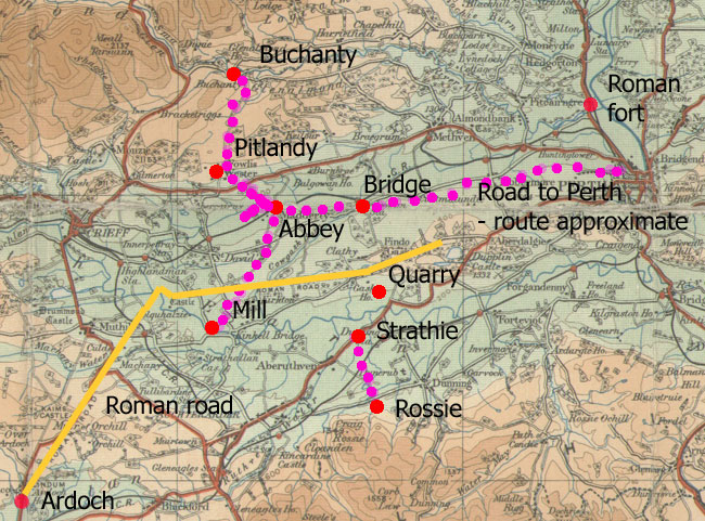 |
| This map shows only the roads
mentioned in charters as well as the Roman road.
Other roads can be presumed, particularly around
Perth which had links to Edinburgh, Dundee, Forfar
and Dunkeld. The course of the Roman road from Dupplin
to the fort on the River Tay is uncertain |
The abbey was founded in 1200 by Gilbert, Earl of Strathearn,
on an island site some 5 miles east of Crieff. There
was a pre-existing Celtic community on the island, that
was integrated with the new Augustinian house.
The abbey was given various privileges such as hunting,
fishing, timber, access to building stone, free passage
and mills and soon became well-established.
Of the roads mentioned in the charters there was one
leading north from Fowlis to Buchanty. As Fowlis was
a stronghold of the Earls there were probably routes
leading from Fowlis to other parts of the earldom.
 |
| Remains of Inchaffray
Abbey. Its remains were extensively quarried for
use in the area. |
Another
road led to Perth by a ford called Athebethy where the
monks were allowed to use a bridge provided they repaired
it (some say built it). This was over the Cowgask Burn
and the road must have followed the dry ground south
of the Pow. Beyond Athebethy the actual route is uncertain
although it must have passed close to Tibbermore and
perhaps the Old Gallows Road which existed at this time
(see Scone charters - Tibbermore).
In
the 1260's a short-lived route must have grown up between
the abbey and a quarry which they were allowed to use.
The location of the quarry was either at Findogask,
or Nethergask 2 or 3 miles to the west of this: in either
case a direct route can be assumed.
South
of the Earn a road is mentioned between Rossie and Strathie
but it is not clear what route there might have been
to the abbey from these places. However, Rossie was
very likely to have been on an east-west route between
Auchterarder and Dunning that probably skirted the lower
slopes of the hills hereabouts.
Nearer
to the abbey a bridge was built to give access to the
island, and a causeway across the marshy ground of the
Pow. It terminated at a farm called Causeyend and was
said to have still been visible in 1908 (Charters of
Inchaffray, p.299). Another earlier causeway is indicated
by a Kintocher to the west.
Other
than these there were local routes in Madderty (just
south of the abbey) itself, mentioned in the mid-1500's,
and a couple of references to north street in Perth,
and Perth bridge.
While
these are the routes mentioned specifically in the charters,
there is a map in Charters of Inchaffray depicting the
medieval landscape of Strathearn which has a couple
of puzzling points, viz. the Fowlis to Buchanty road
is not shown, and a road is shown extending south from
the abbey to a ford at south Kinkell. There is no reference
in the charters to this road although no doubt there
would have been a route to Auchterarder, which was an
early burgh, and the abbey had a mill nearby. A route
is shown between the abbey and Fowlis when the causeway
ended at Causeyhead, although it may be that he is showing
the causeway and the track that continued it to Fowlis.
Also
of interest are comments by Gilbert and Neville on routes,
easily accessed in chapter 1 of Neville which deals
with the geography of settlement in early medieval Strathearn
and which includes aspects relevant to routes. Among
these are sites suitable for human settlement, resources
that could be exploited, administrative centres for
the Earldom at places such as Dunfallin, Innerpeffray,
Crieff and Fowlis, fortified sites and mills.
There
was also of course the Roman road along the Gask ridge
that ran between Ardoch and the fort of Bertha at the
mouth of the Almond and was ideally situated for nearby
settlements.
Sources
The charters appear in the following:
• Liber
Insule Missarum, Bannatyne Club, Edinburgh 1847
• Charters Bulls and Other
Documents relating to the Abbey of Inchaffray, edited
by William A Lindsay, John Dowden and J
Maitland Thomson. Scottish History Society, Edinburgh
1908
• The
Earls of Strathearn, from the Twelfth to the Mid-Fourteenth
Century, with an Edition of their Written Acts. Cynthia
J. Neville, PhD thesis, University of Aberdeen,
1983 - see Vol.2 for charters
• People of Medieval Scotland
(POMS)
Details of charters pre-1314 can be
found on the PoMS website. Search
"sources" by reference number, e.g.
3/21/69
Amanda Beam, John Bradley,
Dauvit Broun, John Reuben Davies, Matthew Hammond, Michele
Pasin (with others), The People
of Medieval Scotland, 1093�1314 (Glasgow and London,
2012) www.poms.ac.uk.
See also:
Inchaffray Abbey, Perth & Kinross: excavation and research,
1987, Gordon Ewart, Proc Soc Antiq Scot, 126 (1996),
469-516
The Historical Geography of Strathmore and its Highland
Boundary Zone, J. Gilbert, Ph.D. thesis, Edinburgh University,
1954
A Medieval Landscape: Central Strathearn and Madderty,
John Gilbert
Madderty: A Short History of an Ancient Parish, Bessie
Maclagan, 1932
History of the Pow of Inchaffray, Norman Watson, 1997,
ISBN, 0 9528762 1 3
The
Roman Gask Project
Since we are concerned solely with the references to
roads and bridges, the Charters Bulls and Other Documents
relating to the Abbey of Inchaffray volume (Charters
of Inchaffray) will prove adequate for this purpose
although references to the other sources are provided.
Where a reference to roads appears only in another source
and not in the Charters of Inchaffray volume this is
noted below.
PERTH
Carta terre de Perthe
Charter LXX, p. 62, abstract p.203. Date c. 1245
Quitclaim by William, son of Hawock, which mentions land
in North Street, Perth.
Lib.Ins.Mis. No. 39, p. 38.
Carta Willelmi filij hauyk de terra de Perthe
Charter LXXI, Page 63, abstract p.203. Date c.1245
Another charter of William, son of Hawock, mentioning
the same land in North Street, Perth.
Lib.Ins.Mis. No.
40, p. 39.
Charter LX, page 51. Mention of bridge of Perth, date
1234
Charter CXI The Charters of Inchaffray has a note (p.
292) on the chapel of the bridge of Perth.
ROSSIE
Grant of land in the tenement of Rossie
Charter CII, Page 93, Abstract p. 216. Date c.1272, (Neville
1266)
 |
| A fairly stratight
course between Rossie and Strathy can be assumed.
The ford north of Strathy would have given access
to the abbey. |
This was a grant by Malise, son of Gilbert the late earl
of Strathearn of three acres of land in Rossie (about
2 miles west of Dunning).
The boundaries were: “from the petary of Rossy called
Pethath in Gaelic as the stream of the said petary descends
on its eastern side as far as the road which stretches
from Strathyn to Rossy, and so by that road towards the
south as far as a stone marker made by me, then to another
marker then towards the west side by white bounds, namely,
a little path to the said petary and so on the north side
to where the said stream leaves the petary.” As well
as some rights of pasture they were allowed to take 20
cart-loads of peat annually, or if they preferred, 80
horse-loads.
scilicet. a petario de Rossy qui Scocie
dicitur Pethath sicut riuulus dicti petarij discendit
versus orientalem partem vsque ad viam que se extendit
de Strathyn vsque ad Rossy et sic per illam viam versus
austrum vsque ad aseruum lapidum per me factum ibidem
et sic similiter vsque ad alium asseruum per me factum
et sic versus occidentalem partem per albam metam scilicet
paruam semitam vsque ad dictum petarium et sic versus
aquilonalem partem vsque ad exitum dicti riuuli dicti
petarij…..
Also Lib.Ins.Mis. No. 63, p. 62; Neville,
add.chrs no.12, p.189; POMS - 3/21/69
Interpretation
On page 60 of Charters, Rossie and Strathy are listed
as if a pair (De Strathyn et Rossyn) which might explain
why they were connected by a road, although this could
have occured for other reasons. The ford north of Strathy
might also have been significant.
There is no trace of the road though a direct course
would be possible given the topography. The footpath
to the petary was very likely local.
PETLANDY
Grant of land in Petlandy by Luke, son of Theobald
Charter CIII, Page 94, Abstracts p. 216. Date c.1272
 |
| Routes between the abbey, Fowlis
and Buchanty |
This was a grant of “that whole piece of land
in my land of pechlandy which lies between the land
which my father and I charitably conferred to the said
abbot and convent called fithlerflath and the great
road which goes towards buchteny (Buchanty) and so by
that road towards the north as far as the land of dunyduf
which Bricius of Ardrossan had once held of me and my
heirs at feufarm (land tenure where the owner is paid
an annual sum), with that piece of land extending from
the east to the west as far as that stream which runs
between pethlandy and pethmane, which land contains
four acres and a little more.“ The brew house for
Pitlandy and common pasture rights were also granted.
...totam illam particulam terre In terra
mea de pechlandy . quod iacet Inter terram quam pater
meus et ego dictis abbati et conuentui caritatiue contulimus
in terra que uocatur fithlerflath et viam magnam que
vadit et tendit uersus buchteny . et sic per illam viam
versus aquilonem vsque ad terram de dunyduf quam bricius
de ardrossan quondam de me et heredibus meis ad feudo
firmam tenuit . vna cum illa particula terre que se
extendit ab oriente versus occidentem vsque ad riuulum
illum qui currit Inter pethlandy et pethmane . que quidem
particule terre continue continent in se quatuor acras
terre et aliquantulum plus...
Also Lib.Ins.Mis. No. 62, p. 60 (Carta de Petlandy pro
quatuor acris); Neville add. chrs 22, page 211; POMS
- 3/470/2
Interpretation
The locations can be easily seen just north of Fowlis
Wester - Pethmane is now Pitmonie. Although the placenames
of Fithlerflath and Dunyduf are lost, the small size
of the grant indicates that they were near to Pitlandy.
The road to Buchanty must have had much the same line
of the present day road though it is not clear if it
extended to the north or south at each end. A route
from the abbey is implied by the grants, perhaps initally
by boat then by the causeway that was made "towards
our desmesne lands of Fowlis" c.1375.
-----------------------------------------------------
PETLANDY
Grant by Luke, son of Theobald, of a toft and croft
in Petlandy
Charter CV, Page 96/97, abstract p. 217. Date c.1275.
 In
this charter, Luke grants the abbey a croft and toft
in his tenement of Pitlandy “close to the door
of my house, on the north side of the great road which
goes to the church of Fowlis and by which way one goes
to Buthny (Buchanty), namely, from the ford on the north
side of my house and ascending by the said stream as
far as a great stone beside this stream and so on the
east side as far as the land of Martin, my son-in-law,
and so descending on the south side to the said great
road and by the same road to the aforesaid ford.”
This totalled a quarter of an acre in extent. He also
granted them the brew house of Pitlandy and the right
to take peat and broom. In
this charter, Luke grants the abbey a croft and toft
in his tenement of Pitlandy “close to the door
of my house, on the north side of the great road which
goes to the church of Fowlis and by which way one goes
to Buthny (Buchanty), namely, from the ford on the north
side of my house and ascending by the said stream as
far as a great stone beside this stream and so on the
east side as far as the land of Martin, my son-in-law,
and so descending on the south side to the said great
road and by the same road to the aforesaid ford.”
This totalled a quarter of an acre in extent. He also
granted them the brew house of Pitlandy and the right
to take peat and broom.
.....vnum croftum et toftum que sunt
in tenemento meo de Petlandy propinquiora lacencia ante
ostium domus mee ex parte aquiline magne vie que venit
ad ecciesiam de Fowlis per quam Itur versus Buthny videlicet
a vado ex parte aquilonari domus mee et sic ascendendo
per dictum riuulum vsque ad magnam lapidem luxta dictum
riuulum et sic versus orientalem partem vsque ad terram
Martini generis (sic) mei et sic discendendo versus
meridionalem partem vsque ad dictam magnam viam et sic
per eandem viam vsque ad predictum vadum….
Also Lib.Ins.Mis. No. 66, p. 65; Neville
- add. chrs no 23, page 215; POMS 3/470/3 .
Interpretation
See above charter.
ROAD TO PERTH BY ATHEBETHY
John Cumyn’s grant of right of way by his wood
and the bridge of the black ford
Charter CVIII, Page 99/100, abstract page 218. Date 1278
 |
| Although there was clearly a
route to Perth, its course is known only approximately. |
This grant gave the abbey “the right of free passage
with animals, carriages and other of their goods by the
public road that leads from the said monastery by the
black ford, called Athebethy in Gaelic in the wood of
Rosmadirdyne as far as the town of Perth, and strengthening
the bridge there on our land, making it firm, maintaining
it and meeting the expenses.” The abbey was allowed
to use it freely without any hinderance from the grantor,
his heirs or his servants.
…..libera potestatem transeundi cum animalibus, cariagis
et aliis bonis suis per publicam viam que ducit a dicto
monasterio per nigrum vadum qui scotice dicitur athebethy,
in nemore nostro de Rosmadirdyne usque ad villam de Perthe,
pontemque ibidem firmandi super terram nostram et firmatum
sustenandi sumptiibus dictorum abbatis et conuentus, eodem
que ponte utendi in perpetuum pro libero
Also Lib.Ins.Mis. No. 36, p. 35; POMS
- 3/167/12
Interpretation
This is usually translated as the abbey being given
the right to build a bridge but the use of firmandi
(strengthening, making firm) suggests there was an existing
bridge which provided they repaired it and met the costs
of maintenance they could use it without charge. Whatever
the case, there was a bridge at Athebethy which is likely
to have been located over the Cowgask Burn near to Ross
(probably the Rosmadirdyne of the charter). From the
wording of the charter (and there being a pre-existing
bridge) there must have been a route to Perth. There
are no indications of the road today though it could
have gone directly from the abbey to the ford, avoiding
the marshy ground near the Pow rather than up to Dubbends.
Indeed, Bessie Maclagan (Madderty: A Short History of
An Ancient Parish, 1932, page 51) says a road passed
through Redhills and Williamston at the time of Lord
Lynedoch (1748-1843) and that traces were still visible
in the 1930's. It was called the Royal Road. From the
ford onwards it would have had much the same line as
the modern road to Perth as this would keep it clear
of the marshy ground of the Pow.
ABBEY BRIDGE
Grant by Brice of Ardrossan of sixteen acres
Charter XCIX, Page 90, Abstract p. 215. Date 1271
 The
sixteen acres in question were next to the abbey’s
bridge on the east, in the field which is called Langflathe. The
sixteen acres in question were next to the abbey’s
bridge on the east, in the field which is called Langflathe.
..illas sexdecim acras terre citas juxta pontem Abbathie
ex parte orientali in campo qui vocatur langflathe….
Also Lib.Ins.Mis. No. 19, p. 21;
Neville - add.chrs 27, page 224, POMS - 3/51/2
Interpretation
This was presumably near the modern bridge.With
the Pow having been canalised, and the ground more marshy
in the middle ages, its location may not have been the
same as the modern bridge.
CAUSEWAY
Declaration by David, earl of Strathern, that a grant
of subsidy by the abbey must not be drawn into a precedent
Charter CXXXVIII, Page 131/2, Abstract p. 233. Date 1375.
 |
| From Causeyend it would be quite
easy to reach Fowlis. |
The subsidies referred to were for “the construction
of bridges and the causeway lying on the west of the said
abbey through the marsh towards our desmesne lands of
Fowlis” (trans. from abstract).
Interpretation
Charters of Inchaffray notes (p.299) that the causeway
“can still be traced by a broad line of scattered
stones, dislodged and spread by the plough; the ground
on either side being stoneless. At its north end stood
in the sixteenth century the farm of Calsayend, and
the site is still known locally as “the end of
the causeway.” It would have allowed easy access
to Fowlis.
Calsayend is shown on Stobie’s
map (1783) about 500 metres from the abbey. There
are no definite traces on the aerial images available
on the internet although interestingly enough the track
shown on Stobie running west to Kintocher can be clearly
seen. Although Kintocher means “head of the causeway”
it cannot be the same causeway as it is mentioned in
a charter dating from between 1226-34 (Charters No.58,
p.59) which is 150 years earlier than the abbey’s
causeway. It is of course tempting to assume that the
“tocher” was Roman, there being a known Roman
road and camp about 2 miles away and Fendoch 4 miles
to the north but evidence would be needed to confirm
this. It could just as well have been post-Roman and
needed to cross the very marshy land around the Pow
Water.
NETHERGASK
Earl Malise’s grant of leave to take stone from
his quarry of Nethergask
Charter XCV, p. 85. Abstract p. 212. Date 1266.
 |
| Quarry of Nethergask.
There is some uncertainty about its location. |
The charter granted the abbey leave to quarry stone
at the Earl's quarry and land of Nethergask for the
building of the church and other monastic buildings.
They also had free transit to the quarry and Nethergask,
along with free entrance and exit for their men, animals,
carts and waggons. They were also given two acres of
land next to the west side of the quarry where they
could build a house and collect and cut the stones.
Lib.Ins.Mis. No. 64, p. 63; Neville,
chrs no. 52, p. 96; POMS - 3/21/48
Interpretation
In Charters of Inchaffray (p.288) there is a note
that the local tradition was that the quarry
(NMRS record) lay a short distance south-east of the
old
church of Findogask (NMRS record). The writer, however,
thinks it more likely to have been somewhere in Trinity
Gask which was the old name for Nethergask and was two
miles or so to the west. This is an important point
for determining the route to the abbey because of the
distance between the two possible locations. In either
case we would expect a straight route to have been followed
though there are no traces today.
MADDERTY
 |
| The drain forms field boundaries
on the 25" map |
A number of late charters (1558, 1559, 1566) list lands
around Madderty with the same placenames occuring in most
and mentioning a gait, a calsey, a public road and a peat
gait. With the help of the 25" map and a plan
of part of Madderty from 1790 it is possible to identify
some of these places (see map) but not enough of them
to be certain of all the roads. Extracts from each of
the charters with notes are given below. All the "roads"
are very local.
The following three charters refer to a gait, and a
peat gait that must be the same.
Liber Insule Missarum, no.8, page 122. Dated 1558. Gait
...inter silvam vocatam Incheviott et lie gait passand
fra the Todhill to the lang medo ex occidentali viridem
hortum vulgariter the grene zaird
The wood of Incheviott was near Woodend (Charters, p.317)
but the location of the Todhill and the long meadow
are not known. There is a possibility that the garden
shown on the 1790 plan is the grene zaird of the charter.
Liber Insule Missarum, no. 14, page 124. c.1559.
Peit gait
...inter sylvam vocatam Inchecheviot and lie peit
gait passand fra ye west nuke of ye Todhill to ye lang
medo ex occidentali viridem hortum vulgariter ye grene
zaird
The wording is so similar to the charter above that
it must be the same road.
Liber Insule Missarum, no. 27, page 128. Dated 1566.
Payit gett and calsay
... fra the auld wod dyck eist to the grene yairde
and Priouris medo with the moss lyand vpone the north
syde of the Todhill to the lang medo stank fray the
payit gett eist to the Calsay
This also refers to the peat gait. The calsey is also
mentioned in the next charter.
-------------------------------------
Liber Insule Missarum, no. 10, page 122. Dated 1559.
Calsey
...lie Calsey que ducit ad silvam de Inchecheviot
The causeway is shown on the plan at Mosside and led
west towards Woodend and the wood of Incheviott. It
is clearly a different causeway from the one mentioned
in charter CXXXVIII above.
Liber Insule Missarum, no. 12, page 123. Dated 1559.
Public way
...publicum vicum quo itur ad ecclesiam de Madirtie
The location of this public way which goes to the
church of Madderty is difficult. As the places mentioned
are near the centre of Madderty it may have been the
track passing Thornhill or that marked on the plan as
going to the manse.
Top
-
|