|
Move
cursor over map
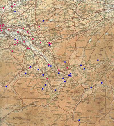
Map
based on 1/4" OS map of 1936. With thanks to Ordnance
Survey
Text
only
River
Crossings and Placenames
West
of River Clyde
River Crossings
Polmadie Burn
Identification
Over Polmadie Burn west of Rutherglen.
NS 602 630. Pont’s Renfrewshire original shows
what appears to be a crossing on this burn - it does
not appear on Blaeu.
Associated route
This is likely to have been on a route between Rutherglen
and Glasgow. It is worth noting that Polmadie was one
of the original toll points for Rutherglen which may
indicate an early route through this area.
River Calder
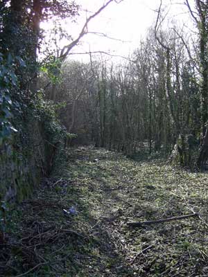
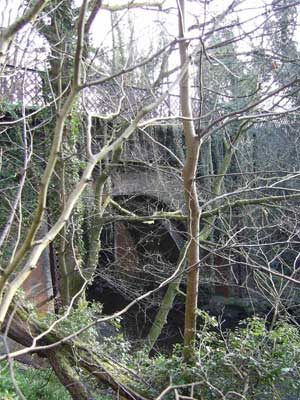
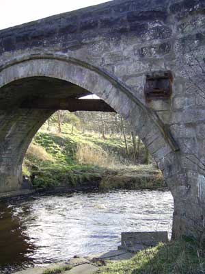
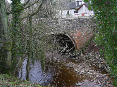
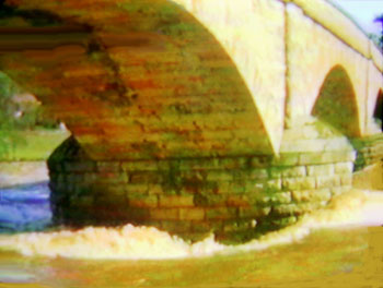
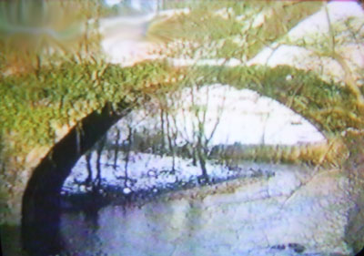
1. Blantyre - first crossing
on River Calder near Blantyre
Identification
Old Priory Bridge near main road between Hamilton and
Glasgow. NS 6782 5841.
See NMRS NS65
NE7
Associated route
Hamilton to Glasgow - this appears on Roy. Although
the bridge is not thought to be earlier than the 17th
century, Pont could be showing an earlier bridge or
a ford. There is no tradition of a bridge having being
built by the monks so the name may just refer to it
being close to Blantyre Priory, which was established
by monks from Jedburgh. As can be seen from the photes
the approach road is badly overgrown and the bridge
itself has trees growing on it. The different phases
of the bridge as mentioned in the NMRS record can be
seen by clicking on the second photograph. Other
image.
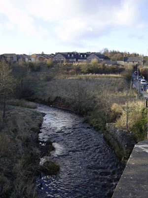
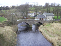
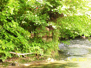
2. Kaldar - second
crossing on River Calder near Kaldar.

Identification
Given its position downstream from the confluence of
the Calder with the burn running from Nerston it is
likely to be on the minor road from Flemington through
Barnhill to Blantyre (present High Blantyre). This road
with a bridge is shown on Roy. The present day bridge
is of fairly recent date but the river (see photo) could
be forded hereabouts although there would be steep slopes
to negotiate on either side of the river. NS 677 574.
Associated route
From the route shown on Roy the most likely explanation
is that this developed as a slightly quicker route to
Glasgow by heading directly for Flemington rather than
joining the Hamilton - Glasgow route near Priory Bridge.
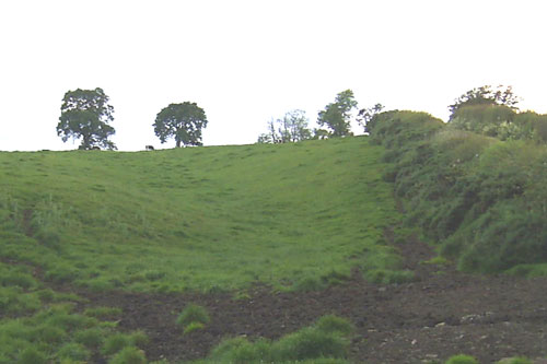
3. Calderwood Castle -
third crossing over River Calder near Calderwood Castle.
It is just above the confluence of the burn mentioned
in 2 above.

Identification
While it may have been connected with the castle (near
Craigneath Castle) it is more likely to have been at
Crossbasket where Roy shows a route. The eastern approach
to a ford would have been steep but it is more level
on the other side of the river. NS 667 565.
Associated route
In Roy’s day this was the only crossing between
the (East) Kilbride area and Blantyre with routes beyond
these places to Eaglesham and Ayrshire and to Bothwell
Bridge and the east.
Pont does show Bothwell Bridge but in the absence of
confirmatory evidence we cannot assume that any long
distance route existed in his time so it is safer to
assume the more local route.
4. Newhous - fourth crossing
over River Calder at Newhouse
Identification
Given its proximity to Torrance and being downstream
from the Rotten Burn this was probably near present
Newhousemill although his Newhous is not shown as a
mill. NS 655 534. The bridge as shown above does not
appear particularly old although it is very narrow.
The second photo shows the most likely spot for a crossing
as other locations upstream and downstream have steep
or near vertical approaches. There is no sign of approach
roads on either side of the river.
Associated route
No road is shown on Roy so it may just have allowed
nearby farms to access the (East) Kilbride area and
beyond.
River Avon
5. Hamilton - first crossing
on River Avon near Ross and Haughhead.
Identification
Old Avon Bridge - one mile sw of town centre close to
A72. On Pont’s original map this is clearly shown
as a bridge. Although it is shown as downstream from
the Barncluith Burn all the evidence points to it being
the Old Avon Bridge which was upstream from this burn.
The bridge itself (it has been extensively restored)
is said to have been built by the monks from Lesmahagow
Priory. NS 7332 5463. See NMRS NS75
SW9.
Associated route
Although we cannot say with certainty what the original
purpose of the bridge was, it is clear enough that by
Pont’s day it would have facilitated travel north
and south of the Avon, certainly to Lanark via Crossford
and to the south.
By the mid-1700’s the main route to the south passed
over the bridge.
6. Glassford - second crossing
on River Avon
 Identification Identification
Bridgeholm on A712, 2 miles east of Strathaven. NS 733
455.
Associated route
This is a puzzling crossing. Roy shows a route from
Lesmahagow to the crossing and, north of that, a road
running past Glassford Kirk which runs only for another
two or three miles to terminate at Thinacres. There
is no Strathaven - Stonehouse link nor with Hamilton
to the north - in any case there is a more direct Hamilton
- Lesmahagow link through Larkhall. It is hard to account
for the Lesmahagow link unless it goes back to the Priory
in the middle ages. The only other reasonable explanation
would be access to a mill or to Glassford Kirk.
Possible fording point over Avon
near Glassford
7. Barncluith
Burn running into River Avon near to Old Avon Bridge.
Identification
Near Barncluith, south of town centre. NS 729 547.
Associated route
It is shown on Pont’s original map as a ford, i.e.
the road line goes through the river. The 1850’s
6" OS
map (sheet XVIII - NW corner of sheet) shows a ford
here.
It is unlikely that this crossing being so near to the
Old Avon Bridge was of more than local use, perhaps
to give access to Barncluith.
River Nethan
8. On River Nethan near Clyde
at Crossford
Identification
At Nethanfoot, near Crossford. NS 824 470. NMRS NS84
NW68
Associated route
This was on the route between Hamilton and Lanark which
crossed the Clyde at Crossford. Thomas Reid (Fords,
Ferries, Floats and Bridges near Lanark, PSAS, Vol.47,
(1912-13),page 235) confirms a route here in 1650
when Cromwell’s forces were in the area, and the
route is shown on Roy circa 1750.
9. Craighead
Identification
Craighead, at Lesmahagow. This is probably the bridge
located at NS 814 404 (access just south of filling
station). There is a later bridge just to the north
of this one.
Associated route
Although on Roy’s map this is on a north-south
route and would also have given access to Lanark we
cannot say that this was the case in Pont’s day,
although likely enough.
West of River Clyde
Placenames
10. Spittal, near
River Calder west of Blantyre
Identification
Spittal. NS 673 586.
Associated route
May just refer to a hospital run by the Priory at Blantyre,
although it is on or near to a Hamilton to Rutherglen/Glasgow
route.
11. Sandford
 Identification Identification
Sandford. It is uncertain if the name refers to the
Avon or the Kype Water. The village is 2 miles south-east
of Strathaven. The photo shows the old bridge (later
than Pont) over the Avon. NS 720 430.
Associated route
This is on the Strathaven - Lesmahagow route shown by
Roy. We cannot say with certainty that this route existed
in Pont’s time although in his lists of distances
there was a route between Ayr and Lanark that must have
passed through here or nearby. At the very least the
ford would have allowed access to Strathaven for local
farms.
.
Possible holloway leading
down towards the above bridge
12. Spittel, near
Blackwood
Identification
Spittal, two miles north-west of Blackwood. NS 773 448.
It is not known if it ever catered for travellers.
Associated route
It is 200 or so metres from a road Roy shows running
from Lesmahagow to Stonehouse and about 500 metres north
of the Roman road but any link with these roads would
be tenuous without additional evidence.
13. Lochgait, near Drumclog
Identification
Lochgate, west of Drumclog. NS 6237.
Associated route
It could mean way to the loch (now drained) in which
case it would have had local use only, or the way by
the loch which is more likely as there was a route here
(more or less on the A71 line) in the middle ages.
14. Foulford
Identification
Near Auchlochan, between Lesmahagow and Coalburn. NS
8137.
Associated route
Given the absence of any roads passing through here
on Roy’s maps, this ford may just have been of
local use.
15. N & O Stockbrigges
Identification
Stockbriggs and Over Stockbriggs, 2 miles north west
of Coalburn. NS 7936.
Associated route
If referring to a bridge or causeway it was likely of
local use only. Roy shows no routes in the area.
16. Glassfurd
(see crossing above)
Identification
Glassford, near Strathaven.
Associated route
It is not clear if the name refers to a local ford near
the village or down at the Avon. As said there, any
route would probably be local.
17. Crosfurt
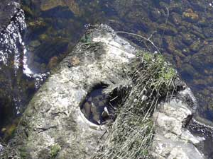 |
|
 |
| Holes in river bed
under Crossford Bridge |
Identification
Crossford on River Clyde. NS 828 465.
Associated route
 |
| Crossford Bridge
(later than Pont) when the water was high - the
"post holes" are on the right: with thanks
to Ian Jones |
This was on the Hamilton - Lanark route, see Thomas
Reid (op.cit. page 235). The bridge here dates from
1793 and prior to that time there was a ford and a ferry.
There is a mention of a Crossford in the Liber Calchou
(Book of Kelso) in the mid-1100's and that a road led
to it but this appears to have been over the DouglasWater
a few miles to the south. In 1650 it was used by Cromwellian
forces. J B Greenshields in the Annals
of Lesmahagow (page 40) has the interesting observation
that a number of holes in the river bed seem to have
been used for posts across which wattle panels would
be laid to deepen the river and so allow the use of
the ferry in times of drought. Nether
and Over Corsfurd were on the east side of the river.
18. Spittal, above
Lesmahagow
Identification
Approximate location would be at Birkwood just south
of Kirkmuirhill. NS 799 421.
Associated route
This was on or near the north- south route shown on
Roy which may have existed in Pont’s day, given
his listing of the distance between Glasgow and Douglas.
East of River Clyde
River Crossings
River Kelvin
1. Partick
Identification
Partick Old Bridge. NS 5620 6634. See NMRS NS56
NE 5
Associated route
The bridge
was on the early route between Glasgow and Dunbarton
and was completed in 1577.
2. Boigton (shown also on
Dunbarton map)
Identification
South-west of Torrance.
This is not the "Roman"
bridge as proved by the stream running from Milngavie
to the Kelvin and the position of Kessington (NS 5671).
The next stream to the east has a Fluchter nearby which
suggests this crossing was just south-west of Torrance
(NS 6173). Pont shows a Badhindrocht (drochaid, a bridge)
nearby. There is a slight possibility that the crossing
was the stepping stones shown on the 1925 1" OS
map between Cadder and Balmore but against this is the
fact that no such route is shown on Roy. There is also
the possibility that the crossing was at the present
day location which is shown on Roy.
Associated route
This is uncertain although a route north through present
day Torrance to the Campsies and one coming from Kirkintilloch
are suggestive.
3. Kirkintilloch (shown also on Dunbarton map)
Identification
On Luggie Water in town centre. NS
6574. NMRS NS67
SE9. In 1672 an earlier ruinous bridge was replaced
and is likely to be that shown on Pont.
Associated route
The crossing is shown on the road between Glasgow and
Kirkintilloch depicted on this map and there seems to
have been a route of sorts to Kilsyth..
River Clyde
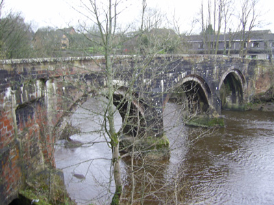
4. Glasgow
Identification
Predecessor of Stockwell Bridge in Glasgow. NS 5917
6457. NMRS NS56SE
458. There was a timber bridge here from very early
times as it was in a decayed condition about 1340. It
was replaced by a stone
bridge built by Bishop Rae in 1345 which itself
was replaced about 1855. There was a nearby ford used
in mediaeval times; however, the crossing shown by Pont
was the bridge itself.
Associated route
The Renfrew maps shows the road from Paisley crossing
this bridge but it would also have covered any other
routes such as from Rutherglen or Cathcart.
5. Clyde Bridge, Bothwell
Identification
Bothwell Bridge. NS 7107 5776. NMRS NS75
NW8. Although the present bridge is said to be 17th
century there may have been an earlier bridge here.
Indeed Blaeu shows a bridge and the Pont original has
the place name Clydesbrigh although his map is somewhat
indistinct at the actual location.
Associated route
There has to be a presumption that it served both north-south
and east-west routes.
Molendinar Burn, Glasgow
6 and 7. Glasgow, Molendinar Burn
Identification
Molendinar Burn. NS 6064, NS
6065.
He shows these two crossings aligned with the two main
streets running east from High Street, probably Drygate
and Gallowgate. This identification is supported by
a map depicting Glasgow in 1547. The crossing nearest
the Clyde is shown on the Pont original as a bridge
with a short length of road to its east, the other may
have been a fording point although this illustration
shows a bridge was built at some time.
Associated route
Routes to the east are suggested.
Tollcross
Burn
8. Stream opposite Rutherglen
Identification
Tollcross Burn. Bridge near Tollcross. NS 635 634. The
best fit would be at Tollcross or at Shettleston.
Associated route
If the crossing was at Tollcross this would have led
to Hamilton and the south; if at Shettleston it would
have led to the Monklands area.
North Calder Water
9. River opposite Flemington
Identification
 |
| Bridge
remains. With thanks to Robert Murray |
Bridge over North Calder Water near to River Clyde.
It is hard to tell both from Blaeu and the Pont original
if this was where the A74 crosses the North Calder or
nearer the Clyde at the site of the no longer existing
Old Calder Bridge. Both are shown on Roy. NS 6862. (See
report
by Robert Murray on West of Scotland Archaeology Service
site).
Associated route
If it was on the main road it would have led to Edinburgh
in Roy’s day. The alternative would have led to
Uddingston and Hamilton by Bothwell Bridge. These possibilities
are suggestive only and would need definite proof.
10. Same river, near Garturk
Identification
Over North Calder, just west of A725 Bellshill to Coatbridge
Road. NS 7262.
Associated route
This crossing is depicted as just west of the Shirrel
Burn. If it was very close to this it would fit Roy’s
crossing and road which led to the Monklands but it
may have been further west with no clear reason for
its presence except perhaps a kirk that lay on the north
side of the river although that is unlikely as it was
in a different parish. Given the east-west trend of
the river here the crossing must have been on a north-south
line
11. Shirrel
Burn, tributary of North Calder near Garturk
Identification
Crossing near to present day Shirrel Farm. NS 7461.
It is quite close to the above crossing.
Associated route
It may just have been of local use as the Shirrel is
not a particularly significant burn.
12. Same river, near Gimmerstone
Identification
North Calder, near Gartness, south-east of Airdrie and
east of A73. NS 780 644 approx..
Associated route
Roy does not show a north south route here so it is
unlikely to have been on what is now the A73 route.
It is however less than two miles to Airdrie and may
have been a convenient route for places south of the
river to reach the town.
13. Tributary of North Calder Water
at Kirkwood
Identification
 |
| Bridge over Luggie Burn. With
thanks to Robert Murray |
Over Luggie Burn at Bargeddie, 2
miles west of Coatbridge and just north of the A8. NS
706 637 approx.
Associated route
Given the north-south orientation of the Luggie Burn
this could have been on an east-west route between Glasgow
and the Monklands. It might also just have been local
as Roy’s route is a mile north of here.
South Calder Water
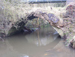
Shown as tributary of Clyde, near to Bothwell
14. At Parkhead
Identification
Over South Calder near Jerviston and north of Forgewood
- one and a half miles north of Motherwell. NS 750 587
approx.
Associated route
There is no nearby road shown on Roy’s map. The
omission of the bridge at Bothwellhaugh
(given its supposed Roman age-see photo)
suggests that this bridge was not linked with it as
the Bothwellhaugh bridge would have given easy access
to the Motherwell area from Bothwell Bridge. This leaves
just the possibility of it being local or on a route
from the Motherwell area to the north although this
is unlikely when nothing is shown on Roy.
15. At Thostoun
Identification
Over South Calder near to Cleland House. NS 785 575
approx.
Associated route
Despite its approximate location this is at least a
mile from the nearest of Roy’s roads with no particularly
obvious function, except local movement.
16. Burnhead, near Bonkle
Identification
On South Calder, just west of Bonkle. NS 830 568 approx.
Associated route
Like the crossing below there are no links with any
of Roy’s routes. It may just have been for local
use.
17. Tributary of South Calder at
Bridgend
Identification
Auchter Water at Bonkle, close to above. NS 834 566.
Associated route
The implied route would be south of the South Calder
Water which would lead to the Wishaw area and also to
the crossing above. However, on Roy’s map the road
from the east (a road leaves the Edinburgh - Glasgow
road at Kirk O’Shotts and runs to Allanton and
then Bonkle) terminates at Bonkle nor is there a road
associated with the previous crossing which indicates
any movement to the Wishaw area may just have been local.
Mouse Water
Shown as river just north of Lanark
18. On river just north of Lanark, near to confluence
with Clyde.
 |
| Mousemill Bridge - with thanks
to Ian Jones |
Identification
Mousemill Old Bridge over Mouse
Water. The first mention of a (wooden) bridge here was
in 1587. It was replaced with a stone bridge about 1649.
NS 8694 4420. See NMRS NS84
SE3 and T Reid’s study (op.cit.) for further
details as well as this old photograph
when it was still in a reasonable condition.
Associated route
This is on the early Lanark-Crossford route which would
have led to Hamilton and ultimately to Glasgow.
19. Same river, near Dyck
Identification
Cleghorn Bridge over Mouse Water, east of Cleghorn.
It had been thought to be Roman as a Roman road passes
through here although it is more likely that it crossed
at a nearby ford. Nevertheless there was a bridge here
at least in late mediaeval times (it is mentioned in
1512-13) and certainly in Pont’s day. NS 9047 4526.
See NMRS NS94
NW3 and T Reid‘s study (op.cit).
Associated route
Pont shows a mill here but it would also have led to
what was a main road in Roy’s day (partially following
the course of the Roman road) up towards Carluke. Having
said that there was a shorter route from Lanark to Carluke,
as well as one to the east via Carstairs.
East of River Clyde
Placenames
20. Strongait, near Kirkintilloch
Identification
Not identified, although Blacklands (shown south-west
of Strongait) is at NS 671 707.
Leadmanfoord, near Moffat
Water (tributary of North Calder) in east of map
Identification
Ford Bridge, 3 ½ miles east of Airdrie on A89
and 1 mile west of Caldercruix. NS 802 672. This is
confirmed by Roy who shows Leadmanford. The 1:25000
map shows Ford Bridge and Stepends Farm. In Pont’s
day it was presumably a ford.
Associated route
On Roy’s map, at Caldercruix one mile east of the
ford, he shows his road (from Airdrie) dividing with
one branch heading to Avonbridge and Linlithgow and
the other heading for Armadale and the east. This latter
road could well be the road shown on Pont’s Lothian
and Linlithgow map that runs from Edinburgh through
Bathgate to beyond Barbauchlaw (near Armadale). It may
in fact be the line of the road the monks of Newbattle
are said to have built in the early middle ages between
Newbattle Abbey (near Dalkeith) over to their lands
in the Monklands (Airdrie/Coatbridge area) - see The
Road from Newbattle Abbey to the Monklands
for more information.
Regarding the other road, there is a mention dating
from 1723 in McFarlane’s Geographical Collections
(Vol 1, p.318) of the Muir Road from Linlithgow bridge
to Glasgow which is likely to have passed over this
ford.
Given Pont’s inclusion of Linlithgow bridge and
Avonbridge as well as the road heading past Armadale
(strictly speaking, it is shown on Blaeu and not the
Pont original so may date from the mid 1600’s),
it is reasonable enough to assume these routes existed
at that time.
21. Spittel Scheen near to Mouse Water
Identification
Not identified. Perhaps near Kilncadzow NS 8848.
22. Hil, above Mouse Water in
south-east of map.
Identification
Hole, one mile east of Kilncadzow, near A721, NS 898
481.
Although noted on Blaeu and the original manuscript
map as Hil, it is shown as Hole on Roy and later maps.
The likelihood is that is from Heol, early Welsh for
a road, as it lies on the Roman road.
Associated route
The Roman road north of Castledykes heading towards
Carluke.
23. Bridgend (see 17
above)
Identification
Auchter water at Bonkle. NS 8356.
24. Hyndford
Identification
Hyndford, on River Clyde, near Lanark. NS 9141. T
Reid in his study of river crossings near Lanark
details various fords and ferries in the vicinity of
Hyndford. The use of the place name indicates the presence
of a ford before Pont’s day and probably during
it.
Associated route
The most likely use of the ford would have been to travel
between Lanark and Biggar and possibly Carnwath as well
as the upper reaches of the Clyde valley.
25. N & O Corsfurd on
River Clyde
Identification
Crossford. NS 8246. Again, Reid
(op.cit. p.235) details the crossing point here which
seems to have been an early one on the route between
Hamilton and Lanark. The bridge was built in 1793.
Associated route
Hamilton to Lanark
UPPER
CLYDESDALE
River
Crossings and Placenames
River
Crossings None depicted
Placenames
1.
Carnwath
Identification
Old ford over Carnwath Burn, just west of village. NS
975 466 Wath is an Anglo-Saxon word meaning ford and
it is thought (see for example NSA
- go to non-subscriber, browse scanned pages) that the
ford was just west of Carnwath over the Carnwath Burn.
The presence of the motte so near to this ford may indicate
it was partly sited there to control movement using
the ford.
Associated
route By Roy�s day Carnwath was on a number of main
routes leading to Edinburgh, Peebles, Biggar, Lanark
and Carluke. While not definite it would seem reasonable
to assume the ford was used in Pont�s day by the Edinburgh
road (shown on the Lothians sheet as running on the
north side of the Pentlands) and by routes going to
Carstairs and Lanark.
2.
Spittel, at bend of Clyde
near Carnwath
Identification
Spittal, one mile south of Carnwath. NS 988 450.
Associated
route Without confirming its origins it is hard to say
if this was used by travellers although it may be significant
that it was on the course of the Roman road (see RCAHMS,
Inventory of Ancient Monuments in Lanarkshire, 1978,
page 137, no. 262)
3.
Stoneypeth, near Dunsyre.
Identification
Stonypath,
1 mile west of Dunsyre. NT 0548. This also appears on
the Lothians sheet where it is placed above the road
depicted on that map which runs from Edinburgh to (presumably)
Carnwath. Roy shows the same route quite clearly but
again the present Stonypath is about one km north of
the road. The name itself is very old appearing as Staneypethe
in the Register of the Great Seal of Scotland in 1411.
Associated
route On balance it probably relates to the Edinburgh
road (even an earlier course of this) rather than a
north-south route as shown on recent maps, as this track
only appears from 1868 (see 6"map,
sheet XXI - centre left bottom of sheet) onwards.
4.
Spittel, near Biggar
Identification
Spittal,
2 miles east of Biggar near Skirling. NT 069 384.
Associated
route Again, it is hard to say if this was just
a hospital or if it served travellers as well. However,
it is very close to a route shown by Roy that led to
Edinburgh and also to the route to Pebbles through Broughton
and Drumelzier. In addition it was sited very close
to where these routes crossed the stream.
5.
Kraufurd

Identification
Crawford. NS 9520. The NSA
gives an interesting etymology as the road or passage
of blood referring perhaps to the passage of Roman roads
through Crawford although the more likely derivation
is crow ford. The ford was very probably in the very
centre of Crawford (see 6"
map - sheet XLVII NW corner of sheet) where the
Roman road from Nithsdale crossed the river to join
the road from Annandale. Associated route The
fact that the Roman road from Nithsdale crossed here
shows the antiquity of the ford and it is likely that
the motte at Crawford was placed nearby to control a
strategic route between north and south. Having said
that it is not clear what the status of the ford was
in Pont�s day, particularly as there was another ford
at Roberton just north of here.
6.
N & O Brigtoun, north of Douglas
Identification It is hard to identify these although
it is likely that they refer to a crossing of the Douglas
Water or the Poniel Burn, somewhere near Happenden,
north-east of Douglas. Forrest�s map of 1816 shows a
Bridgend on the old road that crossed Broken Cross Muir
(NS 853 352) but Roy shows nothing in this area so the
Bridgend may just refer to a bridge built on this road
well after Pont�s time (see Poniel Old Bridge, NMRS
NS83
NE49).
Associated
route Probably north-south but further evidence
would be needed to say anything more positive.
7.
Hyndford (see
above)
Identification
Hyndford, 3 miles south of Lanark on River Clyde. NS
9141.
8.
Crookbait, at top of map near
River Clyde
Looking towards Tillieford near to Crookbait
Near Crookboat.
There were several ferries on this stretch
Identification
Crookboat. NS 900 396. This was one of the ferries mentioned
by T
Reid (p.221) in his study of river crossings near
Lanark.
Associated
route It would have led between Lanark and Douglas
and other routes to the south.
9.
Neth. & Over Baithils, opposite Mouse
Water and west of Lanark.

Identification
These names must be associated with the old Clydesholme
ferry or boat which was just upstream from the present
bridge at Kirkfieldbank. T Reid (op.cit. p.223) gives
details of the ferry which was first mentioned in 1491.
Located approx. NS 8743.
Associated
route Reid notes that this was on a very old route
between the Lothians and Ayrshire, as well as Galloway.
10.
Baithouses, near Hyndford
Identification
One of the numerous ferries across the Clyde in
this area. Located on the north bank of the Clyde very
near to Charleston NS 913 417. See T Reid (op.cit. p.218/9)
Associated
route Lanark to Biggar
11.
Coulnauch, near Hyndford
Identification
This would have been another ferry in this area. It
is now called Cobblehaugh and must have been sited near
the farm. NS 9242. Cobble is an old word for boat and
the Coul in Pont's original map has the same meaning
(the Scottish National Dictionary has an entry for coul
fat meaning tub or similar vessel). See T Reid (op.cit.,p.218/9)
Associated
route Probably Pettinain to Lanark rather than Biggar
to Lanark.
12.
Tillyfurd, near Lanark
Identification
This is on the Pont original but not on Blaeu. It is
sited at NS 892 405. It was an important crossing used
to bring coal and peat from the Douglas area into Lanark.
See T Reid, (op.cit.,p.221).
Associated
route Lanark to Douglas and area.
13.
Outhclyd, near Biggar
Identification
Wolfclyde, one and a half miles south west of Biggar
on A72. NT 020 362. Reid (op.cit.,p.215) suggests this
derives from Wathclyde where wath has the meaning of
ford.
Associated
route Although Reid says that it allowed access
to Carmichael, Symington and the Douglas district this
was probably at quite a late date as no road is shown
on Roy. Nevertheless, the antiquity of the name suggests
it was used at sometime perhaps to give local access
to Biggar in the middle ages.
back
to previous
|