Teviotdale
Overview
Pont Texts
River Crossings
Placenames
Overview
All of the river crossings and several of
the placenames relate to long distance routes. Caddon
Water and Gatehoopeknow suggest a route to Peebles and
we know from other sources that Brigheuch was linked
to the Minchmoor road which ran over to Traquhair and
would have allowed Peebles and ultimately Clydesdale
to be reached from Selkirk. Caddon Water also seems
to relate to an early Selkirk Edinburgh road. Neufird
is a ford used by a later route to Moffat and Hoscott
helps to confirm that the Craik Cross Roman road was
in use as a via regia in the middle ages. Houpaslett
nearby is off the line of this road so may indicate
more local use. The early bridge at Hawick suggests
a route south towards Langholm and that at Bonjedburgh
would have allowed Jedburgh to be accessed from the
north.
In the Melrose area there was a wooden toll bridge
that probably gave access to Selkirk and Hawick from
Edinburgh and Lauder; Craikkesfoorde and Rippeth may
have been connected to the abbeys gaining access to
their holdings north of here. At Kelso there were known
to have been bridges both at Roxburgh and Kelso in the
middle ages allowing access to Berwick, Edinburgh, Jedburgh
etc.
It is not known what route "Yetholm" might
refer to though it is on a natural route between Wooler
and Kelso. Gaitshaw is probably connected with Hounam
Grange as an early charter refers to a road in the area.
The remaining placenames are suggestive of local routes
though Stunleyford is on a drove road.
A number of spittals are shown as they sometimes catered
for pilgrims and travellers. Until more is known about
the purpose of specific spittals it is best not to place
too much reliance on them as route indicators.
Texts written by or derived from Pont indicate a number
of routes existed and these are listed below.
Larger
map
| River Crossings |
|
Placenames |
|
Note: Gatehoopknow and Smailholm
and Ednam Spittels are not shown on the Teviotdale map

Map based on quarter-inch OS maps, published
1935 & 1945.
With thanks to Ordnance Survey.
Pont Texts
A number of texts written by or derived from
Pont gives distances between towns. It is very likely
that these relate to routes because the distances must
have been measured and there would be little point in
knowing the mileage unless people were travelling between
these places. In some cases he refers directly to "the
way to" or gives a list of intermediate places
as if they were on a route. He also shows river crossings
that must have been used for journeys. There is in any
case evidence from other sources that there were routes
at this time. The texts can be viewed on the NLS Pont
Website and are also in MacFarlane's Geographical
Collections.
So far as this map goes, the following entries indicate
routes through this area:
- Berwik Kelso 20 Later maps
show this running though Coldstream;
- Haick Jedburg 8 From later
maps this probably went directly over to Denholm from
Jedburgh and then directly to Hawick;
- Jedburg Selkirk 8 This would
have used the crossing near Bonjedburgh - see immediately
below;
- Jedburg Kelso 7 Later maps
suggest the route went by a still existing track over
to Crailing and then followed the line of the present
day road through Eckford to Kelso;
- Selkirk Edinburgh 22 m (see
NLS)
The early route seems to have used the bridge at Caddon
Foot and then went up by Clovenfords
- Annand Toun and Hermitage Castle
in Liddisdail 24 m This would have run up the Liddel
valley where there was an early route
- Annand and Haik in Teviot dail 28 m;
Annand and Jedburg 36 It is unclear if the Hawick
route went through Langholm or up Liddesdale past Hermitage.
The distance given between Hawick and Jedburgh is 8 miles
(28 + 8 = 36 miles) which suggests the Annan to Jedburgh
route went through Hawick although a more direct Jedburgh
route by Note O'The Gate was available at this time.
River Crossings
Near Cadanly,
just above River Tweed
Identification
Near Caddonfoot on Caddon Water just north of River
Tweed, NT 449 352
Associated route
The Military
Survey shows two roads running from Selkirk here.
One keeps to the east of the Caddon Water and runs towards
Dalkeith, the other runs to Innerleithen and Peebles.
The record of cannon being transported from Peebles
to Selkirk via Darnick (near Melrose) rather than the
Minchmoor suggests a route existed through Innerleithen
along or near the Tweed (The
Roads that led to Edinburgh etc, Harry R G Inglis, PSAS,
Vol. 50, (1915-16), p. 43). It is not clear if at
the time of Pont a route to Peebles followed the Tweed
as the present day road does or went up to Clovenfords
as shown on the Military Survey map.
At Galasheels,
on river south of Gala Water
Identification
Crossing stream in Galashiels, NT 490 360
Associated route
The orientation of this stream favours a route on
a NW-SE line but it is difficult to say what any through
route might have been, perhaps Selkirk to Dalkeith if
the Tweed was crossed at Boldside as suggested by the
Military
Survey map. The town of Galashiels did not exist
at the time.
At Haick on
Slittrick Water
Identification
 There
was a known mediaeval
bridge in Hawick over the Slitrig, said to have
been built in the time of Alexander II. NT 502 144 There
was a known mediaeval
bridge in Hawick over the Slitrig, said to have
been built in the time of Alexander II. NT 502 144
Associated route
Given that it was in a town it may have been primarily
for local convenience though it would also be useful
for those travelling longer distances. MacFarlane (Geographical
Collections, Vol.2) has a distance of 28 miles between
Hawick and Annan suggesting a route which presumably
went by Langholm. There were also links to Jedburgh
and Selkirk.
At Bonjedburgh
Identification
Bridge over Teviot at present day Bridgend, 1 mile
SE of Ancrum, NT 639 237
Associated route
MacFarlane (Geographical Collections, Vol.2) shows
distances between Jedburgh and Selkirk and Jedburgh
and Kelso which imply routes existed in 1646 when this
list of distances was made up. Melrose is not mentioned.
MacKenzie in Lilliesleaf and Its Old Roads (Transactions
of the Hawick Archaelogical Society, 1947) gives an
interesting account of the two mediaeval Selkirk to
Jedburgh routes, both of which would have used this
crossing. The bridge is mentioned in 1547.
Placenames
Bridgend,
Kelso
Identification
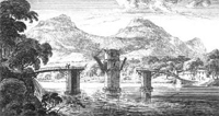
At south end of present day bridge over the Tweed.
NT 727 337. No bridge is shown on the map but this may
be because the bridge was broken down by the local people
as a defensive measure during Hertford’s campaign of
1547. The bridge was of stone and erected in 1330. (Image
of ferry in the 1680's from Slezer's Theatrum Scotiae
- NLS site)
Associated route
Although the bridge would have facilitated movement
between Roxburgh and Kelso, its function was probably
more related to a route to Edinburgh by Smailholm and
Legerwood (The
Roads that led to Edinburgh etc, Harry R G Inglis, PSAS,
Vol. 50, (1915-16), p. 40) and would also have given
access to Coldstream, Berwick, Jeburgh and Hawick.
Briggend,
near Melrose
Identification
 Bridgend,
2 miles west of Melrose, NT 520 354. Although not shown
here, there was a known bridge
(NMRS record) at this location at the time. Inglis (op.cit.,
p.43 )suggests it may have been destroyed in 1544 at
the same time as Melrose Abbey. Bridgend,
2 miles west of Melrose, NT 520 354. Although not shown
here, there was a known bridge
(NMRS record) at this location at the time. Inglis (op.cit.,
p.43 )suggests it may have been destroyed in 1544 at
the same time as Melrose Abbey.
Associated route
Traditionally it is thought to have been associated
with the Girthgate that ran up to Soutra but Inglis
thinks it would have been used between Lauder and Selkirk,
Hawick and Jedburgh.
Brigheuch
Identification
Near Bridgelands, 1˝ miles NNE of Selkirk, NT 481
304. Kelso Abbey had land on both sides of the River
Ettrick, with pasture rights on part of Minchmoor, granted
them by Alexander II. A condition of the grant was that
they maintain the bridge existing at the Ettrick.
Associated route
There is undoubtedly a connection with the Minchmoor
route both because of the pasture rights and the references
to Minchmoor in Kelso charters relating to Lesmahagow.
That said, it is not completely clear where the route
was. Inglis (Ancient
Border Highways: The Minchmoor (Catrail) Road, the Wheel
Causeway, the Annandale Forest Road, the Well Path,
and the Enterkin, Harry R G Inglis, PSAS, Vol. 58 (1923-24),
pps 203-23) gives an interesting account of the
Minchmoor, noting that there was an original path from
the river crossing which later became turnpiked on its
western stretch between Troquhair and Brown Knowe, where
it ran south to the Yarrow valley. This suggests that
the original Minchmoor road ran from the bridge over
Lingley Hill and Peat Law to the Three Brethren, Broomy
Law and Brown Knowe and then took up the line of the
Minchmoor turnpike to Troquhair. It is not clear, however,
given the absence of the bridge in Pont’s day what the
later status of this route was.
Craikkesfoorde
Identification
Craigsford, on riverside just west of Earlston.
NT 570 382
Associated route
Stobie’s map
(1770) suggests this was used to access Earlston both
from Melrose and St Boswells. It would also have served
local needs.
Eckfurd
Identification
Eckford, 5 miles SSW of Kelso on road to Jedburgh.
NT 703 265. The old
6” map (sheet XV) shows an “Eck Ford” over the Teviot.
J S M Macdonald in the Placenames of Roxburghshire derives
it from the personal name Ecca which places it well
into Anglian times.
Associated route
The Military
Survey shows the Hawick-Kelso road crossing the
Kale rather than the Teviot at the “Eck Ford” which
suggest a local use at least in later times.
Gatehouse
Cott, near Roull
Identification
Gatehousecote, 1 mile NE Bonchester Bridge, NT 599
132. J S M Macdonald (Placenames of Roxburghshire, Hawick
Archaeological Society, 1991) gives this as “the cottage
beside the goat shed”.
Associated route
Early maps do not offer any particular support for
a road near this place though as the area was well populated
in mediaeval times with a settlement at Town O’Rule,
one miles to the west and a grange at Abbotsrule, one
mile to the east, there may have been a local track
at that time.
Gaitshawtour
and Gaitshaw
Identification
Gateshaw, near Hownam Grange. NT 779 225
Associated route
J S M Macdonald (op.cit.) interprets Gaitshaw as
Goat’s Wood but a doubt must remain as the Military
Survey shows a road running south from Morebattle to
Hownam and beyond. Given the possibility that the Military
Survey was not completed in this area, Stobie’s map
gives a much better indication of the road network.
His map shows that Morebattle would give access to Eckford,
Yetholm and Kelso to the north and a road into England
in the south.
In any case Hownam was a grange of Melrose Abbey and
records of the late 1100’s refer to a road across the
lands of Grubeshude (see Stobie for Gribbet, NT 780
236) where the monks could take their wagons to and
from Howden where Gateshaw was located (Scottish Monastic
Landscapes, Derek Hall, Tempus 2006, p.155).
Hosccott
Identification
Hoscote in Roberton parish, NT 3911. Macdonald (op.cit)
suggests the name could indicate a lodging house for
travellers although she notes that other interpretations
are possible.
Associated route
Hoscote lies on the route taken by the road shown
on the Military
Survey along the Borthwick Water which itself is
probably the Roxburgh - Annandale road mentioned in
early charters and is also on the presumed continuation
of the Craik Cross Roman road.
Houppaslett
Identification
Either Howpasley at NT 346 076 or Old Howpasley
at NT 349 067 just south of Craik. Macdonald (op.cit)
gives the meaning as “the valley with the sunken path”.
Associated route
It may relate to a route shown on Ainslie running
from Craik to Falnash and Teviothead, 8 miles SW of
Hawick but this is not certain.
Maisondieu
Identification
Maisondieu, 1˝ miles SSE of Kelso, about 400 metres
north of farmhouse. NT 714 327. NMRS record.
Associated route
It cannot be said with certainty if its function
included catering for travellers. In any case it is
so near Roxburgh to which roads ran that it would not
offer much additional evidence in support of these.
Noufird
Identification
Howford at Ettrickbridge End, NT 391 243
Associated Route
The Military
Survey (c.1750) has a route from Moffat to Selkirk
pass over the Ettrick Water at this point. A bridge
(NMRS record) was built here in 1628 but was ruinous
by 1715.
Rippeth
Identification
Redpath, 2˝ miles SSE of Earlston, NT 585 385
Associated route
Given the presumed age of this place name it is
tempting to think that a road would have ran north through
here from Dryburgh Abbey but there does not seem to
be any record of such a road. Another possibility is
that it was on a road between Melrose and Earlston but
early maps do not support this.
Rutherford
Identification
Rutherford Mill, 3 miles E of Maxton, on River Tweed,
NT 662 312. The 1863 6”
OS map (sheet IX) shows a ford at Rutherford Mill
although there was a ferry one mile to the west at NT
650 319. Macdonald (op.cit) suggests the name means
“cattle ford” from the Old English hryther and ford.
Associated route
The Military
Survey and Stobie
show a road running past Rutherford Mill on the south
side of the river and on the north side, one about Ľ
mile from the ferry but more than a mile from the ford;
this suggests that there was no through route. The name
itself is more suggestive of a local route.
Spittelbank,
near Eckford
Identification
Although not appearing on later maps the location
would have been on the north side of the Kale Water
near Eckford, NT 71 27 approx.
Associated route
This location would place it on the Jedburgh to
Kelso route but there is no supporting evidence for
a spittal here or that it would have catered for travellers.
Spittell
Identification
Spittal near to Ancrum, NT 647 247
Associated route
Although little is known about this spittal (NMRS
62SW6), it does lie very near to Dere Street which
may indicate use by travellers.
Spittell, east
of Denhoome
Identification
Spittal-on-Rule near Denholm, NT 589 199
Associated route
This is listed as a leper hospital with a foundation
date of 1425/26 (Scottish Monastic Landscapes, Derek
Hall, Tempus 2006) so would not have catered for travellers.
It was however sited very near the Hawick - Jedburgh
road which would have facilitated the collecting of
alms.
Stunleyfoord,
near Leithope Forest
Identification
The best fit is a ford shown on the old 6”
map (sheet XXXV) over the Long Burn in Leithope
Forest, 9 miles SE of Jedburgh. NT 739 009.
Associated route
A track is shown on the 1st edition 1”
map (and present day maps) running from Byrness in Northumberland
(on A68, 5 miles south of Carter Bar) through the ford
and over to Edgerton (NT 70 11). On the 6" map
it is marked as a drove road. The Thieves Knowe that
it passes north of the ford suggests it was used by
raiders before droving became established after the
Union of the Crowns in the early 1600's.
Wadeshill
and Wadespinnle, Southdean
Identification
On Jed Water at NT 650 100 approx.
Associated route
These are included because the wade element may
indicate a ford. Wadeshill does not appear on any other
early map and no roads are shown in the area. If the
name does refer to a ford, it would probably have been
of local use only.
Yettum and K
of Yettum
Identification
Yetholm/Kirk Yetholm. NT 82 28.
Associated route
Although the name appears in the 1100’s (J S M Macdonald,
op.cit) it is not clear what road the “yett” refers
to. It could be a very old name given the Anglian settlement
in the area. The Military
Survey and Stobie
show roads running up the Beaumont towards Wooler, south
along the Beaumont and across the Cheviots, towards
Kelso and, on the Military Survey, one along the course
of the present day Pennine Way.
Top
|
