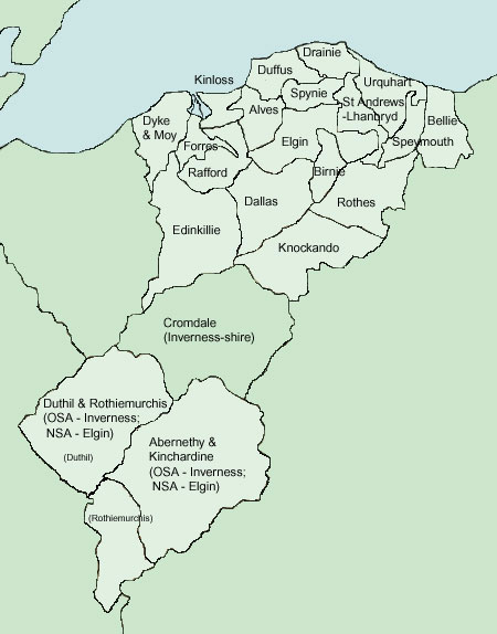
The
text below is mostly summaries with some extracts from
the original text. The links are to Google Books, usually
to the first item of interest rather than the first
page of a parish. The NSA for Elginshire is volume 13.
Some notes from MacFarlane's Geographical Collections
(Volume I) have been added - these are useful as they
date from the 1720's. See here
for further information and links.
Additional
information about parishes can be found on the Vision
of Britain site and on Scotland's
Places.
The maps are based on the OS Tourist Map of Lower Strathspey
1921 and quarter-inch OS map The Eastern Highlands,
1923. With thanks to Ordnance Survey. The overview map
is from Black
& Hall's map of Scotland, 1854, courtesy of
David
Rumsey Historical Map Collection. Their images are
copyright Cartography Associates but have been made
available under a Creative
Commons license for non-commercial use.
There
are several references to the presence of the Romans
in the area. Later work has confirmed a couple of the
sites such as a camp at Bellie and disproved others
though there is still a degree of uncertainty about
one or two sites. There is no doubt that the Romans
did campaign in the area though they may not have remained
long enough to develop a road system. Antiquarian writers
had proposed two roads: the one crossing Aberdenshire
and Banffshire as far as the camp at Bellie; and one
running from Braemar to Forres. The existence of these
roads has not been confirmed by present day research.
Although
there were roads in mediaeval times (mentioned in charters)
and no doubt prior to that given that Moray was an important
Pictish centre,
the only ones mentioned
are a causeway at Spynie revealed when the loch was
drained and one in the same parish that formed a boundary
between certain lands. There
was also a very old road in Duffus that ran for three
miles between Roseisle and Burghead which some thought
Roman and others that it had been made by Cromwell's
soldiers. Although not mentioned in the Elgin accounts
there is reference to a very old bridge at the Boat
of Bridge in Boharm parish (bordering with Rothes parish)
that some had thought Roman and was at least mediaeval
in date.
As
always, bridges were important in the early days and
there are frequent mentions of these or the lack of
them. A number were destroyed or damaged in the floods
of 1829. There were ferries but they could be dangerous
- one at Forres became overloaded on a market day and
capsized with the loss of eleven lives.
It is interesting to see that timber
was floated down the rivers.
Depending
on the parish, coal or peat was used as fuel, the coal
being landed at the various ports on the coast, which
also allowed easy export of the produce of the country.
There were numerous fairs and markets that were so much
a feature of everyday life at the time, and there are
references in passing to the trade in cattle. The OSA
for Forres says that the merchants in the town used
to travel through the northern counties and Orkney but
that this trade had declined ever since these places
established their own shops.
At
the time of the OSA some parishes had good statute labour
roads; others poor. The Dallas account indicates that
without the interest of the gentry the statute labour
might not be properly applied. There is the usual contrast
with the time of the NSA when turnpikes and Parliamentary
roads had been made and traffic had increased with regular
stage coaches and carriers.
Military
roads are mentioned and some of these are shown on the
map. Also mentioned are some early attempts at road-making
- one or two of the landowners were prominent in this
at a time when there was no general interest in roads
and a reluctance on the part of other landowners to
fund them. The reference to the Raider's Road in Rothiemurchis
may sound romantic but it was anything but. The victims
of these raids would lose a very valuable commodity,
and the perpetrators if caught received summary justice.
The Lairig Ghru pass through the Cairngorms is mentioned.
It was used by drovers and others to reach Deeside and
a path was kept clear by the removal of boulders that
had fallen in winter. The pass is over 2700 feet high.
Other
sources Roads
in 1859
This links to the 1859 Report of the Commissioners for
Inquiring into Matters relating to Public Roads in Scotland
and gives an overview of roads in Elgin at that time. A
Survey of the Province of Moray, J.Grant & W.Leslie,
1798 Contains much useful information on various topics,
including roads. The
history of the Province of Moray,by Lachlan Shaw.
Enlarged and brought down to the present time by JFS
Gordon, 1882 (3 volumes). This is a reprint of Shaw's
book first published in 1775 and brought up to date
by Gordon. The text of the above Survey of the Province
of Moray by Grant and Leslie has been incorporated in
the 1882 edition - see Editorial Preface for details
and a criticism of an 1827 edition of Shaw's work.
RCAHMS Canmore
search for "roads" in Elginshire - 76
records; also search for "track"
- 10 records. An
Account of the Great Floods of August 1829, in the
Province of Moray etc., Sir Thomas Dick Lauder.
The
Military Roads in Scotland, William Taylor, House of
Lochar, 1996.
Highland Bridges, Gillian Nelson, West Port Books, 2006.
Alves OSA
Vol.11, page 508
Page 511 Minerals, Fuel, Inns, Etc. — Coal
is used as the mosses are nearly exhausted. There is an
inn on the county road from Elgin to Forres that runs
through Alves.
As
Taylor & Skinner and the Military Survey show,
the old road between Elgin and Forres ran south
of the turnpike - the sections in red are shown
on the 6"map (Elgin
VII & XI) as military road. This is probably
an instance of the common practice of the military
working with the civilian authorities to repair
an existing road. This old road would be the one
referred to in MacFarlane.
NSA
Page 101
Page 105 Antiquities. — "The old military
road can still be traced about a quarter of a mile south
of the present turnpike." Stones from a nearby
cairn were used in building the turnpike.
Parochial Economy. — Page
110. Grain shipped at Burghead or Findhorn for London. Market-towns, Etc.—"The nearest market-towns
are Elgin on the east, and Forres on the west. The turnpike,
lying in the most centrical parts of the parish, renders
the communication with the towns very convenient. Besides
the mail to Inverness, there are two stage-coaches."
MacFarlane
Alves, Elginshire
Page 236 King’s highway runs through parish between
Elgin and Forres.
Bellie OSA
Vol.14, page 263
The name may come from Beul-aith, the mouth of the ford,
as there was a fine ford here near the church until it
was destroyed in the floods of 1768. The Duke of Cumberland
passed here in 1746 just before the battle of Culloden.
Page 265 Mention of the Boat of Bog.
Page 271 Curiosity and Antiquity.— On the
east bank of the Spey there are remains of an encampment
thought by many to have been Danish. From its square figure
it is more likely to have been Roman though it is difficult
to say when the Romans were here "unless Agricola
might land a detachment in his traverses on the coasts
of Scotland."
Bridge
over the Spey.—A bridge over the Spey at Fochabers
is very necessary as this is a busy thoroughfare that
is used for driving cattle, bringing lime from Banff into
Murray, and the movement of troops. Delays are common,
including to the mail. Many have subscribed to a bridge
but public aid will be necessary.
NSA
Page 115
Some suggest that the name comes from Beul-aith, meaning
mouth of the ford.
Page 118 Antiquities. —
"To
the north of Gordon Castle, are the remains of a
military station, which early tradition assigned
to the Danes, but which in later times has long
been known by the appellation of the " Roman
camp." Those who ascribe it to the Danes suppose
it to have been connected with a battle which they
fought with the Scots in the neighbourhood of Cullen;
but, as the Roman Eagles were once certainly displayed
upon the banks of the ancient Tuessis or Spey, it
is generally supposed that this encampment was formed
by a detachment of Agricola's troops, when he traversed
the coasts of our island, and may have been intended
to cover the ford of the river, which at that period
probably ran along the base of the bank where the
station is placed. Its quadrangular form, with its
rampart and ports, seem also to indicate, with some
degree of certainty, that it belonged to the conquerors
of the world."
Note: This was a Roman marching camp - see NMRS
record.
Page 122 Parochial Economy. Markets, Etc.—Six
markets for cattle and horses held at Fochabers, the
main village.
1842
MacFarlane
Bellie, Banffshire
Page 241 “Through this town passes the Kings High
Court way on the end of the town W.ward runs the river
Spey, where there are fine passage boats.”
Birnie OSA
Vol 9, page 155
The post goes to and from Elgin three times a week.
Page 162 Peat brought from 4 miles away. Mention of road
from Birnie to Rothes.
NSA
Page 82
Page 86 Some say there are remains of a Roman castra
at Foth (see NMRS
record).
Page 89 Parochial Economy. Means of Communication.—He
makes an interesting analogy between the health of an
animal and the condition of its blood vessels and the
state of a district and its roads (cf. our use of this
analogy in the term arterial roads).
The
statute labour has been converted but only yields L.14
so that the roads are very bad and new ones impossible.
However, it is hoped that the improvements made by Colonel
Grant of Grant will extend to the making and repair
of roads. He has in fact ordered a survey for a road
that will run north and south through the parish.
Miscellaneous
Observations. - He refers to the improvements made
in spite of the "wretched state of the roads."
Dallas OSA
Vol. 4, page 105
Page 107 Many supplement their living by carrying peats
to Elgin and Forres.
Page 110 "There is great occasion for a bridge over
the impetuous river Lossie. In particular, over that river,
where a public road from Forres and the low country crosses,
leading to the parishes of Knockando, Aberlour, Inveraven,
&c. The roads are in bad repair. The statute-labour
is but irregularly called for, and ill executed, as there
are no gentlemen of property residing in the parish. Turnpikes
would be altogether inefficient in Dallas."
NSA
Page 195
Page 199 Parochial Economy.Market-Towns.—The
nearest market towns are Forres and Elgin, 9 and 12
miles distant respectively.
Means of Communication.— With no post-office,
letters are taken either eastwards to Elgin, or westwards
to Forres. There are good county roads to both these
places, but many other roads are in poor condition.
A new road, called "the Knockando road" has
been made between Forres and the Spey and will be of
great benefit to those in the hillier parts of the parish.
The only bridge here was over the Lossie, but it was
carried away by the floods
of 1829 . If the river is high it prevents many
from attending church, however, a new bridge is soon
to be built, near the church.
Inns.—Three
in the village, and one in Kelles.
Fuel.—With ample moss, coal is hardly used.
Miscellaneous Observations. — The roads
to Forres, Elgin, and Knockando are greatly improved.
1842.
Drainie OSA
Vol.4, page 77
Page 78 Some details of imports and exports from Lossiemouth.
Page 83 Peat has to be brought from 10 miles away. Coal
is expensive because of a tax.
Page 86 Four public houses.
Page 87 The only bridge here is a small one at the outlet
of the Loch of Spynie. One is needed over the Lossie below
Elgin. The roads are statute labour and have improved
though much remains to be done. On the Highland road to
Edinburgh there are no tolls or turnpikes until Perth.
NSA
Page 145
Page 146 Mention of Canal bridge and Kay's bridge.
Page 153 Some people suggest that the fortress at Kinedder
had been a Roman outpost from Burghead (Ptoroton).
Mention of the "Warlike Hills", artificial
mounds about 20' high that are thought to have been
used for signalling in time of invasion. (Note. Samuel
Lewis in the entry for Drainie in his Topographical
Dictionary of Scotland places these on the Causea
hills - these are near Covesea, 4 miles west of Lossiemouth).
Page 156 Details of the extensive trade through Lossiemouth.
Steam vessels from London and Leith call in.
Page 157 Parochial Economy.— "Elgin,
to which there is an excellent toll-road, was, till
the introduction of steam-boats, almost the only mart
for the little traffic of this parish. There is a daily
post. The runner and postmaster are paid by Government."
1842
Duffus OSA
Vol. 8, page 384
Page 390 Details of trade through Burghead.
Page 393 As peat is exhausted, coal (from Northumberland)
has to be used although it is far too expensive because
of the "odious and impolitic tax on this commodity."
Roads. — There are no turnpikes and the statute
labour has not been commuted. Road making here is rudimentary.
It seems odd that all over Europe so much attention should
have been paid to water transport and not to roads. However,
it is very likely that as more and more roads are made,
their obvious benefits will act as an incentive to providing
them.
In a footnote he remarks on the scarcity of labour and
high wages and suggests that the military could be employed
in road-making and other public works.
NSA
Page 33
Page 36 Antiquities. - He refers to very faint
traces in the western end of the parish of what some
say was a Roman camp with a paved road leading to it
(note: it may be that he is referring to a made road
about 3 miles in length that ran between the old town
of Roseisle and Burghead. Some thought it Roman, although
one person attributed it to Cromwell's soldiers - no
trace of the road remains - see NMRS
record NJ16NW 15).
He also refers to:
"the
remains of fortifications at Burghead, by some maintained
to be Roman, and by others accounted Danish, but
very probably occupied by both nations. General
Roy, in his learned and elaborate work upon the
Roman Antiquities of Britain, makes Burghead the
most northerly regular station of that illustrious
people, the " Ptoroton" of Richard of
Cirencester, and the "Alata Castra" of
Ptolemy of Alexandria; and supports his statements
by correct references to its distance respectively
from Jussis (Spey river,) and Barris (Forres;) and
by several plausible arguments, he places Ptoroton
at the end of the ninth, and commencement of the
tenth iter of Richard; and mentions it as the chief
town of the Vacomagi, and enjoying the privileges
and immunities of Roman citizenship. A deep well,
built with a regularity and elegance seemingly beyond
the attainment of a rude people like the Danes,
has been recently discovered, and adds another argument
to these in favour of General Roy's position, which
one is ready enough to admit, upon even slenderer
grounds; because one would wish to believe that
the spot he daily treads had been familiar to the
footsteps of that imperial race, and would gladly
confer upon a place presenting few natural attractions
the charm of a reflected classical fame."
(See
NMRS records for the fort
and the well.
See also Agricola
in the Highlands? David J Breeze, Proc Soc Antiq
Scot, 120 (1990), 55-60 for an interesting account of
Agricola's campaigns in the region.
Regarding its identification with Ptolemy's Ptoreton,
the Survey of the Province of Moray, page
53 says that in the mid 1700's Burghead was called
Torytown or Terytown which is very similar to Ptoreton.
Additional weight can be given to this by noting that
the slogan/war cry associated with Hawick: teribus,
ye teri odin has been interpreted as "a phonetic
rendering of the Gaelic tir a buaidh's, tir a dion
which translated means land of victory, and land
of defence" - A Dictionary of Lowlands Scotch,
Charles MacKay, page
232. Land of defence would be a fitting name
for the earthworks at Burghead which were much more
substantial in the mid-1700's).
The NSA then discusses the possibility that Burghead
had been occupied and fortified by the Danes in their
invasion of c.1008.
Page
40 Parochial Economy. Means
of Communication.—"This parish is distant
about three miles (at its south border) from Elgin,
the market, post, and county town, with which it enjoys
easy communication by means of a turnpike road at its
west, and a good commutation road at its east end. A
light curricle conveys the mails to the villages of
Duffus, Hopeman, and Burghead, at each of which there
are branch post-offices."
Villages.—Regarding Burghead he says that
"regular communication with London, Leith, &c.
by traders and steam ships, a daily post and carriers
to and from Elgin, comfortable lodging houses, and pleasant
sea walks, add to its advantages as a watering-place."
Page 42 Inns, Etc.—There are a large number
of these.
Fuel.— Mostly coal.
Page 43 Miscellaneous Observations. - Twenty
five years ago the roads were near impassable in winter
but are now much improved. However, the commutation
funds are insufficient for making and repairing the
roads.
Places
of interest mentioned in the account. Some of the
military roads shown here were constructed in association
with the civilian authorities or partly funded by
the military - see William Taylor, The Military
Roads in Scotland for details.
NSA
Page 123
Page 124 The great highland road between Perth and Inverness
runs through the pass of Slocmuic.
Page 134 Parochial Economy. Market-Towns.—The
nearest are Inverness, Nairn and Forres, all about 26
miles away. There are feeing markets in Grantown, 8 miles
away, as well as cattle-markets from where the beasts
are taken south.
Means of Communication. Fifteen miles of the great
Highland road between Perth and Aberdeen runs through.
A post-office was set up at Carr Bridge in 1836. From
there there is a road to Grantown, on which there is a
mail-gig each day; and another road from the south of
the parish. There is a bridge over the Dulnan at Sluggan
built by the military after 1745 but almost impassable
after the floods in 1829. There is also a good bridge
over the Dulnan at Carr Bridge that was built in 1791.
Fairs.—The fairs formerly held in the kirkyard
have been partly discontinued and partly transferred to
Grantown.
Inns.—Inns on the main road at Aviemore and
Carr Bridge.
Fuel.—Peat.
1838
Dyke
and Moy OSA
Vol. 20, page 192 Villages, Inns, and Still.—"There are
villages at Broom of Moy, Kintesak, and Dyke; at which
last there is an inn, near the post road, and another
inn at the Ferry Boat, on the east side of the river."
Page 210 Roads, and Statute Labour. — "The
roads being naturally good, there are no turnpikes, nor
any need or wish for them. The statute labour is exacted,
which keeps the roads in tolerable repair. Commutation
was attempted, but it raised discontent, and was dropped."
Bridges.
— "Three stout wooden bridges, floored acrosss,
railed, and painted, have been built, at Moy, Dalvey,
and Barley-mill, near the fords of the Beg-Bourne, at
the cost of L.114, 7s. Sterling, out of five and a half
years of the stipends accruing at the last vacancy.
They
admit no carriages, nor even the post cart; but the horse
and mail can pass. Three small stone bridges were also
built on the public road, out of the same fund, for L.30,
4s."
Page
219 There is one ferryman with two boats on the Findhorn.
Page 220 Peat-carts - 291; coaches - 1; chaisses - 1;
saddle and carriage horses - 13.
Page 223 Peat is very scarce and expensive though wood
is available, The removal of the coal tax will be a great
benefit.
Page 226 In 1780 a strolling packman was murdered.
Page 227 Miscellaneous Observations. — "A
stone bridge over the Findern, and another over the Big-bourne,
on the post-road, would be of great advantage to this
parish, for an open communication to all the villages
and towns west of the river, with Forres and Elgin. For
want of this, the daily posts are often long detained,
lives are frequently endangered, and sometimes lost. In
1781, 11 were lost by the oversetting of the ferry-boat
on the day of a Forres market. On such occasions, there
is no preventing the people from overloading the boat."
NSA
Page 215
Page 226 Parochial Economy. — The nearest
market town is Forres, four miles away.
Means
of Communication.— "The nearest post-office
is that of Forres. The great post-road, from Aberdeen
to Inverness, on which the mail and two stage-coaches
run daily, traverses the parish from east to west, and
county roads intersect it in all directions. A great
number of bridges span the burns which flow through
the parish, and an elegant suspension-bridge connects
it with Forres."
Inns.
— Seven ale-houses.
Fuel. — Generally turf and wood allthough
coals are landed opposite Findhorn harbour if the weather
permits. The nearest port is Nairn.
1842.
Page
554 Over the Findhorn, a dangerous river, there is one
bridge on the Aviemore to Inverness military road and
another on the military road from Granton to Fort-George,
at Dulsie. There is no bridge where it meets the great
post-road to Nairn and Inverness etc. and thus the mail
is often delayed and many lives lost. In a footnote he
says that near to Relugas, the river runs between two
rocks, only seven feet apart, which are bridged by a plank.
In flood, the river can rise more than 30 feet in this
narrow space (Rannich/Rannulf's Leap - see 25" map
Elgin
XV.15. Gillian Nelson, Highland Bridges, page 53 says
there was a wooden bridge there which was always being
washed away, and constantly being replaced. The river
actually rose 50 feet in the great flood of 1829).
Daltulich
Bridge
In
another footnote he refers to a Miss Brodie of Lethen
who had a bridge built downstream from Coulmony, near
to Relugas. It was an arch of 72 feet but within a month
it collapsed. (The present Daltulich Bridge replaced
it - see Gillian Nelson, Highland Bridges, page 53,
also photos on Braemory
site).
Roads
and Bridges. —The Forres to Granton road, crosses
the Divie by a stone bridge and the Dorback over two
stone bridges. In 1783, another bridge was built over
the Divie, near the confluence with the Findhorn.
A new road is being made by Sir James Grant on the east
side of Knock Hill through the valley of Pluscardine
which will be three miles shorter to Grantown.
The
gentlemen of the parish see that the statute labour
is performed properly but being a large parish and the
roads difficult to make, the system does not allow much
progress to be made.
Page
562 Peat is taken 10 or 12 miles to Forres to be sold.
Forres is the market town.
Rannulf's
Leap. A wooden bridge was used to span this gap
and was constantly being washed away.
Page
565 He mentions the Bridge of Rannich (at Rannulf's
Leap) said to be very old and that may have been named
after Randolph, Earl of Moray in the time of Robert
the Bruce.
NSA Page 178
Page 185 Possibility that the Doune Hill of Relugas
was "one link of a chain of signal stations used
for the purpose of communicating by fires up the twin
glens of the Findhorn and Divie. The Romans also seem
to have occupied it at one time, for Sir Thomas Dick
Lauder, by digging, found some fragments of Roman pottery
on the summit of it, which are still in his possession.
They were supposed to have had a line of posts from
Forres to Brae Mar, and thence to Perth, and this was
unquestionably one of them...." (Note: The possibility
that the Romans used it as a signal station does not
seem to have been confirmed by later research - see
for example Canmore
record)
A nice video of the Findhorn in spate
near Rannulf's Leap (I think) taken by Bobjwaller. In
the 1829 flood, the viewing point would be under water!
Page 188 Breed of Live-Stock.—Black cattle
are bought in autumn then sold the next summer to cattle
dealers for the south. Sheep also are sold.
Page 191 Parochial Economy. Markets, Means of Communication,
Etc. - There are markets at Forres, Nairn and Grantown.
Forres is the nearest post-office although a mail gig
runs from Forres to Grantown and on to Aviemore to the
Highland road, and passes along the road that runs through
this parish on the east side of the Findhorn. There
are also weekly carriers on this road. This turnpike
road is 11 miles long and much of it was made about
10 years ago. The old route from Forres to Grantown
is three miles longer.
A parish road leads off this, near to the church, and
crosses the Findhorn by the bridge of Daltulich then
passes through the forest of Darnaway to the Inverness
to Aberdeen toll-road. There are also about 15 or 20
miles of road made by two of the proprietors. There
are three toll-bars but those travelling the whole length
of the turnpike pay only at two.
Bridges.—The
floods of 1829 swept away two bridges over the Divie
and the Dorbach, just above their confluence. These
were replaced c.1831.
Page 194 Inns.—Two small inns convenient
for travellers. Toll-keepers can sell whisky in their
houses.
Fuel.—Peat
is easily obtained and coal from England is brought
in at Findhorn.
1842.
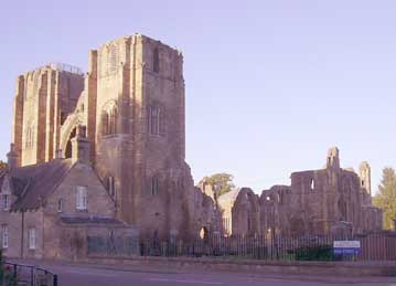
Elgin
Cathedral
at Elgin
OSA
Vol. 5, page 1
Page 9 Much grain is exported from Findhorn, Lossiemouth,
and Germach, to London, Leith, and the canal at Carron.
Page
19 Coals were first landed at Lossiemouth in 1754. At
the time there was no demand for them; nowadays 20 ships
come with English coals and 6 with Scottish. There is
an unjust tax on these coals.
A bridge over the Spey is much needed.
Mention of the boat of Bog, near the Spey.
NSA
Page 1
Page 17 Parochial Economy.
Town.— Details of the fairs and markets held
in the town.
About 5 years ago a gas company was formed and the streets
are now lit by gas. The streets have been causewayed
and have paved footpaths but are not kept clean in a
proper manner.
Means of Communication.—These are very good.
There is a post-office and three turnpike roads - the
great north road, a road to Rothes and Speyside, and
one to Lossiemouth. There are good commutation roads
to Pluscarden, Mosstowie, and Blackhills. There are
three stone, and one iron bridge over the Lossie within
the town.
The mail-coach (on the Aberdeen - Inverness road) and
mail gigs to Lossiemouth and Burghead run each day,
and there are daily stage-coaches to Inverness and Banff
where a coach from Aberdeen is met. The Defiance coach
from Edinburgh to Inverness also passes through each
day.
There are carriers to Aberdeen, Banff and Inverness
and nearby villages. Although sea-carriage is used it
is inconvenient and expensive as it stands at present.
He says that an improved and deeper harbour at Lossiemouth
would allow steam-vessels to dock and allow easy communication
with the south and London.
Page 26 Fairs.—Ten fairs for cattle, horses
etc and two hiring fairs.
Inns, Alehouses, Etc.—Over 60 in the town
and suburbs and one outside the town.
Fuel.—In the town coal is used. It comes
from Sunderland and is landed at Lossimouth and carted
the five miles to the town. In the countryside peats
and turf are still used but the effort of obtaining
them is making coal more popular there.
Miscellaneous Observations. — Since the
last account the roads are much improved though there
is still much to be done. The town now has turnpike
roads, stage-coaches, street lighting and side-pavements.
Forres
Forres
OSA
Vol. 17, page 447
Page 449 Trade.—There are 60 merchants and
shopkeepers in Forres. In the past they did much of their
business by travelling round the villages to the west
and north, particularly in Sutherland, Caithness, Ross,
and Orkney. Most of this trade has stopped as these places
have their own shops at much the same prices.
Page 453 He makes a case for a canal to be made from the
mouth of the Findhorn to the town, a distance of three
miles.
Page 455 Mention of road from Forres to Yverttown.
NSA
Page 159
Page 164 Streets of Forres are paved, and lit by gas.
Page 171 Cattle.—Many of the farmers buy
cattle from the north and sell them on to drovers from
the south after the winter. Farms close to the town
do a good trade in dairy produce.
Page
173 Parochial Economy. Town - He gives details
of the numerous markets and fairs held in the town.
Means of Communication.—The Aberdeen to
Inverness turnpike passes through the town - the mail
coach and two others run on it daily. There is also
a turnpike to Findhorn, where steam-boats from Leith
and London call in. The numerous district roads are
all in excellent order.
There are four stone bridges, and an elegant chain bridge
over the Findhorn built in 1831 to replace the former
stone bridge destroyed in the flood of 1829. It cost
L.7000, subscribed by the town and local land-owners.
There is a pontage levied for crossing.
Inns, Etc.—There are a great number of these.
Fuel.—Mostly coal from Newcastle which is
landed at Findhorn and carted to the town. Some peat
and turf is also brought in from the country but are
not much used, and are as expensive as coal.
Page 178 Miscellaneous Observations. - "During
the last thirty years the streets of the town have been
newly paved, lighted with gas, and embellished by the
erection of a number of handsome buiIdings. In 1793,
there was only one small bridge in the parish, and the
passage across the Findhorn was made in a ferry boat,
which often proved dangerous. There are now four excellent
stone-bridges on the burn, and an elegant chain-bridge
across the river. In 1806, no public conveyances passed
through the parish; now a mail-coach and two stagecoaches
pass daily."
Kinloss
There
was an important mediaeval monastery in Kinloss.
In its charters there is a mention of a road from
Forres to Elgin
OSA
Vol.1, page 462
Fish, sold in the country and in Forres. Harbour at Findhorn
with considerable trade. No particular mention of roads.
NSA
Page 202
Page 210 Parochial Economy.
Market-Town.—Forres, easily reached by a turnpike
road to Findhorn. There is a branch at the bridge of
Kinloss to Burghead and Elgin. A daily post runs the
5 miles between Forres and Findhorn.
Page 213 Fairs.— Three fairs are held annually
at Findhorn, one in October, one in March, and one in
July, on the second Wednesday (old style) of each month,
chiefly for sheep, cattle, and horses.
Inns.—
13.
Knockando OSA
Vol.4, page 302
Page 304 Miscellaneous Observations. - Peat is
used.
In the past the roads were good but have been neglected
recently. Commutation may be a more effective system.
People here "have no idea of turnpikes, or their
advantages."
NSA
Page 60
Page 60 Mention of the bridge of Craig Elachie.
Page 63 Timber floated down the Spey. In a footnote
about the floods of 1829 he says that a new road had
been made at that time and all the burns bridged but
all of these bridges except one were carried away.
Page 64 Mention of Boatman's Haugh.
View
Larger Map Telford's
bridge at Craig Elachie. Use mouse to navigate through
image.
Page 71 He describes the elegant metal bridge of Craig
Elachie, built in 1814 by the Parliamentary Commisioners
and private subscriptions. It has a span of 150 feet,
and withstood the floods of 1829. The cast iron was delivered
to Speymouth. He says that on approach "the
Craigellachie
Bridge
The
approach road
traveller
appears on crossing to be approaching a large cavern,
but feels surprised to find himself on a turnpike road,
cut for a considerable extent along a huge rock covered
with firs of a large size, and bounded by a secure parapet
wall overhanging the Spey. The height of Craig Elachie
rock, at the highest point cut down for the roadway, is
70 feet." (For details and photos see Wikipedia
article)
"There is another rock of the same name in Rothiemurchis,
and the two define the district of Strathspey. In the
past signals by fire were used to warn of an enemy approaching
- hence the Grants motto, Stand fast, Craig Elachie."
Page
76 Parochial Economy.
Market-Towns, Etc.—The nearest are Charlestown
of Aberlour, 5 miles away, Rothes 10, Dufftown 15, Forres
16, Grantown 16, Elgin, Keith, and Fochabers, 20. There
is a shorter road of 13 miles to Elgin by the Mannoch
Hill, but it is not in good repair and often impassable
in winter. Most of the grain from the parish is shipped
at Garmouth, the rest at Lossiemouth and Findhorn.
Means
of Communication, Etc.—The nearest post office
is at Craig Elachie which has a foot-runner twice a week.
There are weekly carriers from Aberden to Archieston and
to Elgin. A short length of the turnpike from Elgin to
Dufftown, Grantown etc passes through at Craig Elachie.
Until recently the parish roads have been very bad but
a new road is now nearly completed through the centre
of the parish. Bye roads are very bad and some farm houses
inaccessible at times.
There is a ferry-boat at Wester Elchies on the way to
Charlestown of Aberlour etc, and one upriver at Black's
Boat in Inveraven parish, on the road to Glenlivat, Tomintoul
etc. At both, it is 1d for foot-passengers and 4d for
a horse.
There are several bridges of wood and stone beside the
one at Craigellachie, and one is planned for the burn
of Aldarder. The Craigellachie bridge has been of great
utility to this and nearby parishes; as would apply if
a bridge was to be erected over the Spey at Torndow, Kirkdals
or some other place in the upper part of the parish particularly
if the proposed road from Perth to Elgin and Forres is
ever built.
Page 81 Many sturdy beggars, and tinkers, especially in
the summer.
Inns,
Etc.—Three in the village of Archiestown, and
one at the boat of Wester Elchies.
Fuel.—Mostly
peat and turf and some wood. It is too far to the coast
to bring in coal.
1835
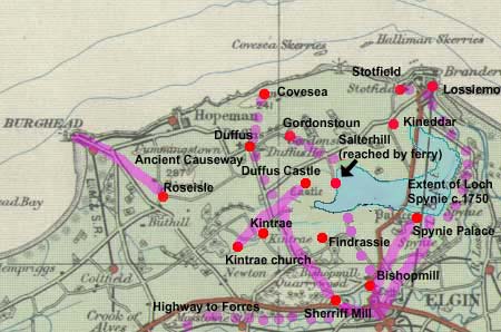
New
Spinie
Places
mentioned in charters below. The course of the roads
is approximate. Loch Spynie is shown c.1750 from
the Military Survey. Blaeu shows it was once closer
to Kintrae. The dotted lines are those roads referred
to in Young's Parish of Spynie - see notes below.
OSA
Vol. 10, page 623
Page 624 In discussing the Palace of Spynie (residence
of the Bishops of Moray) and the former extent of Loch
Spynie he notes:
"But
although it is evident, that, at a period comparatively
not remote, the sea flowed into the space which
the lake now occupies, and covered, besides, a large
extent of land at each end of it; yet it is also
obvious, that, at a still more recent period, the
bounds of this lake were more limited than at present.
For, a few years ago, when the canal, which had
long been neglected, was cleaned out and enlarged,
a causeway was discovered, stretching from this
parish quite across the lake, in which there were
several passages for the water, each about 3 feet
wide, and covered by a thick flag-stone; and, upon
its appearance, a tradition was recollected, that
this causeway was called the Bishop's Steps, and
had been formed by his influence, for the accommodation
of the ministers of St. Andrew's, who officiated
also in the church of Ogueston, (since united to
Drainy,) both having been mensal churches before
the establishment of Presbytery. Bishop Falconer
told the author this; and that the Bishop's priest,
who officiated, had prayers in the forenoon in the
one, and in the afternoon in the other, and thereafter
his dinner in the Castle every Sunday. This causeway
was soon converted, by Mr Brander of Pitgaveny,
into a substantial road, by which a more direct
communication was opened between Elgin and the shore." Note:
See Plan
of The Loch of Spynie and Adjacent Grounds, Moray
(1783) on Scotland's Places website. This shows
that work by the "Messrs. Branders" had
started on a road close to Lochside and Gilston
with a note saying "Said to be Steping stones".
West of this and just south-east of Unthank a road
is shown as "old road by the Long Steps from
Causie (Covesea) to Elgin with the "Long Steps"
just on the parish boundary. The map also shows
"steping stones said to be in this direction"
running NNE from Scarfbanks NJ236 664.
On
page 626 he says:
"The
boundaries of estates were early attended to. There
was a distinct march, dividing Spynie and Findrassie
from Kintrae and Quarrywood, by agreement, in 1226,
between Hugh de Moravia, and his brother the bishop,
and establishing the road to Sherriffmiln, Auchter-Spynie,
and Elgin, the march of property, declaring the
muirs to the east neutral ground."
Note: The wording here is different
from that covering what is presumably the same charter
mentioned in the Survey
of the Province of Moray (1882 edition, v.2,
p.112). There it talks of the highway that comes
from the castle of Duffus to Levenford (the Register
of Moray indicates this might be le neu ford -
charter 120, p. 132). It is difficult to identify
the course of the road nowadays though in general
terms it must have run from Elgin through Sherriff
Mill about one mile west of Elgin then by the line
of the minor road to the Duffus road which runs
between Finrassie and Kintrae, and then tending
over towards Duffus castle.
The Survey of the Province of Moray (v.2, p.117)
mentions another road leading from Duffus Castle
to the old church of Kintrae (Reg.
Mor. 211, p.273) and two roads from Spynie Palace
into Elgin (v.2, p.125) in a charter dating from
1566 (Reg.Mor.324,
p.395).
Robert
Young in his Parish
of Spynie (1871) mentions these roads with additional
comments that on the road leading from Elgin to
Duffus castle Loch Spynie was crossed on steps (possibly
the same as the Bishop's Steps) with carts and horses
skirting the loch, and that one of the roads leading
north from Bishopmill accessed a ferry on the loch
that went to Salterhill, and another road (perhaps
the easternmost road to Spynie Palace mentioned
above) that passed the east end of the loch to access
Lossiemouth, Kineddar and Stotfield.
See
Plan
of The Loch of Spynie and Adjacent Grounds, Moray
(1783) on Scotland's Places website for additional
information on these.
He also mentions the Elgin to Forres
highway that is shown on Taylor and Skinner and
the Military Survey - see Alves
above.
Young also gives details of the bridge at Elgin
(1630) and later roads.
Page 629 Mention of post road between Elgin and Forres
and of the intended bridge over the Spey at Fochabers.
Page 637 Advantages. - Lossiemouth, Findhorn and
Elgin are within easy reach. There is a bridge into Elgin
on the post road to Forres.
NSA
Page 95
Page 99 Parochial Economy. Village.—Bishopmill, very close to Elgin
which is the market-town.
The harbours of Lossiemouth and Burghead, and the market-town
of Elgin are easily reached. There is a cast iron bridge
into Elgin at Bishopmill where the Lossie is crossed
by the post-road to Lossiemouth. Originally of stone
it was swept away in the floods of 1829 and replaced
by one of iron. There are two stone bridges over the
Lossie on the post-roads to Forres and Duffus.
Alehouses.—"Four alehouses, two of
which are toll-houses."
Fuel.—Although peat, turf and wood are used,
the main fuel is coal, landed at Burghead and Lossiemouth.
1835.
MacFarlane
Description Parish of Spynie, Morayshire 1723
Page 230 Details of the ferries on the River Spey, viz.
boats of Budge, Fiddigh, Skirdustan or Aberlour, Delnapot,
Cromdell.
Page 231 King’s highway leading from Spey to Elgin.
Rafford OSA
Vol.16, page 338
Although peat etc is readily available, those living in
the vicinity of Burgie have to travel to the mosses of
Altyre to obtain them, at the expense of time and effort.
No particular mention of roads.
NSA
Page 238
Page 241 In speaking about how dangerous the Findhorn
and the burns of Alltyre and Rafford could be in spate,
he says that the last of these carried bridges away
during a flood in 1838.
Page 253 Parochial Economy.
Market-Town.—"There
is no market town in the parish. The nearest is Forres,
distant from the church about two and a half miles.
The parish contains no village of any size. Forres is
also the nearest post-town."
Means
of Communication.— There are three and a half
miles of turnpike road. A mail-coach and two stage-coaches
run daily on the Elgin to Forres road. The road to Craigmiln
in Dollas now continues through Dollas and Knockando
as part of a planned direct road to Perth. If completed
it will shorten the distance to Perth by 40 miles and
if not will still allow easy access to the lower parts
of the Spey.
"The
bridges on the Rafford burn were all swept away by the
flood formerly referred to, and have not been rebuilt;
those on the Altyre burn are in a state of good repair,
and highly ornamental to the scenery, especially the
one at Craigroy, than which, a more picturesque object
is scarcely to be met with."
Page
255 Fairs.—Two fairs for the sale of cattle.
Inns.—One.
Fuel.— Peat is becoming scarce as mosses
are being improved; wood is easily available; coal can
be had from the port of Findhorn.
NSA
Page 136
Page 137 "Along the margin of Loch Gamhuinn, runs
Rathad-na-meirlich (thieves' road) the common pass of
the Lochaber reivers in their excursions to Morayland."
Short video of Lairig Ghru pass on YouTube (by Benoftheforest)
The
pass of Lairig Ghru. Photo adapted from image by
user Ericoides on Wikimedia, with thanks. See original
image and details of the pass here.
See also Heritage
Paths site
for route description and more details.
Page
138 "To the east of Glen-Ennich, and about the
centre of the parish, there is a bold pass through the
mountains, named in the language of the country, Larich-ruadh,
or red pass. Through this narrow gulley, a foot-path
has been formed with much trouble by the removal of
immense blocks of granite, which have fallen from the
adjoining precipices on either side of the pass, with
the view of communicating with the southern markets
by a shorter route than the great Highland road presents.
The task of bringing cattle through this pass is one
of difficulty and danger; but a pedestrian, fond of
the grand in nature, will have his toils amply repaid,
while he wends his way along the base of the lofty Ben-Mac-dui.
The shoulder of this mountain forms in this direction
the boundary of the parish."
Page 141 Causeway to the castle at Loch-an-Eilean.
The
pass was used as a route between Strathspey and
Deeside. There is now a road past Loch Morlich to
Glen Mor and the Ski Centre where a funicular railway
climbs part of the way to the summit of Cairn Gorm.
Page
143 Parochial Economy. Market Towns.—The
nearest is Inverness, 33 miles away. Cattle are sold
at Grantown, Kingussie and Castletown of Braemar.
Means
of Communication.—A county road runs on the
south side of the Spey from Craigellachie Bridge to
the Bridge of Spey, near Kingussie. From there a ferry-boat
and several private boats allow the nearby Highland
road to be reached. There is a sub post-office at Lynwilg,
two miles away, that receives letters from Perth, Inverness,
Carr Bridge and Kingussie.
Fuel,
Etc.—Peat and wood, both easily available.
No fairs. One public-house at the boat-house of Inverdruie.
1842.
St
Andrews Lhanbryd OSA
Vol.9, page 172
Mention of the highway from Elgin to Spey.
Page 173 In describing the draining of the loch of Spynie
he notes that when this was done: "many acres were
regained, where the course of ridges, the formation of
artificial roads, and every token of ancient and unknown
cultivation, most evidently and unexpectedly appeared."
Page 174 Substantial timber bridge at the church of St
Andrews.
Page 181 Need for a bridge over the Spey at the ferry
of Fochabers. Many cattle have to cross into Banffshire
where there are many markets and the pasturage is good
and much lime is brought from that county, all at great
inconvenience without a bridge.
Notification to the custom house at Inverness has to be
made before a cargo can be landed at the posts of Findhorn,
Lossie and Spey which causes a delay of three days and
much expense.
A canal from Lossiemouth to within a mile of Elgin could
easily be made, and would need no locks.
There would be advantages in setting up a corn-market
here similar to that of Haddington.
Speymouth OSA
Vol.14, page 374
Page 378 There are 8 ferrymen, 6 shop-keepers, 5 inn and
ale-house keepers and one or two carriers in the parish.
Page 381 Although lime is easily available in Banffshire,
the expense of ferrying it over the Spey stops it being
used more widely. A bridge would remove this difficulty.
Page 393 Timber from the forests in Strathspey and Badenoch
is floated down the Spey to Garmouth, at the mouth of
the Spey, from where it is exported.
Page 396 Details of trade carried on through Speymouth.
Page 396 A Bridge on Spey at the Boat of Bog.—He
makes a lengthy argument on the importance such a bridge
would have not just for the immediate district but the
whole north-east of Scotland. He refers to the road being
used by judges to and from the circuit at Inverness, by
the military to the various forts, and generally by all
travellers. It is also the post-road and a great line
of communication from the south to the various counties
in the north.
The Spey itself is seldom fordable and the boat of Bog,
while good, is inconvenient to use and when the river
is in spate even more so, and possibly dangerous. It is
in fact surprising that nothing has been done to carry
forward such an important public undertaking.
That the project would be feasible is shown by the survey
of a Mr Stevens, an architect, who found the site suitable
for a bridge of about 100 yards in length. The estimated
cost however was 14,030 L which would only be possible
with government aid. As said it would be in the interest
of the government to expedite justice and the movement
of troops, as well as convenience the public.
He says in a footnote that the government would get a
sense of the strong desire in the district for a bridge
by noting that last year over 3000L was subscribed but
was discontinued when war broke out, as had also happened
at the time of the American war. If direct subsidy was
not forthcoming, he suggests a small temporary tax on
the northern counties.
The proposal for a bridge at Boat of Brig, 5 or 6 miles
upriver, while it might be cheaper and would be convenient
for that district, could never serve the same purpose
as one at Boat of Bog. The road to Boat of Brig from the
south and east is often impassable and could never serve
as the post-road or main line of communication even if
a road could be made between the two places, which from
the terrain seems impossible whereas the coastal route
through here is always open.
A bridge over the Findhorn would also be very useful but
if one was built over the Spey, that at Findhorn would
follow in due course, and would result in the road from
Queensferry to the Ferry of Dornoch in Sutherland being
free of all ferries and so of great benefit to the country.
Page
403 Miscellanous Observations. - Mossy turf is
used as fuel; those in Garmouth and near the coast use
coal imported from Sunderland.
The post road to Elgin enters the parish at the Boat of
Bog. The fare over the Spey here is for a single person
1d.; for a man and horse 2d.; for a chaise and pair 2s.
6d.; for a horse and cart 2d., etc. If the river is flooded,
the fare is higher. There is also a ferry at the mouth
of the Spey. Two roads lead from Garmouth, at the mouth
of the Spey to Rothes and the Highlands, and to Elgin.
These roads are in good condition as the soil is light
and the climate dry. Turnpikes are not needed and would
not be wanted as they would be too expensive for many.
It would be better to convert the statute labour into
money at the rate of 1s.6d per year.
NSA
Page 51
Page 53 The bridge of Spey was destroyed in the 1829
floods.
Page 55 Details of trade in black cattle and of trade
(coal, grain, timber etc) through the harbour at Garmouth
(much damaged in the floods of 1829).
Page 58 Parochial Economy.
"The great post road enters this parish at the
bridge of Spey, and passes through the middle of it
to Elgin. The bridge was finished in autumn 1804, and
fell in part during the flood of August 1829. A handsome
and substantial wooden arch was thrown over the fallen
part, and the bridge re-opened on the 5th December 1832.
The mail passes daily, and there is a daily runner to
Garmouth."
1835
Urquhart OSA
Vol.15, page 93
Page 94 Grain from the parish is exported at Speymouth
and Lossiemouth, and coal brought in at these places.
Page 103 Proposed Bridge.—He refers to the
excitement at the prospect that a bridge over the Spey
might be built, noting that subscriptions had begun and
hoping that government aid would be forthcoming. The ferry
is very inconvenient, sometimes dangerous, and very expensive;
and a hinderance to the march of the King's troops.
NSA
Page 44
Page 49 Parochial Economy.
Market-Town.—The nearest is Elgin, five miles
away.
Means of Communication.— Just over two miles
of turnpike. County roads have been made as required
and are in fair condition.
1835


 "the
remains of fortifications at Burghead, by some maintained
to be Roman, and by others accounted Danish, but
very probably occupied by both nations. General
Roy, in his learned and elaborate work upon the
Roman Antiquities of Britain, makes Burghead the
most northerly regular station of that illustrious
people, the " Ptoroton" of Richard of
Cirencester, and the "Alata Castra" of
Ptolemy of Alexandria; and supports his statements
by correct references to its distance respectively
from Jussis (Spey river,) and Barris (Forres;) and
by several plausible arguments, he places Ptoroton
at the end of the ninth, and commencement of the
tenth iter of Richard; and mentions it as the chief
town of the Vacomagi, and enjoying the privileges
and immunities of Roman citizenship. A deep well,
built with a regularity and elegance seemingly beyond
the attainment of a rude people like the Danes,
has been recently discovered, and adds another argument
to these in favour of General Roy's position, which
one is ready enough to admit, upon even slenderer
grounds; because one would wish to believe that
the spot he daily treads had been familiar to the
footsteps of that imperial race, and would gladly
confer upon a place presenting few natural attractions
the charm of a reflected classical fame."
"the
remains of fortifications at Burghead, by some maintained
to be Roman, and by others accounted Danish, but
very probably occupied by both nations. General
Roy, in his learned and elaborate work upon the
Roman Antiquities of Britain, makes Burghead the
most northerly regular station of that illustrious
people, the " Ptoroton" of Richard of
Cirencester, and the "Alata Castra" of
Ptolemy of Alexandria; and supports his statements
by correct references to its distance respectively
from Jussis (Spey river,) and Barris (Forres;) and
by several plausible arguments, he places Ptoroton
at the end of the ninth, and commencement of the
tenth iter of Richard; and mentions it as the chief
town of the Vacomagi, and enjoying the privileges
and immunities of Roman citizenship. A deep well,
built with a regularity and elegance seemingly beyond
the attainment of a rude people like the Danes,
has been recently discovered, and adds another argument
to these in favour of General Roy's position, which
one is ready enough to admit, upon even slenderer
grounds; because one would wish to believe that
the spot he daily treads had been familiar to the
footsteps of that imperial race, and would gladly
confer upon a place presenting few natural attractions
the charm of a reflected classical fame."


 Page
554 Over the Findhorn, a dangerous river, there is one
bridge on the Aviemore to Inverness military road and
another on the military road from Granton to Fort-George,
at Dulsie. There is no bridge where it meets the great
post-road to Nairn and Inverness etc. and thus the mail
is often delayed and many lives lost. In a footnote he
says that near to Relugas, the river runs between two
rocks, only seven feet apart, which are bridged by a plank.
In flood, the river can rise more than 30 feet in this
narrow space (Rannich/Rannulf's Leap - see 25" map
Page
554 Over the Findhorn, a dangerous river, there is one
bridge on the Aviemore to Inverness military road and
another on the military road from Granton to Fort-George,
at Dulsie. There is no bridge where it meets the great
post-road to Nairn and Inverness etc. and thus the mail
is often delayed and many lives lost. In a footnote he
says that near to Relugas, the river runs between two
rocks, only seven feet apart, which are bridged by a plank.
In flood, the river can rise more than 30 feet in this
narrow space (Rannich/Rannulf's Leap - see 25" map


 "The
boundaries of estates were early attended to. There
was a distinct march, dividing Spynie and Findrassie
from Kintrae and Quarrywood, by agreement, in 1226,
between Hugh de Moravia, and his brother the bishop,
and establishing the road to Sherriffmiln, Auchter-Spynie,
and Elgin, the march of property, declaring the
muirs to the east neutral ground."
"The
boundaries of estates were early attended to. There
was a distinct march, dividing Spynie and Findrassie
from Kintrae and Quarrywood, by agreement, in 1226,
between Hugh de Moravia, and his brother the bishop,
and establishing the road to Sherriffmiln, Auchter-Spynie,
and Elgin, the march of property, declaring the
muirs to the east neutral ground."
