|
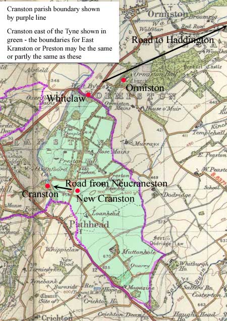
Cranston
This charter dates from the late 1200's and relates
to the grant of the lands of East Kranston or Preston
to Kelso abbey. It refers to "the road which leads
to Haddington" and to "the road that comes
from Neucraneston".
Although it contains many placenames,
many of these have been lost and this makes it very
difficult to identify the boundaries detailed in the
charter. Even if we assume the boundaries are those
of the eastern part of Cranston parish, it is still
difficult to relate the charter to these.
In view of this we will limit
ourselves to the parts of the charter that contain the
references to see if an approximate idea can be obtained
of where the roads ran.
Road to Haddington
 The
first reference is "...and by the boundary between
Preston and Ormeston, beginning at a valley to the south,
ascending upwards by a syke as far as an ancient bank,
which is the ancient boundary towards the foot of Whitelaw,
and so ascending by the said bank directly up to the
cross which is situated on the boundary between Preston
and Ormeston, and on the road which leads towards
Haddington, then from the cross towards the south-east
as far as Peth-hevid, and so descending to the stream
which is called Wreke, then ascending the same river
until it comes to the syke which leads to New Craneston..." The
first reference is "...and by the boundary between
Preston and Ormeston, beginning at a valley to the south,
ascending upwards by a syke as far as an ancient bank,
which is the ancient boundary towards the foot of Whitelaw,
and so ascending by the said bank directly up to the
cross which is situated on the boundary between Preston
and Ormeston, and on the road which leads towards
Haddington, then from the cross towards the south-east
as far as Peth-hevid, and so descending to the stream
which is called Wreke, then ascending the same river
until it comes to the syke which leads to New Craneston..."
"et per divisas inter Preston et
Ormeston, incipiendo ad unam vallem versus austrum,
ascendo sursum per syketum usque ad antiquam balcam,
quae est antiqua marchia ad pedem del Whitelaw; et sic
ascendo per dictam balcam directe usque ad crucem quae
stat in marchia inter Preston et Ormeston, in via
quae tendit versus Hadington, et a cruce versus austrum
orientis usque ad Peth-hevid; et sic descendo in rivulum
qui vocatur Wreke; et ascendendo per dictum rivulum
quosque veniat ad sycum qui venit de New Craneston"
Interpretation
This occurs after a
reference to the Water of Tyne so the presumption must
be that it was just east of the river on the boundary
of Ormiston. This is confirmed by Forrest's
map of Haddingtonshire (SW sheet) which shows Whitelaw
Hill at NT 402 672. The old church and presumed
settlement of Ormiston (the present day village dates
from 1735) were just north of the Cranston parish boundary
at NT 411 676.
One possibility is that it was
a road between Cranston (sited at NT 394 651) or Pathhead
to Haddington but against this is the fact that the
charter does not say the boundary followed the road
to Pathhead and also that the direction given is south-east
rather than south or south-west. Another possibility
is that it could have been a route between Dalkeith
or Newbattle to Haddington although the alignment with
Haddington is not as good as the other possibility.
In view of this there has to be
some doubt about the course of the road south of the
cross, however, it is clear enough in view of the mention
of Whitelaw that from this point the road would have
taken a reasonably direct line past Wester and Easter
Pencaitland to Haddington, some 8 or 9 miles away.
Road from Neucraneston
The second highway is referred to in the following:
"and by the west side of the petary as far as Oxinfalde,
from there by the cultivated land called Crossflat,
separately by the outer limits of Preston, as far as
the road which comes from Neucraneston, and by that
road separately by the foot of the slope as far as the
old course of the Tyne, until it come by that old course
to the water of Tyne, opposite the mill of wester Cranestun
below Hogam."
"et per costam petariae in occidentem
usque le Oxinfalde; et deinde per culturam quae vocatur
Crossflat seorsum per extremitates terrae de Preston,
usque in viam quae venit de Neucraneston; et
per illam viam seorsum per pedem conclivi usque
in veterem cursum de Tyne, quousque venerit per eundem
cursum in aquam de Tyne, contra molendinum de Wester
Cranestun subtus Hogam."
Interpretation
The context seems to place this in the vicinity
of Cranston itself. New Cranston is thought to have
been sited about 500 metres east of Cranston itself.
This would suggest the road was a local route rather
than long distance. If Oxinfalde is the Oxenfoord of
today, it is interesting to see that the original meaning
was "enclosure for oxen."
Monastic Annals of Teviotdale, page
136,
L. de Calchou charter
244, page 199
Duddingston
In this charter,
dating from 1466, Kelso Abbey granted land in Duddingston
to a burgess of Edinburgh. The charter reads "...that
portion of land in the barony of Dodingston that, on
the one hand, lies in front of and is bordered by the
via regia between Fegot Myrehede and a certain
pile of stones deposited on the eastern side; and on
the other, descending eastwards in front of a certain
fosse made in past times and bounded by the same stones
which extend to the marches of the lands of the village
of Wester Dodynston; and from there to the Fegot before
it reaches the sea, and towards the foot of the one
and the same Leth from the north, and so to the foot
of the Leth by the marches, measures and divisions going
up as far as the said Fegot Myrhede and the eastern
side of the said stones..."
"illam peciam terrae in
baronia de Dodingston, prout jacet ex ambabus partibus
viae regiae inter le Fegot Myrhede, et quandam
congregationem lapidum ibidem depositorum ex parte orientali,
ex parte una ; et descendendo ab oriente prout quaedam
fossa ex antiquo constructa, et metae in eadem depositae
se extendunt usque ad merchias terrarum villae de Wester
Dodynston ex parte occidentali, ex parte altera ; et
deinde a le Fegot, prout aqua currit in mare, et ad
pedem unius Leth ex parte boreali ; et sic a pede de
le Leth per merchias, metas, et divisas, ascendendo
usque ad dictum le Fegot Myrhede et dictum congregationem
lapidum ex parte orientali.."
Monastic Annals of
Teviotdale, page
138
L. de Calchou charter
531, page 423
Interpretation
Fegot is the Figget Water, a small stream
that runs just east of Arthur's Seat up to Portobello
on the coast. The
mention of the via regia so close to the Figget Water
makes it highly likely that it
is to be identified with the "Fishwive's Causeway"
which forms the parish boundary between Duddingston
and Leith. There is a long held tradition
that this was a Roman road heading west
from Inveresk.

Leith
Inchcolm Abbey: Charter XIII, page 11. Notes page 118.
Dated c.1220-1226
Charters of the Abbey of Inchcolm,
D E Easson & Angus Macdonald, Scottish History Society,
Third Series, Vol. XXXII, 1938.
This charter refers to land "in the territory of
Restalrig on the west side of Horstanes and on the south
side of the high road between Edinburgh and Leith (alte
strate inter Edinburgh et Leth)."
 |
Two routes were established
in the 1100's between Holyrood Abbey and the Leith
area. In the 1400's the Easter Road route was established
when the burgesses of Edinburgh were allowed to
pass through the lands of Restalrig to their properties
in Leith. There was also a route between Restalrig
and Leith.
Leith Walk dates from 1650 when a footpath developed
along a rampart built between Calton Hill and Leith
to defend against an invasion by Cromwell (see Wikipedia
article). |
Interpretation The
Story of Leith by John Russell, chapter 2 (Electric
Scotland site) notes that the land of the charter was
Coatfield in South Leith which was part of Restalrig
at that time. This means the road (which was in Restalrig)
would have been in South Leith. He refers to North Leith
(west of the river) belonging to Holyrood Abbey as well
as some land on the east of the river, and says that
the two main routes between Edinburgh and Leith at that
time developed as routes to the abbey.
One road crossed the river at
a ford over to Coatfield and continued to the abbey
by Coalhill, Bonnington Road and then Broughton Road
(this was later known as the Wester Road, as distinct
from the Easter Road). The other ran from North Leith
by a ford at Bonnyton. He does not say how it continued
although it is likely to have joined the other road
which was nearby. There would also have been a road
from the Canonmills which belonged to the abbey.
Cassel's Old and New Edinburgh
(vol.III,
p.131)
refers to
the high road of the charter as being Easter Road (Leith
Walk did not exist at that time) but Russell (chapter
VIII) says that this developed around 1400 when Edinburgh
was allowed to pass through the lands of Restalrig to
properties in Leith. This suggests that the road of
the charter (dating from the 1220's) was the one that
crossed the river over to Coatfield to run from the
Coalhill on the line of the later Bonnyton and Broughton
Roads to the abbey.
Colinton
Concordia inter Thomam de Lastalric 7 magistram Ricardum
personam de Halis
Agreement between Thomas of Restalrig and Master Richard,
parson of Hailes
Register of Dunfermline: Charter 218, page 135, dated
1226
This was an agreement settling a
dispute about the mill belonging to Thomas and associated
land, and access to the mill. It refers to a great road
leading towards the mill.
 Places
mentioned are the mill, the church, Midelhope, Milnecroft
and a large stone. The church at that time was just
to the east of Hailes House, as noted by the Rev. W
Lockhart in his paper (see below). Midelhope and Milnecroft
have disappeared but the large stone is very probably
the standing stone (see 1st edition 6” map, Edinburghshire
sheet 6) about 400 metres north of the church. The
mill would have been on the Water of Leith, well known
in later years for the number of mills it could sustain.
From the wording of the charter, the mill like the church
would have been on the western side of the river, north
of the church and south of the standing stone. Places
mentioned are the mill, the church, Midelhope, Milnecroft
and a large stone. The church at that time was just
to the east of Hailes House, as noted by the Rev. W
Lockhart in his paper (see below). Midelhope and Milnecroft
have disappeared but the large stone is very probably
the standing stone (see 1st edition 6” map, Edinburghshire
sheet 6) about 400 metres north of the church. The
mill would have been on the Water of Leith, well known
in later years for the number of mills it could sustain.
From the wording of the charter, the mill like the church
would have been on the western side of the river, north
of the church and south of the standing stone.
It is not immediately clear what
the great road was. It is unlikely that a “great
road” would run just to the mill although it could
well pass it on its course. The likeliest candidate
would be the Edinburgh to Lanark road although if it
passed the mill it must have ran closer to the Water
of Leith than the later Lanark road.
•
A full translation of the charter
is given on the People of Medieval Scotland site, document
4/25/3. Amanda Beam, John Bradley, Dauvit Broun,
John Reuben Davies, Matthew Hammond, Michele Pasin (with
others), The People of Medieval Scotland, 1093�1314
(Glasgow and London, 2012) www.poms.ac.uk.
•
Original
text, Registrum de Dunfermelyn, charter
218.
•
Lockhart,
Rev. William, Notes on the Early History of the Parish
of Colinton. PSAS, Volume 17 (1882-83), pps 364-71.
Edinburgh
Carta de terris nostris in Edinburgo propre castellum
assedatur Alexander Ra 7 Thome bordy
Charter of our lands in Edinburgh near the castle leased
to Alexander Ra and Thomas Bordy
Register of Dunfermline: Charter 473, page 368. Dated
1468
This charter has a reference to
the high street in Edinburgh (vici regij). The high
street is also mentioned in charter 474.
Musselburgh
Carta de septem acris datum Simon Stury
Charter of 7 acres given to Simon Stury
Register of Dunfermline: Charter 235, page 150.
Dated 1340
This refers to a road leading from Musselburgh to Niddrie,
viz:
...lying between the west side of the water of Esk
and the road which extends from the burgh of Musselburgh
towards Niddrie.....
..jacente inter aquam de Esk ex occidentali
parte 7 viam se extendentem de Burgo de muskelburgh
versus Nudreth….
Interpretation
 Niddrie
is about 3 miles west of Musselburgh. The Military Survey
map of c.1750 shows a road very much on the line of
the A6095 which is the most direct route today between
the two places. It is likely that the mediaeval road
had the same line. Niddrie
is about 3 miles west of Musselburgh. The Military Survey
map of c.1750 shows a road very much on the line of
the A6095 which is the most direct route today between
the two places. It is likely that the mediaeval road
had the same line.
NEWBATTLE ABBEY
Register
of Newbattle Abbey
Additional details of Newbattle
charters can be found on the POMS site here.
See also The
Roads that led by Prestoungrange, Andrew Ralton,
Prestoungrange University Press, Haddington 2005 for
interesting information on Newbattle Abbey - see
no.19 on page.
ROAD TO THE MONKLANDS
 |
| The
road between Newbattle Abbey and their lands in
the Monklands. Based on 1935 quarter-inch OS map.
With thanks to Ordnance Survey |
Newbattle Abbey had received extensive grants of land
in what is now Monklands and Carmyle. In order to reach
these lands they negotiated rights of way with landowners
along the route from Newbattle.
See The Road
to the Monklands for further details.
ROAD TO EDINBURGH
Carta Abbatis sancte Cruce
Charter 6, Page 5
 |
| Road from Newbattle area towards
Edinburgh Castle. Based on half-inch OS map, sheet
27, 1913. With thanks. |
This was a transaction of the mid-1200's between Holyrood
Abbey and Newbattle Abbey of some Holyrood land near Dalkeith.
It was specified as follows:
......That part of our land in the feu of Petynreih (Pittendreich)
which lies from the eastern side of the king’s public
highway which leads from the Monastery of Neubotle towards
the castle of the maidens (Edinburgh Castle), namely between
the park next to Neubotle and the stream called Balnebuth
towards the north and between the said road and the lands
of the said monks towards the east…..
.....illam particula terre nostre in
feodo de Petyndreih • que iacet ex orientali parte
vie regie et publice que ducit a Monasterio de Neubotle•
versus castellum puellarum • scilicet inter parcum
iuxta Neubotle• et riuulum qui dicitur balnebuth
versus aquilone et inter viam predictam et terram dictorum
monachorum versus orientem
Interpretation
While this is useful in telling us there was a route
between the Abbey and Edinburgh Castle, it is too indeterminate
to pinpoint the route that was taken. The abbey itself
was on the north side of the South Esk and the road
would have crossed Benbught Burn, which may be the Balnebuth
of the charter.
DERE STREET - GOCELYNTON
Carta Malcolmi Reg
Charter 10, Page 8
R H Hardie, Roads of Mediaeval Lauderdale, p.98
ff.
 |
| Course of Dere Street north
of Soutra, and the lands of Gocelyn the Cook as
determined by Hardie. Parish
boundaries in green. Based on quarter-inch OS map,
sheet 2, 1936. With thanks. |
This was a 12th century charter of King Malcolm IV
(r. 1141 � 1165) gifting the lands of Gocelynton to
Newbattle. Gocelyn was the Royal cook. The boundary
of the lands were as follows:
namely from the eastern side by right divisions between
the land of Craneston and the land of Gocelynton as
far as a certain river which separates the previously
noted lands, and so by the previously noted divisions
between the same lands towards the west as far as the
lands of Neubotle which my grandfather King David gave
them, and so northwards by right divisions as the land
of Gocelynton as far as the land of Neubotle, and from
thence eastwards by right divisions between the same
lands as far as the via regia called Derestrete, and
so by Derestrete northwards as far as a certain deep
ditch, and so eastwards by that ditch between Dalkeith
and Gocelynton as far as a marsh, from whence by the
middle of this mentioned marsh eastwards as far as the
bounds of Cousland, and so by the bounds of Cousland
as far as the foresaid divisions of Craneston. I wish
therefore and advise that the foresaid monks of Newbattle
shall hold and possess all the previously noted lands
of Gocelynton in perpetual alms…
• scilicet ab orientali parte per rectas divisas
inter terram de Cranestou • et terram de Gocelynton
• vsque ad riuulum quendam qui separat prenotiatas
terras • et sic prenotiatas divisas inter easdem
terras versus occidentem usque ad terra de Neubotle
quam Rex Dauid auus meus eis dedit • et sic uersus
aquilonem per rectas divisas sicut terra de Gocelynton
se extendit usque ad terra de Neubotle • deinde
uersus orientem per rectas divisas inter easdem terras
vsque ad via Regiam que vocatur derestrete • et
sic per derestrete versus aquilonem vsque in quondam
profundum sicum • et sic uersus orientem per sicum
illum inter divisas de Dalketh et de Gocelynton vsque
in vnum maresium • deinde per medium memoratu maresium
versus orientem usque ad divisas de Cousland •
et sic per divisas de Cousland usque ad predictas divisas
de Craneston • Volo itaque et precipio vt predicti
Monachi de Neubotle • tota prenotatam terram de
Gocelynton teneant et possideant in perpetua elemosiniam
•
Interpretation
This charter has been looked at in some detail by RH
Hardie in the Roads of Medieval Lauderdale. He identifies
the lands of Gocelynton as that part of Newbattle parish
extending into Cranston parish, and east of Dere Street,
which must therefore have the line of the minor road
from Pathhead through Chesterhill and Whitehill.
--------------------------------------------------------------------
DERE STREET - COLDEN (COWDEN)
[Carta Abbatis de Neubotle data R • de Moravia
•]
Charter 269 Page 229 Dated 1321
R H Hardie, Roads of Mediaeval Lauderdale, p. 101-2.
 |
| Line of Dere Street near Cowden.
Based on 1" map, sheet 74, 1928. With thanks. |
This charter mentions Dere Street, namely:
We concede and licence the drawing and leading of water
from the moss which is on the west side of a certain
road called Dere Street in the main ditch which is a
division between our lands and colden...
…..Concessimus licenciam trahendi
et deducendi aquam de musso que est in occidentali parte
cuisdam vie que dicitur Derstrette in matrice fossam
que sit per diuisis inter terram nostram et colden •
.
Interpretation
The main ditch would appear to be "the certain
deep ditch" of the previous charter and helps confirm
the position of Dere Street as being near Whitehill.
STOCKFORD
These two charters by Patrick and Alexander Ramsay of
Dalhousie refer to a Stockford on the South Esk near to
the abbey and relate to the right of the abbey to have
a watercourse to provide water power for a mill.
 |
| The Stockford near
Newbattle. Based on 1" map, sheet 74, 1928.
With thanks. |
[pro aque cursu/ for a water course]
Charter 275, Page 233
See Placenames of Midlothian - Newbattle parish for
some of the names
Which land begins at the ford called the stokfurd from
the northern side of south esk where a boundary stone
has been placed and so descending by certain bounds linearly
towards the east as far as the divisions of the lands
of the said religious called accornhalch where another
stone I have placed as a sign I made that he can make
himself a general water course through his mill…..
quod terra incipit ad vadum quod vocatur
le stokfurd ex aquilonali parte de sowthesk vbi lapidem
vnum in meta posui et sic descendendo per certas diuisas
linealiter versus orientem vsque ad diuisas terre dictorum
religioforum que vocatur le accornhalch vbi alium lapidem
per signo posui vt possit libere sibi facere generalem
aqua cursum per molendis suis….
[De eodem/ the same]
Charter 276 Page 234
..all that land called the blyndhalch next to the
northern side of the south esk beginning in the eastern
side to the divisions between my land and that of the
said religious which is called the accornhalch and so
holding westwards by the foot of that high bank beyond
the ford called stokford as far as a certain rock I have
placed there [to show] that he can make a general water
course for his mill
totam terram illam que vocatur le blyndhalch
iacentem ex aquilonali parte de southeske incipiendo
in parte orientali ad divisas inter terram meam et terra
dictorum religiosorum que vocatur le accornhalch et sic
tenendo uersus occidentem per pedem alte ripe vltra vadum
quod vocatur le stokford vsque ad quandam rupem vbi metas
posui vt possit libere sibi facere generalem aqua ductum
per molendinis suis •
Interpretation
The placename Stockford has not survived but the context
of the two charters suggests it was upstream from the
abbey, perhaps near present day Newbattle Bridge or
Lothian bridge as bridges often replaced earlier fords.
The name suggest the use of stakes marking out the course
across a river. The abbey itself as on the north side
of the South Esk. Norman Dixon in Placenames of MidLothian
makes a tentative identification of Acornhaugh with
the Ochre Burn, and there is a notably long mill lead
nearby. It is not clear what route the ford was linked
to.
GORTON
Charter 36, page 28
This is a charter of William of Lizars in which he adds
some land to a grant of his father, relating to a petary
in the area of Gorton, namely:
..and by this my present charter confirm to the said
monks, two acres of land near to and adjacent on the
south side of the road which goes to the said petary,
which land extends as far as Wytteriggemyre with pasture
for 12 cows.....
et hac presenti carta mei confirmavi
dictis Monachis duas acras terre proximo adiacentes
ex parte australie vie que ducit ad dictam petariam
• que terra extendit se usque in Wytteriggemyre
cum pastura ad duodecim vaccas •
Interpretation
Unidentified.
 |
| Some places mentioned in the
charters, including fords. Based on 1" map,
sheet 74, 1928. With thanks. |
[Terra Templi in Gouerton T • de Malevill data
a Gregorio de Lyfuris •]
Original Charter XV, Page 301
This is a charter of William de Lizars confirming a
grant made to Thomas son of William de Melville by Gregory
de Lizars, namely:
.......six acres of land from the Temple lands held
in feu of Gouerton , viz. 2 acres near to his dwelling
towards the east, and four acres in the adjacent field
near to the path towards the west, which goes from Dalwlsy
and leads towards Gouerton.....
scilicit • de sex acris terre
• de terra templi • quam tenuit iu feodo de
Gouerton • scilicet • duas acras proximas
domui sue versus orientem • et quatuor acras in
campo iacentes proximas semite versus occidentem •
que uenit de Dalwlsy et tendit versus Gouerton
Interpretation
All we can assume from this is a fairly direct track
between Dalhousie and Gorton, a distance of about 2
1/2 miles.
PN Midlothian gives the derivation of Gorton as the
tun or farm at the dirty ford (page 149 under Lasswade
parish).
[Carta de Gouerton per divisas •]
Original Charter XIX, Page 305
This charter of a Thomas Modok relates to some land:
…in the lands of goverton by its right divisions,
namely beginning at Kilnedene with dwellings which are
located on the west side of Kilnedene, and so by a fosse
as far as the red ford which leads to karketyl, and
so descending the Holdene as far as an adjacent boundary
between the said lands and the land of lord William
of St Clair held from me. And so following that boundary
as far as bakstaneden and so ascending the Bakstaneden
as far as the kilneden along with the adjacent land
on the west side of kilneden…
.
in territorio de goverton per suas
rectas diuisas • scilicit incipiendo ad Kilnedene
• cum domibus que site sunt ex occidentali parte
de le kylnedene • et sic per fossata usque ad rubeum
vadum per quod itur apud karketyl • et sic descendendo
le Holdene usque ad metam iacentem inter dictam terram
et terram domini Willhelmi de sancto claro quam de me
tenet •et sic prosequendo illam metam usque le
bakstaneden • et sic ascendendo le Bakstaneden
• vsque le kilneden • cum adjacente terra
ex parte orientali de le kilnedene •
Interpretation
Karketyl is Kirkettle, less than 2 miles south-west
of Gorton House. Kilneden (Kilndean) is lost, and although
Dixon suggests Bakstaneden is Backdale near West Melville
this seems too far distant. The 6" map shows fords:
several over the North Esk and one over a burn just
west of Kirkettle but which might be the "red ford"
is very difficult to say.
Kirkettle, near Auchindinny -see page 152 etc of Place
Names of MidLothian
http://www.spns.org.uk/PNsMIDLOTHIANv3.pdf
LOCHGOW, MOORFOOT, GLADHOUSE
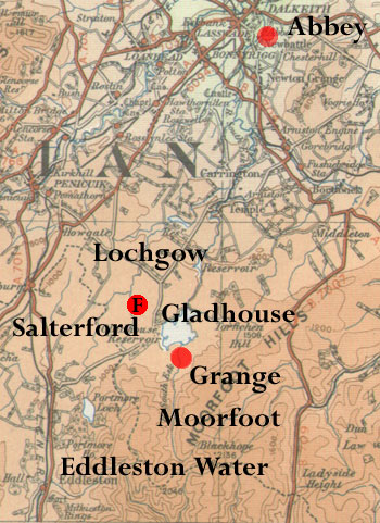 Several
charters (25 - 32) deal with grants of land in Lochgow,
an area which was a few miles south-east of Penicuik.
Charters 28 and 29 mention a ford on the Perdomainesburne
(identified as the Tweeddale Burn) somewhere north of
Toxside. It is possible however that with the Loch Burn
running into the Tweeddale Burn, the ford was one shown
on the 6" map as Salterford and close to another
ford. Both fords are on the Loch Burn. Assuming the
Salterford was on one of the Salter's roads it would
have been of some importance. Several
charters (25 - 32) deal with grants of land in Lochgow,
an area which was a few miles south-east of Penicuik.
Charters 28 and 29 mention a ford on the Perdomainesburne
(identified as the Tweeddale Burn) somewhere north of
Toxside. It is possible however that with the Loch Burn
running into the Tweeddale Burn, the ford was one shown
on the 6" map as Salterford and close to another
ford. Both fords are on the Loch Burn. Assuming the
Salterford was on one of the Salter's roads it would
have been of some importance.
Also mentioned is Hathyrbrig in charters 31 and 32,
possibly bundles of heather placed across boggy ground
(cf. DSL Hather). Although some of the placenames like
Kingside and Mount Lothian can be recognised they are
not enough to identify the location of this "heather
bridge" - though it may not be of much importance.
There were also grants of Moorfoot and Gladhouse in
free forest, with a grange at Moorfoot, just south of
Gladhouse reservoir. Pasture on the west side of Eddleston
Water was granted in charter 31.
Although roads/tracks are not mentioned we can assume
considerable movement in the area. The Lochgow area
would have been near a route to Peebles passing through
Howgate and Leadburn, then down the Eddleston Water.
While Newbattle could be easily reached from Howgate,
it is not clear what route could have been taken. The
grange at Moorfoot presumably had a link to the abbey,
which may have taken a general northward direction through
Temple and Carrington.
EDINBURGH
Charter 299, Page 266
This refers to what was probably the High Street in
Edinburgh (vici regii).
Carta Henrici tendeman •
Charter 48, Page 38
This charter by Henry Tendeman, a merchant of Leith,
and his wife gave Newbattle some land in Edinburgh "next
to the road which goes to Leith" (proxiam vie per
quam itur versus leeth).
Charter 281, Page 238
This charter of the early 1400's mentions a road going
between Edinburgh and Leith.
....in Edinburgh next to the road which goes to Leith
.... in villa de Edynburgh iuxta via
qua itur versus Leth
Interpretation
As noted here,
this road or roads would not have been Leith Walk which
dates from the 17th century but one of the other available
routes. The Nor' Loch would have forced those coming
from the High Street area to skirt it either on the
east or west sides.
KRESSEWELLE
Carta Hugonis Gyftard •
Charter 81, Page 63
This was a charter of Hugh Gifford donating the
lands of Cresswell to Newbattle Abbey. it was just to
the south-east of Haddington and is now known as Monkriggs.
A road is mentioned. It is dealt with under East Lothian
here.
BEREFORD (See above map)
Charters 87 & 88, Page 66
These charters of of John and Thomas of Morham refer
to a mill pond at Bereford and to the firm land of Morham
and the ford of Bereford. This ford is probably over
the Bearford Burn and on the road called the Stabstone
Loan which led to Garvald, and which in part may have
been the Monkesgate leading from this locality to a
petary in Crumbrestrother. They are dealt with under
East Lothian here.
CRUMBRESTROTHER
Carta Alexander de Sancto Martin
Charter 102, Page 76 and others
Several charters refer to a petary in Crumbestrother,
along with roads and paths. The charters however are very
difficult to interpret although one of the roads may be
the Monkesgate leading from the granges near Haddington
to the petary. They are dealt with under East Lothian
here.
WESTFORTON & DREM
Carta Nesi • filii Johannis de lundres •
Charter 107, Page 80 and charter 114
These two charters for a locality just north of Haddington
mention a road (probably the same road) in the vicinity
of Westforton and Drem. They are dealt with under East
Lothian here.
EDINGTON
Carta Johannis de Edynton
Charter 205 Page 164
This gave Newbattle the right to travel through Edington
on their way to and from Berwick, 12 miles away. The
route followed is not certain but could well have been
through Ellem and Cranshaws towards the granges at Haddington.
They are dealt with under East Lothian here.
WEST BINNING
Newbattle Register, Charter 308, Page 281. Date 1500
This charter, dating from 1500 refers to the common
highway between Linlithgow and West Binning near Uphall.
It is dealt with under West Lothian - see here.
KINPONT, NEAR UPHALL
Books of Assumption of Thirds of Benefices (Newbattle
Register, Page 329)
Kynpont is listed as a property of Newbattle at the time
of the Reformation. The name means head of the bridge
indicating that there had been a bridge here at one time.
Kinpont is located one mile east of Broxburn. The charter
is dealt with under West Lothian - see here.
Top
|